Main Body
Chapter 11
Topic 11 – The New Global Tectonics
“The plates in dynamic mosaic through history both fresh and archaic like bold engineers for some two billion years have kept Earth from becoming prosaic.” – Jack Oliver
Before the 1960s, theories on how mountains ranges like Asia’s Himalayas and North America’s Rocky Mountains had been built to such staggering heights were largely based on ideas about how the Earth’s crust must have folded and contorted during contraction as it cooled after its original formation. In the early 1960s evidence for movement at a continental scale in Earth’s outermost crust began to fall into place. Now measurements by high precision laser and global positioning systems (GPS) confirm that the lithospheric crust of the Earth is comprised of a series of interlocking plates that move, deform and dynamically interact through the process of tectonics.
Earlier in these readings we defined the solid Earth as being composed of distinct layers, the outermost layer a relatively thin, brittle material representing the lithospheric crust. Immediately below this layer heat and pressure support a more plastic, deformable layer of rock, near its melting point called the Asthenosphere. Recall that there are two general types of tectonic plates (based on mineral composition) that make up the upper surface of the lithospheric crust:
• oceanic crust (Density ~3.0 g/cm3)
• continental crust (Density ~2.7g/cm3)
See the overview of plate tectonics here:
https://www.youtube.com/watch?v=zbtAXW-2nz0
https://www.youtube.com/watch?v=kwfNGatxUJI&
In the early 1900s some scientists hypothesized that the continents had moved significantly in the geologic past. This was based on a few lines of evidence:
• Similarity in geology and apparent age of mountain ranges now on separate continents
• Apparent fit of continental margins like a jigsaw puzzle
• Similar fossil remains found on now widely separated continental locations
• Record of significantly different climate in the geologic past for some continental locations, indicating they had moved from different latitudes
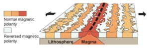
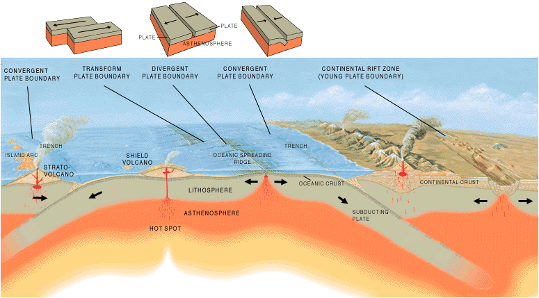
Although this evidence demanded some consideration at the time, it was not conclusive on its own. One of the defining moments in driving plate tectonics forward as a viable theory was the systematic mapping of major ocean-floor ridges (for example, the mid-Atlantic ocean ridge). These ocean ridges represented locations where the oceanic crust was separating and diverging in opposite directions as the underlying tectonic plate was exposed to extensional stress, allowing magma (liquid rock) to come to the surface and form new crust. Magnetic surveys and age dating of the rocks around spreading ocean ridges confirmed that the rocks on either side of the ridges had matching magnetic fields and were similar age and therefore had likely formed in the same location, later drifting apart. It was also found that the accumulation of ocean-floor sediment increased with increased distance from ocean ridges, indicating the further away from the ridge you travelled, the older the crust became.
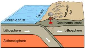
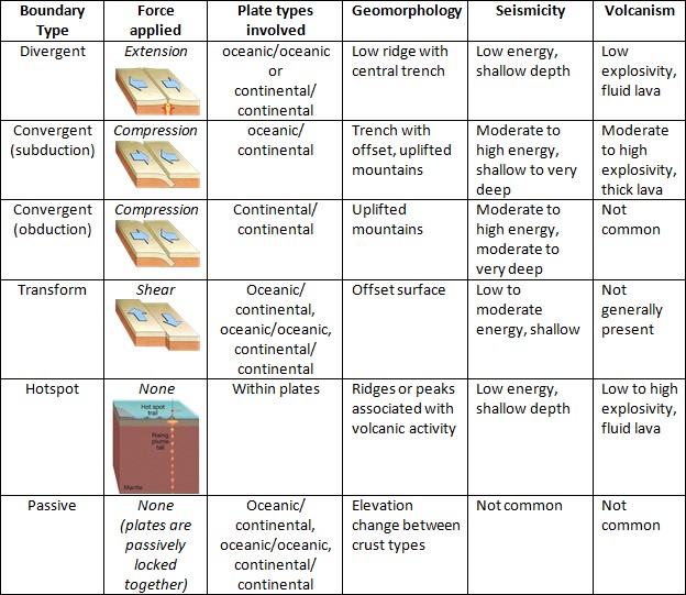
If new crust is being created in one location, it indicates that it must be recycled at another. Where two tectonic plates actively meet (converge), the higher density crust sinks (subducts) beneath the less-dense crust, eventually sinking into the mantle where it can be recycled as new rock. As the crust sinks into the mantle it acts to heat and melt the continental crust above, generating surface volcanic activity. Where tectonic plates of similar density converge, they compress and deform, thrusting the crust vertically into mountain ranges (obduction), where the material is exposed to extreme weather conditions and rapidly weathered into sediment.
While we understand the relationship between tectonic plates somewhat well, the driving mechanism for plate movement is less well understood. For a long time scientists have hypothesized that large-scale convection currents move heat from Earth’s core, through the mantle towards the lithospheric crust. Upon encountering the crust, it is likely that these currents have the ability to invoke some drag on the underside of the crust; however, it appears this is not enough force to generate the apparent movement of the plates. Instead a second mechanism called ‘slab pull’ linked with the movement of the plates themselves may be more significant. As new material is erupted at a divergent boundary, it cools and becomes more dense, sinking into the mantle. This sinking acts to exert a small pull on the divergent boundary. Furthermore, as a tectonic plate subducts into the mantle, the sinking of this plate likely exerts a large pulling force on the rest of the still buoyant plate, dragging it towards the subduction zone.
When two neighbouring plates move at different rates of speed, a shear zone forms between them to accommodate the different lateral movement. This is called a transform boundary and may generate moderately large earthquakes, such as those along the San Andreas fault system in California.
Where volcanic activity occurs far from any apparent plate boundaries, it appears that an upwelling of material in the mantle at that point location may be responsible. These ‘hotspot’ locations in the mantle are responsible for volcanic activity in relatively remote locations, like the Hawaiian Islands.
fold is used in geology when one or a stack of originally flat, level surfaces, such as sedimentary strata, are bent or curved as a result of pressure and high temperature (Wiki)
A wave-like geologic structure that forms when rocks deform by bending instead of breaking under compressional stress. (Geologypage)
molten rock below the surface, either held within the crust or in the mantle. (itsEducation)
Molten rock originating from the Earth's interior (PhysGeo.net)
one of the tools used by exploration geophysicists in their search for mineral-bearing ore bodies or even oil-bearing sedimentary structures and by archaeologists to locate and map the remains of buried structures (Britannica)
are a geophysical method to image anomalies in the earth’s magnetic field caused by source bodies within the sub-surface (SEGwiki)
All absolute isotopic ages are based on radioactive decay, a process whereby a specific atom or isotope is converted into another specific atom or isotope at a constant and known rate. (Britannica)
Radiometric dating calculates an age in years for geologic materials by measuring the presence of a short-life radioactive element, e.g., carbon-14, or a long-life radioactive element plus its decay product, e.g., potassium-14/argon-40. The term applies to all methods of age determination based on nuclear decay of naturally occurring radioactive isotopes (nps.gov)
Subduction occurs when an oceanic plate runs into a continental plate and slides beneath it. (usgs.gov)
the sideways and downward movement of the edge of a plate of the earth's crust into the mantle beneath another plate. (google)
the sideways and upwards movement of the edge of a crustal plate over the margin of an adjacent plate. (google)
The process whereby ocean crust (and even upper mantle) are scraped off the descending ocean plate at a convergent plate boundary and thrust onto the adjoining plate. Often associated with an accretionary wedge (prism). (Geological Society)
Heat generated by the breakdown of radioactive minerals in the mantle is redistributed by currents that rise at the mid ocean ridges and descend at the ocean trenches. Convection currents were long thought to be responsible for driving plate motion but this is still the subject of intense debate. (Geo Society)
occur within the molten rock in the mantle, act like a conveyor belt for the plates. Tectonic plates move in different directions. The direction of movement and type of plate margin is determined by which way the convection currents are flowing. (ALevelGeo)
As oceanic lithosphere cools, it becomes denser and thicker. At a convergent plate boundary the oceanic lithosphere sinks beneath the adjacent plate forming an ocean trench and subduction zone. As a result of its own weight, the descending plate is pulled by gravity through the mantle asthenosphere, which is hotter and less rigid. This force is known as slab pull. It is believed to be the major force driving plate motions. (Geo Society)
older, colder plates sink at subduction zones, because as they cool, they become more dense than the underlying mantle. The cooler sinking plate pulls the rest of the warmer plate along behind it. (bgs.uk)
may be more precisely defined as approximately tabular regions of concentrated deformation and flow across which adjacent relatively undeformed rock units are offset (Shear zones — an introduction and overview)
also sometimes called ductile faults, are intensely strained zones that separate less severely deformed units (UA Online course lecture)
one in which two plates slide past one another and crust is neither created nor destroyed, but is conserved (Geo Society)
are places where plates slide sideways past each other. At transform boundaries lithosphere is neither created nor destroyed (Cornell Online)
are places within the mantle where rocks melt to generate magma (oregonstate online)
A hot spot is an area on Earth that exists over a mantle plume. A mantle plume is an area under the rocky outer layer of Earth, called the crust, where magma is hotter than surrounding magma (NatGeo)