Main Body
Chapter 17
Topic 17 – Drainage Basin Hydrology
Hydrology is the science of water. Water moves through Earth systems by following stages in the hydrologic cycle. Most of the water (~96%) in the hydrologic cycle is stored in the Earth’s oceans. About 86% of global evaporation occurs over the oceans, but because of global winds and precipitation mechanisms (like orographic rainfall), only about 77% of precipitation occurs over the oceans, the rest falls on land. Precipitation falling over the land surface is received in a ‘drainage basin’ a unit of land defined by topography and the collection of water as it flows downslope. A drainage basin (also known as a ‘watershed’) is defined by drainage divides, topographically high points of land that divide water flow from one location to another. The water in a drainage basin all drains into a common outlet, like a river, lake, or ocean. 
You can virtually interact with the world’s drainage basins here to get a sense of their geography: http://riverbasins.wateractionhub.org/
The systems approach of understanding the Earth often looks at environments from the perspective of the drainage basin. Drainage basins are effective units of ecological management because the availability of water is a significant limiting factor for many other parts of the critical zone including soil and vegetation. Hydrologists focus their work on understanding the quality, quantity, and patterns of movement for water through a landscape.
As water falls as precipitation on a landscape, it has multiple pathways it can take. If it falls as snow it may be stored in place for a time, or freeze into glacial ice over longer time periods. If it falls as rain, it may flow over the surface, collect in rivers or lakes, or infiltrate into the surface where it can enter the groundwater system. Each part of this system has differences in residence time (how long the water stays in that part of the system).
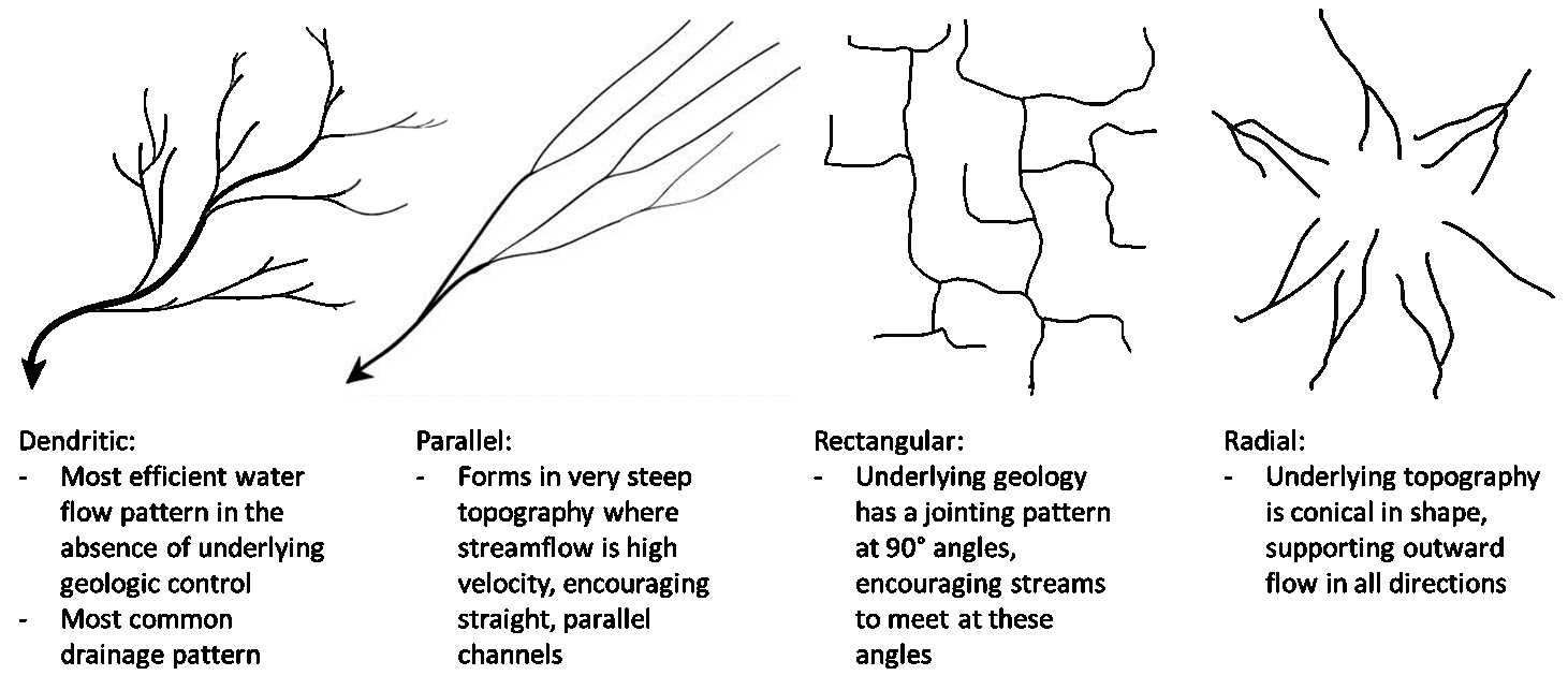
As water initially flows over the land surface unconstrained by a channel, it is referred to as overland flow. Eventually, increased depth of water flow makes this type of movement unstable and the water separates into channels, referred to as streamflow. The organization of different drainage patterns on the landscape is related to underlying geology and the efficiency of water flow. A few of the more common drainage patterns and their controlling factors are listed below:
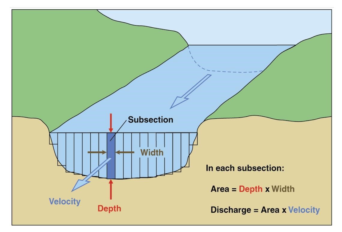
Streamflow is quantified by ‘discharge’ which measures the volume of water passing a point in the stream over a period of time, usually cubic metres/second. Discharge is measured by multiplying the area of the stream by the velocity of the water passing through that area.
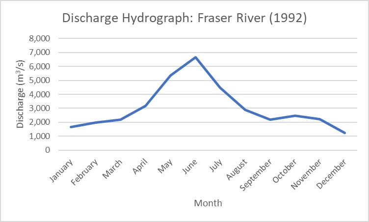
Discharge in an individual stream can be highly variable over different timescales, from year to year, season to season, and day to night. Changes in discharge may be related to different parts of the hydrologic cycle, such as storm events within the drainage basin, snow or glacier melt, inflow from groundwater, or other factors. Often discharge is represented using a discharge hydrograph that shows discharge on the y-axis of a graph, with time on the x-axis:
Understanding discharge is significant because:
- Changes in discharge lead to significant changes in erosion and deposition patterns in the hydrologic system.
- Higher discharge allows a stream to transport a larger load of sediment.
- Discharge patterns can be used to monitor for potential flooding and periods of low water availability.
- Monitoring long term discharge allows better management of stream resources when humans remove water from a system for irrigation or other purposes.
- Understanding the range of potential discharge in a stream is important when engineering critical structures like bridges.
Changing climate has the potential to disrupt current patterns of hydrology around the globe. Environmental research has demonstrated that climate has a significant impact on things as simple as the angle at which tributaries flow into a river (e.g., drainage pattern)
See this article for more info: https://eos.org/research-spotlights/stream-network-geometry-correlates-with-climate
More complex relationships occur where hydrologic resources are shared across political borders in areas where water resources may be scarce. Future changes in climate and hydrologic discharge could increase stress on available water resources.