Main Body
Chapter 18
Topic 18 – Fluvial Geomorphology
Rivers are a critical part of the water cycle, and one of the most visible components of the hydrosphere. They support diverse ecological habitats. The shape and patterns present in a river system 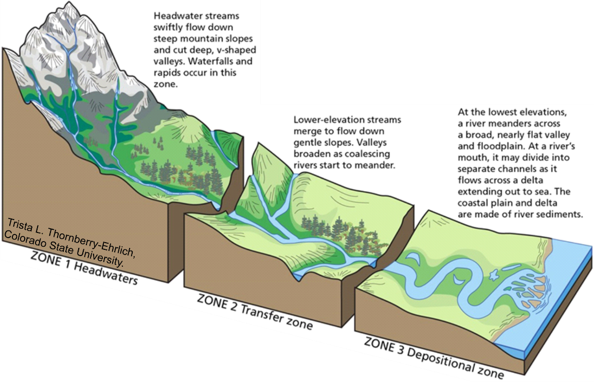 are based on the dynamics of water flow through the system (for example: discharge) and the environment the water is flowing through (river bed material, topographic slope of the river bed). These factors combine to produce the geomorphology of the river system (fluvial geomorphology). Generally the fluvial system can be split into three separate zones, based on topographic differences:
- Headwaters
- Transfer zone
- Depositional zone
These zones are related to conditions external to the fluvial system itself, specifically topographic slope.
There are three critical components to the fluvial geomorphology system:
- Erosion (most active in the headwater zone)
- Transportation (dominant in the transfer zone)
- Deposition (most active in the depositional zone)
The idea of erosion in the fluvial system is based on removing material from the surrounding environment and making it a part of the stream load (what the stream is carrying). Once material is removed and caught up in the stream load, it is being transported. At some point downflow, the fluvial system stops transporting the material, and deposits it at the stream bed. It stays in this position until the erosion process begins again. Material eroded, transported, and deposited in the fluvial system is referred to as alluvium.
There are several styles of erosion that commonly occur in the fluvial system:
| Environment | Erosion Type | Erosive Power | Process |
| Overland flow | Splash erosion | Low | Individual raindrops impact the surface, dislodging particles at the surface. |
| Overland flow | Sheet erosion | Low | Shallow sheets of water running over the surface abrade the surface material. |
| Stream flow | Hydraulic action | Moderate to high | The motion of water directly over the stream bed rubs material away directly from the stream bed. |
| Stream flow | Bank undercutting | Moderate to high | Water flowing at the base of river banks removes materials, destabilizing the above slopes, leading to collapse. |
| Stream flow | Abrasion | Moderate to high | Stream load (like sand and silt particles carried by the stream itself) rub against the stream bed, scraping the material away. |
| Stream flow | Corrosion | Moderate to high | Material in the stream bed that is soluble (can be dissolved) in water is dissolved into the water itself and carried away. |
Once eroded, material becomes part of the stream load, and is transported. Transport can happen in several modes, dependent on the size of the sediment and the velocity of the stream (a higher velocity stream can transport larger sediment). The two principles governing these limits on transport are referred to as competence and capacity.
Competence: the largest material size a stream can transport in a given stream segment. This value is largely based on velocity of the stream.
Capacity: the overall volume of material a stream can transport in a given stream segment. This value is based on both the velocity and volume of water in the stream.
Three types of stream transport:
- Dissolved load: Materials that are soluble in water and have been dissolved into the stream water itself. Usually this material is not deposited until the water in which it dissolves is evaporated.
- Suspended load: Materials light enough to be carried high in the water column itself. Usually this is limited to the lightest clay and silt-sized particles. This material is deposited when water velocity slows to the point where competence is no longer sufficient to carry the load.
- Bed load: Materials to heavy to be carried high in the water column, but that have been dislodged at the stream bed. These are bounced, dragged and rolled at the stream bed by traction from the overlying stream flow.
Differences in stream velocity lead to deposition of stream load at various points in the fluvial system. This is based on where the thalweg, or zone of fastest flow, is in the stream. In a perfectly 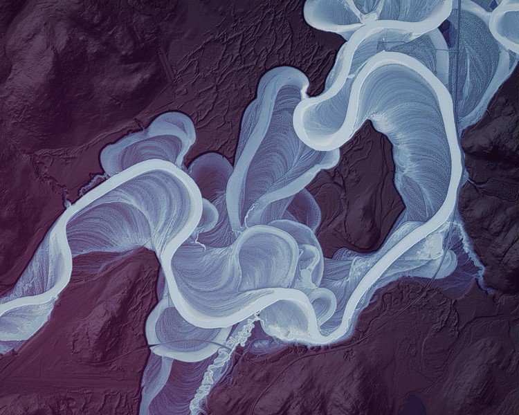 straight stream channel, the thalweg would be at the centre of flow. In a sinuous or curved channel, the thalweg bounces back and forth across the channel, leaving zones of lower velocity on alternating sides of the channel. This alternating pattern creates a situation where bends in the river alternately promote the aggradation (accumulation) of sediment, and degradation (erosion) of sediment. The result is an alternating pattern of point bars, the result of sediment aggradation, on the inside bend, where stream velocity is lowest, and cut banks, the result of degradation, on the outside bend where stream velocity is highest. Over time, these complementary patterns shift the entire course of the stream from one location to another.
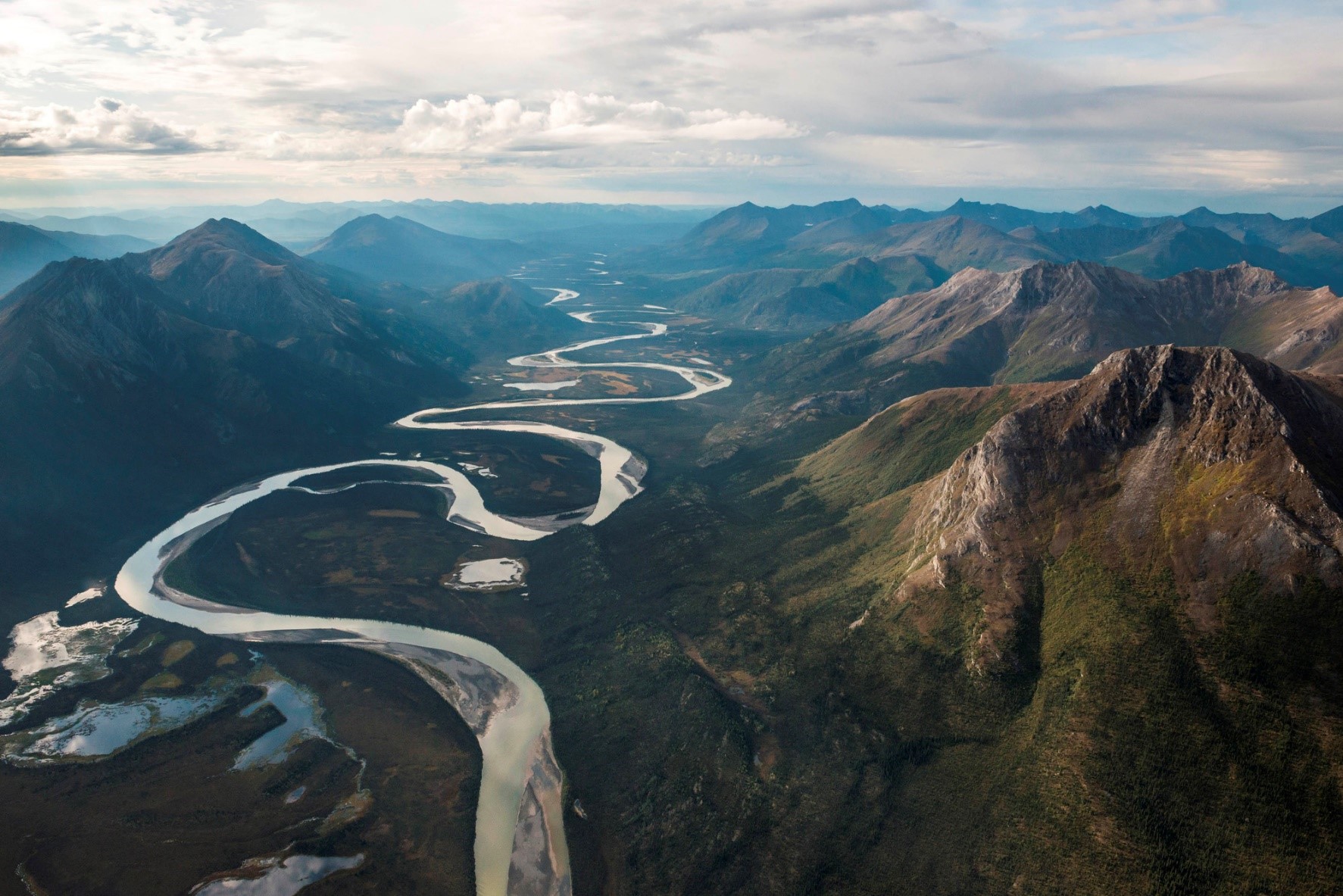
This leads to streams with different planforms (what a stream looks like from above). As shown on the figure at the beginning of this chapter, in the steep, upper reaches of a stream, more energy is devoted to downcutting, creating deeply incised valleys, and relatively straight channels. In the lower reaches of the stream, lower gradient results in more energy applied to eroding the edges of the stream, resulting in a more meandering, broader channel.
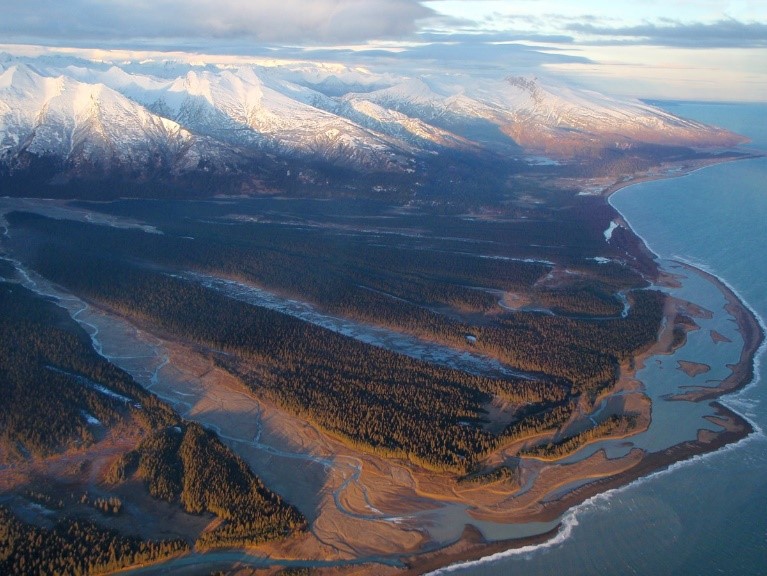
Ultimately some stream load makes it all the way to base level, the lowest elevation of the river flow. Here it is deposited in a fan or delta, that builds outwards.
Figure: Delta forming at the outlet of the Red River as it reaches Cook Inlet in Alaska (NPS: Public Domain)
In this way a stream can lengthen itself, by building its fan or delta outwards at the terminus. It can also stretch itself backwards through erosion at its headwaters where water initially transitions from overland flow to channelized flow.
Rivers represent some of the most dynamic drivers of landscape change around the world. They have the ability to do significant geomorphic work and transform landscapes over very long to very short periods of time.