Main Body
Chapter 2
Topic 2 – Location, Location, Location
As a subject, Geography is sometimes briefly explained as: what is where, and why. The where is an important component of this question and geographers have several key ways to communicate location in 3-dimensional space. This is an introduction to location and how we represent location on maps.

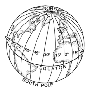
Location is generally communicated using ‘coordinate systems’. These systems allow us to measure the relative location of anything in reference to an agreed datum (or point of origin). Globally, the most commonly used coordinate system is the ‘geographic coordinate’ system based on latitude and longitude lines that encircle the globe. These intersecting grid lines at the surface of the Earth are measured from a specific point of origin. The equator is one such line, and represents the zero point for lines of Latitude. Circling the globe, it is defined by the edge of a plane that bisects the Earth, perpendicular to its axis of rotation. All other lines of latitude run east/west, parallel to the equator, increasing in value north or south, towards the poles. Lines of Longitude (meridians) encircle the globe from north to south, increasing from zero at the Prime Meridian. Therefore the datum, or origin, for geographic coordinates are the Equator (0° latitude), and the Prime Meridian (0° longitude). Note: because all lines of longitude are perpendicular to the equator, they converge on the spherical surface of the Earth at the exact point where the axis of rotation intersects the Earth’s surface, creating the north and south geographic poles. There is a unique value for latitude north or south of the equator and longitude east or west of the Prime Meridian for each location on Earth.
Geographic coordinates are particularly useful at the global scale because they successfully deal with the Earth as an approximate sphere and not as a flat surface. Latitude, for example, is defined as the angle given by a line drawn from the Equator to the centre of the Earth and back to the Earth’s surface for your location. So these coordinates are really angle measurements, and their unit of measurement is degrees. While they do well to measure location on a spherical surface, degrees are not that intuitive for making other geospatial measurements, such as distance. As a result, other coordinate systems have been suggested.
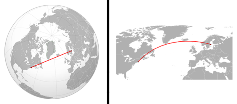
What happens when you flatten a spherical globe onto a flat map?
In order to flatten out the Earth, a number of distortions are necessary. Flat paper maps at the global scale have significant distortion, either in shape, distance, angle or direction. The process of moving from a spherical globe to a flat paper map is called map projection. There are a multitude of ways to project a spherical globe onto a flat surface, and the choice of projection is largely based on the needs of the mapmaker, and what type of distortion they are trying to minimize.
For maps of the entire world, the spherical shape of the Earth is significant, however when a map is focused on just a small part of the world, the curved surface is less apparent. The area of the Earth represented on a given map surface is referred to as map scale. Simply defined, map scale = distance on the map/ distance on the Earth. World maps are generally low in detail, as they have to cover a large area and are referred to as small-scale maps. As the mapmaker focuses on smaller areas, more detail can be added, increasing the scale at which individual features are represented, we call local maps that represent the Earths surface in high detail large-scale maps.
When dealing with large-scale local maps, distortion from Earth’s curvature is minimized and so we can apply other coordinate systems, such as those based on cartesian grid coordinates with an x and y value, applied on a flat (non-spherical) surface. The most common grid system applied to local maps is the Universal Tranverse Mercator (UTM) system. This system measures in metres from a specific origin (datum) point. For an in-depth explanation of the UTM system see here : Note: keep in mind that because the lines on a grid coordinate map do not converge at the top of the map (like on a sphere), Grid North (the top of the map) is different than geographic north. Furthermore, the magnetic north pole is not perfectly aligned with either of these north’s. Therefore on any given map there may be up to three different definitions of north you should be aware of.
A geographic coordinate system is a three-dimensional reference system that locates points on the Earth's surface. The unit of measure is usually decimal degrees. A point has two coordinate values: latitude and longitude. Latitude and longitude measure angles.
The angular distance, usually measured in degrees north or south of the equator. Lines of latitude are also referred to as parallels. (ESRI)
Geographic coordinate that specifies the north–south position of a point on the Earth's surface. Latitude is an angle (defined below) which ranges from 0° at the Equator to 90° (North or South) at the poles. (Wiki)
is the distance on the earth’s surface, east or west of a defined meridian, usually the meridian of Greenwich, England (0° Longitude), expressed in angular measurements from 180° West (or -180°) to 180° East. (Caliper)
The angular distance, usually expressed in degrees, minutes, and seconds, of the location of a point on the earth's surface east or west of an arbitrarily defined meridian (usually the Greenwich prime meridian). All lines of longitude are great circles that intersect the equator and pass through the North and South Poles. (ESRI)
Small scale maps show a larger geographic area with few details on them. The RF scale of a small scale map would have a much larger number to the right of the colon such as 1 : 1,000,000. Small scale maps are used to show the extent of an entire country, region, or continent. (GISLounge)
Large scale maps show a smaller amount of area with a greater amount of detail. The geographic extent shown on a large scale map is small. A large scaled map expressed as a representative scale would have a smaller number to the right of the ratio. For example, a large scale map could have a RF scale of 1 : 1,000. Large scale maps are typically used to show neighborhoods, a localize area, small towns, etc. (GISLounge)