Main Body
Chapter 3
Topic 3 – Our Private Universe
Averaged across the Earth, throughout the 24 hour day, the Sun delivers 340 watts/m2 of radiation to the top of Earth’s atmosphere. This constant supply of ready energy powers the critical zone of our planet in significant ways, including driving global circulation patterns in our atmosphere and oceans and providing the basis for photosynthesis and the production of biomass.
With respect to energy, the Earth is an open system. We receive energy from the Sun and we re-emit energy back to space. Energy contributed to the system by heat from the Earth’s core represents a fairly small portion of this exchange, about 0.03%.
There are three basic controls on the delivery of this energy to the surface of the Earth:
- The spherical surface of the Earth results in different surface area exposed to the same incoming radiation.
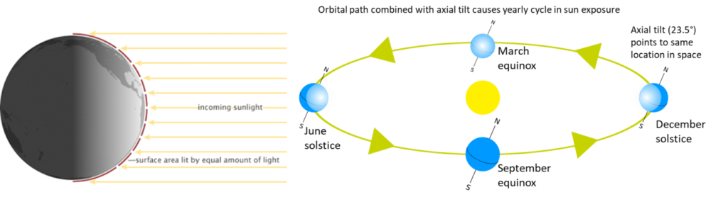
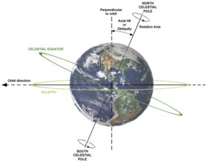
- The axial tilt of the Earth results in the same parts of the Earth alternatively pointing towards or away from the Sun during different parts of Earth’s orbit around the Sun, and changes in the length of day throughout the year.
- The rotation of the Earth on its axis results in daily changes in incoming solar radiation for a single location on the Earth’s surface.
To look at how the orbital patterns and tilt change the Sun exposure for several locations on the Earth’s surface throughout the year, check out the simulation here: https://sepuplhs.org/middle/iaes/students/simulations/sepup_seasons5.html
The angle at which the Sun’s radiation encounters the top of the atmosphere and the Earth’s surface is known as the angle of incidence and is significant for two reasons:
- A steeper angle of incidence focuses solar radiation over a smaller surface area
- A steeper angle of incidence reduces the amount of atmosphere through which the radiation has to travel before encountering the Earth’s surfaceFor every latitude, the angle of incidence changes throughout the year with the seasons.
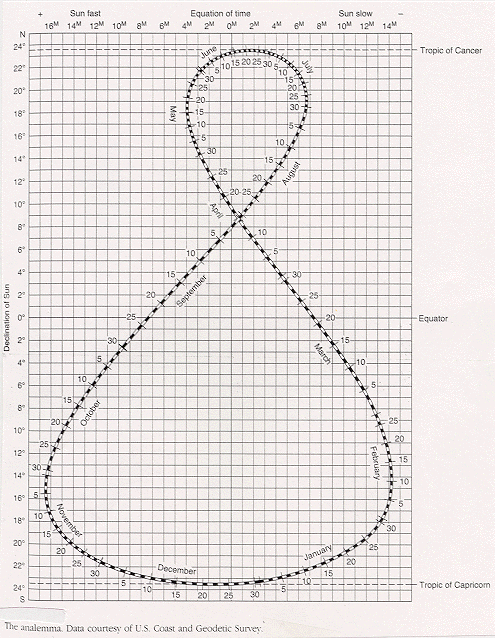
For any given day of the year, the latitude of the subsolar point is the latitude where the Sun is directly overhead (angle of incidence = 90°). At the equator at midday (noon), the Sun is directly overhead (angle of incidence of 90°) twice a year, during the equinoxes. On the June solstice, the Sun is directly overhead at the Tropic of Cancer (latitude 23.5° N). On the December solstice, the Sun is directly overhead the Tropic of Capricorn (latitude 23.5° S). On these days, at any other location on the Earth’s surface, the angle of incidence will be <90°. You can calculate the local angle of the noon Sun (ANS), for any latitude on the Earth’s surface on any day of the year using the Analemma and the following equation:
ANS=90°-(Latitude ±Latitude of the Subsolar Point)
- ANS is the angle of incidence of the noon sun (expressed in degrees)
- Latitude refers to the location on the Earth for which you want to know the ANS
- Latitude of the subsolar point (LSP) read from the Analemma. We are interested in the total difference in latitude between our location and the LSP (± depends on its position with respect to the equator)
The energy system is not just about delivery, its also about how that energy interacts with the Earth once it gets here. This is governed by physical processes like reflectance, transmission, and absorption within the atmosphere and at the Earth’s surface. Reflectance off of any surface is determine by its albedo, the proportion of radiation absorbed vs. reflected (0 = perfect absorption, 1 = perfect reflectance). A higher albedo surface will reflect more incoming sunlight. Snow, for example has a very high albedo (~0.9), whereas water is moderately reflective (~0.6) and a coniferous forest canopy has low reflectivity (~0.14). The distribution of these surfaces is a feedback on temperature distribution around the globe. For example, high albedo of snow and ice surfaces keeps an already cold Antarctic region, even colder because of high levels of surface reflectance. As Earth receives solar energy, that energy is redistributed around the globe through atmospheric and oceanic circulation. Specifically warm air and water from the Tropics are cycled towards the polar regions where they contribute to warmer temperatures. As these currents cool they cycle back to the Tropics where they are again warmed. Heat is transferred from these ocean currents to the atmosphere and back again, creating opportunities for significant global circulation of energy.
the angle at which the Sun's rays strike the Earth's surface (PhysGeography.net)
In reference to solar energy systems: the angle a ray of sun makes with a line perpendicular to a surface (OpenEI)
At any moment there is one spot on the Earth where the sun is directly overhead. This spot, called the subsolar point, moves around the Earth in one solar day, 24 hours, thus the subsolar point moves 15 degrees of longitude for each hour of the day. Where this subsolar point is located defines our seasons. (NY University online)
is a measure of how much light that hits a surface is reflected without being absorbed (NC Climate Office)