Main Body
Chapter 6
Topic 6 – Global Circulation
“When we try to pick out anything by itself, we find it hitched to everything else in the Universe.” – John Muir
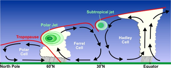
Recall from earlier class discussions that the Earth is heavily dependent on the Sun’s energy. This is not just for providing humans with the energy needs we have come to be dependent on, or even just for plant productivity and photosynthesis, but it extends all the way to driving the weather patterns we experience on a daily basis. In the atmosphere, low pressure air masses are defined by rising air, warmed by the Sun’s energy, and high pressure air masses are defined by descending air. This air moves vertically and horizontally following the pressure gradient (flowing from high to low pressure areas). The Hadley Cell is one example of this movement, but there are others including the Polar Cell which exists over the north and south polar regions, circulating mild air from the midlatitudes towards the extreme environments at the poles. These convection cells work to circulate air from the equator where it is warmed most efficiently, towards the coldest parts of the globe, resulting in a planet with less extreme temperature patterns. See how the Coriolis Effect works here: https://www.youtube.com/watch?v=PDEcAxfSYaI&
But the path of air towards the poles is not as straightforward as it might seem. The pressure gradient is the primary driving force for air circulation, but there is a secondary force, the Coriolis effect, that acts on air circulation at the global scale. The Coriolis effect impacts any fluid that travels over a rotating body. With respect to Earth, this includes atmospheric gases and liquid surface water that exist atop the rotating Earth. The Earth’s rotation appears to deflect the movement of fluids as they travel. In the northern hemisphere, fluids appear to deflect to the right from their place of origin, and in the southern hemisphere they appear to deflect to the left. This means that an air mass traveling north from the equator will not travel in a straight line towards the north pole, but instead will appear to deflect to the right, relative to the Earth’s surface.
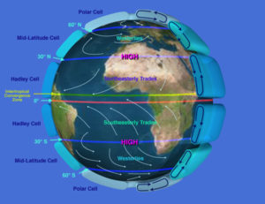
If we apply this new force to the horizontal components of the Hadley Cell model of circulation, we find that as air rises above the equator and flows to the north (in the northern hemisphere) it is deflected to the right (or from west to east). When it descends over midlatitudes and some of it flows south back towards the equator, it is again deflected to the right (this time from east to west). This generates a series of airflow patterns that are nearly as constant as the Hadley Cell itself over the tropical regions of the Earth . In the tropics, air flowing from east to west at the surface is referred to as the Trade Winds, and these are ‘easterly’ winds (flowing from the east). Aloft, high up in the atmosphere, air flowing from west to east is known as the anti-Trade Winds, and these are ‘westerly’ winds (flowing from the west).
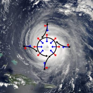
Through satellite imagery, we’re now used to seeing images of massive storms like hurricanes that travel across our planet. Storms are carried through the atmosphere by winds like the Trade Winds. But you may have also noticed that these storms rotate around a central point. This rotation is produced by the compound effect of the Pressure Gradient force and the Coriolis force. If you visualize a low pressure centre, air should flow in towards the middle, along the pressure gradient. As that air encounters the Coriolis effect, it curves to the right (in the northern hemisphere). As these two forces balance, the air rotates endlessly around the Low pressure centre in a counter-clockwise direction . This is called cyclonic flow or a Cyclone. For high pressure centres the air flows from the high pressure zone outwards, following the pressure gradient. Again, it curves to the right, rotating this time in a clockwise direction. This is called an anti-cyclone. The winds generated by this endless rotation around the pressure centre are referred to as geostrophic winds. Closer to the Earth’s surface, friction generated as air moves overtop of the Earth’s crust begins to impact air movement. Surface winds are also impacted by surface friction, and are a balance between the frictional force, the pressure gradient force and the Coriolis force. Surface friction acts more to reduce the pressure gradient force than the Coriolis force and therefore winds eventually cycle in towards the centre of a low pressure system or out of a high pressure system.
Solar energy drives rising and sinking air around the globe, which in turn drives high and low pressure systems. As different parts of the globe are exposed to different amounts of sunlight throughout the year, global scale circulation shifts north and south with the seasons. This creates dynamic weather patterns for areas outside of the equatorial zone throughout the year. The latitude of highest temperatures (where sunlight is most direct) for any given time of year is referred to as the Thermal Equator. The thermal equator shifts north and south seasonally roughly in step with the latitude of the subsolar point. This causes the ITCZ to move north and south seasonally, and specific areas of the globe experience seasonally changing weather patterns as a result. For example, the Monsoon climate is driven by this annual north/south shift, as is the shift in Vancouver’s weather from generally stable, clear weather in the summer to alternating stormy/wet and cold/dry patterns in the winter.
A weak meridional circulation in the high-latitude troposphere characterized by ascending motion in the subpolar latitudes (50°–70°), descending motion over the pole, poleward motion aloft, and equatorward motion near the surface (AMS)
Three-dimensional atmospheric circulation cell located at roughly 60 to 90° North and South of the equator (PhysGeo)
Substance that flows and is not solid; smooth and continuous (Merriam)
half a sphere. In geography, the division of the earth either into north and south by the equator, or into east and west by any one line of longitude (ItsEducation)
half a sphere. In geography, the division of the earth either into north and south by the equator, or into east and west by any one line of longitude (ItsEducation)
Latitude of 23.5° North. Northern limit of the Sun's declination
Latitude of 23.5° South. Southern limit of the Sun's declination (PhysGeo.net)
Surface winds that generally dominate air flow in the tropics. These winds blow from about 30° North and South latitude to the equator (PhysGeo.net)
The wind system, occupying most of the Tropics, that blows from the subtropical highs toward the equatorial trough; a major component of the general circulation of the atmosphere (AMS)
the dominant west-to-east motion of the atmosphere, centered over the middle latitudes of both hemispheres (AMS)
Dominant winds of the mid-latitudes. These winds move from the subtropical highs to the subpolar lows from west to east (PhysGeo.net)
Areas of sinking air which result in high pressure (UK Environmental)
a region of high atmospheric pressure relative to the surrounding air (Weatheronline)
An atmospheric pressure system consisting of an area of high pressure and outward circular surface wind flow (PhysGeo.net)
Horizontal wind in the upper atmosphere that moves parallel to isobars (PhysGeo.net)
wind blowing parallel to isobars because of deflection of the pressure-gradient force by the Coriolis Force
Resistance between the contact surfaces of two bodies in motion (Physgeo.net)
Force acting on wind near the Earth's surface due to frictional roughness. Causes the deceleration of wind (PhysGeo.net)
Friction slows the wind down at the surface or in areas with winds of different speeds (wind shear). When the wind is blowing near the surface, the ground creates friction that makes the wind blow slower (NCSU climate)
The line that circumscribes the earth and connects all points of highest mean annual temperature for their longitudes (AMS)
Continuous area on the globe that has the highest surface temperatures because of the presence of the Intertropical Convergence Zone (PhysGeo.net)
Zone of low atmospheric pressure and ascending air located at or near the equator. Rising air currents are due to global wind convergence and convection from thermal heating (PhysGeo.net)
The axis, or a portion thereof, of the broad trade-wind current of the Tropics (AMS)
A name for seasonal winds (AMS)
A regional scale wind system that predictably change direction with the passing of the seasons (PhysGeo.net)
a seasonal prevailing wind (ItsEdu)