Main Body
Chapter 8
Topic 8 — Clouds and Weather Systems
When water in the atmosphere reaches 100% relative humidity, it condenses, forming liquid water or ice. This liquid water reflects and scatters sunlight in many different directions and wavelengths, and when enough water droplets combine, they create the appearance of white clouds. Different types of clouds form from different environmental mechanisms, all of these mechanisms are related to air masses being pushed towards high relative humidity due to temperature changes.
Some cloud-forming processes :
1. Orographic lift: air is pushed up and over topography (a mountain range, for example), and cools as it rises.
2. Convective lift: The Sun heats the Earth’s surface in a specific location, causing the air to warm in that space. The warmer air is less dense, causing it to rise and expand.
3. Frontal lift: Two air masses interact, one is forced to rise above the other because it is warmer and less dense. The boundary where the two air masses meet is called a front.
4. Convergent lift: Rising air in a zone of low pressure creates space below it. Air rushes in to fill this space, converges on other air and has nowhere to go but up.
In all of these cases air is forced to rise. As it does so it cools, increasing the relative humidity, with the potential for cloud formation.
Sometimes the temperature of an air mass might change because it moves over a surface that is a different temperature. For example, when an air mass moves from travelling over relatively warm water, to relatively cool ground, it may cool and condense without rising. Clouds formed next to the ground surface are called Fog.
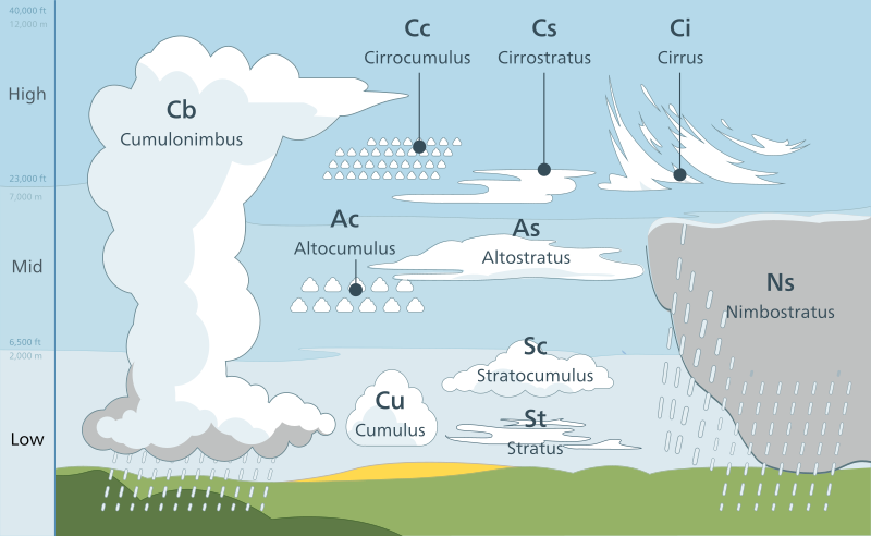
Cloud types are separated based on their appearance, both in shape and height in the atmosphere.
Shape:
• Cirrus = thin/wispy
• Cumulus = heaped/puffy
• Stratus = layered
Height:
• High – Mostly cirrus clouds
• Middle – Alto clouds
• Low – Mostly stratus clouds
The formation of a raindrop begins with a surface on which that droplet can form. Condensation is much easier when there is a surface for water to condense on. In the atmosphere, these surfaces are provided by particulate matter like dust or ash. Microscopic water droplets begin forming on these surfaces called condensation nuclei and grow through collisions with other water droplets. Water droplets or ice crystals in clouds are generally so small and low density that they are less dense than the air below them. This keeps them within the cloud until they form particles large enough to fall. Once a droplet has coalesced into a large enough mass, it becomes more dense than the air below and falls from the cloud.
One of the most important factors in weather forecasting is determining how an air mass will behave when it reaches a geographic location like a city. Some of this is based on what lifting mechanisms might be at work, or the environmental lapse rate at the location of the forecast. But more important than all of this, are the pre-existing conditions of the air mass itself. These conditions are often defined based on where the air mass is travelling from. Air masses that have their source over water (maritime air masses) are generally higher in water content than those travelling over land (continental air masses). Air masses travelling from high latitude areas are generally cooler (polar air masses) than those travelling from equatorial locations (tropical air masses).
As described earlier, when two air masses interact they form a boundary between them based on temperature differences called a front. Two main types of front exist, based on the type of advancing air mass. A cold front exists where cold, dense air is advancing and pushing warmer air out of the way. A warm front exists where cold air has moved out of a region and is replaced by advancing warmer air. Warm air is significantly different density to cold air, and this is reflected in the different shape of these fronts as they move across the landscape. The cloud types produced by rapidly rising air (cumulonimubus in the case of cold fronts) and gradually rising air (stratus in the case of warm fronts) are also different.
In the Pacific Northwest region of North America, during the winter we experience alternating patterns of cold and warm fronts, brought to us by the westerly midlatitude surface winds. The constant change in weather conditions is noticeable as winter storms associated with low pressure systems and warm fronts move through but may be followed by incoming cold fronts and high pressure, stable conditions. These frontal systems are commonly impacted by larger scale weather patterns like El Nina or La Nina, the position of the Jet Stream, and the presence of warm or cold water off the Pacific coast.
the boundary where two air masses meet. (ItsEdu)
the interface or transition zone between two air masses of different density (AMS)
Transition zone between air masses with different weather characteristics (PhysGeo)
Fog exists if the atmospheric visibility near the Earth's surface is reduced to 1 kilometer or less. Fog can be composed of water droplets, ice crystals or smoke particles (PhysGeo)
Water droplets suspended in the atmosphere in the vicinity the earth's surface that affect visibility (AMS)
ground-level condensation caused if the dew point is reached in this part of the atmosphere by advection, evaporation, radiation or at a warm front or over ice (ItsEdu)
Microscopic particle of dust, smoke or salt that allows for condensation of water vapor to water droplets in the atmosphere (PhysGeo)
Hygroscopic aerosol particles that can serve as nuclei of atmospheric cloud droplets, that is, particles on which water condenses (activates) at supersaturations typical of atmospheric cloud formation (AMS)