Main Body
Chapter 12
Topic 12 – Seismicity and Western North America
One does not have to look very far across the varied, rugged terrain of British Columbia to notice that it differs significantly from the rest of Canada. The topographic differences are matched by differences in precipitation, temperature range, hazards, population distribution, economic production, geology, and other parts of the provincial geography. These differences have their roots in BC’s geologic past and how Western North America was formed.
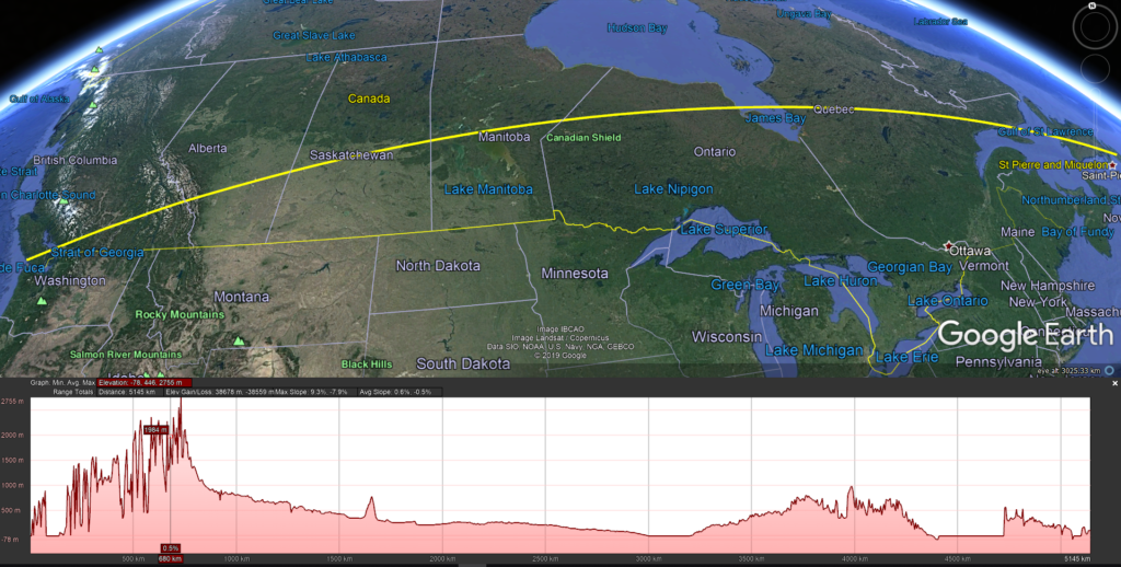
About 290 million years ago according to the Geologic Timescale, the Rocky Mountains did not exist and the west coast of what is now North America was located near the current border of Alberta. The coastline approximated a low angle shoreline, similar to what exists now on the east coast of the United States. Over the next several hundred million years, as the subduction zone off the West Coast of North America operated, new materials in the form of islands were brought the edge of the continent. As the oceanic plate subducted beneath the continental plate, these islands merged with the western edge of North America, compressing it and starting the process of mountain building.
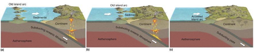
This process of exotic material being brought from far away and slamming into our coastline has been termed ‘terrane accretion’, and it does a good job of explaining two challenging observations of BC’s geology:
1) the significant variation in geology type from west to east across BC (especially when compared with the relatively straightforward geology across the rest of Canada)
2) the north/south orientation of mountain ranges and zones of similar bedrock geology in BC
Additionally, the idea of terrane accretion aligns within the broader model of plate tectonics.
See this image for an example: https://commons.wikimedia.org/wiki/File:AccreWedge.jpg.
There are several pieces of additional evidence that subduction is occurring off the west coast of North America, potentially driving terrane accretion. Global Positioning System measurements confirm that the western parts of the North American continent (e.g., Vancouver Island) are drifting horizontally to the east and also increasing in vertical height, whereas interior locations in the Okanagan Valley are stable in position. This indicates compression of the western edge of the continent.
Other evidence present is in the structural patterns of rocks present across British Columbia. When rocks are compressed they respond by either folding or faulting. Folding occurs under intense heat and pressure when the rock is soft enough to bend. Faulting occurs when the rock is brittle and breaks under the applied compressional stress. The Rocky Mountains display impressive instances of both structural folding and faulting.
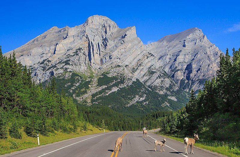
Three types of folds structures may form under compression:
1. Monoclines
2. Synclines
3. Anticlines
See this quick overview of the types of fold structures here: https://www.youtube.com/watch?v=XDIpz9cp4Ko
The folding and faulting process significantly affects topography where these structures connect with the land surface, and so they are an important part of a region’s geography.
Further evidence for active subduction off the coast of western North America is the history of infrequent, large magnitude earthquakes that are the result of slippage along the boundary between the subducting oceanic plate and overriding continental plate. Occurring, on average, every 300-600 years, these earthquakes are recorded in the oral history of indigenous peoples up and down the coastline, and by the record of tsunami events triggered by these earthquakes and observed in Japanese harbours, hours after they travelled across the Pacific Ocean. The last of these events happened in the year 1700, releasing a ~Mw 9 earthquake.
Earthquake energy is released when stress built up in rock mass overcomes the strength of the rock, rupturing it and forming a fault. Energy released from earthquakes travels in seismic waves, in all three dimensions away from the initial rupture zone as ‘body waves’. There are two main types of earthquake waves that travel through the Earth:
– P-Waves – a pushing/pulling motion, travel rapidly through both solids and liquids.
– S-Waves – a shearing motion, travel more slowly and generally only through solids.
Further reading on earthquake generation and their waves here:
http://www.geo.mtu.edu/UPSeis/waves.html; https://www.bgs.ac.uk/discoveringGeology/hazards/earthquakes/seismicWaves.html
Once these waves reach the surface they translate into slow moving ‘surface waves’. There are several types of surface waves, and these are responsible for the majority of the rolling motion felt at the surface during an earthquake.
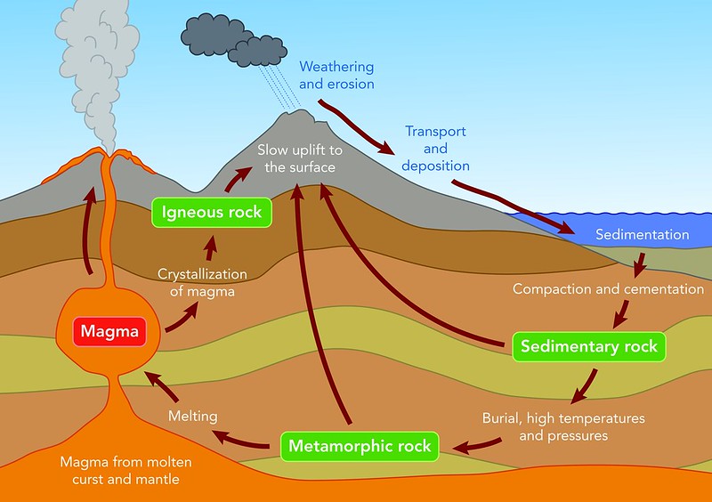
The process of subduction and uplift of land surfaces through folding and faulting play important roles in the rock cycle and the production of topographic variation on the Earth’s surface. The uplift process has lifted former seafloor rocks to the heights of the Rocky Mountains, where some of the richest fossil beds of former sea life have been found. As they are uplifted, these mountains are worn down through exposure to active weather and the rock is slowly broken down into sediment. Sediment is carried back to the topographic lows such as ocean basins, where it can form new sedimentary rock or be carried into the subduction zone and recycled along with the sinking oceanic crust.
a block of crust that has geological features that are distinctive from neighbouring regions, and is assumed to have been moved from elsewhere by tectonic processes (opentext physg)
is technically a tectonostratigraphic terrane, a piece of the earth's crust or lithosphere that has been accreted to the edge of one tectonic plate from another tectonic plate. (commons.wvc.edu)
Accreted terranes are the blocks of continental fragments and oceanic islands that have collided with a continent and are now permanently attached (national park service)
A bend or flexure in a rock unit or series of rock units that has been caused by crustal movements (geology.com)
when one or stacks of originally flat and planar surfaces such as sedimentary
beds become bent or curved as a result of plastic (i.e. permanent) and ductile deformation (files.ethz.ch/structuralgeology)
A fracture in the rock along which movement takes place. A weak area in the Earth's crust where two sides of a fracture or fracture zone move relative to each other. (bgs)
A fracture or fracture zone in rock along which movement has occurred. When movement occurs the vibrations that are produced are known as an earthquake (geology.com)
only one tilted, step-like limb in an otherwise subhorizontal or gently dipping sequence (ethz)
a step-like fold in rock strata consisting of a zone of steeper dip within an otherwise horizontal or gently-dipping sequence (wiki)
a convex-downward fold is a synform. Synclines have younger strata at the core (ethz)
a downward fold where the beds are known not to be overturned (physgeology open text)
A downward fold of sedimentary rock put under pressure by Earth movements (bgs)
A convex-upward fold is an antiform. Anticlines have older strata in the core. (ethz)
an upward fold where the beds are known not to be overturned (opentext physgeo)
Upwardly arched folds of Sedimentary rocks put under pressure by movement in the Earth
A seismic wave that travels through the interior of the earth and is not related to a boundary surface. (bgs)
a seismic wave that travels through rock (e.g., a P-wave or an S-wave (opentext physgeo)
a seismic body wave that is characterized by deformation of the rock in the same direction that the wave is propagating (compressional vibration) (opentext physg)
The first and faster of the body waves which moves by a series of compressions and dilatations, similar to a sound wave. They can travel through both solid and liquid. (bgs)
The fastest set of earthquake vibrations - also known as P-waves. They move through the Earth in compression and expansion motions (much like sound waves move through air). Called primary because they are the first recorded at a seismograph. Primary waves are able to travel through both solids and liquids. (geology.com)
a seismic body wave that is characterized by deformation of the rock transverse to the direction that the wave is propagating (opentext physg)
The second arrival on a seismogram, the S wave, is slower than the P-wave. It is a shear wave and cannot travel through liquids. (bgs)
Seismic waves with motion restricted to near the ground surface (Love and Rayleigh) (bgs)
A type of seismic wave that travels along Earth's surface. These are the waves that cause the most damage during an earthquake. (geology.com)