Strength of Farmland Protection in British Columbia
LEARNING MODULE
Resource
The materials in this module are adapted from the following policy brief:
Connell, David J. (2018). Farmland Protection: Strengthening BC’s Legislation. Prince George, BC: University of Northern British Columbia.
The most common way to evaluate how well agricultural land is being protected is to measure the amount of farmland is converted to other uses, usually to residential, commercial, or industrial uses. Unfortunately, the record across Canada is poor. All urbanised areas have experienced significant losses of its agricultural land base, especially the loss of some of Canada’s best quality farmland.[1]
In British Columbia (BC), the total area of land within the Agricultural Land Reserve (ALR) has remained fairly constant since 1974, with about 4.6 million hectares province-wide (Box 1). However, this overall statistic hides the fact that there have been changes in the types of agricultural land within the ALR. Between 1974 and 2008, the province has lost some of its highest quality agricultural land, mostly to urban development in the Lower Mainland. These losses have been offset by additions of lower capability agricultural land in other parts of the province. Consequently, “the quality of farmland in the ALR has decreased, with 2.8 hectares of prime farmland being excluded for every hectare of prime farmland included.”[2]
Box 1. Agricultural land in BC
- ALR total hectares: 4.6 M ha
- Prime agricultural land (CLI 1-3): 1.10%
- Productive agricultural land (CLI 1-4): 2.7%
- Class 1 agricultural land: 0.06%
- The total amount of land in the ALR has remained steady since it was created
- The total area of prime agricultural land in the ALR has declined; the area of secondary agricultural land has increased
In addition to measuring changes in the agricultural land base, it is also important to know about the quality of the policy used to protect this land base. Protecting agricultural land is primarily a concern of land use planning. Altogether, and across jurisdictions, a legislative framework for agricultural land use planning includes laws, policies, regulations, codes of practice, guidelines, bylaws, strategies, plans, and governance structures. Many forms of government statements, at all levels of government, make up a legislative framework. A local legislative framework includes a statutory plan as well as the related regulations, policies, and strategies that frame the plan, and extend both vertically to other levels of government and horizontally to neighboring jurisdictions. A legislative framework to protect agricultural land defines the context and constraints for what a government can and must do.
It is possible to measure the quality of a legislative framework by measuring its strength of policy focus.[5] Within the field of plan evaluation, this method is concerned with efficacy, which is the power to produce effects (rather a measure of the effects or outcomes themselves). The aim is to evaluate the content of all the elements that make up the legislative framework.
Across North America, BC is regarded widely as one of the most progressive legislative frameworks for protecting its agricultural land base. Among all provinces in Canada, the Province of BC ranks among the strongest, second only to Québec. In this module, we look at the strength of farmland protection policy for regional districts across the province and for both levels of local government in the Lower Mainland.
Learning Module
To measure the strength of legislative frameworks, the method of evaluation centres on a set of four principles:
- Maximise stability
A stable legislative framework for protecting farmland is one that is not easily changed at the whim of shifting political interests; it is well-entrenched in acts of legislation, policy, and governance structures that are based on clear, concise language, and can hold up to court challenge. - Integrate public priorities across jurisdictions
The aim of integrating public priorities across jurisdictions is to ensure that lower-level policies are set within the context of broader, provincial public priorities. - Minimise uncertainty
The aim of minimising uncertainty is to ensure that rules and regulations will be applied consistently and to know how it will be applied consistently under different circumstances.
- Accommodate flexibility
The aim of this principle is to enable decision-makers to accommodate anticipated, specific interests for non-farm development without compromising the primary functions of the legislative framework to provide stability and reduce uncertainty.
These four principles are described in more detail in Appendix A.
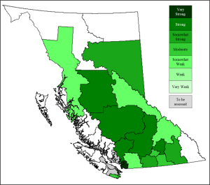
Across the province, the strength of local legislative frameworks for farmland protection vary from very strong to somewhat weak. Although local governments are required to have statutory plans and zoning bylaws that are consistent with the ALC Act to preserve agricultural land, the results of recent analyses demonstrate a high level of inconsistency. The results for assessed regional districts are shown in Figure 1.
Figure 1. Map showing strength of legislative frameworks to protect farmland for assessed regional districts
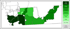
A closer look at the strength of legislative frameworks in the Lower Mainland are not consistent between the two regional districts and their member municipalities. This area of the province has very productive agricultural lands but must also contend with very high pressure from urban development. The results in Table 1 (and Figure 2) show that the strength of the legislative frameworks for the two regional districts are different, as are the strengths of frameworks among its member municipalities. These inconsistencies highlight the need for a greater level of required integration across jurisdictions.
Table 1. Strength of legislative framework: Metro Vancouver and Fraser Valley Regional Districts
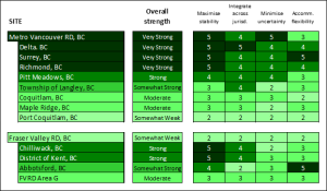
Figure 2. Strengths of municipal legislative frameworks: Lower Mainland
Appendix. Four principles for a strong legislative framework
|
Maximise stability A stable legislative framework is one that makes a clear, legally-enforceable commitment to protect agricultural land. This commitment should be firmly established in statutory plans and steady in purpose. For example, “to protect agricultural land” is a strong, clear, and direct statement; “support agricultural uses of agricultural land” is moderate; and “support agriculture” is helpful, but weaker. The location in the document of the most important statements also contributes to stability. Generally, statements at the front end of a plan are important for expressing broader, over-arching public priorities, including a long-term vision and goals for land use planning. Where agriculture is a dominant feature of the landscape and economy, it is important to acknowledge the role of agriculture at the outset. Issues and driving concerns (e.g., loss of farmland and urban development pressures) should also be included. To maximise stability, the statutory plan warrants a policy section dedicated to agricultural land that includes goals and objectives to protect farmland and support agriculture. In a high quality legislative framework, a statutory plan is supported by zoning and other implementing bylaws. Jurisdictions with areas that include a significant portion of contiguous agricultural land should consider adopting a sub-area plan (i.e., agricultural area plan), which can provide more detailed goals, objectives, and policies for a geographically-limited agricultural area. In addition, a clear commitment expressed in the statutory plan should be substantiated by enforceable policies, such as an agricultural strategy, agricultural land use inventory, and food security strategy, all of which would include additional details such as a sector profile, statistics, maps, and action plans.
|
|
Integrate public priorities across jurisdictions Integrating public priorities across jurisdictions is about one government formally aligning its commitment to protect agricultural land with similar priorities of other levels of government. For example, a local government should include a dedicated section within its statutory plan (and other relevant documents) that explicitly explains how its commitment to protect agricultural land aligns with provincial interests to protect agricultural land. Three factors influence how a commitment to protect agricultural land can be aligned with broader public priorities. First, senior governments often require lower-level government bylaws “to be consistent with” or “to conform to” upper-level legislative frameworks. Second, a local government’s authority over land use planning is affected by the extent to which senior levels of government retain (or delegate) approval of local government statutory plans and implementing bylaws. Third, if there is room for discretion, a local government may express its interest in protecting agricultural land in a way that exceeds minimum requirements. For a local government, an expression of integration can range from a single sentence that demonstrates consistency in general terms (weak) to a detailed statement that demonstrates consistency with agricultural land use policies (strong). However, if an upper-level government has a weak legislative framework, there is limited benefit for a local government to integrate. The principle of integration also applies horizontally with other municipal or regional governments at the same level, as well as with agencies working with the government. Continued on next page |
|
Minimise uncertainty A local government’s commitment to protect agricultural land should not be compromised by its other priorities or land use policies, especially policies related to urban development. Threats of non-farm development can be minimised through urban growth management policies that include designated urban growth boundaries and density targets. This commitment must be clear, direct, and integrated with other policies to help direct future development to urban areas. A review of the urban growth boundary should include a timeline for review, a mechanism to change the boundary, and target thresholds (e.g., based on population projections, estimates of land supply/capacity, and combinations thereof) that will trigger changes when conditions are met. Explicitly linking urban growth management to protecting agricultural land reinforces the mutual benefits of the two policies. Ambiguous language and open-ended conditions can contribute to uncertainty by undermining a commitment to protect agricultural land. Ambiguous language appears in different forms. Qualifying terms are those included at the end of a sentence, usually preceded by a comma. For example, a government may state its goal as “To protect farmland, whenever feasible.” These types of qualifiers raise questions regarding intent, signifying loopholes that can support the conversion and alienation of farmland. Similarly, the use of an unspecified qualifier for agricultural lands, e.g., “to protect viable agricultural land,” introduces uncertainty. Beneficial practices include policy tools, such as covenants and designating specific areas for future development under pre-defined conditions, and clear restrictions regarding non-farm activities in agricultural areas. Recognising “right to farm” legislation is also very important.
|
|
Accommodate flexibility The principle of accommodating flexibility is concerned with how known or new needs and interests are addressed alongside a commitment to protect agricultural land. Thus, this principle recognises that policies that accommodate non-farm development may be justified when a need for alternative uses is substantiated. Importantly, a government should consider how it might accommodate flexibility within its legislative framework only after it addresses the other three principles. An important means to accommodate flexibility is through governance mechanisms, such as agricultural advisory committees. Governance mechanisms, in conjunction with associated tools (e.g., agricultural impact assessments), ensure that agricultural voices and interests are represented in the decision-making process. Agricultural impact assessments should be required when considering non-farm developments that affect agricultural land and farming activities. Several other beneficial practices can be employed to accommodate flexibility. Edge planning addresses farm/non-farm interface areas that are vulnerable to conflicts by using planning techniques (e.g., buffers and setbacks). The BC Ministry of Agriculture has produced a comprehensive guide to edge planning. Development permit areas help to accommodate flexibility by designating geographic locations that need special treatment for certain purposes, such as edge planning. Source: Connell, David J. (2020). “Protecting Farmland: Principles and Beneficial Practices.” Plan Canada, 60(1): 8-12. [On-line by paid subscription]
|
Media Attributions
- Figure 1. Map showing strength of legislative frameworks to protect farmland for assessed regional districts © David Connell is licensed under a CC BY (Attribution) license
- Table 1. Strength of legislative framework: Metro Vancouver and Fraser Valley Regional Districts © David Connell is licensed under a CC BY (Attribution) license
- Figure 2. Strengths of municipal legislative frameworks: Lower Mainland © David Connell is licensed under a CC BY (Attribution) license
- N. Hofmann, “Urban Consumption of Agricultural Land,” Rural and Small Town Canada Analysis Bulletin, 3.2 Catalogue No. 21-006-XIE (Ottawa: Statistics Canada, September 2001). N. Hofmann, G. Filoso, and M. Schofield, Rural and Small Town Canada Analysis Bulletin, 6.1 no. 21-006-XIE (Ottawa: Statistics Canada, 2005). Statistics Canada, Human Activity and the Environment: Agriculture in Canada, no. 16-201-X (Ottawa: Statistics Canada, Environment, Energy and Transportation Statistics Division, 2014) ↵
- Curran, Deborah. British Columbia’s Agricultural Land Reserve: A legal review of the question of “community need”. Vancouver: SmartGrowth BC, 2007: 5. ↵
- Smith, B. (1998). Planning for Agriculture. Burnaby, BC: Agricultural Planning Commission. ↵
- Agricultural Land Commission (n.d.). Agricultural Capability & the ALR Fact Sheet. Burnaby, BC: Agricultural Land Commission. ↵
- Connell, D. J., and L. A. Daoust-Filiatrault (2012). "Better Than Good: Three Dimensions of Plan Quality." Journal of Planning Education and Research, 1-8. ↵

Feedback/Errata