Case. Kemess North: Rights, Title, and Subsurface Resources
NATURAL RESOURCES PLANNING CASE STUDY
Learning Objectives
Unceded traditional territories
British Columbia (BC) boasts considerable subsurface resources, including coal, gold, copper, industrial minerals (sulphur, silica, etc.), and construction aggregates (gravel, sand, limestone, etc.). Consequently, there are major mines operating throughout the provincial land base, with hundreds of smaller aggregate and seasonal mines. According to the Mining Association of British Columbia, the mining sector employs directly and indirectly more than 35,000 people and contributes $18 billion to the provincial economy. Offsetting the benefits of economic development, the exploration and extraction of these mineral resources has had profound influences on the province.
The Province of British Columbia, like other provinces, owns all subsurface rights, including the rights to access to minerals, natural gas, and petroleum resources. Rights to access these resources are referred to as subsurface property rights. Various laws and regulations govern how the province may dispose these rights to others.
When Northgate Minerals Corporation proposed to develop the Kemess North copper/gold mine in 2003, everyone expected that this project would be approved. The first sign that the outcome might be different appeared when a joint Federal-Provincial panel review was announced in 2004. At the time, these joint reviews were the most comprehensive assessment procedures practised and, prior to Kemess North, had never been used when conducting a mine assessment in BC. As it turned out, the panel’s recommendation was also unprecedented in BC: the project was not approved as proposed.
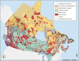
While Kemess North is a milestone case for recognising Indigenous interests through an assessment process and an inspirational tale of environmental justice, the case also highlights fundamental shortcomings involved in asserting Indigenous title and rights to subsurface resources on a project level. It is critically important to acknowledge that natural resource developments occur not only on Crown land—but on the traditional territories of Indigenous Nations, as evident in the following map (Figure 1).
Figure 1. Location of mineral claims in relation to Indigenous lands across Canada
In the past, natural resource planning was considered a matter of land use planning for Crown lands. Indigenous Nations were considered only as stakeholders, as opposed to a government. Yet much has changed over the past few decades as Indigenous title and rights have been recognised incrementally and increasingly through Canada case law decisions. Moving forward, natural resource planning can only be viewed as a joint planning process between the Federal or Provincial governments and Indigenous Nations. That is, natural resource planning must be viewed as government-to-government land use planning.
This lack of recognition of Indigenous rights is embedded in the “free entry” system that is the foundation of BC’s subsurface property rights regime. The “free entry” system is the term used to describe the process to obtain rights from the province to subsurface minerals. This system, under the Mineral Tenure Act ([RSBC 1996] Chapter 292), enables almost any person to apply for a mineral claim almost anywhere in BC. All one has to do is apply for Free Miner Certificate, pay the fee, and register their claim on line through the BC Mineral Titles Branch. A claim can then be issued without either the claim owner or the government contacting the owner of private land or an Indigenous Nation of unceded traditional territory. No consultation or consent is required.
In 2021, the Gitxaala Nation sued the Province of British Columbia over the free entry system (Box 1). In September, 2023, the BC Supreme Court ruled that the province’s mining permit system is not in compliance with the government’s duty to consult Indigenous groups. The province was given 18 months (until March, 2025) to introduce a new system.
Box 1. ‘Free entry’ system challenged in court by Indigenous Nations
Amid these questions and concerns about rights to subsurface resources, the lack of formally recognised regional land use plans that accommodate multiple interests has implications for all parties. In particular, regional land use planning, if done well, is widely considered as a potentially important, if not essential, mechanism for recognising and asserting Indigenous title and rights over traditional territories.[4] In the absence of joint land use plans between the Province and Indigenous Nations, the joint environmental assessment panel decision applies only to the project as proposed to the panel, so the potential exists for similarly controversial development proposals—and the need to start a new review process.
The Kemess North Copper-Gold Mine Project
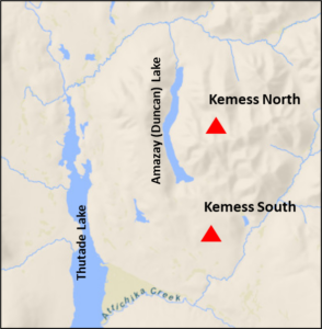
Between 1998 and 2011, Northgate operated the Kemess South Mine (mineral lease # 354991). In 2001, exploration activities revealed substantial mineral deposits in an area approximately five kilometres north of the existing mine site.[5] The bid to develop these deposits would eventually become known as the Kemess North Project.
Perspective: Kemess North Participant
The Kemess South mine was controversial for the communities. Blockades went up. But the lack of public support behind their opposition resulted in very cornered communities. Ultimately the mine went through.
Source: Anonymous (personal communication, June 20, 2010).
The Kemess North mine site is part of an area owned by Kemess Mines Ltd., a subsidiary of Northgate Minerals Corporation.[6] The Kemess property, shown in Maps 1 and 2, covers roughly 34,000 ha in north-central BC, approximately 430 km northwest of Prince George. Large portions of the Kemess property were given to Northgate as compensation for the expropriation of the Windy Craggy mineral rights during the creation of Tatshenshini-Alsek Provincial Park. Northgate owns surface rights to the entirety of the property, as well as to two inactive mineral leases (#410732, #410741). It also has registered 206 mineral claims.
Map 1. Kemess Property Location in BC
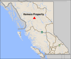
The Kemess Property and its associated mineral tenures overlap with the traditional territories of the Fort Connelly First Nation, Gitxsan House of Nii Kyap, Kwadacha First Nation, Takla Lake First Nation, and Tsay Keh Dene First Nation (hereafter the ‘Five Nations’)[7].
Map 2. Kemess North and South Mine Locations
Mackenzie Land and Resource Management Plan
As part of province-wide regional planning (Box 2), the Mackenzie Land and Resource Management Plan (Mackenzie LRMP)[8] was initiated in 1996 and ratified in 2000, a seemingly ideal timeframe to anticipate and resolve potential land use conflicts associated with the Kemess North mine. The Kemess Property is contained entirely within the Mackenzie LRMP. However, both the Mining Association of British Columbia and (most) Indigenous groups were notably absent from the Mackenzie LRMP process.
Box 2. Regional land use planning in BC
Learning Module
In 1999, industry representatives from the mining sector withdrew from the Mackenzie LRMP process after “conclud[ing] they could not achieve their goals and objectives by going through collaborative approaches.”[9] This ambivalence is at least partially explained by section 14(5) of the Mineral Tenure Act, where “a land use designation or objective does not preclude application by a recorded holder for any form of permission, or approval of that permission, required in relation to mining activity.” Therefore, unless the Kemess property was designated as a protected area—in which case Northgate would have a strong argument against expropriation—the LRMP process has little bearing on access and exploratory rights afforded under the free entry system. In the absence of the Mining Association, mineral interests were represented by provincial agencies at the planning table.
Learning Modules
The Kwadacha was involved throughout the Mackenzie LRMP as a full table member, a designation that treats Indigenous representatives as equivalent “stakeholders” to other resource interest groups. The relegation of Indigenous interests to stakeholder status falls well short of the preferred government-to-government interactions that are advocated in contemporary planning practices. For these (and other) reasons, the Tsay Keh Dene declined participation, but did submit an independently produced Land and Resource Conservation Management Plan, which is attached as an appendix to the Mackenzie LRMP.
In relation to Kemess North, a relevant sub-area of the Mackenzie LRMP is the Thutade Resource Management Zone (RMZ). The sub-area is designated as a Mining and Wildlife Special Resource Management Zone, as follows.
The intent of this zone is to manage for the conservation of non-extractive values such as wildlife and wildlife habitat, fish and fish habitat, heritage and culture, scenic areas, recreation and tourism. This zone also has a special emphasis on mineral development and related access. Opportunities are maintained for timber, mineral and oil and gas development.[10]
The RMZ objectives related to mineral development are to:
- promote development of high mineral values and recognise the significance of mineral potential in this zone; and
- maintain opportunities for mineral exploration, development and transportation.
While the RMZ acknowledges the numerous overlapping Indigenous land claims in the Thutade area, noting that “it seems likely that [this] was an important area for cultural diffusion,” the specific traditional uses are described as “relatively undocumented.”[11] Consequently, the RMZ contains no objectives related to preserving Indigenous values.
Mackenzie LRMP’s Effect on Recognising Indigenous Rights
The general management direction for the Mackenzie LRMP declares, “nothing in this Land and Resource Management Plan is intended to create, recognize or deny any aboriginal rights” and advocates that planning occur “co-operatively with aboriginal peoples to address their rights and interests” through management strategies designed “to minimise the effects of development on First Nations traditional and historic uses.”[12] However, the LRMP does not clarify how Indigenous objectives will be integrated into overall management strategies, implemented, or monitored. Furthermore, only Indigenous groups with established settlements within the planning boundaries were invited to participate in the LRMP process, leaving the traditional territories of many Indigenous peoples, including those impacted by Kemess North, vulnerable to land use decision-making beyond their control. It is notable that the boundaries for the Mackenzie LRMP and the Tsay Keh Dene conservation plan are not harmonised.
Perspective: Kemess North Participant
I’m not sure if the LRMP process respected title at all. Rights may have been partly protected, but only where a community was willing to avoid assertion of title. A land-use planning process will only function respectfully and result in consensus if the foundation of the process is grounded in recognition of title and rights. To date, few if any processes are willing to do this, as government legal-advice consistently seeks to avoid any and all recognition of aboriginal title at an operational level. This is likely for fear of handing over authority. In my opinion, what the Crown fears most is having to add more protected areas to our province, and subsequently compensate mining companies for withdrawal of tenures, and secondly, having to meaningfully collaborate at the operational level in regards to monitoring/approving future projects.
Source: Anonymous (personal communication, June 20, 2010).
The Tsay Keh Dene conservation plan also articulates the need for “Tsay Keh Dene involvement in determining future development and access” for mining, logging, and road construction.[13] Although the conservation plan makes no specific mention of Amazay Lake, the plan refers to the significance of nearby Thutade Lake, where objectives related to conservation of fish and wildlife habitat are relatively consistent with the Thutade RMZ.
Perspective: Chief John Allen French, Takla Lake
Consultation and Environmental Assessment Review
The consultation process for a mining project begins with a Notice of Work application. Under certain conditions,[15] an environmental assessment is required, which establishes a comprehensive process of consultation.
Notice of Work
Initial consultation for the Kemess North deposit began with the exploration referral process, where affected parties receive a Notice of Work (NOW) from project proponents and are granted 30 days to comment on the proposed project locations, schedules, and mitigation measures. For Indigenous groups, responding to a NOW involves the completion of a traditional-use assessment, which describes how a project will affect Indigenous rights. Many Indigenous groups, particularly in Northern BC, are overwhelmed with referrals and are unable to adequately respond within the “brutal” time frame afforded.[16] This problem is exacerbated by the generalised nature of NOW referrals, which often fail to provide the details necessary for a thorough assessment of potential project impacts. Furthermore, in the case that an Indigenous group is able to respond to a NOW within the allotted timeframe, critics argue that of Indigenous opposition to NOWs is often ignored.[17] In the case of Kemess North, this initial consultation process did not capture the concerns of affected Nations. An extensive exploratory drilling program was conducted from 2001-04.
Environmental Assessment
In 2003, Northgate officially submitted its pre-application environmental assessment proposal for Kemess North with provincial authorities. Under the Public Consultation Policy Regulations of the BC Environmental Assessment Act (2002), a proponent was required to conduct and document a “public consultation program that is acceptable to the executive director.”[18] Despite the fact that there is no common law duty on proponents to consult with Indigenous peoples, most proponents find motivation to voluntarily consult with impacted peoples, an expensive and time-consuming task which may serve to improve public relations, exhibit corporate social responsibility, flow benefits to Indigenous peoples, or proactively resolve land use conflicts.
In 2004, Northgate and the Five Nations signed a Statement of Understanding (SOU), which in turn laid the foundation for negotiations on a Consultation and Negotiation Protocol. The protocol was designed to address compensation measures, employment contracts, revenue sharing, and impact benefit agreements. Northgate’s estimates of socio-economic benefits (Box 3) and compensations (Box 4) were included in these discussions.
Box 3. Estimated Socio-economic Benefits
- 350 full time workers until 2020;
- 125 additional contract positions;
- 150 jobs during construction;
- $191 M annually in provincial royalties.
Source: Kemess North Joint Review Panel [EAO] (2007).[19]
Box 4. Highlights of Northgate’s Proposed Consultation and Land Claims Accommodation Agreement
- 75 meetings over 4 years;
- $450,000 in funding for participation in review process;
- Compensation for trapline holders;
- Minimum annual payments of $1M to affected communities;
- Interest in profits generated by the mine;
- Continuation of job training program, which has successfully employed 70 First Nations at Kemess South (17% of workforce).
Source: Ken Stowe, President and CEO, Northgate Minerals Corporation[20]
Whereas the affected Nations initially supported the Kemess North proposal, chiefly because of the purported socio-economic benefits that would result from its development, they eventually mounted a full opposition to Northgate’s proposal. The disagreement stemmed from the company’s preferred method of disposal for waste acid mine tailings, which involved indefinite containment in pristine Amazay (Duncan) Lake:
Northgate Minerals is proposing to destroy Amazay (Duncan Lake) to make a waste dump for its Kemess North mine.… Amazay Lake is part of our territory and is an important place to our people. Amazay means “little mother.” We believe it is a birthing place for animals that are important to us. It is a place that we have used, managed, and protected since time immemorial.[21]
Negotiations for the protocol agreement lasted six months, but reached an impasse when it became increasingly clear that Amazay Lake was the only option for tailings impoundment.[22] This provision was unacceptable to the Five Nations, who signed the SOU with the explicit understanding that alternative waste disposal options would be thoroughly considered during the environmental assessment process.
While the Five Nations continued to voice their opposition, Northgate persisted in “intimating to environmental assessment regulators that it had the support of First Nations to continue to pursue the lake as an option.”[23] Subsequently, the Consultation and Negotiation Protocol was abandoned, with the Five Nations opting instead to focus upon the constitutional obligations of the provincial and federal governments to consult. As expressed by affected Indigenous peoples,
Currently, our territory is under threat from mining, logging and other industrial activity. We do not oppose development. We need jobs, training, and revenue for our people. However, we do not support unsustainable development that destroys our lands and waters.[24]
Crown Consultation
Whereas private corporations are not specifically required to consult with Indigenous peoples independently of the overall public review process, the Crown’s duties to consult and accommodate are firmly entrenched in common law. Current interpretations suggest that “the duty arises when the Crown has knowledge, real or constructive, of the potential existence of the Aboriginal right or title and contemplates conduct that might adversely affect it.”[25] Accordingly, the provincial duty to consult was triggered in 2003, upon receiving Northgate’s pre-application notice; the federal duty was initiated in 2004 upon the pronouncement that Fisheries and Oceans Canada would be involved in the environmental assessment. Common law has not prescribed a process for “meaningful consultation,” thus providing the Crown considerable flexibility in fulfilling its obligations.
For Kemess North, despite repeated requests by the Five Nations to establish a formal consultation agreement with the Crown, it was decided that Indigenous interests would be primarily addressed through a joint panel environmental assessment review. Joint panel reviews are the most comprehensive assessment procedures currently practised, and, prior to Kemess North, had never before been used when conducting a mine assessment in BC. In addition, one of the three panel members was appointed by the Five Nations representatives. Nevertheless, concerns remained outstanding.
In their submission to the Kemess North Joint Review Panel, Indigenous representatives argued, “[t]he federal and provincial environmental assessment processes are not the proper processes for determining and addressing potential impacts to Aboriginal title and rights and are…unable to meaningfully engage First Nations with regard to identifying potential impacts and determining appropriate accommodation measures.”[26] Their argument rested upon the following limitations of the joint assessment process:
- the process lacks the mechanisms for substantive consultation;
- it does not engage participants at strategic planning levels;
- it provides insufficient funding for third party assessments; and,
- it summarises and interprets public comment before inclusion in a final report.
Tse Keh Nay and the Joint Panel Review
In 2006, the Kwadacha, Tsay Keh Dene, and Takla Nations formed an alliance, collectively called Tse Keh Nay[27].
In lieu of a formalised consultation agreement with Northgate or the Crown, and seeing few remaining prospects for conserving Amazay Lake, Tse Keh Nay opted to participate in the environmental assessment under protest. From the onset, however, it became clear that the process would be decidedly unconventional. Prior to the panel review, the Tse Keh Nay were instrumental in conducting numerous public relations campaigns that helped to inform the public about the severity of the mine’s environmental impact. The opening panel hearings consisted of an elaborate pipe ceremony, complete with a poignant testimonial from Takla Chief John Allan French, the content of which was included in official transcripts of the review process only because the Tse Keh Nay insisted. At a later panel hearing, to resolve funding disparities and collate additional information, the Gitxsan successfully passed a motion to suspend panel hearings, with an extension granted at the behest of the Tse Keh Nay. Finally, during winter 2006, Tse Keh Nay representatives organised a site visit for panel members to the remote, frozen Amazay Lake, where Indigenous leaders could more tangibly communicate their cause for concern.[28]
For their part, the panel review members also displayed a unique approach to the review process. In addition to Northgate’s 2004 feasibility study, the panel ordered two independent feasibility assessments, which would eventually conclude that the proposal was “not economically robust” and project benefits were “marginal.”[29] The panel also chose to adopt what was coined a “sustainability assessment framework,” where panel members reviewed each of the project stages in terms of (1) environmental stewardship; (2) economic benefits and costs; (3) social and cultural benefits and costs; (4) fairness in the distribution of benefits and costs; and (5) present versus future generations.
Joint Review Panel Recommendation
After 11 months of contentious dispute, suspended hearings, and countless inputs of human resources, the panel reached its recommendation, as follows.
The Kemess North Mine Joint Review Panel has concluded that development of the Kemess North Copper/Gold Project in its present form would not be in the public interest .… The Panel recommends to the federal and provincial Ministers of the Environment that the Project not be approved as proposed .… Key adverse effects include the loss of a natural lake with important spiritual values for Aboriginal people, and the creation of a long-term legacy of environmental management obligations at the minesite to protect downstream water quality and public safety.[30]
The panel’s recommendation, unprecedented in BC, was highly contested by Northgate officials, who declared that “[s]uch a conclusion does not appear to be shared by any of the federal and provincial departments who have reviewed this and many other similar projects and found the risks to be acceptable.”[31] Northgate called the decision “a deep disappointment for the Canadian exploration and mining community.”[32] In spite of a persuasive public relations campaign by Northgate to reject the panel’s recommendation, the provincial and federal agencies upheld the panel’s verdicts.
In March 2010, Northgate submitted a second Notice of Work proposal to continue exploration at Kemess North with the intention of developing a “smaller footprint” underground mine in the same area.[33]
Perspective: Kemess North Participant
It seems to me that each and every provincial process is standing on only one leg, and is therefore sensitive to any and every land-use conflict. Current provincial land designations could easily be thrown out of court for failing to meaningfully consult and accommodate First Nations. I see the remedy for this lies in granting the right of full consent to each and every project. Will this result in some projects not moving forward? Yes. However, I would expect that many more projects would move quickly because the government and industry would have to come to the realization that they are partners in the planning and the decisions, not final arbiters.
Source: Anonymous (personal communication, June 20, 2010).
According to JP Laplante, the former Mining Coordinator for Takla Lake Nation,[34] the Kemess North project underscores the need for joint land use planning between Indigenous peoples and the provincial government.
The human resources required at the community and leadership level to engage in a battle such as the Kemess North are significant. The time and energy dedicated to this battle could have been directed to other areas such as community development, education, health, housing, and other community priorities.[35]
Laplante believes that landscape-level land use plans could minimise conflict and work toward harmonising development goals of all parties. Such agreements may include provisions for a preferred consultation protocol or policy related to mineral development.[36] Specific policies can include land use plans that are the result of reconciling existing provincial and Indigenous land use plans or of a new joint planning exercise.
Media Attributions
- Figure 1. Location of mineral claims in relation to Indigenous lands across Canada © International Boreal Conservation Campaign and Canadian Boreal Initiative is licensed under a All Rights Reserved license
- Map 1. Kemess Property Location in BC
- Map 2. Kemess North and South Mine Locations
- In 1959, the North Takla Band and the Fort Connelly Band amalgamated to form Takla Lake First Nation. ↵
- Charlebois, B. (April 3, 2023). “Gitxaała First Nation slams B.C.'s 'outdated' mineral rights system in court challenge over consent,” The Canadian Press. ↵
- Gitxaala v. British Columbia (Chief Gold Commissioner), 2023 BCSC 1680. ↵
- Clogg, Jessica (2007). Land Use Planning: Law Reform. West Coast Environmental Law, p. 1. ↵
- Gray, J H., R J. Morris, A Arik, and F C. Edmunds (2005). "Technical Report – Revised Mineral Reserve and Resource: Kemess North Project." GR Technical Services, p. 4. ↵
- Refer to the case Updates for recent developments at this mine site. ↵
- The names of these Indigenous groups are the names used in formal submissions during the environmental assessment process. ↵
- Integrated Land Management Bureau [ILMB] (2001). Mackenzie Land and Resource Management Plan. Province of British Columbia. ↵
- Gunton, Thomas I., Thomas Peter, and J C. Day (2006/07). "Evaluating Collaborative Planning: A Case Study of a Land and Resource Management Process." Environments 34(3): 26. ↵
- ILMB (2001), p. 159 ↵
- ILMB (2001), p. 160. ↵
- ILMB (2001), p. 102. ↵
- ILMB (2001), p. 350. ↵
- Takla Chief John Allen French, as quoted in: Place, Jessica (2007). Expanding The Mine, Killing A Lake: A Case Study Of First Nations' Environmental Values, Perceptions of Risk and Health. (The University of Northern British Columbia), p. 21. ↵
- For BC, refer to information about the Reviewable Projects Regulation ↵
- International Human Rights Clinic [IHRC] (2010). Bearing the Burden: The Effects of Mining on First Nations in British Columbia. Cambridge, MA: Harvard Law School. ↵
- IHRC (2010), p. 71. ↵
- Public Consultation and Policy Regulations, 4(1)(a). ↵
- Kemess North Joint Review Panel [EAO] (2007). Kemess North Copper-Gold Project Environmental Impact Assessment Report. Victoria, BC: BC Environmental Assessment Office. ↵
- Stowe, Ken (2007). "Comments on Kemess North." Northgate Minerals Corporation. ↵
- Littlefield, L., L. Dorricott, and D. Cullen (2007). Tse Keh Nay Traditional and Contemporary Useand Occupation at Amazay (Duncan Lake): A Draft Report. Submission to the Kemess North Joint Review Panel, p. 1. ↵
- First Nations Summit (2006). Say ‘No’ to the Total Destruction of Amazay Lake. Submission to the Kemess North Joint Review Panel, p. 30. ↵
- First Nations Summit (2006), p. 30. ↵
- Littlefield et al. (2007), p. 1. ↵
- Haida Nation v. British Columbia (Minister of Forests), 2004 SCC 73. Also: R v Sparrow, [1990] 1 S.C.R. 1075; Delgamuukw v British Columbia, [1997] 3 SCR 1010; Tsilhqot'in Nation v British Columbia, [2014] SCC 44. ↵
- First Nations Summit (2006), pp. 14-15. ↵
- In various documents, Tse Keh Nay is often referred to as TKN. ↵
- For a more nuanced discussion of the Kemess North timeline, see former Takla Lake Mining Coordinator J.P. Laplante’s astute summary "Kemess North: Insights and Lessons." Takla Lake First Nation (2009). ↵
- Laplante (2009), p. 9. ↵
- Kemess North Joint Review Panel (2007). "Kemess North Copper-Gold Mine Project: Joint Review Panel Executive Summary." British Columbia Environmental Assessment Office, p. 1. ↵
- Stowe, Ken. "Comments on Kemess North." Northgate Minerals Corporation. ↵
- Jepsen, Dan M (2006). "Kemess North and the Road to Sustainability." Association for Mineral Exploration British Columbia. ↵
- Canadian Environmental Assessment Registry (2010). "Submission for the public hearings regarding Kemess North." Refer to the case Updates for more information. ↵
- Laplante (2009), p. 37. ↵
- Laplante (2009), p. 19. ↵
- Such a mining policy has been successfully developed by Taku River Tlingit First Nation. ↵

Feedback/Errata