Case. Planning for Agriculture: Land, Food, and Community Need
AGRICULTURAL LAND PLANNING CASE STUDY
Learning Objectives
This case explores agricultural land use planning by examining the interrelationships among provincial, regional, and municipal planning measures that influence British Columbia’s agricultural landmis and agricultural sector. This case is guided by over-riding questions about the public interest in protecting agricultural land to produce food for domestic consumption and export. Students are encouraged to identify trends in legislation, policy, and practices that may influence agricultural production in the future, either negatively or positively. Particular emphasis is to be paid to:
- BC’s provincial interest in protecting agricultural lands;
- the role of local governments; and,
- specific challenges and opportunities facing the agricultural sector.
Is food production merely another resource-based industry equivalent to other provincial stalwarts like forestry, mining, or oil and gas? Perhaps our farms are nothing more than urban lands-in-waiting, patiently anticipating favourable market conditions to transform them into profitable residential or industrial areas. Or maybe, as some have suggested, agriculture is something entirely different—a “use of priority” where agricultural lands are protected from other uses, and farm viability is supported through economic policies and programs.[1] The answer may be deduced by first asking, “Who needs agriculture?”
Agriculture, food, and Canadian society
The question about the need for agricultural land concerns “the nature of society we want, the place in it for farmers, the food policy we are comfortable with and the price we are willing to pay to obtain these important goals.”[2] These needs and wants have changed during Canada’s history. The first national interests in agriculture centred on immigration and agricultural settlement as a means to increase the population of Canada’s frontier and the development of its rural economy[3], , all of which were embedded within the process of colonisation.
The direction of development changed dramatically in the 1940s. The impacts of mechanical and chemical inputs led to an intense wave of farmland abandonment in some areas and amalgamations in others[4]. From the post-war period to the late twentieth century, agricultural policy centred on state assistance in the belief that agriculture remains an exceptional sector that provides public goods that the market alone could not achieve.[5] The seeds of another shift in agricultural policy were planted in the 1969 Report of the Federal Task Force on Agriculture, which promoted moving away from a “public good” concept of agriculture to a focus on free enterprise and competitiveness.[6] In 2017, the Economic Advisory Committee to the Federal Government identified the agri-food industry as a “key sector” for national economic growth with a goal to become the world’s second largest exporter of agri-foods.[7]
The future of Canadian society will continue to be profoundly influenced by agriculture’s development and adaptation to shifting domestic and global drivers, including market volatility, urbanisation, climatic disruptions to global food supplies, and growing demand for local food and farmland amenities. At the same time, the nationally significant and localised nature of agri-food issues, whether in inner cities, peri-urban areas, or Indigenous territories, points to the need for co-ordination among and across multiple jurisdictions.
Land use planning seeks to minimise conflict in the pursuit of an appropriate balance of land uses. Therefore, it is incumbent upon practitioners and decision-makers to consider the relationship between agricultural land uses and the mosaic of competing land uses that exist across the province.
The political context today
Within British Columbia (BC), and elsewhere across Canada, a historical decline in the economic and social role of agriculture during the post-war era corresponded with a significant loss and degradation of the prime agricultural land base.[8] Prime agricultural land refers to land with high capabilities for food production. Capability is classified by the BC Land Inventory (BCLI) system, whereby Classes 1, 2, and 3 are considered “prime.” “Productive” agricultural land includes Classes 1 to 4. The BCLI is based on the Canada Land Inventory (CLI) (see Box 1).
The most highly productive land base in BC faces growing pressures from urban development and the pursuit of other economic priorities, with few indications that this trend will be curtailed significantly. As well, the rights and capacities of farmers to use agricultural lands are compromised increasingly by neighbouring non-farm uses, such as when residential neighbours file unwarranted nuisance complaints about farm odours and noise, or sever residential lots near agricultural operations.
As a land use policy, protecting agricultural land first garnered serious public attention in Canada in the early 1950s with most provincial and local jurisdictions having some form of legislation or guidelines in place by the end of the 1970s. Connell et al. provide a comprehensive account of farmland protection policies across Canada.[9] However, despite efforts over the past fifty years, Canada has experienced a continual loss of prime farmland.[10]
Farmland protection policies have been accompanied by an “array of economic, environmental, and social conflicts [that] characterise the tension between urban, recreational, infrastructure, and industrial land uses, and viable rural or agricultural communities.”[11] Correspondingly, motivations to protect farmland are influenced by factors such as food production, market value for land, environmental issues, rural landscape amenities, agrarian ideals, and land use conflicts on the urban fringe.
In addition to a desire to protect farmland, two other policy regimes influence the use and perceived value of agricultural land. A policy regime of global competitiveness has strengthened over the past fifty years at both the national and provincial levels. A recent report on competitiveness by the House of Commons Standing Committee on Agriculture and Agri-Food focussed on access to new markets, barriers to trade, food safety and product labelling, and market concentration within sectors.[12]
More recently, a policy regime centred on food sovereignty has emerged. While the control of food supplies were among the earliest drivers of nation-building and human settlements, food sovereignty is about the right of peoples to define, protect, and regulate domestic agricultural production and land policies that promote safe, healthy, and ecologically sustainable food production that is culturally appropriate.[13] While universal in its significance, food sovereignty is of particular importance to many Indigenous Peoples of British Columbia. A food system largely shaped by Euro-Canadian perspectives is often to the detriment of the cultural traditions and health of Indigenous peoples. Food sovereignty and access to traditional foodlands are critical issues for BC’s Indigenous Peoples, as exemplified by the BC Indigenous Food Systems Network and the Indigenous Food Sovereignty Association.
Within BC, the growth of the local food movement, as evident by the increasing number of farmers markets and citizen-based initiatives like community gardens and local food councils, has been the forerunner of recent calls for citizens having greater control over provincial and national agri-food policies. Adopting agri-food policies that promote greater food sovereignty and household food security could easily reach into people’s daily lives, with economic, social, and environmental implications, both positive and negative.
BC’s Agricultural Geography
Compared to many other provinces, BC has a small agricultural land base, equating to 4.2% of the total farmed area in Canada. Of all BC lands, the following may be described as agricultural (see Box 1)[14]:
- Less than 5% of BC lands are included in the Agricultural Land Reserve;
- 1.12% of BC lands are considered prime agricultural lands (Class 1-3);
- 2.64% of BC lands are capable of producing a range of crops (Class 1-4);
- 0.06% have Class 1 agricultural capability.
Box 1. Agricultural Capability Classification in BC
Class 1 land either has no or only very slight limitations that restrict its use for the production of common agricultural crops.
Class 2.land has minor restrictions that require good on-going management practices or slightly restrict the range of crops, or both
Class 3 land has limitations that require moderately intensive management practices or moderately restrict the range of crops, or both.
Class 4 land has limitations that require special management practices or severely restrict the range of crops, or both.
Class 5 land has limitations that restrict its capability to producing perennial forage crops or other specially adapted crops.
Class 6 land is non-arable but is capable of producing native and or uncultivated perennial forage crops.
Class 7 land has no capability for arable or sustained natural grazing.
Source: Agricultural Land Commission
Despite these relatively modest figures, BC’s farmlands are indisputably diverse and economically valuable. The Province organises the land base into eight regions of major agricultural significance: Vancouver Island-Coast; Lower Mainland-Southwest; Thompson-Okanagan; Kootenay; Cariboo; North Coast; Nechako; and Peace Region. Currently, it is estimated that BC farmers produce roughly 200 different agricultural commodities. This food production accounts for roughly 48% of all food consumed within the province.[15] BC’s agriculture industry generates about $4.8 billion annually in gross farm receipts and employs 23,680 farm operators.[16]
Agricultural land can also yield many valuable ecological services, such as the provision of wildlife habitat, conservation of water and soil resources, and sensitive area protection. Moreover, many of the farmlands boast high amenity value, as evidenced by BC’s burgeoning agri-tourism industry, where consumers are increasingly enjoying direct farm marketing, orchard and winery tours, as well as low-impact recreational pursuits. Farming can also be said to have inherent heritage values, in which BC’s past and present cultural identity has been inextricably linked to the production of food.
Productive agricultural lands contribute positively toward food security. Food insecurity is a prevalent issue for BC’s proportionally large economic underclass, where 13.3% of BC children and youth (0-17) are living in poverty in 2020.[17] Furthermore, the agriculture industry is purported to have significant potential toward mitigation of climate change-inducing greenhouse gases, through emission reduction practices and carbon sequestration measures.[18]
Land Use Issues
The breadth of BC’s agriculture brings with it a host of planning challenges. Agricultural land conversion, land use incompatibility, farm viability, and climate change are some of the issues to be considered when planning for agriculture.
The loss of farmland is concerned primarily with the conversion of agricultural land for non-farm uses, such as residential, commercial, or industrial uses. The availability of agricultural land is also affected by other forms of alienation, such as fragmentation and parcelisation. Other issues are alienation of farmland through foreign ownership, tree planting for carbon credits, and pressures from natural resource developments (e.g., oil and gas, forestry, mining).
Learning Module
Land Use Incompatibility
Despite the idyllic images perpetuated in popular media, farm operations have significant potential for conflict with surrounding land uses. Although incompatibilities are often most visible at the agricultural-urban interface, other land use activities also negatively affect agricultural operations and vice-versa.
There are several factors that may influence the potential for agricultural land use conflict, including the type of farming operation, the intensity of farming operation, climate and topography, and perceptions.[19] Some of the nuisances typically associated with farming operations may include:
- odours, dust, and noise pollution;
- safety issues with livestock;
- runoff of pesticides, herbicides, and manure into freshwater bodies;
- irrigation demand; and,
- irregular or inconvenient traffic patterns (slow-moving vehicles on highways, etc.).
Conversely, farm operators in close proximity to urban, commercial, or industrial land uses may be burdened by trespass, theft, livestock harassment, invasive weeds, and other damages to property.[20]
Farm Viability
Since the first Census of Agriculture in 1931 until 2006, BC has seen a staggering decline in farm operators. Over the past 100 years, BC has moved from 1 in 7 inhabitants living on a farm to 1 in 211.[21] During the same period, the provincial population increased from fewer than 700,000 to over five million. While these dramatic changes can be explained partially by mass urbanisation and improved farming technologies, they are also the result of the underlying economic reality of farming: it is difficult for people to earn a living from farming.
- On the surface, BC’s agricultural sector may indicate a healthy, even flourishing industry. However, a closer inspection reveals several troublesome trends.[22] In 2020, while BC farms generated $4.8 billion in gross farm receipts, they also incurred $4.2 billion in operating expenses. This means that for every $1 in farm receipts earned, BC operators paid out $0.88 in expenses. Meanwhile, total agricultural operating expenses keep rising, largely caused by:
- escalating land costs due to high market demand; and,
- inflation of farm input costs consistently outpacing inflation of farm product revenues.
Furthermore, gross farm receipts statistics are artificially buoyed by increasingly large inputs from government-funded payment programs. On the upside, net farm income increased since 2016.
BC’s outlook is skewed by the disproportionate influence of large-scale operators, where 10.2% of farms account for 70% of all gross farm receipts.[23] Thus, farm viability is especially threatened for medium- and small-scale operators who are methodically being squeezed out of the market by large-scale retailers, commodity marketing boards, and inflexible provincial food inspection regulations. To supplement on-farm income, most BC farmers require “off farm” income just to stay afloat.
Finally, alarm is being raised about the lack of young people entering the agricultural industry to replace the aging farmer population. In 2020, in Canada, the average age of a farmer was 56.3 years, which increased from 49.4 in 1996. That is, the average farmer is getting older. At the same time, operations led by farmers aged 55 to 59 account for the largest share of all operations at 58.5%.[24] If this trend persists, not only will our province undergo severe declines in economic activity and food production, but also considerable—and perhaps irreplaceable—loss of agricultural knowledge.
Climate Change
Over the past century, BC’s climate has changed. According to a Pacific Institute for Climate Solutions report, “The science to date is unequivocal”:
- the average annual temperature increased 1.2°C (between 0.5 and 1.5°C by region);
- annual precipitation increased, on average, by 22% (between 10 to 50% by region), with the greatest increases in winter and spring;
- more heavy rainfall events in the spring;
- increase in both extreme wet and extreme dry conditions in summer; and,
- increase in extreme hot and decrease in extreme cold temperatures.[25]
The same report also highlights expected changes for temperature and precipitation in BC:
Temperature
-
- continue warming trend;
- greater warming in north than south, inland than coastal, winter than summer; and,
- increasing frost free days and growing degree days.
Precipitation
-
- continuing increase in average annual precipitation;
- increase in precipitation in fall, winter, spring; decrease in summer;
- significant decrease in winter and spring snowfall in most regions; and,
- increasing proportion of precipitation falling as rain rather than snow in most areas.[26]
Climate change will have both negative and positive impacts for BC farmers. One of the chief impediments to reaping the purported benefits of climate change at a local level is irrigation infrastructure and availability of freshwater. At a global scale, changes in global food supply are certain to effect BC’s agricultural sector. Furthermore, climate change models suggest far greater uncertainty. While average temperature and precipitation regimes may favour food production, an increase in climatic variability poses substantial risks to producers. And while farmers are adept at coping with environmental hazards such as flood, drought, salination, invasive plants, pest outbreaks, and wildfires, it is expected that the frequency of such events will increase.
Planning for Agriculture across Jurisdictions
Reconciling competing interests for agricultural lands remains a complicated process that crosses multiple jurisdictions. Under Section 95 of Canada’s Constitution Act, 1867, responsibility for agriculture is jointly shared by the federal and provincial governments. However, responsibility for land use planning rests with provinces. Local responsibility for land use planning is the result of the provinces delegating certain areas of decision making to the local level, with varying degrees of provincial oversight.
The legislative framework for agricultural land use planning in BC is shown in Table 1. The Agricultural Land Commission (ALC) and the Ministry of Agriculture[27] are the primary government agencies that exercise jurisdiction over farm land uses. These agencies must work in concert with a variety of federal (e.g., Canadian Food Inspection Agency), provincial (e.g., BC Farm Industry Review Board), regional, and municipal bodies, industry representatives (e.g., BC Agricultural Council, BC Cattlemen’s Association), Indigenous Nations (e.g., First Nations Agricultural Organization), and public organisations (e.g., Farmers Institutes) to effectively carry out their mandates.
Table 1. Legislative Framework for British Columbia
|
|
POLICY |
LEGISLATION |
GOVERNANCE |
|
PROVINCIAL |
Agricultural Land Commission policies Bylaw Review Guide Guide for Bylaw Development in Farming Areas (AGRI, 2015) Guide to Edge Planning |
Agricultural Land Commission Act Local Government Act Farm Practices Protection Land Title Act Agricultural Land Reserve Use Regulation Agricultural Land Reserve General Regulation |
Agricultural Land Commission Administrative Tribunals Act Governance Policy for the Agricultural Land Commission |
|
REQUIRED INTEGRATION |
ALC Act s. 46(4) Conflict with Bylaws A local government bylaw or a first nation government law that is inconsistent with this Act, the regulations or an order of the commission has, to the extent of the inconsistency, no force or effect. LGA Pt. 13 s. 428(2)(e) Purpose of regional growth strategy Maintaining the integrity of a secure and productive resource base, including the agricultural land reserve LGA Pt.13 s. 475(4) consultation during development of an OCP If the development of an official community plan, or the repeal or amendment of an official community plan, might affect agricultural land, the proposing local government must consult with the Agricultural Land Commission. LGA Pt. 13 s. 477(3)(b) Adoption procedures for an OCP If the proposed official community plan applies to land in an agricultural land reserve established under the ALC Act , refer the plan to the ALC for comment |
||
|
REGIONAL |
|
Regional Growth Strategy Official Community Plans Zoning Bylaws |
Agricultural Land Commission (Regional Panel) |
|
LOCAL |
|
Official Community Plans Zoning Bylaws |
Agricultural Advisory Committee Planning Advisory Committee |
Agricultural Land Commission Act (ALC Act)
Perhaps no piece of provincial agricultural legislation has been more celebrated and scrutinised than the Agricultural Land Commission Act (SBC 2002 Ch. 36) (ALC Act). Originally passed in 1973 to “reflect the long-term provincial need for agricultural land,” the Act provided the legal foundation for establishing the Agricultural Land Reserve (ALR) that would be overseen by the arm’s-length Agricultural Land Commission (ALC).[28] “The ALC Act takes precedence over but does not replace other legislation and bylaws that may apply to the land. Local and regional governments, as well as other provincial agencies, are expected to plan in accordance with the provincial policy of preserving agricultural land.”[29] The ALC Act is recognised as a progressive piece of legislation in North America.
Learning Modules
The strength of a legislative framework is a measure of quality. In Canada, Québec and BC have the strongest legislation. Within BC, there is a wide range of quality among local governments when it comes to protecting farmland.
The ALC Act is implemented through two regulations:
- The Agricultural Land Reserve General Regulation (B.C. Reg. 57/2020 O.C. 131/2020) identifies the procedures for submitting applications and notices of intent;
- The Agricultural Land Reserve Use Regulation (B.C. Reg. 30/2019 O.C. 67/2019) specifies land uses permitted in the ALR.
The Local Government Act (RSBC 2015 Chapter 1) (LGA) sets out the powers, duties, and functions necessary for local governments to carry out its responsibilities, including the authority to regulate the use and development of land (e.g., Official Community Plans (OCP) and Regional Growth Strategies (RGS)). Several sections of the LGA are directly relevant to agricultural planning. The LGA legislates development permit areas for the protection of farming (s488(1)(c)), which may include requirements for screening, landscaping, fencing and siting of buildings or structures, in order to provide buffering or separation of development from farming on adjoining or adjacent land (s491(6)).
The general purpose of the Land Title Act (RSBC 1996 Chapter 250) is to govern BC’s land title system and includes legislation for approving new residential subdivisions. Section 86(1) is a provision that provides approving officers the power to assess impacts of new subdivisions on farmland, whereby the approving officer can refuse an application or set conditions if the subdivision would unreasonably interfere with farming operations on adjoining or reasonably adjacent properties. The Act also governs covenants.
The Farm Practices Protection (Right to Farm) Act (RSBC 1996 Chapter 131) focusses on the relation between farming and non-farming neighbours and affirms the right of farmers to carry out normal practices without the threat of unwarranted nuisance complaints.
Agricultural Land Reserve (ALR)
BC’s 4.7 million hectare ALR, shown in Map 1, is a land use designation that divides the province into two zones: agricultural lands and non-agricultural lands.
Map 1. ALR in British Columbia.
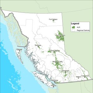
Under the ALC Act, ALR landowners must not use agricultural land for a non-farm use unless permitted by the Act or the regulations. The Act (s. 37) explicitly states that affected landowners will receive no compensation for land use restrictions, since “land is deemed not to be taken or injuriously affected by its designation as an agricultural land reserve.” Subject to certain provisions, activities designated as farm use under the ALR Use Regulation include:
- the construction, maintenance and operation of farm buildings;
- land development works;
- the storage, packing, product preparation or processing of farm products;
- the application of soil amendments, fertilisers, composts, etc.;
- farm retail sales;
- agri-tourism activities; and,
- timber production and agro-forestry.
In addition, the regulation outlines additional permitted uses that provide some flexibility for activities that are not considered to detrimentally impact future agricultural production.
The original ALR was established over a 90-day period. Each of BC’s 28 Regional Districts was made responsible for delineating reserve boundaries within their region. Boundaries were established primarily through technical analysis based on Canada Land Inventory (CLI) maps, in which agricultural potential of soils and climate are ranked into seven different categories based upon ability to produce a range of crops (Box 1, above).[30]
The BC Land Inventory (BCLI) classification index, which is adapted from the CLI, is premised upon a mechanised production system; it does not consider “distances to markets, kind of roads, location, size of farms, type of ownership, cultural patterns, skill or resources of individual operations, and hazard of crop damage by storms” in its determination.[31] In addition to the BCLI system of classification, there are also the Land Evaluation and Area Review (LEAR) system and the Land Suitability Rating System (LSRS), both of which take more factors into account. Neither of these other systems are used in BC.
From 1976 to 1996, the ALR underwent an extended period of fine-tuning, where boundaries were adjusted to account for: (1) imprecision in the original boundary setting process; (2) the inclusion of additional land inventory data; (3) local government planning priorities; and, (4) landowner appeal. Yet concerns about the validity of existing boundaries remain, while boundary reviews continue.
Despite many competing factors, since 1974, the total reserve area has remained consistent. In 50 years, total ALR lands have actually increased; however, “the quality of farmland in the ALR has decreased, with 2.8 hectares of prime farmland being excluded for every hectare of prime farmland included.”[32] This trend has manifested itself in a gradual shift of ALR lands, where 90% of farmland inclusions occur in northern regions while over 70% of exclusions take place in southern environs. The vast majority of reserve lands are now located in the Province’s northern and interior farming areas.
In May, 2014, the ALC Act was amended via Bill 24. Although the mandate of the ALC was not changed, there were several major amendments that changed how agricultural land use decisions are made. The most significant of these changes was a division of the ALR into two zones. Zone 1 comprised the Island, South Coast, and Okanagan panel regions. Zone 2 included the Interior, Kootenay, and North panel regions. As stated in the Province’s announcement of the changes,
In Zone 1, where land is in greater demand and there are development and population pressures, ALC decisions will continue to be made on the basis of the original principle of preserving agricultural land. In Zone 2, where growing seasons are shorter and there are lower value crops, ALC decisions will now, in addition to the original principle, include additional considerations to provide farmers with more flexibility to support their farming operations.[33]
In Zone 2, the ALC “must consider all of the following, in descending order of priority: (a) the purposes of the commission set out in section 6; (b) economic, cultural and social values; (c) regional and community planning objectives; (d) other prescribed considerations. Regulations to implement these changes were implemented in 2015.
The two-zone ALR was returned to a single-zone in 2019 via Bill 52, soon after a change in government. Other changes included restrictions on the size of new houses to less than 500 square metres and greater restrictions and increased penalties for dumping of construction debris, toxic waste, and other fill in the ALR. Changes were also made to regulations.
Agricultural Land Commission
As described in Section 6 of the ALC Act, the purposes of the ALC are to:
- (a) to preserve the agricultural land reserve;
(b) to encourage farming of land within the agricultural land reserve in collaboration with other communities of interest;
(c) to encourage local governments, first nations, the government and its agents to enable and accommodate farm use of land within the agricultural land reserve and uses compatible with agriculture in their plans, bylaws and policies.
2. The commission, to fulfill its purposes under subsection (1), must give priority to protecting and enhancing all of the following in exercising its powers and performing its duties under this Act:
(a) the size, integrity and continuity of the land base of the agricultural land reserve;
Resources
The ALC website is an excellent source of comprehensive information about its operations and policies, including the following:
- the ALC
- permitted uses in the ALR
- Applications and notices
- Resources
- The ALC Act and ALR regulations
- ALC policies and bulletins
- Soils and agricultural capability
Operating on the principle that the “provincial government is best able to steward the long-term food system needs of the citizens of British Columbia,”[34] the original ALC was composed of a five member panel made up of representatives from around the province. This governance structure was thought to be consistent with the Commission’s mandate to make decisions in the provincial interest. In 2002, the Commission underwent a controversial restructuring, both in mandate and board composition. In an effort to make the Commission more “regionally responsive,” the original five member panel was abandoned in favour of six regional boards (Interior, Island, Kootenay, North, Okanagan, and South Coast), each composed of three commissioners. In the same year, the ALC adopted a three-year service plan that introduced performance measure objectives “to increase the regional responsiveness of the Commission to community needs.”[35] Subsequently, the language of “community need” was incorporated into subsequent ALC service plans, with the 2009-10 plan stating, “The boundaries of the Agricultural Land Reserve reflect agricultural suitability, the needs of the agricultural industry and long term community needs and food requirements.”[36] Some critics argued that this subtle shift in the Commission’s mandate resulted in an increasing number of municipalities exercising and in some cases abusing Section 13 of the ALC Act which contains provisions for facilitated dispute resolution on community issues.[37]
Bill 15, which came into force in 2020, led to additional changes in the ALC Act. Affected areas of the ALC Act included the following: the ALC governance model (i.e., structure of the panels); more compliance and enforcement capacity and tools; new decision-making criteria to prioritize the protection and enhancement of the size, integrity, and continuity of the land base; and a requirement that applications for exclusions be submitted to the ALC only by local governments, Indigenous governments, or the Province.
In January, 2020, the Ministry of Agriculture initiated a review of its recent changes to the Act through Bill 52. The review was based on a policy direction to increase residential flexibility in the ALR. The rationale for more residential flexibility is based on several potential needs: keeping a family member (e.g., an aging parent) on the property; providing a residence for a farmer transitioning out of farming, or for a young or new person transitioning into farming; providing farmer or farm-worker accommodation, without the need to apply to the ALC; enabling a source of rental revenue.
To fulfill its mandate as set in Section 6 of the ALC Act, the ALC operates in a variety of capacities, including advising local governments on development of plans and applicable bylaws; and monitoring and auditing municipal plans and implementing bylaws for consistency with the ALC Act. However, by far the most important of the Commission’s many responsibilities is exercising decision-making authority for applications. There are several types of applications:
- Exclusion
Application to remove land from the ALR; if approved, none of the ALC Act applies to the land. The land is subject to local government bylaws.
- Inclusion
Application to designate land as ALR; if approved, the parcel is added to the ALR and the ALC Act applies to the land. The land is subject to local government bylaws.
- Subdivision
An ALR parcel is divided into two or more parcels; each parcel is legally separate. The subdivided parcels remain in the ALR unless also approved via an application for exclusion. The parcels can be any combination of sizes.
- Non-Adhering Residential Use
Permitted residential uses of ALR land are defined by the ALC Act and its regulations. For residential uses in excess of those permitted, i.e., residential uses that do not adhere to the ALC Act and its regulations, must be approved by the ALC via application.
- Non-farm uses
Literally, this refers to a use of agricultural land for non-farm purposes. Non-farm uses fall into categories of permitted and non-permitted uses. Permitted uses are defined by provincial regulations (Agricultural Land Reserve Use Regulation – 30/2019). Non-farm uses that are not permitted by regulation must be approved by the ALC via application.
-
Soil use for placement of fill or removal of soil.
A type of non-farm use. An application to remove soil from or to add material (i.e., fill) to ALR land.
- Transportation/Utility/Trail
A type of non-farm use. An application to use land for these specific non-farm uses: transportation (e.g., widening roads, new roads); utility (e.g., power lines, sewage treatment); and trails.
Since its formation in 1973 to 2012, the Commission processed over 35,000 applications, a task that consumes the majority of the ALC’s resources.[38] While the furor of applications has waned since boundary refinement, the Commission still receives anywhere from 470 to 650 applications annually. About 90% of applications are made by private landowners, with the remaining percentage comprised of local and regional governments.[39]
When the Commission reviews applications, its mandate to preserve the agricultural land reserve serves as the primary criteria for making decisions.[40] Considerations for agricultural capability of the parcel, agricultural suitability, and impact on agriculture help to inform the Commission’s decisions.
Agricultural capability
Considers whether the property is appropriately designated as ALR.
The effects of a change in agricultural land use would consider the agricultural capability of the soil. The BCLI ratings are the basis for evaluating capability and would be completed usually by a professional agrologist. Related objectives are to mitigate impacts on prime agricultural areas and directing non-farm uses to agricultural land of lower capability.
Agricultural suitability
Considers whether the proposed land use change would affect the agricultural utility (or capability) of the property.
The first step is to consider agricultural capability through the lens of suitability for agricultural use, including variation of agricultural capability within the parcel as well as inhibiting sub-classes (e.g., excess water, stoniness, topography). Suitability also considers the current state of the subject property regarding such factors as property size, shape, and limitations to agriculture, such as linear disturbances (roads, transmission lines, water bodies). Suitability also considers external pressures from surrounding land uses on the subject parcel, including whether factors such as encroaching non-farm development have caused or will cause the land to be unsuitable for agriculture.
Impact on agriculture
Considers whether there is an agricultural benefit to the subject parcel and local area.
The Commission will consider whether the proposed land use change would negatively or positively affect existing or potential use of agricultural land in the surrounding area. For example, the Commission is reluctant to allow exclusions where there are existing agricultural land holdings and active farming or ranching is occurring.
Inevitably, land owners applying to the ALC for an exclusion or non-farm use and the ALC do not always agree on either the outcome or the criteria. Regarding the criteria, the ALC is concerned with “what is” while applicants often base their argument on “what should be.”[41] For instance, the ALC will assess the capability of the parcel for agriculture whereas the applicant might focus on the viability of the farming operation. From the ALC’s perspective, viability is predicated on the operator’s skills and abilities, not on the capability of the soil. It is not within the mandate of the ALC to assess or consider the viability of the operator.
Ministry of Agriculture
The portfolio of the Ministry includes responsibilities pertaining to:
- achieving a balance between agricultural and urban interests;
- promoting environmental, social, and human health by regulating food production practices;
- monitoring and managing risk of disease (agricultural, horticultural, and aquacultural);
- guiding economic development of the agricultural sector to “increase innovation, competitiveness and profitability”;
- providing farmer income stabilisation programs; and,
- developing agricultural legislation as well as strategic and operational policy.42
The Ministry is responsible for administering the provincial Strengthening Farming Program, which “supports fair resolution of land use conflicts and effective community planning for a sustainable agriculture and aquaculture industry in British Columbia.” A tenet of this program is providing legislative support for farming activities through the Farm Practices Protection (Right to Farm) Act (RSBC 1996 Ch 131) also known as the “Right to Farm” Act. The legislation affirms that BC farmers will not be held liable for nuisances caused by agricultural activities. The organisation formed to resolve disputes under the act is the quasi-judicial Farm Industry Review Board, which determines whether or not a farmer has followed normal farm practices. The Strengthening Farming Program also provides the planning framework for integrating farming for municipal, regional, and provincial government bodies. Currently, there are three types of plans that directly or indirectly speak to agricultural land use priorities: (1) Regional Growth Strategies; (2) Official Community Plans; and, (3) Agricultural Area Plans.
Regional Growth Strategies
BC’s unincorporated areas contain the majority (~ 95%) of ALR lands within the province. As a result, regional districts can play a significant role in co-ordinating compatible uses around existing and future farmlands. “Regional planning can also strategically address deficiencies in the links between local governments and provincial ministries and agencies, and can set in place broad regional land use objectives.”[42]
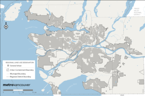
Under Part 13 of the Local Government Act (RSBC 2015 Ch 1), a regional district may enter into an agreement with its member municipalities to enact a Regional Growth Strategy (RGS) with the “purpose of guiding decisions on growth, change and development within its regional district.” This is accomplished by planning across municipal boundaries to achieve a shared vision for a district by articulating specific goals related to social, economic, and environmental values. Once enacted, all subsequent bylaws and land use plans must be consistent with the RGS. A RGS may also benefit agricultural lands by protecting farmlands through the creation of urban containment boundaries (for an example see Map 2) and developing planning strategies to support and enhance a region’s agricultural sector. For example, the Metro Vancouver Regional Growth Strategy states a clear commitment to farmland protection as part of a comprehensive approach to planning for a regional food system. Strategy 2.3 of the RGS states, for example, “Protect the supply of agricultural land and promote agricultural viability with an emphasis on food production.” This strong statement is supported by clear commitments to urban containment boundaries. In addition, Metro Vancouver completed a regional agricultural land use inventory, a regional food system strategy, and action plan.
Map 2. Example of Urban Containment Boundary
Official Community Plans (OCPs)
The relevance of an Official Community Plans (OCPs) to BC’s agricultural land base depends on the total area of ALR land included within a municipal boundary. Part 14 Section 473(1)(b) of the Local Government Act requires a municipality to include statements (objectives) and map designations respecting “the approximate location, amount and type of present and proposed” agricultural land uses. Farming land use designations should include all ALR lands, and may include non-ALR lands. In addition, section 474(1)(c) permits an OCP to include “policies… respecting the maintenance and enhancement of farming on land in a farming area or in an area designated for agricultural use in the plan.” Further, local governments (regional districts and municipalities) can take a more active role in agricultural planning through a variety of methods, as evident by the efforts of Metro Vancouver noted above.
OCPs may include reference to preserving contiguous agricultural areas, allowing for a wide range of farming land uses, restrictions on road construction, etc. The District of Central Saanich OCP (2023) provides an example of strong agricultural policy:
Objective: Preserve lands with potential for agricultural production. Protect these areas from incompatible and detrimental land uses, and support efforts to increase the productivity of farmlands to improve food security to support a healthy community.
Policy 1: Retain areas designated as Agriculture on Schedule F: Land Use Plan for agricultural purposes regardless of any changes that may be made by the Provincial government with respect to the Agricultural Land Reserve.
An OCP may also establish Development Permit Areas to minimise land use conflict in the agriculture-urban interface. The farming-sensitive permit areas may provide detailed development requirements including (but not limited to):
- setbacks, fencing, and landscape buffers;
- awareness covenants;
- stormwater management;
- appropriate zoning designations for lands adjacent to agricultural areas; and,
- restrictions on infrastructure that may encourage non-farm speculation in the future.
Zoning bylaws are the primary mechanism through which OCP land use designations are implemented. Zoning bylaws allow a local government to enforce specific regulations related to permitted uses, minimum lot sizes, lot coverage, etc. Under Part 14 Division 17 of the Local Government Act, a municipality may also choose to enact farm bylaws, which “allow for greater flexibility in standards for farming…matters which cannot be regulated by zoning bylaws.”[43] Farm bylaws are local standards regulating conduct of farm operations, farm buildings, and farming materials/waste handling. However, the real merit of farming bylaws is the ability to develop different regulations depending on the size, type, and location of a farming operation.
An OCP may also identify and provide policy direction for “edge planning” areas along the agricultural-urban interface. For example, an OCP may require modified building standards for an edge planning area, such as double-paned windows for residences in order to reduce noise and odour nuisances. Roadway ordinances may suggest that no roadway endings can be pointed towards an agricultural area. Many municipalities also incorporate signage requirements in agricultural areas to increase resident awareness. However, perhaps the most widely used technique in edge planning is buffering, which incorporates a combination of separation of uses, dense vegetation, and fencing. While buffers may vary widely in type, including earth mounding, ditches, retention ponds, etc., the Ministry’s Guide to Edge Planning recommends these specifications for buffers:
- A total minimum separation distance of 30 m (15 m of which is a vegetative buffer) between a housing unit and agriculture-urban boundary;
- A barrier (fence) to deter trespass;
- A vegetative buffer with a finished height of at least 6 metres to act as a screen and help capture dust and spray drift;
- A mixed deciduous and coniferous planting; densely packed hedges are not desirable due to poor air circulation;
- A 2-metre separation distance between a low-growing vegetative buffer and agriculture-urban boundary; and,
- Any pathway or passive recreation along the buffer should be set far away from the farms.[44]
Agricultural Area Plans
An Agricultural Area Plan (AAP) is a planning tool that municipalities may use to identify issues, opportunities, and solutions related to the farming sector’s future. Essentially, AAPs “act as sub-area or neighbourhood plans of the OCP and provide a high level of detail specific to the issues relevant to farming.”[45] AAPs are part of a logical planning hierarchy with the additional benefit of allowing for cross-jurisdictional management of agricultural lands.
Ideally, AAPs are prepared as a collaborative effort between a municipal government, the provincial government, the ALC, and most importantly, the farming sector. Members from these groups are usually organised as an AAP Working Group or Agricultural Advisory Committee. While each AAP is necessarily unique, the plans will likely include:
- a map delineating the agricultural area;
- a comprehensive inventory of current agricultural production and future projections;
- strategies and policies designed to protect agricultural areas;
- strategies and polices designed to enhance the economic viability of the local agricultural sector;
- a detailed implementation plan, complete with responsible actors, timelines, and budget allocations; and,
- monitoring regimes to assess the progress of plan implementation.
Agricultural Impact Assessment
Another important tool available to planners and agrologists is an agricultural impact assessment (AIA). Ideally, an AIA is required when considering non-farm developments that affect agricultural land and farming or ranching activities. Relevant considerations include capability of the soil, suitability of the land for agricultural uses, negative impacts on the industry, fragmentation of the land base, minimum parcel sizes, direct development away from prime and viable agricultural lands, and mitigate negative impacts on existing or adjacent agricultural areas. Agricultural impact assessments are usually completed by a professional agrologist. The Land Evaluation and Area Review (LEAR) system and the Land Suitability Rating System (LSRS), both of which take multiple factors into account, can be incorporated into an AIA.
Media Attributions
- Map 1. ALR in British Columbia © Agricultural Land Commission is licensed under a All Rights Reserved license
- Map 3. Example of Urban Containment Boundary © Metro Vancouver Regional District is licensed under a Public Domain license
- Smith, Barry E. (1998). Planning for Agriculture. Burnaby, BC: Provincial Agricultural Land Commission. ↵
- Wilson, B. K. and P. Finkle (1990). “Is Agriculture Different? Another Round in the Battle Between Theory and Practice,” p. 15. In G. Skogstad and A. F. Cooper (Eds.), Agricultural Trade: Domestic Pressures and International Tensions. Halifax, NS: The Institute for Research on Public Policy, pp. 39-60. ↵
- Fowke, V. C. (1978 [1946]). Canadian Agricultural Policy: The Historical Pattern. Toronto, ON: University of Toronto Press. ↵
- Troughton, M. (2007). “Canadian Farmland: A Fluctuating Commodity.” In W. Caldwell, S. Hilts, and B. Wilton (Eds.), Farmland Preservation: Land for Future Generations. Guelph, ON: University of Guelph. ↵
- Skogstad, G. (2012). “Affecting Paradigm Change in the Canadian Agriculture and Food Sector.” In R. MacRae and E. Abergal (Eds.), Health and Sustainability in the Canadian Food System. Vancouver, BC: UBC Press, pp. 17-38. ↵
- Skogstad (2012). ↵
- Advisory Council on Economic Growth (2017). Unleashing the Growth Potential of Economic Sectors. Government of Canada, Ottawa, ON. ↵
- Hofmann, N., G. Filoso, and M. Schofield (2005). Rural and Small Town Canada Analysis Bulletin Vol. 6, No. 1. Ottawa: Statistics Canada, Catalogue no. 21-006-XIE. Statistics Canada (2014). Human Activity and the Environment: Agriculture in Canada. Environment, Energy and Transportation Statistics Division. Catalogue no. 16-201-X. ↵
- Connell, David J., Chris Bryant, Wayne Caldwell, Greg Cameron, and Tom Johnston (2019). “Protecting Farmland in Canada: Provincial Legislative Frameworks.” In Heather McLeod-Kilmurray, Angela Lee & Nathalie Chalifour, eds, Food Law and Policy in Canada. Toronto, ON: Carswell. ↵
- Hofmann, Filoso, & Schofield (2005). ↵
- Hiley, J. (2007). “Opening Gates, Not Reinforcing Fences: Land Use Planning in Canada,” p. 163. In W. Caldwell, S. Hilts, and B. Wilton (Eds.), Farmland Preservation: Land for Future Generations. Guelph, ON: University of Guelph. ↵
- Standing Committee on Agriculture and Agri-Food (2010). Competitiveness of Canadian Agriculture. Report of the Standing Committee on Agriculture and Agri-Food. Ottawa, ON: Government of Canada. ↵
- Food Secure Canada. What is Food Sovereignty? ↵
- Agricultural Land Commission (2013). Agricultural Capability and the ALR. Fact Sheet. Burnaby, BC: Agricultural Land Commission. ↵
- Land Conservancy of British Columbia and FarmFolk CityFolk (2009). BC’s farming and food future: local government toolkit for sustainable food production. Victoria: The Land Conservancy of British Columbia. ↵
- Ministry of Agriculture (2022; updated March, 2022). Fast Stats 2020: British Columbia’s Agriculture. Food, and Seafood Sector. Victoria, BC. ↵
- First Call Child and Youth Advocacy Society (2023). 2022 BC Child Poverty Report Card. Vancouver, BC: First Call Child and Youth Advocacy Society. ↵
- For more information, visit the Investment Agriculture Foundation webpage on climate change. ↵
- Ministry of Agriculture (2015). Guide to Edge Planning: Promoting Compatibility along Urban-Agricultural Edges. Abbotsford, BC: Ministry of Agriculture. ↵
- Ministry of Agriculture (2015) ↵
- Statistics Canada (2006). "British Columbia's farm population: changes over a lifetime." Ministry of Agriculture and Food (2022). British Columbia Agriculture in Brief 2021. Victoria, BC: Sector Insights and Corporate Initiatives Unit. ↵
- Statistics Canada (2023). Census of Agriculture: Community Profiles. ↵
- Ministry of Agriculture (2016). Fast Stats 2015. ↵
- Statistics Canada (2023). ↵
- Crawford, E., and R. Beveridge (2013). Strengthening BC’s Agriculture Sector in the Face of Climate Change. Victoria, BC: Pacific Institute for Climate Solutions, p. 9. ↵
- Crawford and Beveridge (2013), p. 10. ↵
- The name of the Ministry has changed over time, but has always retained the word “agriculture.” In this case, we refer to the Ministry of Agriculture as a general name, forgoing the specific name at various times. ↵
- Campbell, C. (2006). Forever farmland: Reshaping the Agricultural Land Reserve for the 21st century. David Suzuki Foundation, p. 8. ↵
- Agricultural Land Commission. The ALC Act and ALR Regulations. ↵
- For more details, refer to: Kenk, E. and I. Cotic (1983). Land Capability Classification for Agriculture in British Columbia. MOE Manual 1. Kelowna, BC: BC Ministry of Agriculture and Food and BC Ministry of Environment. ↵
- Agriculture and Agri-Food Canada. "Overview of classification methodology for determining land capability for agriculture." ↵
- Curran, D. (2007). British Columbia’s Agricultural Land Reserve: A legal review of the question of “community need”. Vancouver: SmartGrowth BC, p. 5. ↵
- Province of BC 2014. “Improvements to ALC protect farmland, support farmers.” [media release]. Victoria, BC: Government of British Columbia. ↵
- Curran (2007), p. i. ↵
- Land Reserve Commission "Service Plan 2002/2003 – 2004/2005", p. 4. ↵
- Land Reserve Commission "Service Plan 2007/2008 – 2009/2010”, p. 13. ↵
- See Curran (2007). ↵
- Past applications to the ALC and the ALC decisions are available on-line. ↵
- Smith, B. (2012). A Work in Progress: The British Columbia Farmland Preservation Program. Agricultural Land Commission. ↵
- For a full discussion, see the ALC's What the Commission Considers. ↵
- Pierce, J. T., and J. Séguin. 1993. “Exclusive Agricultural Zoning in British Columbia and Québec: Problems and Prospects.” In A. W. Gilg (Ed.), Progress in Rural Policy and Planning, Vol. 3, pp. 287-310. London: Bellhaven Press. ↵
- BC Ministry of Agriculture and Lands. " Service Plan 2010/11 – 2012/13”, p. 6. ↵
- Ministry of Agriculture and Lands (1998). Guide for Bylaw Development in Farming Areas, p. C-7. ↵
- Ministry of Agriculture (2015), pp. 19-20. ↵
- Curran, D. (2005). Protecting the working landscape of agriculture: A smart growth direction for municipalities in British Columbia. West Coast Environmental Law Research Foundation, p. 21. ↵

Feedback/Errata