Case. Prince George: Planning for Low Growth
URBAN PLANNING CASE STUDY
Learning Objectives
The historical of development Prince George, British Columbia, provides the context for understanding many challenges of urban planning over the past 100 years. The City’s history begins with early townsites and the dispossession of Indigenous lands of the Lheidli T’enneh and leads to periods of uncontrolled growth and, later, an extended period of no growth. Learners should consider the roles and contributions of the professional land use planner throughout the history of the city’s development, including the legislative and regulatory tools employed to both support and discourage development. Learners are encouraged to analyse the elements of public, private, and government interests, the function of various land use plans, and the implementation tools that have helped shape BC’s ‘northern capital’ over the past one hundred years and how will shape it for the foreseeable future.
Attribution
Upon arrival in Prince George, British Columbia, a visitor is likely to first notice its industrial developments. The pulp mills, rail yards, and supporting industries are some of the most prominent features of the City, which make Prince George typical of many cities and towns in rural British Columbia. Visitors will also notice the requisite ‘big box’ store developments, casino, golf courses, and chain restaurants, which make the City typical of most cities in North America. What visitors may not notice immediately, but will come to appreciate if they stay long enough, is a healthy network of social, arts, and cultural activities. Yet, what is least obvious is how the City arrived at its present state. While the proximity to the Nechako and Fraser rivers suggests why the City is located where it is, the current pattern of development seems to defy many principles of good urban design.
Key facts
Unceded traditional territory of the Lheidli T’enneh
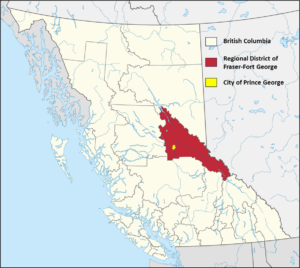
The City of Prince George is located on the unceded traditional territory of the Lheidli T’enneh and ancestral lands of the Dakelh (Map 2). The Dakelh are believed to be central BC’s first residents and are ancestors to the Lheidli T’enneh. The name of the latter can be translated as follows: Lheidli means “where the two rivers flow together” and T’enneh means “the People.”[1]
Map 1. Prince George located in the Regional District of Fraser-Fort George
In the early twentieth century, the few permanent residents of European ancestry were employees of the Hudson Bay Company. During this time, the modest settlement of Fort George served as an important fur trading post. This settlement would be permanently changed when it was discovered that the Grand Trunk Pacific Railway would be travelling through Fort George, an announcement that set off a flurry of land speculation and development in the area. From here forward for Prince George, like other settlements of the North American West, “[n]othing could be further from the truth than the notion that Western towns originated as spontaneous crossroad hamlets that grew slowly, incrementally, and randomly, without guidance of direction.” To the contrary, Prince George is the result of numerous efforts to guide and restrict growth.
Notwithstanding numerous planning initiatives to fulfill its destiny as B.C.’s “northern capital,” Prince George has not achieved most of its predicted growth scenarios. This shortcoming has presented significant difficulties to direct growth and development throughout its history.
Map 2. Traditional territory of the Lheidli T’enneh (unceded)

First Townsites
The first townsite plans (Figure 1) at the confluence of the Nechako and Fraser rivers were registered in 1909/10 by a group of investors known as the Northern Development Company. The new townsite was called South Fort George. Nearby, a competing townsite called Central Fort George was being built by another investment group, the Natural Resources Security Company, who promoted Central Fort George as having huge development potential. The townsites of South and Central Fort George were home to roughly 1,500 residents and thousands of temporary construction workers who worked in the region.[2]
Figure 1. Map of early townsites and Fort George Indian Reserve in 1910
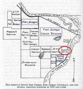
All the while, the influential Grand Trunk Pacific Railway was moving ahead with its plans for another townsite. Grand Trunk solicited the federal government for purchase of the Fort George Indian Reserve lands. After extended rounds of negotiations, and highly questionable tactics, the dispossession of the Reserve lands to the Grand Trunk Pacific Railway was completed in 1912.[3] Building at this third townsite commenced the following year. Following the announcement that the train station would be located within Grand Trunk lands, the newest townsite was incorporated in 1915 as the Town of Prince George. Figure 2 shows an early image of the new town.
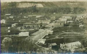
Figure 2. Early image of George Street, City of Prince George (c1915)
Early Development
When the first train arrived in 1914 there was already sufficient investment in the regional forestry industry to ensure prosperity for the area. At the peak of speculation, the greater Fort George area boasted fourteen completed subdivision plans, equalling roughly 22,800 lots in the three separate townsites.
For the two original townsites, over two-thirds of the subdivided lots had gone undeveloped, and much of this vacant land was abandoned by its owners and reverted back to the provincial government. Although South Fort George managed to maintain a small population, Central Fort George was eventually completely deserted. Meanwhile, the Town of Prince George had quickly established itself as the industrial and administrative capital of Northern BC.
The War Years
During the war years from 1941-45, Prince George’s population expanded from roughly 2,000 to 3,800 people; an annual increase of 18%.[4] Many of the new migrants were attracted by the expanding forest industry and the increased provision of services. However, due to wartime lumber restrictions, much of the new development was poorly constructed and without basic sanitary infrastructure. Adding to these woes in 1942, Prince George “was to be invaded and literally taken over by one of the largest army camps in Canada,” with roughly 10,000 soldiers temporarily taking residence in the bustling town.[5]
Gaining Control of Development
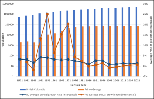
The post-war era was the start of a long period of sustained population growth for Prince George. As illustrated in Chart 1, from 1921 to 2021, average annual growth in the City of Prince George outpaced that of a prospering British Columbia at times, although the pace of growth fluctuated wildly. As noted below, several of the population increases were due to expansion of municipal boundaries, thus encompassing the population of rural areas. As the City expanded both demographically and economically, so too did the challenges of managing growth, with low-density, haphazard development spreading beyond the Town of Prince George into South Fort George, the former Central Fort George, and surrounding areas.
To accommodate the influx of new residents who were arriving at an accelerating pace in the 1950s and to deal with the increasingly dilapidated and disorganised cityscape, the City recognised that some form of land use planning was required. Subsequently, this need was addressed in several capacities, including the following:
- creation of the first zoning bylaws;
- formation of a Town Planning Commission;
- westward expansion of municipal boundaries in 1953-56; and,
- southern expansion of municipal boundaries in 1958.
Chart 1. Population Growth and Average Annual Growth (%) in Prince George and British Columbia: 1921-2021
As well, in 1957, in order to gain more control over development, Prince George acquired the land rights to all undeveloped parcels within city limits from the Province, who still owned large tracts of land following the initial subdivision boom. The effectiveness of this bold strategy is well illustrated by Desmond Parker, the City’s de facto planner from 1957-75, who reflects:
By implementing a wise policy of containment, made possible by the public ownership of land, the City has forced development into the previous lower density areas and achieved a saturation of existing services. The shortage of land and the definite policy of inhibiting premature subdivision, coupled with the rapid growth of the community, have brought about a natural renewal.[6]
This “natural renewal” was a form of control over development. Having gained an upper hand, the City approved three new subdivisions between 1958 and 1965: Seymour, Spruceland, and Highland. These subdivisions were developed as urban infill and also eschewed the monotony of gridiron subdivision for the aesthetics of neighbourhood design.
Each new subdivision was planned to function as a self-contained neighbourhood complete with commercial and educational services within reasonable distance of all housing units. The neighbourhood concept was such a success that, thereafter, the City required all private developers to incorporate neighbourhood-level planning into subdivision proposals. The influence of this planning policy is evident by the College Heights neighbourhood established in the mid-1970s.
Great Expectations
In the late 1960s, due in part to the establishment of three new pulp mills, Prince George (pop. 25,853) was Canada’s fastest growing city with an annual average population growth of 15.3%.[7] During this period the city completed some progressive land use planning including additional boundary expansions, the creation of a new zoning bylaw (1967), and an Official Community Plan (OCP) (1969). However, the growth that was taking place outside city limits along the Hart Highway and North Nechako Road severely compromised on-going efforts to develop a comprehensive plan. In 1969, the population of these so-called “rural slums” was estimated to be around 10,000.[8]
The Regional District of Fraser-Fort George (RDFFG) was established in 1969, consisting of eight Electoral Areas (from A to H), as shown in Map 4. The Regional District adopted its first Official Regional Plan in 1972; each Electoral Area has an OCP. These steps helped to improve rural building and development standards. At this time, the greater Prince George area was projected to have a population range anywhere from 325,000 to 470,000 by the year 2000.[9] To accommodate these projections, the Region’s Official Regional Plan supported the development of three ‘satellite towns’ directly abutting the ‘urban core’ of Prince George, thus supporting rampant subdivision development in the surrounding areas. By 1974 the estimated population outside City limits had increased to roughly 25,000.[10]
The Regional District’s plan for a “Greater Prince George,” ambitious even in its day, was abandoned in 1974 after the City’s newly created Planning Department proposed a very aggressive boundary extension.[11] The expansion would incorporate large areas beyond the “bowl” to include South Fort George, Peden Hill, Cranbrook Hill, College Heights, Beaverly, Blackburn, North Nechako, and the Hart.[12] The effect was to bring the adjacent rural populations within City limits, and more than double the City’s population to over 60,000 people. This form of multi-municipality restructuring took place within a provincial initiative that also guided restructuring in Kamloops, Kelowna, and Nanaimo. In Prince George, although the restructuring was mandated by the province, local politicians supported the action.[13]
While this strategy was initiated by the Province of British Columbia[14] and supported by the City of Prince George and the majority of city residents, it was vehemently opposed by rural landowners and developers who (correctly) feared increased taxation rates and development regulation. This divided support was reflected in a referendum, which saw the plans for restructuring narrowly pass by 55.3% in the vote held on November 2, 1974.[15] Save a few minor adjustments, the form of present day City of Prince George and Regional District of Fraser-Fort George had been established.
Coming to Terms
What followed was a series of public hearings that served to intensify the conflict between the City and some members of the development industry. Critics of the plan focused upon the liberal allocation of greenspace within the Hart area and the phased development designations that would greatly restrict rural expansion until a future date. Despite significant efforts to incorporate public input, the City was nonetheless accused of “trying to stifle free-enterprise by forcing a community plan down residents’ throats.”[16] As reported in the same newspaper article, the prevailing attitude of the opposition is perhaps best illustrated by the sentiment of a local land dealer who declared in a public hearing, “We should be planning for today…not for tomorrow.”
Perspective: Dan Milburn (RPP MCIP), Former Manager of Long Range Planning, City of Prince George
Notwithstanding challenges, the OCP and zoning bylaw passed Council relatively unscathed in 1979, largely abetted by the continued growth that allowed the City to push back against poorly planned development. However, these achievements were not without casualty. In 1978, the City’s first Planning Director resigned after being lambasted with “allegations of incompetence, lying, personal vendettas, and bias.”[17] The City’s new growth management policy was complemented by RDFFG’s updated Official Regional Plan, also approved in 1979, that prioritised industrial and commercial development in the rural fringes, and offered comparatively modest allocations for rural residential lifestyles.
By 1980, the City had gained control of growth in greater Prince George. Unfortunately, the previous 40 years of growth outside of the city limits, with insufficient planning and development controls, had resulted in a very dispersed urban form outside of the bowl area.…[The] City was now responsible for providing and improving the services and amenities to these areas, and in dealing with the numerous functional problems associated with poorly coordinated and organized development.[18]
In 1981, Prince George had a population of 67,559, which made it the second largest city in BC behind Vancouver and ahead of Victoria (population 64,379). This height of development marked the end of the City’s era of unprecedented growth. What followed represented a new chapter in the life of the City full of completely different challenges.
Sprawl and Stagnation
The new City plans were clearly focussed on managing growth, with a projected population of 98,500 by 1991. As stated in the OCP, “[T]o accommodate the projected growth, very large areas were designated for residential development and extensive tracts were shown for industrial use.”[19] Subdivision developments in the newly incorporated areas continued with an all-but exclusive emphasis on single-family dwellings, which is a source of the ‘urban sprawl’ that we see in Prince George today. However, while the City was sprawling, its economy was shrinking. “It is somewhat ironic that once the City of Prince George became able to properly plan for its future growth, the province would be subject to an economic recession that would last over ten years, resulting in little or no growth” in the city.[20]
Perspective: Milburn (RPP MCIP), Former Manager of Long Range Planning, City of Prince George
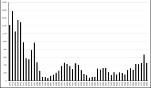
The economic recession left an indelible impact on the development of Prince George. After strong years of housing starts in 1982 and 1983, the market collapsed (Chart 2). During the height of the recession, housing starts suffered a decline of over 600% while average population growth stagnated at 0.1% annually (Chart 1). Vacancy rates reached a high of 15%.[21] The low growth rate of the population has remained flat to this day.
Chart 2. Housing Starts in Prince George: 1982-2009
Perspective: Kerry Pateman (RPP MCIP), Former planner, City of Prince George
In the early 1990s, the construction of a new courthouse, civic centre, and the University of Northern British Columbia (UNBC) breathed new life into the City, as many heralded the dawn of a new era for Prince George. There were modest gains in population and housing starts, although not close to the fever pitch of the ‘boom era’. Meanwhile, the outdated population projections of the 1979 OCP were discarded in favour of a new plan in 1993. The 1993 OCP was considered a significant change in the City’s approach to growth management and guided by the following projections and principles:
- a moderate growth rate (1 to 1.5%) based upon shortened projection timeframes (15 years);
- the introduction of a “potential future development” designation (F) to replace the extravagant industrial allocations contained in the 1979 OCP;
- a recognition of Prince George’s increasing reliance on a service-based economy;
- a five-year phased development designed to increase infill development, specifically focused upon multi-family residential.[22]
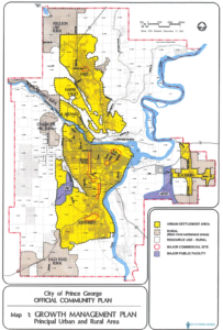
In addition, the 1993 OCP espoused tenets of winter city infrastructure and aesthetics, healthy communities, and sustainability. These ideals were promoted even further in the 2001 OCP, whose vision statement expanded upon ideals of environmental stewardship, social responsibility, economic diversity, and public participation. Perhaps more tangibly, the 2001 OCP formally recognised growth management as a planning priority, dedicating an entire chapter to principles and policies intended to achieve a vision of “concentrated growth.” One such policy involved the creation of a long-term Urban Development Boundary, shown in Map 3, that spatially delineated the maximum allowable extent for future development. Unfortunately, hindsight has suggested that the seemingly progressive policies contained within in the 2001 OCP have “not prevented any development that wanted to happen.”[23]
Map 3. Urban Development Boundary for City of Prince George, BC
Perspective: Kerry Pateman (RPP MCIP), Former planner, City of Prince George
Perspective: Dan Milburn (RPP MCIP), Former Manager of Long Range Planning, City of Prince George
The developers don’t care where they make their money – if it comes out of the left hand pocket or the right hand pocket. If we can create a way to focus growth, but still point them to development opportunities where they’ll make money – hopefully even more money – that’s good, right? You can’t have a plan that’s not economically sustainable.…The more challenging issue is how you transition from pretty much allowing anything, to a more focused, infill-type development while acknowledging there are some embedded investment interests in these lands. In some cases, it’s just the planning; but in others, the developers have contributed to actual capital works. To simply cut people off sends a very problematic signal to the investment community, runs counter to all our planning for the last nine years, and potentially, is also an unjust enrichment – where the City has been unjustly enriched by their capital infrastructure investments. So there’s a few legitimate arguments they’re bringing to bear.
The Prince George of the early twenty-first century is focussed on economic development and downtown revitalisation. Economic development has been moving forward in the face of the long-term effects of the Mountain Pine Beetle epidemic, the crisis of the global financial system, the collapse of the U.S. housing market, and COVID. Tapping into the global transportation system is the catalyst for airport expansion and its related developments, including construction of the boundary road and industrial development.
Perspective: Dan Milburn (RPP MCIP), Former Manager of Long Range Planning, City of Prince George
From a city’s perspective, the goal isn’t necessarily to have rampant growth just to increase the tax base, although some might say that. At the end of the day, there’s a lot of cost that comes with that growth. So, are we net gaining or losing by doing new development?
Perspective: Kerry Pateman (RPP MCIP), Former planner, City of Prince George
There’s always the belief that you’re going to continue to grow. And, as soon as the City enters into a discussion about developing private land, there’s a belief by the developer that the City has accepted that the land will be developed. There’s so much perceived political commitment to landowners, that they have some sort of right, that it’s going to take a really strong city counsellor, or planner, to turn that around and say, ‘Sorry, you will not get to develop.’ we haven’t grown in population, it doesn’t matter how many community plans we bring in that say ‘We’ve got a 1.5%, 3%, 0.25% growth rate.’ Unless you’re willing to make some strict statements, you’re not going to get a new form of community.
The City Today
In 2010, the City of Prince George completed a thirty-year integrated sustainability plan called “myPG.” The long-term planning exercise aimed to address several key challenges:
- Air quality issues
- Social issues
- A downtown in need of revitalization
- A dispersed and costly development pattern
- Modest population growth and an aging
- population
- Dependence on global markets and
- resource prices
- Risk of flooding
In the face of these at-home challenges, the planning team formulated four “plausible” scenarios based on external forces. These scenarios guided the planning process.
- Weathering the storm
Significant climate change leads to mass migration, disease, and other stresses. However, there is a global effort to adapt to climate change, and North Americans make changes to their standard of living to minimize negative impacts elsewhere.
- An easy ride
With few impacts of climate change, developing countries grow and compete for resources. Local cooperation leads to more self-sufficient local economies, with more compact cities, healthier lifestyles, and strong local food systems.
- Overwhelmed by global shifts
Developing countries get stronger, and North America loses its prominence, with local regions adopting a fortress mentality and fighting one another for ever more scarce and expensive food, fuel, and other resources.
- Rising costs, rising conflict
With few climate impacts, growth of developing countries and an aging population lead to higher energy and health costs, putting pressure on government and household finances. The poor and lower middle class are hardest-hit, and disparity and related conflict rise.
The planning team then developed four myPG growth management strategies to illustrate how both internal and external factors inform land use.
- Base Case: Existing OCP
- Disperse Growth Within the Serviced Area
- Focus Growth in Centres and Along Major Streets
- Focus Growth Near Downtown and Major Centres
Deliberations of the myPG planning process led to the following vision:
As BC’s northern capital, Prince George is a model for sustainable Canadian cities. The local environment is healthy, supporting a robust economy and an enviable quality of life for residents. Everyone has housing they can afford, good food on the table, and a strong, supportive network of friends and co-workers. Built on regional assets, the economy is strong and stable. A vibrant downtown, great community, affordable lifestyle, and spectacular natural setting are Prince George’s greatest strengths.[24]
This vision informed the development of the City’s Official Community Plan (OCP), which was adopted in 2012. The OCP embraced a vision of the City as a strong, stable economy, a vibrant downtown, great neighbourhoods, affordable lifestyle, and spectacular natural setting. The annual population growth rate was expected to range from 0.4% to 1.2% through to 2025. Principles of Smart Growth and new urbanism were incorporated.
For much of the period between 2010 and 2020, the general impression of downtown Prince George was one of revival. Many new stores and restaurants opened with accolades to the city for its commitment to supporting downtown development. As well, in 2015, the City celebrated its 100th anniversary and hosted the Canada Winter Games. The Games contributed significantly to the local economy and left many legacy projects, such as upgrades to arenas and outdoor ice oval.
Amidst the positive developments, much went on behind the scenes by the City to ensure that projects were supported, approved, and implemented. The City asked residents twice to approve long-term debt financing. In October, 2017, residents approved proposals for the City to borrow a $50 million for a new pool ($39 million) and new Fire Hall No. 1 ($15 million). In May, 2019, residents were asked to approve a proposal for the City to borrow $32 million to pay for 11 infrastructure projects (most of these projects were not downtown). And much more about the costs were revealed in local newspapers. Projects that took place downtown are described in the following Learning Module.
Although never short of ideas for future development, the City of Prince George of today remains bound to its reality of low growth. As well, in spite of the list of achievements, the City, like many other cities across Canada, has struggled with homelessness and related issues in its downtown area over the past few years.
Learning modules that support this case study
This module describes a range of planning tools available to local governments to help control and direct urban development. These tools are regulated under provincial legislation.
-
Downtown Property Developments in the City of Prince George
This module describes development projects that have been completed in the City’s downtown area since 2011. Collectively, these property developments help learners understand the current state of downtown Prince George.
Media Attributions
- Map 1. Prince George located in the Regional District of Fraser-Fort George © Awmcphee is licensed under a Public Domain license
- Map 2. Traditional territory of the Lheidli T’enneh (approximate boundary)
- Figure 1. Map of early townsites and Fort George Indian Reserve in 1910 © Rev. F. E. Runnalls adapted by Caroline Ross is licensed under a CC BY (Attribution) license
- Figure 2. Early image of George Street, City of Prince George (c1915) © Northern BC Archives & Special Collections is licensed under a Public Domain license
- Chart 1. Population Growth and Average Annual Growth (%) in Prince George and British Columbia: 1921-2021
- Chart 2. Housing Starts in Prince George: 1972-2022 © Statistics Canada
- Map 3. Urban settlement boundary, Official Community Plan 2001. © City of Prince George
- “Lheidli T’enneh” (n.d.). ↵
- West, W J. (1985). Stagecoach and sternwheel days in the Cariboo and Central B.C.. Surrey: Heritage House Publishing Company Ltd., p. 34. ↵
- Vogt, D., and D. A. Alexander (2010). “‘You Don’t Suppose The Dominion Government Wants to Cheat the Indians?’: The Grand Trunk Pacific Railway and the Fort George Reserve, 1908-1912.” BC Studies 166 (Summer): 55-72. ↵
- Llewellyn (1999), p. 51. ↵
- Sugden, Jessie B. In the Shadow of the Cutbanks. 2nd ed. Prince George, British Columbia: Fraser-Fort George Museum Society, 1986: 28. ↵
- Parker, Desmond. PG urban renewal study. Prince George, British Columbia: Central Interior Planning Consultants, 1965: IIX-2, as quoted by Llewellyn (1999), 51. ↵
- Llewellyn (1999), p. 53. ↵
- Llewellyn (1999), p. 79. ↵
- Suri, Chander. Proposed master plan Greater Prince George - Phase 1. Prince George, British Columbia: Regional District of Fraser-Fort George, n.d.:62-63. Note: the population of the City in 2016 was 74,003, and about 87,000 when including the surrounding area. ↵
- Llewellyn (1999), p. 96. ↵
- For more details, refer to a multi-part account of the restructuring published in the Prince George Citizen newspaper. ↵
- Since the original townsite plan of 1915, the “city” boundary was expanded 11 times prior to the boundary expansion of 1974. ↵
- Ministry of Municipal Affairs (2000). Managing Changes to Local Government Structure in British Columbia: A Review and Program Guide. Victoria, BC: Local Government Structure Branch, Province of British Columbia. ↵
- In the early 1970s, the Province of BC directly engaged in restructuring local governments by forcing several municipal governments to restructure or amalgamate, including Kelowna, Kamloops, and Nanaimo. ↵
- Llewellyn (1999), p. 108. ↵
- Nixon, T. “Plan Faces First Major Challenge”, Prince George Citizen, November 4, 1977, p. 1, as quoted by Llewellyn (1999), p. 120. ↵
- Llewellyn (1999), p. 123. ↵
- Llewellyn (1999), p. 131-132. ↵
- City of Prince George. Official Community Plan Bylaw No. 5909, 1993. ↵
- Llewellyn, p. 131-132. ↵
- “Summer, 1990”, Prince George Regional Report, p. 8. ↵
- City of Prince George. Official Community Plan Bylaw No. 5909, 1993, p. 3. ↵
- Dan Milburn, interview. August 19, 2010. ↵
- City of Prince George (2012). Official Community Plan (Bylaw No. 8383, 2011), p. 20. ↵

Feedback/Errata