Case. Crown Lands in the Bulkley Valley
RURAL PLANNING CASE STUDY
Learning Objectives
The Bulkley Valley case introduces students to unique challenges of rural planning where Crown lands are highly valued for both their natural resources and recreational amenities. The Bulkley Valley has been shaped through three eras of provincial resource policy. From a land policy perspective, one outcome is a landscape of overlapping jurisdictions with existing and potential conflicts. The case has specific regard for what is known as “interface” planning, which occurs in Crown lands immediately adjacent to townsites. These interface areas serve multiple interests and multiple uses arising from natural resource development, rural residential, recreational access, and Indigenous rights and title. The Bulkley Valley is located within the traditional territory of the Wet’suwet’en. Learners are encouraged to discuss ways in which rural land use planning can be improved.
Unceded traditional territory of the Wet’suwet’en
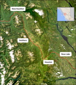
Over one hundred years ago, in 1913, the Grand Trunk Pacific Railway Company announced it would be locating an important divisional point along its transcontinental railway in a swampy townsite colloquially known as Squatterville (Figure 1).[1] After just one year, the surveyed site was transformed into a bustling town, complete with medical, educational, and financial services, and numerous business establishments. The government, private land companies, and residents promoted the area vigorously, as demonstrated by the popular slogan, “5,000 population by 1915.” While the village managed to attract only 700 residents by incorporation in 1921, by most accounts the town was flourishing.[2] Squatterville would eventually become the idyllic mountain town known as Smithers, located in the Bulkley Valley of the western central interior of British Columbia (Map 1).
Facts and figures
The Bulkley Valley is the heart of the Hudson Bay Mountain Ranges. The Bulkley Valley is divided between the Regional District of Bulkley-Nechako and Regional District of Kitimat-Stikine, and is home to several rural settlements.
| Name | Population | % Change (2016-21) | |
| Town of Smithers | 5,378 | -0.4 | |
| Village of Telkwa | 1,474 | 11.1 | |
| Village of Hazelton | 257 | -17.9 | |
| District of New Hazelton | 602 | 3.8 | |
| District of Houston | 3,052 | 2.0 |
Many of the Valley’s 16,000 inhabitants are located outside incorporated areas.
Source: Canada Census 2021
Figure 1. Early settler development, Smithers, BC, 1915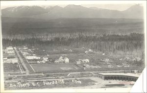
Map 1. Bulkley Valley, British Columbia.
The expansion of the railway through the Bulkley Valley was part of British Columbia’s first era of resource policy that aimed to develop the resources of Northern BC’s Crown lands. Smithers and the rest of the Bulkley Valley eventually developed through three eras of provincial resource policy, each of which is described as part of this case. After discussing the economic development of the region’s natural resources, this case highlights planning initiatives undertaken as responses to its historical pattern of resource development. These initiatives include localised resource planning, planning for local economic development, access planning, and bioregional planning.
Traditional Territory of the Wet’suwet’en[3]
The Town of Smithers was built on lands within the unceded traditional territory of the Wetʼsuwetʼen (yintah). Map 2 shows the traditional territory of the Wet’suwet’en and areas of each clan.
The peoples of the Wet’suwet’en are the original inhabitants of the Bulkley Valley. Wetʼsuwetʼen means “people of the Wa Dzun Kwuh River” (Morris and Bulkley rivers). They have occupied 22,000 km2 of traditional territory in north central interior BC since time immemorial. First contact with European fur traders is estimated to have occurred sometime in the early nineteenth century.
The Wet’suwet’en employ a hereditary governance system to guide land management on their traditional territories. This traditional governance system is based on the following five clans, which comprise thirteen house groups:
- Gilseyhu (Big Frog Clan)
- Laksilyu (Small Frog Clan)
- Tsayu (Beaver Clan)
- Laksamshu (Fireweed and Owl Clan)
- Gitdumden (Wolf and Bear Clan).
The Hereditary Chief of each house is granted the responsibility for sustaining a specific tract of house territory, based upon matrilineal inheritance of the land.[4] The Wet’suwet’en Hereditary Chiefs are also the governing authority for the Office of the Wet’suwet’en, the central agency that provides services for the entirety of the Nation, including land and resource management.
Map 2. Traditional territory of the Wet’suwet’en (approximate boundary)
Six First Nations, established by and operating under the Indian Act, govern Reserve lands within the traditional territory. The six nations are Witset First Nation, Hagwilget Village Council, Nee Tahi Buhn Band, Skin Tyee Nation, Ts’il Kaz Koh, and Wet’suwet’en First Nation.
Early Entrepreneurs of the New Economy
The early settler economy of the Bulkley Valley can be described as entrepreneurial. An entrepreneurial economy features “locally based entrepreneurs (miners, fishers, or loggers), small-scale operations, employees who may become entrepreneurs, strong local linkages, and commitment to local development.”[5] The early period of settlement was particularly prosperous for the mining industry, with widespread exploration being conducted throughout the valley. While the most lucrative deposits were invariably financed by American companies, smaller-scale exploration activities allowed local prospectors to develop deposits that were deemed unprofitable at a larger scale.
While subsistence farming was present on the landscape prior to the arrival of the railway, the allocation of 9,700 ha of agricultural lands as “settlement area” helped to transform local agriculture into a burgeoning resource industry, with valley residents soon shipping upwards of 1,000 tons of high quality grain and forage crops on an annual basis to the newly constructed grain elevator in Prince Rupert.[6] Many of these farmers supplemented their incomes by harvesting timber on their lands for use as railway ties, another mainstay of the Bulkley Valley’s early economy. By mid-decade there were hundreds of independent sawmill operations whose raw products were often purchased, processed, and shipped by local buyers in the Smithers area.
In addition to the early development of mining, forestry, and agriculture in the Valley, Smithers was selected as one of several sites for the installation of military airstrips. These activities, in combination with the area’s burgeoning retail and hospitality sectors, made Smithers an obvious choice for government and social services that served the region.
Overall, despite growth falling well short of most expectations, the entrepreneurial economy helped valley residents shoulder its early burdens through “innovative, self-directed change,”[7] which helped lay a foundation for greater diversification.
The W.A.C. Bennett Era: “Roads to Resources” (1952-1972)
By the middle of the twentieth century, the entrepreneurial economy of BC’s hinterlands was showing its limits. Although demand from national and international markets increased, the resource sectors in BC were unable to respond because they “lacked scale, secondary, and support industries, and contributed relatively little to provincial coffers.”[8] The situation started to change following the election of W.A.C. Bennett’s Social Credit party in 1952. In conjunction with similar changes at the national level, the new provincial government initiated a comprehensive strategy for “scaling up” economic expansion that focussed on two goals:
province building, by aggressively opening up BC’s hinterland resource base to multi-national corporations (MNCs); and
community building, through active investment into resource hinterlands so as to ensure “social and economic returns long into the future.[9]
As described by Young and Matthews[10], the Bennett government employed several strategies to achieve these goals, aiming to balance laissez-faire economics with interventionist policy to usher in an era of unprecedented growth. Each one of these strategies affected the Bulkley Valley.
First, the Province opened the central, northwest, and northeast regions to industrial resource development by investing heavily in transportation infrastructure throughout the hinterlands.[11] For the Bulkley Valley, this investment in infrastructure resulted in the conversion of the old military airport in Smithers into a regional airport, as well as the construction of a highway extension connecting the Bulkley Valley to Prince Rupert. Second, the government expressly encouraged consolidation of forestry operations. For example, by prioritising long-term leases when granting forest tenure on Crown lands, the government policies favoured larger firms that were better positioned to take advantage of these leases. As a result, many of the independent operators throughout the Valley either failed to have their permits renewed or had their timber quota purchased by larger companies.
The negative effect of consolidating forestry operations was somewhat softened by a package of policies that linked economic growth and social development. These included (1) appurtenancy, whereby logging and milling operations must occur within the same region; (2) utilisation requirements, which ensured a variety of tree species be harvested; and (3) minimum annual harvests, which aimed at providing rural areas with an economic base independent of market conditions.[12] Collectively, these policies aimed to capture and retain some benefits of the hinterlands within the hinterlands.
The dual mandate of linking economic growth with social development is most evident in legislative amendments that were collectively known as the “Instant Towns Act.” These amendments allowed corporations to pre–emptively purchase and incorporate remote tracts of land for the purpose of installing “planned communities” for resource industry workers. Kitimat, Chetwynd, Fraser Lake, Mackenzie, and Tumbler Ridge are all examples of this policy.
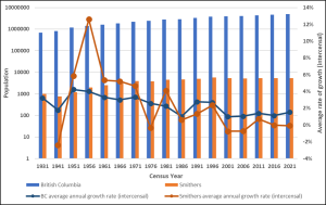
Undoubtedly, the Bennett government was successful at achieving its goal of economic expansion through improved access to resource hinterlands. From 1940-75, provincial employment in the forestry industry tripled while employment in the mining industry doubled.[13] In Smithers, residents “experience[d] a period of growth not seen since the original town site construction.”[14] These achievements were largely abetted by a post-war population boom occurring throughout the province (Chart 1), as well as across the nation and the United States.
Chart 1. Population and Annual Average Growth (%) in Smithers and British Columbia (1931-2021)
Despite the many economic benefits, resource policy during this period was not without criticism. It was suggested that the Bennett administration’s insistence on prioritising unprocessed commodity goods severely undermined rural economic diversification, a feature that persists to this day.[15] Furthermore, this era was marred by a flagrant disregard of non-market values, and in particular, of Indigenous rights and environmental interests. This indifference is perhaps best illustrated by the 1963-68 construction of the W.A.C. Bennett Dam in northeast BC, an enormous hydroelectric power station designed to provide affordable electricity to BC residents and, in particular, the Greater Vancouver area. The resulting Williston Reservoir, now the largest water body in BC, had, and continues to have, a traumatising impact on the Indigenous peoples of the Peace and Finlay River Valleys. As part of the Province’s relocation effort, entire Indigenous villages were set ablaze while corpses were brusquely exhumed and dumped into mass graves.[16] As described in a 2007 report:
…[T]he [Bennett] dam flooded not only a 168 acre reserve but [also] 640 square miles of productive Tse Keh Nay traditional territory. The old settlement of Fort Grahame ceased to be. Villages, sacred sites, hunting grounds, and trap lines were flooded and it was the end of hunting, fishing, trapping, and life as they knew it.[17]
After the reservoir was filled, it is not known how much wildlife drowned during the spring flooding, though estimated losses are substantial.
The Post-Bennett Era: Downloading and Deregulation (1972-1989)
The coalition of government, multi-national corporations, and labour unions proved a robust partnership during the Bennett era that fostered the dramatic growth in natural resource extraction. If this Bennett “model for development involved the hand-in-hand expansion of rural industry and community, the foremost aim of the…[new] strategy is to disaggregate these.”[18]
The post-Bennett era of resource policy continued to promote reliance on northern BC as a “resource bank” to support industrial and technological growth in core metropolitan regions. It can also be described as an era of downloading and deregulation. In the pursuit of flexible modes of production, resource industries were increasingly relieved of their corporate social responsibilities, specifically those relating to social development. Thus, this era may be described as a “plantation model,” where resource exploitation is
…by foreign-owned [corporations], capital intensive, and while labor is well paid (in relation to local standards), job tasks are highly specialized and designed to extract a resource for use in the parent company’s operations elsewhere. The business linkages of the plantation model (value-added, services, equipment, profit flows) are primarily international rather than local….[19]
The general direction of the post-Bennett era policy can be described using three guiding principles:
- the minimisation or removal of market and regulatory constraints for resource industries;
- a shift from strategic corporate investment towards promotion of municipal entrepreneurship in resource peripheries; and,
- a centralisation of provincial administrative duties.
Perspective: Dr. Raymond Chipeniuk, RPP (retired), Resident of Smithers
However, by the mid-1970s, several factors forged a new era of resource policy.[20] These factors included a provincial recession, a contentious US-Canada softwood lumber dispute, increasing globalisation of world commodity markets, and pressure from various opposition/advocacy groups.
By 2003, a new era of provincial policies for Crown lands was fully formed. The Forestry Revitalization Plan (2003) abolished the appurtenance policies that were designed to link extractive industries with regional economies, ostensibly for serving as disincentives to forestry operations. The Forest and Range Practices Act instituted “results-based” objectives that allowed industry to develop forest management plans and practices without public oversight, thereby decreasing regulation pertaining to environmental values. Also, whereas provincial regulators were previously granted exclusive authority for administering forest tenure, forestry operators were now able to subdivide, trade, or transfer lease rights without ministerial approval.
The BC Heartland Economic Strategy introduced legislation to streamline administration and stimulate investment in mining. This legislation provided mineral prospectors with unobstructed right of entry to 85% of the provincial land base for exploratory activities. As Premier Campbell stated, the desired effect of this strategy was to “open up the heartland of our province” and “to make sure the [rural and northern] communities that built this province share fully in the opportunities and prosperity in British Columbia’s future.”[21]
Perspective: Jason Llewellyn, MCIP RPP, Director of Planning, Regional District of Bulkley-Nechako
This era of Crown land planning had several unintended consequences for the Bulkley Valley. Corporate investment shifted out of the hinterlands to larger urban centres, resulting in many layoffs and mill closures throughout Northern BC.[22] The downsizing of ministerial responsibility eliminated several service offices throughout the hinterland, including the Forest Service’s regional headquarters office in Smithers.[23] To compensate for this withdrawal, rural municipalities were increasingly encouraged to apply for government funding framed as “community development initiatives.” Examples of these initiatives included Northern Development Initiative Trust, Community Forest Programs, and Rural Development Initiative.
Land Use Planning in the Bulkley Valley
Land use planning in the Bulkley Valley has been described as “a rough quiltwork; sometimes there are comfy layers upon layers and sometimes there are disturbing gaps.”[24] This quiltwork is due to the multitude of government agencies asserting jurisdiction throughout the valley overlaid by Indigenous rights and titles. This quiltwork includes the following:
- First Nations;
- Office of the Wet’suwet’en and Gitxsan Chiefs’ Office;
- Ministry of Forests[25], a provincial agency charged with developing new plans for the management of Crown land and natural resources as well as the maintenance of BC’s existing land use planning legacy;
- Ministry of Transportation and Infrastructure (MoTI), which, among other things, is responsible for rural subdivision approvals;
- Several municipal governments; and
- The Regional District of Bulkley-Nechako and Regional District of Kitimat-Stikine, which are responsible for statutory plans and zoning, and administer private land holdings in unincorporated areas.
In addition, private tenure holders (forestry, mining, recreation) are responsible for developing plans at a variety of spatial scales which may or may not require public participation for plan approval. Finally, there exists a multitude of non-government organisations that directly and indirectly contribute to the planning dialogue occurring throughout the Valley.
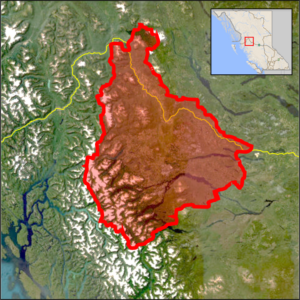
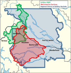
Map 3 illustrates an example of three overlapping jurisdictions. These include the traditional territory of the Wet’suwet’en, the geo-political boundary of the Regional District of Bulkley-Nechako, and the boundary of the provincial Bulkley Land and Resource Management Plan (Bulkley LRMP).
Map 3. Overlapping jurisdictions
The difficulty of overlapping jurisdictions in British Columbia is described in the introduction of the province’s publication A Practical Guide to Effective Coordination of Resource Tenures, as follows.
The Province of British Columbia, through various ministries and agencies, issues leases, licences, SRW (statutory rights of way), and permits (all commonly referred to as: tenures) for commercial use of natural resources. In all regions of the Province it is not uncommon for several tenures to apply over the same area of land. The Province adheres to a policy of integrated resource use, whereby several activities may occur on the same land base, provided they are coordinated and meet the requirements for long‐term sustainable management and are consistent with BC Government goals.[26]
This guide helps readers understand how and why multiple tenures can exist in the same land base, and to help people take steps to avoid disputes that can arise under these circumstances. These steps include recognising a balance of responsibility among all tenure holders while also understanding the limitations of the tenures. Learning about the relevant legislation and regulations is essential.
The Province makes every effort to ensure that resource management is coordinated, and that tenured activities will not negatively affect public interests or other rights. Tenures are written to be very specific about the rights or privileges they convey. There is an expectation that tenure holders where applicable will make reasonable efforts to accommodate the interests of other resource users. Reciprocal accommodation is the foundation of successful, integrated resource use.
Among these overlapping jurisdictions, the potential for conflict is significant and real. Several factors identified by the province explain why:
- A combination of surface and sub‐surface resources;
- Different terms and conditions, interests, and obligations in tenures;
- Both general and specific area tenures;
- A number of different companies and persons, each holding one or more tenures;
- Potential impacts on one tenure holder when another exercises their rights; and,
- Changing land use expectations and demands.[27]
Regional-scale development of provincial and national interests do not always align with local interests, and conflicts over pipelines have brought Indigenous rights and title to national attention. A series of critically important court decisions[28] have recognised not only Indigenous rights and title but have also worked toward establishing legal obligations for prior and informed consent through meaningful consultation.
It is amidst the “quiltwork” of land use planning policies with which we describe planning initiatives aiming to assert greater influence over Crown land use decisions in the Bulkley Valley. At this local scale, land use conflicts can be especially pronounced in the “interface” zone–the ill-defined transition zone of Crown land surrounding municipalities. Some of the present concerns in the Bulkley Valley that are related to these interface lands reflect the interests of resource towns and incorporate a broader range of resource values (recreation, aesthetic, spiritual, etc.) into management practices. The Office of the Wet’suwet’en and residents of the Bulkley Valley are among those striving to assert greater local control over Crown lands. In particular, the Wet’suwet’en continue to assert their traditional title and rights over Crown land. As well, the Bulkley Valley Community Resources Board (BVCRB) helped create the Bulkley LRMP.
Indigenous rights and title
McCreary’s report on the “shared histories” of Witsuwït’en-settler relations describes a historical process of appropriation and exclusion in the Bulkley Valley.[29] McCreary describes the following conditions of colonial displacement:
If some Witsuwït’en families occupied the Smithers area prior to settlement, others came to Smithers because of colonial policies. While provincial land policies created opportunities for settlers to claim the land, it limited First Nations people who were both denied title and refused the right to claim land like the settlers. Instead, First Nations space was bounded to a set of small reserves. While numerous Witsuwït’en families sought to homestead land, they struggled to achieve legal recognition by settler authorities. Many families were forced from their homesteads. Some moved to newly created reserves while others came to town poor and dispossessed.[30]
To counter oppression and dispossession, the Wet’suwet’en have taken an assertive approach towards improving local control over resource decisions through a variety of means, including litigation, planning, and grassroots action. Perhaps most significantly, the Wet’suwet’en and Gitxsan First Nations won a landmark case in the Supreme Court of Canada, known as the Delgamuukw decision, which established oral history as evidentiary proof of Indigenous title and rights. Moreover, the ruling provided a broader interpretation of asserted rights that defines rights in relation to “all things pre-contact.”
The precedent established by Delgamuukw was instrumental in the Office of the Wet’suwet’en’s opposition to a controversial coal-bed methane proposal near Telkwa in 2006. Wet’suwet’en Hereditary Chiefs assumed a leadership role in a valley-wide grassroots campaign to obstruct the unwanted development, most visibly through a press conference at Norwest Corporation’s headquarters in Calgary, AB, as well as a well-attended ‘Rally for the Valley’ protest in Smithers.[31] Following their successes in the Bulkley Valley, the Wet’suwet’en Hereditary Chiefs passed a First Nations Summit resolution that called for a 10-year moratorium on all coal-bed methane development within BC.
The Office of the Wet’suwet’en was also the chief agency responsible for developing the Wet’suwet’en Territorial Stewardship Plan, a “decision-making tool based on the vision of the Hereditary Chiefs and clan membership…designed to develop a comprehensive spatially linked database of Wet’suwet’en cultural and ecological information and values at the House territory level.”[32] As Rick Budhwa explains, the plan captures and translates Wet’suwet’en oral history, and other media of information transfer, into a GIS database that aggregates data into a “significance scale” of low, moderate, or high value. The specific criteria for determining significance are unique to each house territory. While limited financial resources had not allowed for input of ecological data, cultural values embedded in the plan were used for archaeological assessments conducted on Wet’suwet’en territory and informed the Morice River Management Plan. The Wet’suwet’en circumvented government agencies and offered the plan directly to resource industries, allowing for (1) earlier consultation with the Wet’suwet’en in development assessments, and (2) culturally-sensitive regulation of Wet’suwet’en lands. Moreover, as Budhwa explains, joint consultation agreements between the Wet’suwet’en and local firms created opportunities for economic development and capacity building with each investigation.
The serious conflict over the Coastal GasLink Pipeline, which crossed 190 kilometres of the Wetʼsuwetʼen territory, highlighted the critical need to understand relations among band councils, hereditary chiefs, and different levels of Canadian government. In February, 2020, the Office of the Wet’suwet’en and the governments of Canada and British Columbia signed a Memorandum of Understanding (MOU) that affirmed the following:
- that Wet’suwet’en rights and title are held by the Wet’suwet’en Houses under their system of governance (Anuk Nu’at’en); and
- that Canada and BC recognise Wet’suwet’en title and rights throughout the yintah.
Work to implement the MOU continues among all three governments.
Learning Modules
Integrated resource management
Throughout the post-war era, the BC ministry responsible for forests exercised unparalleled authority in managing forestry practices over 94% of the provincial landmass, while also determining the appropriate level of public involvement in planning. Meanwhile, area residents became increasingly vocal about their dissatisfaction with the lack of public input. In the Bulkley Valley, local unrest came to a head in 1990 when the Bulkley Forest Service announced that it would be developing a 20-year Forest Lands Management Plan for the Bulkley Timber Supply Area. Fearing that such a plan would be completed without meaningful public input, Valley residents sought to reclaim their forests. The first step was to form a regional steering committee to deal with the Forest Service office.
With the aid of a facilitator, members of the steering committee and the Forest Service negotiated the terms for public involvement during the planning process. The most important element of these terms was an agreement to form the Bulkley Valley Community Resources Board (BVCRB). Open selection of BVCRB members was based upon a candidate’s qualifications in representing one of 16 perspectives (e.g., “values timber production above other uses,” “values the maintenance of large tracts of wilderness”). This selection process was said to increase representativeness while avoiding the adversarial interactions sometimes fostered by sectoral or interest-group representation.
The establishment of the BVCRB loosely coincided with the inauguration of a new provincial government, whose election promises included the development of a province-wide, comprehensive land use planning process that would incorporate explicit requirements for public participation. This provincial resource planning policy direction was consistent with the sentiments of many Bulkley Valley residents who believed that “when it comes time to make decisions…everyone should have the right to be an expert. Value judgments should be made by those representing the community perspective, not a technical agency.”[33]
Through various outreach campaigns, the BVCRB generated significant public support from Bulkley Valley residents, forcing ministerial agencies to surrender considerable influence throughout the process. Most importantly, the BVCRB became the primary agency responsible for drafting the Bulkley LRMP using a consensus-based process for making decisions. An Interagency Planning Team (IPT), composed of government representatives, was organised to work alongside the BVCRB in providing technical and administrative support.[34] The BVCRB and the IPT were divided into subcommittees in order to develop four distinct land use management scenarios for public review. Attendees of the scenario workshops were asked to identify particular components of each scenario that satisfied their particular land use vision for the Bulkley Timber Supply Area[35]. Based on this information, the BVCRB was tasked with negotiating consensus on management direction for each landscape unit, eventually culminating in the draft Bulkley LRMP. The document was presented to the IPT, the public, and the provincial government, who eventually ratified the plan with only minor revisions.[36]
Perspective: Dr. Raymond Chipeniuk, retired RPP, resident of Smithers
Since approval of the Bulkley LRMP in 1998, the BVCRB has maintained an active role in implementing, monitoring, and amending the plan, while also devoting resources to other management projects, including the 2005 Bulkley Valley Sustainable Resource Management Plan (SRMP). While government enthusiasm for LRMPs waned over time, the BVCRB remains an important agency for ensuring land use decisions made in the Bulkley Valley adhere to objectives established in the Bulkley LRMP.[37] By promoting and adhering to principles of transparency, accountability, representativeness, and consensus, organisers were able to acquire sufficient public support and to transform this support into decision-making power at various planning tables.
Learning Module
Recreational access planning
The need to co-ordinate access to Crown land for recreational purposes is a long-standing issue in the Bulkley Valley. There are currently around 400,000 to 550,000 km of resource roads in BC and a seemingly unknowable number of backcountry paths and trails, which exist with little regulatory oversight and no comprehensive inventory concerning their number, location, and status.[38] In areas of high recreational value, such as the Bulkley Valley, this lack of regulatory oversight may compromise opportunities to promote recreational tourism, encourage land use conflict between resource users (e.g., motorised versus non-motorised recreation), and lead to increased environmental degradation and habitat fragmentation.
During the creation of the Bulkley LRMP, the establishment of a Recreational Access Management Plan (RAMP) was a chief priority for the planning table. The negotiations were said to be weighed heavily in favour of motorised users, since ATVers and snowmobilers may directly impede non-motorised activities but are relatively unaffected by skiing, hiking, etc. Notwithstanding such differences, consensus was achieved on zoning designations (e.g., summer or winter, motorised or non-motorised) for the majority of backcountry destinations. However, a lack of a dispute resolution protocol led to three highly contested backcountry areas being designated as “unresolved.” Since the adoption of the Bulkley LRMP, user conflicts in these areas have resulted in five formal complaints to the Forest Practices Board. Through its responses, the Forest Practices Board has continuously advocated for a completed recreational access management plan in the Bulkley Valley.
Perspective: Dr. Raymond Chipeniuk, retired RPP, resident of Smithers
Government funding and staff resources for projects such as the Bulkley Valley RAMP are almost non-existent. Thus, it is only through the perseverance of concerned citizens that the RAMP was completed[39]. Informal agreements resolved disputes in two of the three contested areas; although, predictably, enforcement continues to be an issue.[40] In the absence of an access plan, provincial authorities have relied almost exclusively upon voluntary compliance. And problems continue to exist, even in areas with designated zoning. As a result of the continued efforts of Valley residents, the BC government hired a consultant to draft a process proposal for establishing consensus on summer and winter use access plans. In 2013, the BVCRB adopted a Summer Recreation Access Management Plan. No winter plan has been developed.
Perspective: Jason Llewellyn, MCIP RPP, Director of Planning, Regional District of Bulkley-Nechako
The planning department for the Regional District of Bulkley-Nechako deals primarily with land use and development in areas of human settlement. The planning department prepares and implements plans, policies, and regulations to guide community development in the public interest. The Regional District’s planning does not include planning for the use of Crown lands with regards to areas of provincial jurisdiction (forestry, mining, recreation, etc.) or other issues addressed through the LRMP process. However, there are select circumstances where the Regional District may become involved in issues relating to Crown land. Examples are as follows:
- Use of Crown land by private interests for uses such as wind farms, remote resort development, recreational lot subdivision, etc.;
- Participation in Environmental Assessment processes as a stakeholder; and,
- Review and comment on tenure applications being considered by the province.
Media Attributions
- Figure 1. Early settler development, Smithers, BC, 1915. © Bulkley Valley Museum is licensed under a CC BY (Attribution) license
- Map 1. Bulkley Valley, British Columbia © Government of British Columbia is licensed under a Public Domain license
- Map 2. Traditional territory of the Wet’suwet’en and areas of each clan (approximate boundary) © Government of British Columbia is licensed under a CC BY (Attribution) license
- Chart 1. Population and Annual Average Growth (%) in Smithers and British Columbia (1931-2021) © Source: Statistics Canada
- Map 3. Overlapping jurisdictions is licensed under a Public Domain license
- Shervill, R L (1981). Smithers, From Swamp to Village, Smithers, BC: Town of Smithers, p. 19. ↵
- Shervill (1981), p. 25. ↵
- The information about the Wet’suwet’en peoples is drawn from the Office of the Wet’suwet’en ↵
- Budhwa, Rick. "An Alternate Model for First Nations Involvement in Resource Management Archaeology." Canadian Journal of Archaeology 29 (2003): 20-45. ↵
- Hayter, Roger (2000). "Single Industry Resource Towns." In A Companion to Economic Geography, Eric Sheppard and Trevor J. Barnes, eds., Malden, Mass.: Blackwell Publishers Ltd., p. 294. ↵
- Shervill (1981), p. 75. ↵
- Hayter, R., and T. J. Barnes (2001). "Canada's Resource Economy." Canadian Geographer 45, no. 1, p. 37. ↵
- Markey, S., Halseth, G., & Manson, D. (2008). Challenging the inevitability of rural decline: Advancing the policy of place in northern British Columbia. Journal of Rural Studies, 24, p. 412. ↵
- Markey et al. (2008), p. 414. ↵
- Young, Nathan, and Ralph Matthews (2007). "Resource economies and neoliberal experimentation: the reform of industry and community in rural British Columbia." Area 39(2): 176-185. ↵
- Young and Matthews (2007). ↵
- Young and Mathews (2007). ↵
- Young and Matthews (2007), p. 178. ↵
- Shervill (1981), p. 128. ↵
- Markey et al. (2008), p. 414. ↵
- Littlefield, Lorraine, Linda Dorricott, and Deidre Cullon (2007). "Tse Keh Nay Traditional and Contemporary Use and Occupation at Amazay (Duncan Lake): A Draft Report." Draft Submission to the Kemess North Joint Review Panel, p. 45. ↵
- Littlefield et al. (2007), p. 44. ↵
- Young and Matthews 2007, p. 180. ↵
- Hayter (2003), p. 294. ↵
- Hayter, Roger (2003). ""The War in the Woods": Post-Fordist Restructuring, Globalization, and the Contested Remapping of British Columbia's Forest Economy." Annals of the Association of American Geographers 93, no. 3, pp. 706-729. ↵
- Government of BC (2003). “New Heartland Economic Strategy to Open Up BC.” Media Release, Feb. 11, 2003. Victoria, BC. ↵
- Young, N., and R. Matthews (2005). "The economic spaces of community and industry in rural British Columbia: the political reconstitution of a rural economy." Area (draft copy), p. 12. ↵
- Parfitt, B (2010). Axed: A Decade of Cuts to BC's Forest Service. Canadian Centre for Policy Alternatives. ↵
- Valley Vision. "What plans do we have and will they achieve our vision?" Bulkley Valley Centre for Natural Resources Research and Management. ↵
- Formerly: Ministry of Forests, Lands, Natural Resource Operations & Rural Development; Integrated Land Management Bureau (ILMB). ↵
- Government of British Columbia (2008). A Practical Guide to Effective Coordination of Resource Tenures, p. 6. ↵
- Government of British Columbia (2008). A Practical Guide to Effective Coordination of Resource Tenures, p. 6. ↵
- Including R v Sparrow, [1990] 1 S.C.R. 1075; Delgamuukw v British Columbia, [1997] 3 SCR 1010; Tsilhqot'in Nation v British Columbia, [2014] SCC 44. ↵
- McCreary, Tyler (2017). Shared Histories: Witsuwït’en-settler relationships in Smithers, 1913-1917. Smithers, BC: Office of the Wet’suwet’en, Town of Smithers, Florida State University. McCreary uses Witsuwït’en exclusively. Wet’suwet’en appears to be a contemporary spelling. ↵
- McCreary (2017), p. 5. ↵
- Ardis, Larissa. "Angry BC Chiefs Confront Calgary Corporate Honchos." The Tyee, 24 November 2006. ↵
- Budhwa (2003), p. 28. ↵
- Giesbrecht, Kelly (2003). Public participation in resource management: The Bulkley Valley Community Resources Board. Dissertation: University of Northern British Columbia, p. 123. ↵
- Integrated Land Management Bureau (1998). "Bulkley Land and Resource Management Plan." The Province of British Columbia, p. 23. ↵
- The visions of these scenarios workshops were published as summary documents. ↵
- Halseth, Greg, and Kelly Giesbrecht (2003). Public Participation in Resource Management: The Bulkley Valley Community Resources Board. Vol. 1. Prince George, British Columbia: Northern Land Use Institute, University of Northern British Columbia. ↵
- Current information about BVCRB and its projects are available on its website. ↵
- Forest Practices Board (2005). Access Management in British Columbia Issues and Opportunities. Special Report #23, p. 1. ↵
- Recreational Access Management Plan. ↵
- Integrated Land Management Bureau (2006). "Current Recreational Access Agreements: Bulkley TSA." ↵

Feedback/Errata