Case. Ancient Forests of the Upper Fraser
PROTECTED AREAS CASE STUDY
Learning Objectives
The ancient forests of the upper Fraser River watershed are part of a globally-unique ecological system known as British Columbia’s interior temperate rainforest. This case provides context for why the ancient cedars should be protected under provincial land use policy. Examined from multiple perspectives, this case weaves together the interests of recreational hikers, conservationists, scientists, and policy-makers. Learners should pay attention to the interplay between land use policy and an emerging understanding of the scientific significance of this ecosystem. The story presented in this case ends before the province made a decision about how to protect these ancient forests.
Unceded traditional territory of the Lheidli T’enneh
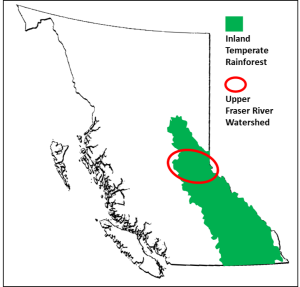
British Columbia’s inland temperate rainforest is over 500 kilometres from the coast (Figure 1). Globally, this is unique. Typically, rainforests exist along coasts where moisture-laden winds from the ocean soak lush forests, making them rich in biodiversity and beauty. Rainforests exist inland where conditions are just right. The rarity of such conditions make inland temperate rainforests special.
Figure 1. Location of BC’s inland temperate rainforest
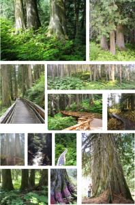
The scenery is also very striking, with very large trees covered in lichen and moss and a forest floor blanketed with ferns, Devil’s Club, and other vegetation. In the ancient stands of the upper Fraser River watershed, trees are three or more metres in diameter.[2] The oldest trees are estimated to be 1,000 years or more, and perhaps up to 2,000 years. The largest documented tree, the tree along the Ancient Forest Trail known as “Big Tree,” measures 4.13 m in diameter.
Not only are individual trees old, so is the forest itself. The absence of natural disturbances, such as wildfire, landslides, and avalanches, means that some of these stands have not been disturbed for a long time. Among biologists, “ancient forests” denote stands of trees that have been in place for 1,000 years or more.[3] This is why people who know these trees refer to them as the Ancient Forest. In the Lheidli dialect of the Dakelh language, chun t’oh whudujut refers to the “oldest trees.”
Block 486[4] is a film about these stands of ancient cedar trees. The title of the film refers to the number of a forest licence held at the time by a local forestry company that produced cedar rails and posts for gardens, with byproduct sold as garden mulch. Block 486 contains some of the biggest, oldest trees in the watershed.
The film was released publicly at a screening in Prince George in November, 2006. After the film was shown, the floor was opened for questions with the film’s producer, Richard Olak. David Radies, a graduate student at the University of Northern British Columbia (UNBC) who was studying the ancient cedars for his Master’s degree, was in the audience. Radies’ profound question seemed to capture what many people in the room were thinking: “Why are we turning thousand-year old cedars into garden mulch?”
The film strikes at the heart of protected areas: When is a natural area worth protecting? What users, interests, and values must be considered?
Globally-unique ecosystem [5]
The global significance of the forest’s ecological value was first documented in 1994 by Trevor Goward[6], which makes this a relatively new scientific discovery. As explained by Coxson, Goward, and Connell, the weather systems that support rainforests on BC’s west coast are also responsible for a secondary zone that supports the inland rainforest as the weather systems cross interior mountain ranges. The result is a zone of high precipitation, most of which falls as snow in the winter.
According to BC’s Biogeoclimatic Ecosystem Classification (BEC) system[7], the inland temperate rainforest is in the Interior Cedar-Hemlock (ICH) zone. Among the ICH subzones, the ancient forests of the upper Fraser River are in the very wet (v) and cool (k) subzones (ICH vk), largely due to its geographic location in the lower slopes of the Columbia and Rocky mountains.
In this very wet, cool zone, the high-level snowpack is the essential source of water for the ancient cedars throughout the year. In the spring and summer, the melting snowpack migrates downslope, picking up nutrients along the way, and feeding the forest systems downslope. In particular, the water pools in toe slope areas, providing ideal conditions for what have become impressive stands of very large, old western redcedar.
Although people are readily impressed by the size and beauty of the cedars, the canopy of the ancient forest is also home to rich biodiversity[8]. A scientific assessment of biodiversity of a small sample of the area identified more than 900 species, some red- and blue-listed species (endangered or near extinction in B.C. or even globally).[9]
Importantly, the climatic conditions that create ideal conditions for the cedar also suppress stand-level wildfires. When lightning strikes, only a few trees might catch fire; the wet conditions prevent the fire from spreading (as evident in Figure 2). However, the stands will be subject to future impacts of climate change, which are largely unknown.
Figure 2. Western redcedar burning a few days after a lightning strike
Traditional uses of the Lheidli T’enneh [10]
Chun t’oh whudujut,[11] the “oldest trees,” are important to the Lheidli T’enneh. The stands of western redcedar are tied to their cultural practices and traditions and were sources of medicinal plants. The Lheidli visited the stands from summer fishing camps along the upper Fraser River.
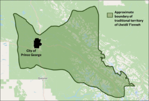
The traditional territory of the Lheidli T’enneh (Figure 3), an area of over four million hectares, covers a diverse landscape. Significantly, the Fraser River traverses the whole of their area traditional territory, which also covers portions of the Rocky Mountains and Caribou Mountains, and extends to the BC-Alberta border. The rivers and river valleys are essential to travel, trade, and culture based on hunting, fishing, trapping, and gathering.
Figure 3. Traditional territory of the Lheidli T’enneh (approximate boundary)
Within their territory, the areas where the Lheidli T’enneh lived and their activities varied by season. During the winter months, larger groups of the Lheidli T’enneh lived in semi-permanent villages of pit houses. In other seasons, family groups lived at seasonal camps throughout their traditional territory. Although these seasonal camps varied from year to year, family groups returned to key sites along rivers for salmon, on lakes for fishing in the spring, and in the mountains for hunting in the fall.
In recent years, the Lheidli T’enneh signed several economic benefit agreements with the Province of BC. These agreements aimed to ensure that Lheidli T’enneh would more fully benefit from the natural resources within their traditional territory while enhancing their social, economic, and cultural well-being of their members. In 1997, the Lheidli Nation established LTN Contracting Ltd., a timber harvesting company operated as a joint venture with Roga Contracting Ltd. The forest agreements have covered replaceable and non-replaceable licences as well as revenue sharing. Although the areas covered by these agreements include stands of ancient cedars, the focus of logging is in deciduous-leading harvest areas. In the Forest Tenure Opportunity “A&B” Agreement[12] signed in 2011, the Lheidli T’enneh have access to 101,888 cubic metres annually via non-competitive bid, with a maximum volume of 509,440 over five years. The Forest Consultation and Revenue Sharing Agreement[13], signed in 2018, provides the Lheidli T’enneh with a portion of provincial revenues derived from timber harvesting with their traditional territory.
European history and the ancient cedars
The Lheidli T’enneh have lived among the ancient forests for thousands of years. For others, the value of this unique landscape has been “discovered” several times in various forms. Alexander Mackenzie travelled through Lheidli territory in 1793 and was followed by Simon Fraser in 1808. A major incursion by non-Indigenous peoples was the Grand Trunk Pacific Railway, which started in Winnipeg and led to Prince Rupert. In 1911, the construction crew crossed the Alberta/BC border and then into the watershed of the upper Fraser River. Construction of the railway was completed in 1914.
From a European settler perspective, the upper Fraser River watershed was a remote, bustling area. In her book on the history of the area, Marilyn Wheeler notes a brochure from 1914 promoting the area as the “new garden of Canada.”[14] Another early account described the area as a “picture of tremendous beauty,” but also an “eerie forest” that looked like “the Devil’s Cathedral.”[15]
The next major incursion through the upper Fraser was the highway, completed in 1968. Highways tend to be constructed on the toe slopes of mountain areas. Unfortunately, as discussed above, these toe slopes are also prime areas for ancient stands of cedars. When the highway was built, it tended to be built through these stands, which is evident as one drives through the valley, seeing cedars on both sides of the highway.
Stevenson et al.[16] describe the historical development of logging in the inland temperate rainforest, including the stands of ancient cedars. Throughout the early days of settlers, logging was a daily chore, occupied with harvesting wood for buildings and fires. Small-diameter cedar was harvested regularly for poles; the outer shells of larger-diameter trees were used for shakes, shingles, fence posts, and fence rails. Over the many years since, harvesting focused primarily on white spruce, Douglas fir, and subalpine fir, with redcedar constituting only a relatively small percentage of total volume logged.[17] Notwithstanding their lower economic value, cedars remain a source of valuable shakes, shingles, posts, and rails. Harvesting and processing tended to be done by smaller companies. Over time, the volume of western redcedar harvested declined dramatically, yet remains a specified component of harvest quotas.[18]
As Wheeler documents, prior to the highway, the valley was dominated by small mills. The new highway, however, opened the valley to a greater flow of people and products, including logs. As more logs were trucked out of the valley to Prince George, the local mills closed. Although cedar posts and poles continued to be shipped out of the area, the stands of giant cedars were not a prime area for logging. The larger cedars have hollow centres and tend to shatter when felled, thus reducing their economic potential while increasing harvesting costs. Although the low-timber value of the giant cedars meant that most areas were not logged extensively, the greatest impact on stands of ancient cedars was the construction of the highway through the valley.[19]
There are a few small and medium-sized companies in the McBride area that are harvesting and processing western redcedar. Midget Mills is a second-generation family-owned and -operated custom saw mill using locally-harvested logs. In addition to western redcedar, they saw spruce, balsam fir, pine, Douglas fir, hemlock, poplar, and birch. For more than two decades, Cedar 3 Products produces split post and rail fencing, cedar bark mulch, and custom cedar furniture.
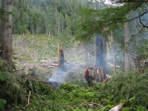
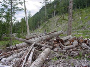
TRC Cedar also operated in the area, employing about 40-50 people. Using a more aggressive approach, TRC Cedar acquired volume-based licences to harvest looper-killed hemlock. When the market for salvaged hemlock dropped almost immediately and significantly, TRC Cedar requested permission to cut green wood and less salvage stands, including the cutting of “damaged” (i.e., low timber value) ancient cedars stands. The request was approved as a desirable balance between the salvage objective and maintaining local employment opportunities, thereby establishing the timber value of the ancient cedars as a priority. The government policy at the time viewed cedar as a “decadent” species that should be harvested and replaced by other faster-growing species.[20] Most of the stands that TRC Cedar had identified for logging included the oldest, biggest, and most ecologically-significant stands of cedar. Their license included Block 486, which was the focus of the film. Block 482 is located a few kilometres west of Block 486 and was clear-cut around 2007 (Figure 4). In February 2008, TRC sold its forest licence to harvest the cedar-hemlock stands; the volume was transferred to beetle-attacked pine stands in the southern interior.
Figure 4. Block 482, clear cut
A few years after TRC ceased operations, the gap in the local market was filled by BKB Cedar Manufacturing, which was established in 2013. BKB manufactures cedar post and rail fencing, as well as mulch and wood chips.
The McBride Community Forest Corporation (MCFC) has operated in the valley since 2007. The company, which is wholly-owned by the Village of McBride, has exclusive rights to harvest timber from an area surrounding the village. Under a Community Forest licence, the primary aims are to stimulate local economic activity and provide a monetary return to the village and its residents. Spruce (41%) is the dominant species within the MCFC timber supply area, with subalpine fir (17%) and other species present. Western redcedar covers 16% of the area and is part of MCFC’s harvest plans.
Recreational values
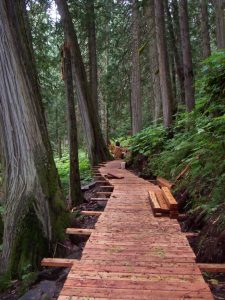
Access to the ancient forest was enhanced greatly when the Ancient Forest Trail was built. The trail was born from collaboration and coincidence. In 2005, a group of local residents from the Dome Creek area wanted to improve recreational access to stands of ancient cedars in the area. At the same time, members of the Caledonia Ramblers Hiking Society, a group of volunteers based in Prince George, were exploring ways to improve access to the Driscoll Ridge trail, which they maintain. Both groups were considering a new trail in the area of TRC Cedar’s Block 486. Figure 5 shows the first sketch of the proposed trail (dark blue line); it also shows the boundary of Block 486 (solid pink line) and a proposed access road for the logging operation (pink crosses). After getting permission from the province, the Ancient Forest Trail, a 2.5 km interpretive trail (Figure 6) built by volunteers (Figure 7), opened officially on June 4, 2006, the same year that the film Block 486 was released.
Figure 5. First sketch of proposed trail
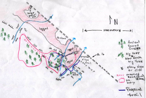
Figure 6. Ancient Forest Trail map
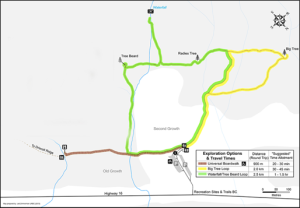
Figure 7. Nowell Senior Universal Boardwalk under construction, part of the Ancient Forest Trail.
Around this time, David Radies was conducting research on biodiversity in the area. During one of his trips into the stands of ancient cedar, Radies found flagging tape and markings on the trees in Block 486. Concerns rose immediately among local residents, scientists, and recreational users that the ancient cedars would be harvested within weeks. The threat remained until TRC Cedar sold its licence.
In November, 2008, a Recreation Order established the Ancient Forest Trail as an interpretive site and the Driscoll Ridge Trail as a recreation trail. The Order was established under section 56(1) of the Forest and Range Practices Act.
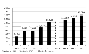
It did not take long after the trail opened for word of the ancient cedars to spread. Visits to the trail increased dramatically. Estimates of visits to the Ancient Forest Trail indicate growth from 4,749 visits in 2008 to almost 15,000 visits in 2016 (Chart 1).
Chart 1. Ancient Forest Trail, estimated users (summer hiking season, 2008-2016)
The Ancient Forest Trail has been walked by visitors from around the world. According to entries made in the visitor’s book at the trail head, visitors represent 12 Canadian provinces/territories, 28 states of the USA, and 26 countries outside North America.
Learning Module
Policy Development
The ancient forests of the upper Fraser River watershed are located on Crown lands, areas that are owned and managed by the Province of British Columbia. The management of these lands is governed by relevant provincial legislation such as the Forest and Range Practices Act and the Park Act. Within this policy regime, the aim is to maximise the timber value based on sustainable levels of harvesting and the primary means for allocating land uses is through timber supply analyses. Little priority is given to the non-timber forest values of the ancient cedars.
Since 1999, there have been several important developments regarding land use policy in the valley of the upper Fraser River. The development of comprehensive regional land use plans, which began in the 1990s, provides a starting point. At that time, the Province of BC revised its land use planning processes with the aim to incorporate more non-commercial values such as wildlife, tourism, and culture. This change centred on the development of Land and Resource Management Plans (LRMPs) that would govern all activities on public land.
The Prince George LRMP (1999) and the Robson Valley LRMP (1999), which cover most of the ancient cedar stands, were intended to help guide forest development and established new protected areas. Although stands within the cedar-hemlock forests are valued as old-growth forests in the Prince George LRMP, and the plan included specific objectives for biodiversity and maintaining rare and common habitats, there is no mention of other special values associated with the ancient cedars. The Robson Valley LRMP states only, “Some of these cedar-hemlock forests are more than 500 years old and have areas with a variety of macrolichen species.”[21] The LRMPs did lead to the designation of provincial parks that had specific objectives to protect some stands of old-growth cedar-hemlock.
Learning Modules
Coxson, Goward, and Connell[22] discuss land use policy governing old-growth stands. As they explain, stands of ancient cedars within the upper Fraser River watershed had been managed as part of the timber harvesting land base with the implicit or explicit objective of sustained timber production over time. As stated by the province’s Chief Forester, it is “important to maintain old growth redcedar on the landscape for future generations and to meet requirements to manage old growth in the ICH.”[23]
According to the provincial government’s 2004 “Old Growth Order,” 53% of upper Fraser forests was to be maintained as old forests.[24] However, the status of this old growth order in the Prince George Timber Supply area is uncertain. Recommendations from the review of the mid-term timber supply state that “it is possible to increase mid-term timber supply in the Prince George TSA to 9.2 million cubic metres per year (almost the pre-beetle level) by removing the Prince George old growth order”.[25] The report acknowledged risks associated with this recommendation, namely that “removing the requirement for old growth increases the risk of survival for those species and plant associations reliant on old growth habitats and structures”, and provides the caveat that “conserving remnants of these older forests, consistent with approved land use plans, is still extremely important”.
According to provincial policy, “old growth” includes trees that are more than 140 years old.[26] This definition of old forests, which is used in the old growth order, has substantial limitations as a management tool for conserving ancient forest stands. The 53% target is set aspatially and has no long-term or defined boundaries; rather they may be located in different parts of the landscape as harvesting proceeds and managed landscapes evolve, regardless of species composition or site conditions. This fails to recognise long-term continuity of sites and site-specific topographic factors that constrain the development of ancient cedar stands.
This policy gap was acknowledged by the Integrated Land Management Bureau (ILMB) in its 2008 report[27] and, subsequently, led to designating many ancient cedar stands within old-growth management areas (OGMAs). In the upper Fraser watershed, these are spatially defined, some affording legal protection (so-called legal OGMAs),[28] others simply constitute advice to industry on best practices and are not legally binding (i.e., non-legal or “guidance” OGMAs).[29] While these OGMAs provide near-term protection from logging, it must be stressed that OGMAs in general do not provide protection from other types of industrial development such as mining, hydroelectric development or road construction–a concern highlighted in a recent Forest Practices Board report[30].
Within legal OGMAs, forest industry contractors are mandated not to construct roads unless there is no other practicable option.[31] However, the order establishing guidance OGMAs was silent on limitations respecting development activities.[32]
The years immediately following the completion of the LRMPs include formal complaints by local residents to and responses from the Forest Practices Board (FPB). The FPB is an independent watchdog that conducts audits and investigations and issues public reports on how well industry and government are meeting the intent of BC’s forest practices legislation. The FPB has authority to make recommendations to the government, and many of their recommendations highlight the value of ancient cedars and concerns about current forest practices.
As of 2008, none of the identified ancient forest stands fell within ecological reserves.[33] While this designation would certainly be appropriate for some stands, the generally small size of ecological reserves in BC can limit their usefulness as a management option for conservation of landscape values. The only valley-bottom ecological reserve in the upper Fraser area is the Aleza Lake Ecological Reserve (242 ha), which protects a small area of old-growth sub-boreal spruce forest.
Similarly, only small patches of the ancient forest stands occur within protected areas or within BC provincial parks, including 69 ha in Sugarbowl-Grizzly Den and 27 ha in Slim Creek Provincial Park (from B.C. Integrated Land Management Bureau 2008 mapping). This lack of representation within the B.C. provincial park system remains a major deficiency in landscape level planning in the upper watershed of the Fraser River.
As is the situation with any planning process, one can only do the best possible with information that is available—and this is a critical issue for the ancient cedar stands. Most of what we know about the globally-significant ecological value of the ancient forest was discovered after the land use plans were completed, while the level of public interest and recreational use emerged even more recently. Which returns us to David Radies’ question. Paraphrased, we must ask, “How can we protect thousand-year old cedars from being turned into garden mulch?”
Learning Modules
Media Attributions
- Ancient forest collage © David Connell is licensed under a CC BY-NC-SA (Attribution NonCommercial ShareAlike) license
- Figure 1. Location of BC’s inland temperate rainforest © David Connell
- Figure 2. Western redcedar burning a few days after a lightning strike © Sari Jaakola
- Figure 3. Traditional territory of the Lheidli T’enneh (approximate boundary)
- Figure 4. Block 482, clear cut © David Connell
- Figure 5. First sketch of proposed trail © Caledonia Ramblers Hiking Society
- Figure 6. Ancient Forest Trail map © Caledonia Ramblers Hiking Society
- Figure 7. Nowell Senior Universal Boardwalk under construction, part of the Ancient Forest Trail. © David Connell
- Chart 1. Ancient Forest Trail, estimated users (summer hiking season, 2008-2015) © Connell, David J. (2016). Socio-economic Benefits of Non-timber Uses of BC’s Inland Rainforest: Research Bulletin, October 2016. Prince George, BC: Ecosystem Science and Management, University of Northern British Columbia.
- “Lheidli T’enneh” (n.d.). Retrieved from http://www.lheidli.ca/. ↵
- Radies, D.N., D.S. Coxson, C.J. Johnson, & K. Konwicki. 2009. “Predicting canopy macrolichen diversity and abundance within old-growth inland temperate rainforests.” Forest Ecology and Management 259:86–97. ↵
- Lewington, A., and E. Parker (1999). Ancient Trees – Trees that live for a thousand years. Collins and Brown. London. ↵
- Olak, R. J., and R. Norton (2006). Block 486 [film]. Canada: Richard J. Olak. ↵
- The primary source of information for this section is Coxson, Darwyn, Trevor Goward, and David J. Connell (2012). “Analysis of ancient western redcedar stands in the Upper Fraser watershed and scenarios for protection.” British Columbia Journal of Ecosystems and Management, 13(3):1–20. ↵
- Goward, T. 1994. Notes on old-growth-dependent epiphytic macrolichens in the humid old growth forests in inland British Columbia, Canada. Acta Botanica Fennica, 150:31-38. ↵
- For a detailed map, visit: Biogeoclimatic Zones of British Columbia ↵
- , Goward, and Connell (2012), p. 90. ↵
- Office of Communications, University of Northern British Columbia (2016). “UNBC researchers uncover rare species in new Ancient Forest/Chun T’oh Whudujut Provincial Park’ [media release, July 27, 2016]. ↵
- This information about the traditional territory and activities of the Lheidli T’enneh draws from their website (www.lheidli.ca) and their Land Use Plan, completed in 2017. ↵
- Lheidli T’enneh, Chun T’oh Whudujut (Ancient Forest). ↵
- Government of British Columbia, First Nations Forestry Agreements, Lheidli T'enneh First Nation, Forest Tenure Opportunity "A&B" Agreement ↵
- Government of British Columbia, First Nations Forestry Agreements, Lheidli T'enneh First Nation, Forest Consultation and Revenue Sharing Agreement ↵
- Wheeler, M. (1979). The Robson Valley Story. McBride, BC: The Robson Valley Story Group., p. 175. ↵
- Kopas, C. (1976/2004). Packhorses to the Pacific: A Wilderness Honeymoon. Victoria, B.C.: TouchWood Editions. ↵
- Stevenson et al. (2011). ↵
- Coxson, D. S., T. Goward, and D. J. Connell (2012). “Analysis of Ancient Western Redcedar Stands in the Upper Fraser River Watershed and Scenarios for Protection." Journal of Ecosystems and Management, 13(3):88–107. ↵
- Stevenson et al. (2011). ↵
- Coxson, Goward, and Connell (2012). ↵
- Stevenson, S. K., H. M. Armleder, A. Arsenault, D. Coxson, C. DeLong, and M. Jull (2011). British Columbia’s Inland Rainforest. Vancouver, BC: University of British Columbia Press. ↵
- Robson Valley LRMP (1999), p. 105. ↵
- Coxson, Goward, and Connell (2012). ↵
- Snetsinger, J. 2011. Prince George Timber Supply Area Rationale for Allowable Annual Cut (AAC) Determination. Victoria, BC: BC Ministry of Forests, Mines and Lands. ↵
- ILMB (2004). Order Establishing Landscape Biodiversity Objectives for the Prince George Timber Supply Area. ↵
- Ministry of Forests, Lands, and Natural Resource Operations. 2012. Mid-Term Timber Supply Project. Report for the Minister and Deputy Minister Forests, Lands and Natural Resource Operations. June 2012. Victoria B.C. ↵
- The definition of “old growth” varies among species and regions of BC. The age of a tree is only one factor. In Interior forests, old growth is more than 140 years old in interior forests; in Coastal forests, old growth is more than 250 years old. ↵
- ILMB (2008). Guidance and Technical Background Information for Biodiversity Management in the Interior Cedar Hemlock Zone within the Prince George Land and Resource Management Plan Area. Ministry of Lands and Agriculture. Prince George, B.C. ↵
- ILMB (2002). Order to Establish the Dome and Slim Landscape Units and Objectives. October 31, 2002. ↵
- ILMB (2008). ↵
- Forest Practices Board. 2012. Conserving Old Growth Forests in BC. Implementation of old-growth retention objectives under FIRPA. Special Investigation FPB/SIR/36. Victoria, B.C. ↵
- ILMB (2002). ↵
- ILMB (2008). ↵
- ILMB (2008). ↵

Feedback/Errata