Regional Land Use Planning
LEARNING MODULE
Around the world, the practice of land use planning is most commonly associated with cities. In such urban settings, land use planning is grounded in statutory plans (e.g., Official Community Plan, as they are called in British Columbia) and zoning bylaws. The need for land use planning, however, extends far beyond cities and suburbs into the remote regions where provincial parks, forestry, and mining take place. These areas also overlap almost entirely with the traditional territories of Indigenous peoples.
In British Columbia, 94% of the land base is public Crown land. Over 90% of these public lands are covered by land use plans. It is land use planning for this land base that we refer to as “regional” land use planning.
In this learning module, we first address the use of the term “regional” to describe land use planning at a large geographic scale. We then describe how regional land use planning was carried out in BC, which was through Land and Resource Management Plans (LRMPs) and Sustainable Resource Management Plans (SRMPs). LRMPs and SRMPs remain relevant but all of them are now about 20 years old. Next, drawing from a special report by the Forest Practices Board, we highlight concerns raised about the legal status of regional land use planning in BC. In the final two sections, we cover shifts in policy direction for regional land use planning in BC. In 2006, the province initiated a “new direction” for regional land use planning. Since 2006, policy shifts have been driven, in large part, by a concerted effort to reconcile regional land use planning and Indigenous rights and title. And today, the province aims to “modernise” regional land use planning. This module also covers Access Management Plans and Crown Land Plans.
Use of terms: What is “regional” land use planning?
The use of terms to describe land use planning at different geographic scales can be confusing. Although we use “regional” land use planning in a specific way for our case materials, this term is not perfect. The following discussion attempts to sort through the geographic scales of land use planning.
Urban land use planning is clearly associated with statutory plans and zoning. It is when we step outside of urban areas into the rural domain that we encounter problems due to a lack of consistent use of terms. The possible set of geographic terms include, among others, rural, remote, region, sub-region, hinterland, landscape, watershed, and Indigenous traditional territories. Each term can be used to characterise a geographic area or scale.
The Province of British Columbia associates the term regional land use planning with Strategic Land Use Planning (SLUP), with the two terms often used interchangeably. The emphasis on “strategic” is to distinguish a comprehensive approach to land use planning in remote areas as substantially different from “operational” land use plans that are prepared for a specific reason or purpose, such as an operational land use plan for a mining project or forest licence. As a general term, Strategic Land Use Plans include both Land and Resource Management Plans (LRMPs) and Sustainable Resource Management Plans (SRMPs). Thus, LRMPs and SRMPs are types of SLUPs. LRMPs are completed at a geographic scale that is larger than a SRMP. Several SRMPs are usually completed within and part of a LRMP.
Further, LRMPs are often described as either regional or sub-regional plans. At these scales, the boundaries of a LRMP can be informed by a diverse set of features. SRMPs, because they are completed at a smaller geographic scale, are considered “landscape” plans that can be based on a single watershed.
For our purposes, we use regional land use planning as a general term to encompass LRMPs and SRMPs. We charactertise LRMPs as regional plans and SRMPs as sub-regional or landscape plans.
Finally, we must note one additional point of confusion. Regional Districts in British Columbia also complete land use plans. Logically, these efforts are also characterised as regional land use planning. For their urban areas, Regional Districts can adopt Official Community Plans and zoning bylaws. In co-operation with its member municipalities, a Regional District can also adopt a Regional Growth Strategy. Thus, we acknowledge overlapping concepts of what can be described as regional land use planning—and apologise in advance for contributing to the confusion about the use of terms to describe land use planning at different geographic scales.
Strategic Land Use Planning
In this section, we describe the development and use of Strategic Land Use Planning (SLUP) in British Columbia. The text is from the following source (used with permission):
- Integrated Land Management Bureau (2006). A New Direction for Strategic Land Use Planning in BC: Synopsis. Victoria, BC: Ministry of Agriculture and Lands, pp. 3-5.
Strategic Land Use Planning
Strategic land use planning (SLUP) is the process and associated outcomes that provide direction for the management and allocation of public lands and resources (both coastal/marine and terrestrial) over a defined area (usually a large area, based on large administrative boundaries, Indigenous Nations’ traditional territories, marine inlets or ecosystems, or large watersheds, or some combination of these units). This includes both regional plans (Land and Resource Management Plans or LRMPs and Sustainable Resource Management Plans or SRMPs). Strategic planning differs from operational planning which tends to be single resource focused at a site-specific level (e.g., site plans, harvest plans, etc.).
LRMPs
Regional plans or LRMPs have been developed to address land use conflicts, environmental issues and competition amongst resource user groups. They have been used as a primary process for obtaining public sanction for new parks and protected areas. They are typically multi-agency initiatives coordinated by a designated planning agency, and involve stakeholders in an “interests-based negotiation” at a planning table. LRMP approval has been a Cabinet decision. Regional plans or LRMPs result in several main products including: broad land/coastal use zones delineated on a map; resource management objectives for land/coastal use zones; broad strategies for integrating resource use; socioeconomic analysis; and plan monitoring, implementation and interpretation mechanisms.
SRMPs
These plans facilitate resource management decisions for small to medium size landscapes or watersheds. They focus on similar issues and values as regional plans or LRMPs (e.g. timber, biodiversity, tourism) but at a more detailed level. For example, SRMPs are used to identify Old Growth Management Areas (OGMAs), a priority component of biodiversity planning, for addressing specific economic development issues such as agriculture or tourism development, and are also useful for managing values such as spiritual and cultural resources as identified by Indigenous Nations. SRMPs are an important means of refining LRMP objectives so that they can be legally established under the Forest and Range Practices Act (FRPA). Some SRMPs deal with all resource values in a plan area, while others focus on only one or a few resource values and issues. There is also a uniquely identifiable subset of SRMPs that provide direction to public land and foreshore areas. These include coastal plans, Crown land development plans and pre-tenure plans for oil and gas development. They are developed by the effective resource agencies in consultation with key stakeholders (usually in an advisory capacity), and are approved by the appropriate minister (currently the Ministry of Agriculture and Lands (MAL).
Strategic Planning Evolution
SLUP has evolved considerably since its inception in the early 1990s. Five distinct phases can be identified over the past 16 years, as follows:
Phase I. The Clayoquot Sound conflict era of the early 1990s and the subsequent Commission on Resources and Environment (CORE) land use plans for the majority of public land on Vancouver Island and then the Cariboo-Chilcotin and Kootenay-Boundary regions. At the same time the government of the day developed the Forest Practices Code of British Columbia Act (the Code), a part of which enabled a legal framework around plan implementation.
Phase II. The development and implementation of the first suite of LRMPs, beginning with Kispiox, Kamloops and Vanderhoof and ending with the completion of the northeast LRMPs (Fort St. John and Fort Nelson) and the establishment of the Northern Rocky Mountains Muskwa-Kechika Management Area (MKMA) in 1997-98. During this phase, the work required for “completion” of the Vancouver Island, Cariboo-Chilcotin and Kootenay-Boundary regions took place.
Phase III. Completion of most of the interior LRMPs in BC. Robson Valley, Prince George, Lakes, Bulkley Valley, Fort St. James, Cassiar-Iskut Stikine, Dawson Creek, Mackenzie, Okanagan, Kalum and, finally Lillooet by mid-2001. After the Spring 2001 election, a Cabinet decision approving the Lillooet LRMP was rescinded. Further, the Code was repealed and two new pieces of legislation and accompanying regulations identified to take its place: FRPA and the Land Amendment Act. A decision was made not to initiate any new LRMPs.
Phase IV. Continued development of the Central Coast, North Coast, Morice, Sea to Sky, Lillooet and Haida Gwaii LRMPs, with increased levels of engagement of Indigenous Nations. Planning table recommendations from the Central Coast and North Coast were sent to government-to-government (G2G) discussions with affected Indigenous Nations, and resulted in a “Coast Land Use Decision” involving both areas, and supported by specific Indigenous Nations and government land use planning agreements.
Phase V. This phase involves concluding G2G negotiations with Indigenous Nations on the planning table recommendations for Morice, Sea to Sky, Lillooet and Haida Gwaii LRMPs. These negotiations are intended to develop mutually supported recommendations to Cabinet and Indigenous Nations’ leaders and are anticipated to be complete by the end of March 2007. It is assumed that there will be a 2 to 3 year completion phase required for the government decisions on these “legacy” LRMPs.
SRMPs. During LRMP Phase III, the province initiated planning at the landscape and watershed level (SRMPs). These were primarily focused within approved LRMP areas, with some exceptions. Most of this work involved identifying biodiversity conservation zones and objectives (e.g., OGMAs, riparian areas, wildlife management areas) to aid FRPA implementation. In other cases, they were undertaken to address economic development issues for resources such as tourism and recreation or agriculture. SRMP level planning has continued through subsequent phases to fulfill this role. A marine/coastal foreshore allocation planning program took place during Phase IV.
Legal Implementation of SLUP
For all the good intentions of Strategic Land Use Planning in British Columbia, there remain questions about their efficacy. The extent of their legal force is central to these questions, as identified by the Forest Practices Board. The following text about the legal implementation of SLUP in BC is from the Forest Practices Board’s special report published in 2008 (used with permission).
- Forest Practices Board (2006). Provincial Land Use Planning: Which way from here? Special Report. FPB/SR/34. Victoria, BC, pp. 8-12.
Provincial Land Use Planning: Which way from here?
Strategic land use plans (SLUPs) have a function similar to corporate mission statements. They normally provide high level direction about broad objectives for resource management zones and some strategies for achieving those objectives. Implementation of SLUP objectives usually requires more detailed planning and enumeration of specific actions. SLUPs are implemented through legal objectives that must be met, as well as through non‐legal discretion exercised by agreement holders.[1]
History – the Forest Practices Code of British Columbia Act
While still in effect, the Forest Practices Code of British Columbia Act (the Code) governed the development of forest and range resource management plans and provided a regulatory framework requiring those plans to be considered by managers. The Code was predicated on a hierarchy of legally required planning. Portions of SLUPs relevant to forest and range management were to be translated into legally binding higher level plans, and those plans were to drive the development of tactical forest development plans (FDPs). Direction from the higher level plans and FDPs was to be used in operational plans (silvicultural prescriptions). For some objectives in SLUPs, notably old growth and landscape level biodiversity, further planning at the landscape unit[2] scale was needed. Other objectives, such as ungulate winter range and community watershed objectives, were implemented through specific designations under the Code.
Two points are important here. First, under the Code, while there was no legal requirement for operational forestry to meet the objectives in the SLUPs—it had to be consistent with the objectives as translated into the higher level plans, landscape unit plans and other designations. Second, most of the SLUPs were initiated during the Code era, and the work of those planning tables at that time was based on the assumption that the hierarchy of plans, codified by the Code, would be in place to effect implementation of the SLUP.
It is also important that the Code contained a broad safety mechanism in the “adequately manage and conserve” test (Section 41(1)(b)),[3] which enabled district managers or designated environment officials to ensure an agreement holder’s FDP reflected the direction in SLUPs. This was a key tool in implementing SLUPs, because it could be used to offset any shortcomings where SLUP direction was not adequately reflected in higher level plans. Section 41(1)(b) was eliminated when the Forest and Range Practices Act (FRPA) replaced the Code.
Current legal framework – The FRPA Regime
In 2004, the Code was replaced by FRPA. FRPA, along with amendments to the Land Act and a series of “professional accountability acts”[4] are known collectively as the “FRPA regime.”
Under the FRPA regime, the Land Act can make direction in a SLUP into a legal land use objective. The Land Act also contains provisions to grandparent Code higher level plans into legal land use objectives. When preparing land use objectives, the entire SLUP direction is considered, not just the specific objectives. However, not all SLUP objectives are translated directly into separate land use objectives; several SLUP objectives may be combined. Additionally, land use objectives typically pertain only to the activities of forest and range agreement holders, and not to other resource users. In general, draft objectives are developed in consultation with the forest industry to ensure they are operationally feasible.
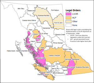
As of September 2008, legal orders intended to comprehensively implement SLUPs were in place for about half the province, and land use objectives had been established in 12 of the SLUP areas. In addition, specific legislation was enacted to implement plans for the Muskwa‐Kechika and Fort St. John areas[5] (Figure 1).
Land use objectives under the Land Act can also incorporate more detailed planning done subsequent to the completion of an SLUP. These plans can provide a comprehensive set of objectives reflecting the entire direction in the SLUP. Eight such plans covering 11 percent of the province have been completed. More commonly these plans are for single resource values (i.e., old growth management areas or wildlife management areas), and often only for portions of the SLUP area. Another key difference between these plans and SLUPs is that they are not based on a consensus model. The plans are developed by government staff, and key stakeholders are consulted as appropriate. These plans are mechanisms for implementing SLUPs. A table summarizing the status of SLUPs and lower level plans is provided in the on‐line version of this report.
The FRPA regime also enables the implementation of some SLUP objectives through objectives or measures enabled by the Government Actions Regulation of FRPA, which addresses issues about:
- resource features (such as karst caves)
- lakeshore management zones
- scenic areas and visual quality objectives
- community watersheds and water quality objectives
- wildlife habitat areas and wildlife habitat features
- ungulate winter ranges
- species at risk, regionally important wildlife and ungulate species
- fisheries sensitive watersheds and temperature sensitive streams
Figure 1. Legal status of SLUP
The extent to which these mechanisms have been used to implement objectives in SLUPs varies greatly and is, in part, a function of whether the related issues directly affect local residents and whether the mechanism was in place under the Code. For example, objectives for visual quality and community watersheds were well established under the Code and continue to be implemented in many places throughout the province under the FRPA regime. In contrast, objectives or measures for regionally important wildlife, or wildlife habitat features, have yet to be implemented anywhere.
The FRPA regime also contains provincial scale objectives, and practice requirements, under the Forest Planning and Practices Regulation (FPPR), the Range Planning and Practices Regulation and the Provincial Non‐Spatial Old Growth Order established under the Land Act. These objectives, and the associated practice requirements, may reflect objectives of a given SLUP. To the extent that this is the case, those SLUP objectives are legally enforceable.
Forest and range agreement holders must prepare plans (forest stewardship plans (FSPs) and range use or range stewardship plans, respectively) that specify results or strategies consistent with the objectives set by government.
In preparing FSPs, agreement holders may refer to SLUPs to clarify the “spirit and intent” of a legal objective (where an objective is vague or could be interpreted a number of ways—e.g., “maintain a mosaic of angling opportunities”), or to clarify specific terms used in a legal objectives (e.g., to more specifically define “thermal cover” and how it will be measured in the objective to “maintain at least 25 percent of the forested area in thermal cover”). Agreement holders may choose to incorporate alternative results or strategies in FSPs that reflect SLUP direction. For example, SLUP direction for pine marten could be incorporated into the results or strategies for FPPR 8 (riparian management areas) and FPPR 9.1 (stand level biodiversity), although the words “pine marten” would not appear in the FSP. If the direction is incorporated into the result or strategy for an objective, it becomes a legal commitment.
Results and/or strategies in FSPs that are tied to legal objectives are enforceable under FRPA. FSP content not tied to a legal objective is not legally enforceable.
Forest agreement holders must also prepare site plans to provide direction to operations. FRPA states that site plans must be consistent with the associated FSPs. The extent to which the SLUP direction is explicitly reflected in site plans will depend on the agreement holder’s commitment to the SLUP. SLUP direction that is out‐of‐date or unclear is unlikely to be used. Similarly, as agreement holders become less and less familiar with the SLUP, due to the passage of time and staff turnover, they are less likely to refer to it in site plans.
Non-Legal Implementation
A key element of the FRPA regime is the reduction in regulatory burden, compared to that of the Code. FRPA’s intent was to reduce cost and administrative complexity, while maintaining high environmental standards, public acceptance of forestry operations and continued timber supply. The FRPA regime is imbedded in a policy framework that places much of the onus for maintaining these things in what some refer to as “the non‐legal realm.” Because of the relatively recent implementation of FRPA, the effectiveness of the non‐legal realm remains uncertain. While only legal constraints can require the implementation of the social choices and societal expectations expressed in SLUPs, many agreement holders and government staff have commented that social licence was indeed a factor motivating consideration of SLUPs in stewardship decisions. In the context of implementing the aspects of SLUPs related to forest and range practices, there are a number of mechanisms that affect the accountability resulting from social licence.
Professionals responsible for forest and range practices could be held accountable by their professional organizations as governed by professional accountability acts.[6] For example, professional foresters are legally required to abide by the Code of Ethical and Professional Conduct of the Association of BC Forest Professionals (ABCFP) and could conceivably lose their right to practice if they don’t. The code of conduct states that a forester’s responsibility is to protect “the public interest by ensuring the multiple values society has assigned to BC’s forest are balanced and considered.” SLUPs provide one articulation of the values that have been assigned by society. If a forest or range professional is thought to have acted inappropriately, the principle mechanism for recourse is through a complaint to his or her professional association. However, it is forest and range agreement holders, not forest and range professionals, who are responsible for ensuring that activities on the land comply with the legal requirements of FRPA and the Land Act.
Plan implementation monitoring committees or other similar formal bodies (e.g., community resource boards) can promote accountability between the SLUP and its implementation. However, their effectiveness varies widely among SLUPs; these bodies are advisory in nature. In general, the most actively implemented SLUPs may be those that have a strong and committed public monitoring body in place.
Forestry agreement holders can enhance their social licence by obtaining certification that holds them accountable to independent standards[7] through third‐party audits with varying degrees of rigor. Certification typically requires agreement holders to consider both the legal and non‐legal context in which they operate (which would include SLUPs) but it does not require them to implement specific SLUP provisions. Sustainable forest management plans, created for the certification process, could implement SLUP direction. Agreement holders are not legally accountable for commitments made in a sustainable forest management plan. We also note that SLUPs can be used to guide the preparation and approval of forest stewardship plans (FSPs) in a number of non‐legally binding ways. For example, district policy based on SLUPs can be interpreted as standard practices, and those could be cited in FSPs. Standard practices[8] are assumed to represent a lower risks to the resource value, and require less supporting documentation than innovative practices.
Access Management Plans
LRMPs often led to the creation of Access Management Plans. As per its name, the general purpose of these plans is to help manage access to Crown land in the midst of multiple and often conflicting uses, such as resource development and back-country recreation. To manage access, each plan considers social, environmental, and economic values.
For example, the Vanderhoof Access Management Plan[9] aims to ensure industrial and public access while also addressing the affects of providing access for such uses. Key elements of the plan include the following:
- Managing road densities to maintain the integrity of recreational experiences for both motorised and non-motorised uses;
- Identifying a permanent road network for long-term access to various recreational opportunities; and
- Identifying specific recreation opportunities to provide certainty and reduce conflict between recreational users experiences and expectations.
Crown Land Plans
A Crown Land Plan is a sub-regional plan based on within settlement corridors. The purpose of a Crown Land Plan is to establish policy to guide the planning, management, and disposition of vacant Crown lands regarding residential, recreational, commercial, industrial, and institutional uses. Since the 1980s, only a few Crown Land Pans were created, perhaps only six. These include plans for each of the areas surrounding Fort St. James, Vanderhoof, and Prince George. A Crown Land Plan is primarily a map showing land designations accompanied by a legend and definitions of designations. Although Crown Land Plans exist, they are not referenced frequently.
The Fort St. James Crown Land Plan helps to illustrate the purpose and scope of these plans. Land use designations were based on “highest and best use” with consideration for the productive capability of the land (e.g., for agricultural use) and for the suitability of the land for specific uses. The capability of land accounted for such biophysical factors as climate, slope, landform, soils, and geology. The suitability of land considered present use, proximity, local agreements, and land use conflicts. The process to complete the plan was directed by a steering committee and informed by public consultations.
Crown Land Plans are connected with LRMPs in two ways. Crown Land Plans that existed prior to the creation of LRMPs were used to guide the development of the LRMP. In other cases, some LRMPs included an action item to create a Crown Land Plan.
Provincial policy: “New Direction” (2006)
In 2006, the Province of British Columbia shifted priorities for regional land use planning. This effort was branded as a “new direction” for Strategic Land Use Planning, as follows. The government’s priority to establish a “new relationship” with Indigenous peoples was a major thrust for this policy change. The text below is from the provincial document that set forth this new direction (pp. 8-13) (used with permission):
- Integrated Land Management Bureau (2006). A New Direction for Strategic Land Use Planning in BC: Synopsis. Victoria, BC: Ministry of Agriculture and Lands.
A New Direction for Strategic Land Use Planning in BC: Synopsis.
The following key questions have been addressed and a ‘New Direction’ for strategic land use planning formulated in response:
1. Completed plans: Do we need to update and monitor them and if so, what structures, mechanisms and priorities should we use?
Direction
1.1 Establish a strategic plan implementation monitoring committee (PIMC) for geographical regions or sub-regions of the Province, representing all the LRMPs and SRMPs completed in the geographical area. Include representation from key participants in the LRMP and SRMP processes, as well as Indigenous Nations. Develop a standard terms of reference for the PIMCs, clearly outlining their role and responsibilities, membership, and level of support.
1.2 Develop an action plan to migrate existing monitoring and implementation committees into these structures by March 31, 2007.
1.3 Restrict LRMPs and SRMP updating or amendment activities to specific components of a plan, as opposed to the entire plan. Require approval of updating or amendment requests by the inter-agency management committees (IAMCs). Develop standard procedures for Indigenous Nations engagement, and for consultation with the public and interested parties not represented on the PIMC.
1.4 Establish a list of priority circumstances that may warrant plan component updating or amendment. This list should include the need to align plan recommendations with policy and legislative changes, to reflect critical new information such as Indigenous Nations’ interests and values, and major environmental changes such as Mountain Pine Beetle infestation.
1.5 If a business case can be made for a comprehensive and thorough update of an LRMP to reflect new legislation, policy, information or environmental changes this should be done through the development of a specific plan or planning study for the topic or issue in question and forwarded to the ILMB Board of Directors for approval.
1.6 Support the updating or amendment of existing approved LRMPs and/or SRMPs affected by the Mountain Pine Beetle epidemic.
2. Legacy LRMPs: How do we expedite government decisions for the remaining LRMPs and complete the follow-up work required?
Direction
2.1 Conclude G2G discussions on all remaining legacy LRMPs (Morice, Sea to Sky, Lillooet and HG/QCI) by March 31, 2007 for Cabinet decisions and land use announcements.
2.2 Set a three year maximum time limit (end of fiscal 2009/2010) for completion of any follow-up work required for government decisions made for the Lillooet, Morice, HG/QCI, and Sea to Sky LRMPs, should completion work be necessary.
2.3 Require any further LRMP completion requirements (e.g., EBM, adaptive management, conservancy management, Indigenous Nations interim measures, community support) to become the responsibility of the relevant ministry after the end of fiscal 2009/10, following which ILMB will restrict its level of support to planning and implementation monitoring functions.
2.4 Legacy LRMP plan implementation monitoring structures will be integrated into the sub-regional implementation structure recommended in Part 1 above.
3. FRPA planning requirements: How do we honour our current commitments to complete legislated FRPA planning while addressing new planning pressures?
Direction
3.1 Undertake an assessment of the extent of planning required for the successful implementation of the current FRPA planning model. Develop an action plan that includes a schedule and list of priorities that will allow the completion of SRMPs for OGMA objectives in support of FRPA purposes by December 31, 2007.
3.2 Complete biodiversity planning by the end of fiscal 2007/08.
3.3 Continue the FRPA planning that relates to establishing legal objectives.
3.4 Wherever possible, create efficiencies by building planning for FRPA values into plans done in partnership with Indigenous Nations, the forest sector and other stakeholders.
3.5 Complete the development of legal objectives for EBM for application on the Central and North Coast and HG/QCI.
4. New strategic plans: Should we do new strategic plans and if so, what are the circumstances, priorities, processes and products?
Direction
4.1 Confirm the conclusion of the LRMP program and the initiation of new planning direction when announcing government land use decisions for the remaining legacy LRMPs.
4.2 Drop the LRMP and SRMP terminology and re-brand the strategic planning program (e.g., Strategic Land and Resource Plans).
4.3 Review strategic planning guidelines and procedure to ensure a focus on product requirements (e.g. FRPA, marine, land allocation) as opposed to hierarchical, geographical area-based plan requirements.
4.4 Initiate new strategic planning according to the following list of priorities and only in circumstances where:
-
- Planning is required to give legal effect to products of strategic plans through
FRPA, Land Act and other statutes. - Planning is required to address major emerging land use conflicts or competition among different user groups.
- Planning is required to identify economic opportunities and constraints associated with public land and resources.
- Planning is required to address Indigenous Nations’ opportunities, constraints, values and interests in areas where strategic plans have not been completed.
- Planning is required to give legal effect to products of strategic plans through
4.5 Require a “plan scoping” exercise be undertaken before formally proposing the initiation and funding of a new strategic plan.
4.6 Require ILMB Board of Directors’ endorsement prior to initiation of any new strategic plan, and based on recommendations of the “plan scoping” exercise.
4.7 All new strategic planning processes should adhere to the following principles:
-
- Led by government(s).
- Indigenous Nations’ involvement on a G2G basis where interested.
- Interest groups and stakeholders serve in a meaningful advisory capacity.
- Clearly defined process, timelines and products.
4.8 Product or outcomes of strategic plans should be:
-
- Clearly defined in a Terms of Reference.
- Facilitate operational planning.
- Minimize the need for supplementary “next-level” strategic planning.
- Tailored to address the specific issues that led to the initiation of the plan.
4.9 New strategic planning design, process and techniques should be structured on recommendations of the risk assessment for strategic planning.
4.10 New plans should be undertaken only when the beneficiary or implementing agencies are prepared to support the costs of implementation.
5. Indigenous Nations: What framework and processes do we use to address the New Relationship commitments to strategic land use planning with Indigenous Nations?
Direction
5.1 Develop a strategic planning Statement of Intent with the First Nations Leadership Council that provides overarching direction in accordance with key principles based on an assessment of existing, more detailed planning protocols.
5.2 Develop planning protocols with individual Indigenous Nations, where appropriate, based on the principles in the Statement of Intent developed with the Leadership Council.
5.3 Ensure that planning processes are jointly developed, address capacity, decision-making and conflict resolution, and are mutually acceptable. Strive to reach formal agreement with individual Indigenous Nations or where possible, aggregations of Indigenous Nations at the plan level on both planning processes and products, recognizing that agreements differ in each case.
5.4 Focus Indigenous Nations’ involvement in new planning and plan updating or amendment processes on incorporation of Indigenous Nations’ values and interests, and on land and resource management issues and outcomes that provide direction for these values and interests.
5.5 Ensure plan updating activities generated by PIMCs are done in collaboration with Indigenous Nations, where Indigenous Nations have responded positively to requests for engagement. Plan updating will be led by government in collaboration with Indigenous Nations and with advice from the appropriate implementation and monitoring committee.
5.6 Establish priorities for updating and amending existing plans based on:
-
- An assessment of risk to Indigenous’ values and interests, with highest risk areas being addressed first.
- Availability and cost of providing information on Indigenous’ values and interests.
- Indigenous Nations’ willingness to engage.
- Available agency resources.
- Level of IAMC support.
5.7 Pursue planning process outcomes with Indigenous Nations that will reduce and streamline subsequent consultation requirements for specific developments. Planning outcomes must improve resource management and development certainty for investors, the province and Indigenous Nations.
5.8 Support for Indigenous Nations’ requests for planning funds should be guided by the following:
-
- No support for the preparation of Indigenous Nations’ land use plans.
- Support for Indigenous Nations’ participation in joint provincial/Indigenous planning where the planning
exercise is a priority of government or has been committed to as part of G2G agreement. - Support for Indigenous Nations participation in joint provincial/Indigenous planning that is not a priority of government or committed to as part of a G2G agreement only if the Indigenous Nation can confirm that it does not have access to the New Relationship fund or other funding sources.
- Support where new funding sources are specifically allocated by government as part of special programs or initiatives e.g., Mountain Pine Beetle Action Plan.
5.9 Continue with FRPA planning, but provide for broader engagement on strategic issues with affected Indigenous Nations to support forest and range operations on public lands. On an interim basis, until Indigenous Nations’ values and interests are incorporated into existing plans, use FRPA and Land Act provisions to manage environmental values considered important to Indigenous Nations. Amend and revise legal resource management objectives after Indigenous Nations’ values and interests are incorporated into these plans.
5.10 Consider a regionally-based process, similar to the regime now in place for the Coast, such as a traditional territory or grouped Indigenous Nation territories, where the province works collaboratively with Indigenous Nations to confirm broad areas expressing level of opportunity versus constraint, or confirm areas with different value levels that warrant variable management regimes relative to resource development activity. For each of the above areas, a different level of Indigenous Nations’ involvement in subsequent activity can be negotiated, ranging from conservancy management agreements to refined and coordinated referral processes.
5.11 Ensure planning processes and G2G planning tables do not become surrogate forums for negotiation of rights and title, interim measures and other treaty-related issues, and for negotiation over individual land transaction issues.
6. Funding and staffing: How do we allocate resources to meet the new planning direction and the associated government priorities?
Direction
6.1 Establish a three year maximum time limit for the end of ILMB’s responsibility to fund completion work by other agencies and by Indigenous Nations (e.g. protected areas, conservancy management and planning) associated with Cabinet land use plan decisions. After this period, funding for agency completion work should be advanced by the appropriate agency as part of its own budget submission.
6.2 Ensure that plan mandate and plan decision documents clearly identify the anticipated fiscal implications of proposed negotiating mandates and final land use plan recommendations to Cabinet on agency operational costs.
6.3 Ensure agencies are made aware of the need to incorporate anticipated additional operational costs resulting from Cabinet land use decisions into their individual budget submissions to Treasury Board, particularly those costs that will be assumed from ILMB after the three year maximum time limit for ILMB funding of legacy plan completion work as noted in 6.1 above.
6.4 Establish a budget contingency to address unforeseen planning demands and unforeseen planning projects with Indigenous Nations.
6.5 Continue ILMB’s FRPA related planning and development of associated legal objectives only the basis of availability of FIA and CLUPE funding.
6.6 Maintain ILMB capability to represent the province in federal and local government planning processes where provincial interests and programs may be at risk, including maintenance of a marine and coastal planning program to support provincial involvement in federal oceans planning program, a marine protected areas initiative, and foreshore and marine resource allocation programs.
6.7 Assign resources to amend existing approved strategic plans affected by the Mountain Pine Beetle epidemic.
6.8 Provide sufficient resources for ongoing monitoring and amendment of OGMA/biodiversity plans.
6.9 Continue ILMB funding of implementation monitoring committees formed to provide oversight to ongoing plan implementation activities, as well as funding of new plans and plan revisions. Provide for a uniform level of funding for the operation of the new PIMCs and dedicate regional staff support to administer the PIMCs.
6.10 Provide sufficient resources to administer legal objectives and support ILMB/MAL’s role in FRPA implementation – in ILMB regions and in Crown Land Administration Division of MAL, and ILMB, Victoria.
6.11 Support the re-establishment of strategic planning staff in resource agencies to provide capacity for direct participation in strategic plan development, and in implementation of land use plans and decisions.
Provincial policy: “Modernising” regional land use planning
Currently, the Province of BC is pursuing a policy direction to “modernise” regional land use planning. Information about these current efforts is presented on the government’s website:
Province of British Columbia: Modernizing Land Use Planning.
As stated, the purpose of the current policy direction is as follows:
The B.C. government is modernizing land use planning in British Columbia to advance reconciliation efforts, support economic opportunities, and guide stewardship of provincial public land and resources that reflects the diverse values and interests of all British Columbians.
The drivers for this shift in policy centres are as follows:
- Reconciliation with Indigenous governments and the B.C. government’s commitment to implement UNDRIP.
- Ensuring communities and stakeholders are engaged in land and resource planning.
- A growing economy and increased demand on natural resources and the need to balance economic, environmental, social, and cultural objectives.
- Increasing complexity as a result of climate change and factors that affect the land base, including species-at-risk management, wildfires, flooding, and drought.
- Addressing cumulative effects on natural resource values.
By addressing the key drivers, the shift in policy aims to achieve the following (as stated on the website).
Reconciliation
Land use planning is carried out in partnership between the B.C. government and Indigenous governments. The values, traditions, knowledge, and cultural practices of Indigenous people are an integral component of planning processes.
Strong, sustainable economy
Land use planning improves dialogue between the B.C. government, Indigenous governments, and industry. It helps build relationships and identify solutions needed to advance economic opportunities for rural communities and create lasting economic benefits for all B.C. residents.
Resource stewardship
Land use planning helps manage our resources in a changing climate. Updated data and information from ongoing stewardship initiatives will support and inform planning processes.
In October, 2023, the Province announced a major shift in governance of natural resources as part of its effort modernise land use planning.[10] The aim was to bring responsibilities for natural resources under a single ministry; previously, responsibilities were divided among different ministries. In particular, responsibility for the following legislation, along with 24 additional legislative acts, were moved from the Ministry of Forests to the Ministry of Water, Land and Resource Stewardship:
- Water Sustainability Act
- Land Act
- Wildlife Act.
Resources: Modernising Land Use Planning
- Factsheets
- Resource Planning Partnerships Workshop (September 20-21, 2018):
- “What We Heard”: Indigenous Engagement Process on Modernized Land Use Planning in B.C. (September 2018 to March 2020):
- Memorandum of understanding between Union of British Columbia Municipalities and the Province
Media Attributions
- Figure 1. Legal status of SLUP © Forest Practices Board is licensed under a All Rights Reserved license
- Companies and people who hold licences under the Forest Act or Range Act. ↵
- Typically, watersheds of 10,000 to 100,000 hectares. ↵
- The Forest Practices Code of British Columbia Act contained the following: 41. Approval of plans by district manager or designated environment official. 41. (1) The district manager must approve an operational plan or amendment submitted under this Part if (a) the plan or amendment was prepared and submitted in accordance with this Act, the regulations and the standards, and (b) the district manager is satisfied that the plan or amendment will adequately manage and conserve the forest resources of the area to which it applies. ↵
- The Foresters Act, the Agrologists Act, the Engineers and Geoscientists Act, and the College of Applied Biology Act. ↵
- The Muskwa‐Kechika Act (1998) and Fort St. John Pilot Regulation of the Code, respectively. ↵
- See footnote 4. ↵
- There are three standards in common use in BC: Sustainable Forestry Initiative Standard (SFIS), Canadian Standards Association (CSA) and ISO 14001. A fourth standard, Forest Stewardship Council (FSC), is not commonly used in BC for forest stewardship. ISO 14001 is often used in conjunction with SFI or CSA, as it only defines the environmental management system. ↵
- “Standards of practice” are existing practices that have been informed by non‐legal guidance and believed to be the benchmark from which the degree of consistency with objectives can be determined. The designated decision maker can point to policy LRMPs as one source of results/strategies that speak to the “standards of practice” by value that also balance across values” (MFR Resource Tenures and Engineering Branch, Administrative Guide for Forest Stewardship Plans, Nov. 2006, p. 134). ↵
- Province of British Columbia, Vanderhoof Access Management Plan. ↵
- Province of British Columbia (Thursday, October 19, 2023). “Transfer of natural resource ministerial responsibilities: Information Bulletin.” Media release. ↵

Feedback/Errata