Application. Access to Rural Subdivision
RURAL PLANNING CASE STUDY
Assigned Task
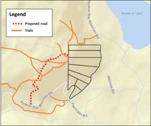
On July 14, 2008, the Integrated Land Management Bureau (ILMB)[1] received an application for a temporary permit to construct an access road to private land. The map submitted as part of the application indicates a road right of way starting from Hudson Bay Mountain Road and running approximately 1 kilometre northeast above Seymour Ridge (Map 1). Subsequently, the application was revised to avoid sensitive ecological areas (Map 2). The ILMB considered public comments prior to making its decision. On March 5, 2010, the ILMB issued its Decision Rationale on the proposed Seymour Ridge road. The Smithers Community Forest Society (SCFS) opposed the ILMB’s decision and submitted a Notice of Objection under s. 63 (1) of the Land Act[2]. The Minister decided that the objection warranted a hearing, as per s. 63 (2) of the Act.[3]
You have been hired as a planning consultant by the SCFS. Your task is to advise the group to develop the strongest position to present at the hearing. In your report to SCFS, present what you believe to be the strongest argument possible to oppose, and ideally overturn, the ILMB decision. Identify at least two main points of argument that you believe are essential to overturning the ILMB decision. Substantiate your position with references to legislation, land use plans, land use designations, and/or other relevant documents and decisions. [700-800 words]
Note: You are not being hired to identify an actual alternative route or its technical requirements.
Learning Module
Map 1. Seymour Ridge Access Road – initial proposal
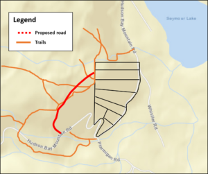
Purpose: Transportation/Roadway
Location: Hudson Bay Mountain Road, Smithers
Area: 1.0 hectare
BCGS Mapsheet: 93L075
Legal Description: Unreserved right of way over unsurveyed and in the vicinity of Hudson Bay Mountain, Range 5, Coast District, containing 1.0 hectares, more or less.
Map 2. Seymour Ridge Access Road – revised
INTEGRATED LAND MANAGEMENT BUREAU
Reason for Decision
Application by Elmore Contracting Ltd. for a Temporary Permit for Driveway Construction (ILMB File 6405671 – Reason for Decision)
Summary of decision
After weighing and assessing all of the public and agency referral comment as described above, I am satisfied that my determination to grant the land act tenure for driveway construction, with conditions attached, represents an appropriate and fair balance of the social, environmental and economic concerns expressed. I am also satisfied that my determination takes into account and fairly considers the balance of public values as expressed through the Bulkley LRMP and subsequent associated legal and policy documents.
SMITHERS COMMUNITY FOREST SOCIETY (SCFS)
Notice of Objection
Notice of Objection under Section 63 (1) of the Province of British Columbia Land Act – related to application for a temporary permit for a “driveway” (the “Seymour Ridge Road”)
Reasons/Grounds for Objection
Disposal of Application Not Complete
1. Although the status of this application is posted as “offered” on the ILMB Website, the disposition is not yet complete due to the requirement that an Occupant Licence to Cut be issued by the District Manager, Ministry of Forests and Range, Smithers. See s. 8(3) and s. 8(4) of the Land Act (the “Act”). The Licence to Cut has not yet been issued.
2. The Reason for Decision posted on the ILMB web site states that an offer has been made subject to any terms and conditions that need to be met before the tenure is issued. There is no indication that any or all of these terms and conditions have yet been met.
3. In the Decision Rationale posted on the ILMB web site, the application is described as a Temporary Permit, suggesting a permit under s.14(1)(c) of the Act, yet the ILMB decision maker states that the decision is being made under s.11 of the Act. The application cannot be considered complete for the purposes of s. 63(1) until the decision-maker unequivocally informs the applicant and the public under which provision of the Act she is exercising her jurisdiction.
Substantive Objections
4. The “driveway” is being proposed through a Core Ecosystem of the Bulkley Land and Resource Management Plan (LRMP) and the Bulkley Valley Sustainable Resource Management Plan (BVSRMP) – the purpose of which is to provide a representative cross-section of naturally occurring ecosystems, to maintain biodiversity by providing interior forest conditions, and to maintain biodiversity by retaining representative examples of rare and endangered plant communities in core ecosystems. Specifically, the strategies in the BVSRMP state that within core ecosystems, if harvesting does occur, no permanent road access structures can be built. Although the decision maker states in her rationale that the driveway is not a “management activity” and thus it should not be specifically excluded, this is a technicality that completely ignores and contravenes the meaning and intent of the Core Ecosystem designation resulting from a long established and extensive public planning process. Though referred to as a “driveway” in the application, the rationale states that public access will not be restricted. The term “driveway” is commonly used to describe a private access way falling completely on private land. What is actually being approved in this case is a “road” that will provide public vehicle access into a significant portion of the Core Ecosystem – a Core Ecosystem which has already been impacted elsewhere by road access.
Improper Consideration of Slope Stability
5. In the consideration of this application by the decision maker, considerable weight is given to slope stability concerns where a public road, Hudson Bay Mountain Road, is adjacent to the lots for which access is sought, yet the decision-maker provides no references to any technical or professional reports to substantiate any slope stability concerns along that existing road which allegedly prevent the applicant from accessing his property from there. As well, there is no reference to any technical reports to substantiate the overriding assumption that the Seymour Ridge road access provides any less slope stability risk than the Hudson Bay Mountain Road access. So far, our attempts to obtain any relevant reports that were used in the decision have failed.
6. Further, the decision-maker does not appear to have considered any slope-stability and other access matters raised by the approving officer under s. 73 of the Land Title Act when the lots that the “driveway” purports to access were originally subdivided. Under the Land Title Act, land cannot be sub-divided until, among other things, the sub-divider can provide each lot with legal access to a public road. In the present application, the decision-maker should have considered why that originally approved access is now said to be unavailable.
Insufficient Consideration Given to Public and Agency Advice
7. The decision maker states in her decision rationale that the three previous applications for a similar road were turned down largely on the advice of the Smithers Community Forest Steering Committee (now called the Smithers Community Forest Society). This committee is designated in the Bulkley LRMP as the body that coordinates management activities within the Smithers Community Forest – where this and the previous applications occur. For the past 22 years, this body has been actively involved in the coordination of recreation, forest management, and ecosystem interpretation initiatives in the Smithers Community Forest. The decision maker goes on to state that since the Wetzin’kwa Community Forest tenure was awarded for this same area in 2007, the role of the Smithers Community Forest Committee (now the Society) has largely been taken over by the Wetzin’kwa Community Forest Corporation (WCFC). This is incorrect in that the current Memorandum of Understanding between the Society and the WCFC clearly outlines the significant role the Society continues to play in management recommendations within the Recreation Emphasis Zone where the proposed road is located. Had the decision maker properly understood this relationship between these two bodies, she would have been obliged to give greater weight to the recommendations against approval of the application put forth by the Smithers Community Forest Society. The rationale states that the WCFC supported the application. At a recent public meeting, however, the Manager of the WCFC emphasized that their position on the road was neutral – neither for nor against.
8. The Ministry of Environment (MoE) submitted referral responses for this and previous applications for roads on Seymour Ridge that strongly recommended against approval – due to environmental sensitivity, risks to wildlife habitat values, and incompatibility with the management direction provided by the LRMP. In fact they recommended that s.17 (Conditional Withdrawal) of the Land Act be explored for the area in order to reflect the LRMP management/planning direction. The decision maker in her rationale describes the advice of MoE in some detail but in the end this advice appears to have little bearing on her decision. If there is disagreement between these two government agencies on the merits of this application/approval, then an internal mechanism to resolve this dispute must be implemented.
9. The Bulkley Valley Community Resources Board (CRB), the body responsible for overseeing the implementation of the Bulkley LRMP, also submitted a referral letter recommending against approval of this road through the Core Ecosystem. There is no mention of this significant and very relevant referral advice in the rationale of the decision maker, and thus no indication that this advice was even considered by the decision maker.
The Smithers Community Forest Society thus objects to Application 6405671 and the process by which it is being considered for approval by the ILMB decision maker. We request a formal hearing and an independent review of the decision and the rationale for this application.
Public Comments Posted on ValleyVision website
Comment #1
“As there is already good road access to this property from H.Bay Mt. road, there is no reasonable need for a second access. My second reason is that crown land with historic use by recreational hikers and bikers should not be compromised for a private road that is not needed by the applicant.”
Comment #2
“Something that the public may not be aware of is that the covenanted area, shown in green on the map, is proposed by the road applicant. This was to address public concern relating to endangered grassland. (Most of which is on private property.) Concerning the ‘already good access to this property,’ it is impossible to build a road to the top, which is the only usable area, from the bottom of the property due to slope instability and grade.”
Comment #3
“I feel the impact on the trail and those who use it will be negative. Crown lands should not be compromised for use of the private individual.”
Comment #4
“What about the fact that a driveway would actually open up opportunities for those people that are not able to access the view and unique features now? (Which by the way, is on our PRIVATE property as are some of the trails.) (Physically challenged, daycare groups, the elderly, etc.) Plus, our covenant on the red-listed grassland ecosystem on our private property should be worth something as far as ‘compromising’ Crown land. People should research what is really going on here and not just blindly trust those who supposedly know, yet are not letting all the facts be known.
Media Attributions
- Map 1. Seymour Ridge Access Road – initial proposal
- Map 2. Seymour Ridge Access Road – revised
- Now the Ministry of Water, Land and Resource Stewardship. Also formerly the Ministry of Forests, Lands, Natural Resource Operations & Rural Development. ↵
- Note that the Land Act has changed since the time of the application. Sections 14 (Temporary occupation of Crown land), 63 (Disputed applications), and 64 (Appeals of disputed applications) were repealed in 2015 (s.14 repealed by 2015-26-33; ss.63 and 64 repealed by 2015-26-40; effective September 22, 2015 by BC Reg 174/2015). These avenues to object or appeal a decision to dispose of Crown land are no longer available. To learn more about options for legal recourse, see the Learning Module. ↵
- The proposed road and Notice of Objection are real events. However, there was no appeal. ↵

Feedback/Errata