Plate Tectonics & Earth’s Interior
Learn about what Earth is like on the inside and how we know, how plate tectonics works, and how plate tectonics has shaped our planet.
If you’re interested in how plate tectonics shapes landscapes, you might also like this video:
 |
How Was the Grand Canyon Formed? Learn about how plate tectonics and river processes worked together to create this natural wonder. Go! |
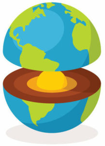
How Do We Know About the Earth’s Core?
A video from the Khan Academy. The resources accompanying this video were created by James McIntosh and are shared with a CC BY-NC license.
Summary
This video uses a diagram to represent the movement of seismic waves through the Earth, it describes how different waves—P-waves and S-waves—behave in the primary states of matter: liquids, solids and gases, and how the properties of these waves allow us to determine the composition of the Earth based on measurements made around the world. It stands out due to how intuitive the concept becomes to the viewer without the need for mathematics, while still being brief.
Why Watch This Video?
- Have you ever wondered how scientists using earthquake data to prove the origin of Earth’s magnetic field?
- Would you like to know how vibrations produced by earthquakes can be measured?
- Have you ever wondered how we know where one layer of the Earth starts and another ends?
Key Terms
P-wave. Primary wave, it is the fastest kind of seismic wave and can travel through the three principle forms of matter, solid, liquid, and gas. P-waves push and pull on an object in the direction (or opposite direction) of the wave propagation.
S-wave. Secondary wave, these can only move through solid rock and are responsible for the feeling of an earthquake. S-waves move an object perpendicular to the direction of wave propagation and occur slower than P-waves.
Refraction. The change in angle for the trajectory of an object due to changes in density of the material(s) that object is traveling through.
Loose Ends
Why might different waves be able to travel through different phases of matter?
In P- and S-waves, the direction of particle motion is different, in P-waves particle motion is in the same (or opposite) direction as the wave motion so any matter can be affected. While in S-waves the direction of particle motion is perpendicular to the motion of the wave, so liquids and gases, which aren’t rigidly bonded together like in solids, do not propagate s-waves, since particles can slide past each other instead of moving as a whole.
Why/How do P-waves move slower in liquids?
The phase velocity of a wave changes with the medium. In liquids particles are more free to move, this means that collisions in the liquid are not as frequent as within the solid and so the wave is slower. This is like dominoes (of the same size) falling, the more space between the dominoes, the more time it will take for them all to fall. If enough space exists between them, it cannot knock over the next one and the wave doesn’t propagate at all.
Molten areas within the Earth will slow P-waves and stop S-waves because shearing motion cannot be transmitted through a liquid.
Caution: In the video Sal Kahn says S-wave shadow zone, while the image refers to the P-wave shadow zone.
There are distinct shadow zones created by the waves, the P-wave zone is illustrated and is due to P-waves being refracted upon entering the liquid medium for those who reach the depth of the liquid core. Sal Kahn is referring to the S-wave shadow zone which would be between 105˚ CW to 105˚ CCW measured from the top of the figure due to the absence of S-waves in this region.
Self-Test
Try these questions to test your understanding.
Plate Tectonics Explained
A video by MinuteEarth. The resources accompanying this video were created by Dahyun Son and are shared with a CC BY-NC-SA license.
Summary
This video gives an overview of what Plate Tectonics is and how it works. In the video, it explains that the currents in the upper mantle are one of the common explanations for why tectonic plates are moving. Moreover, focusing on the convergent boundary, it also clarifies the subduction into the mantle and slab pull as the reason why the tectonic plates sometimes move faster than the current in the mantle.
Why Watch This Video?
- Have you ever wondered how today’s 7 continents were formed?
- Would you like to know how tectonic plates are moving?
- Have you ever been confused by the fact that tectonic plates all move at different speeds?
Key Terms
Converging current (or convergent plate boundary) means that the plates move toward and collide with each other.
Diverging current (or divergent plate boundary) means that the plates move apart from each other.
The subduction zone is a region where the denser plate of the ocean crust slides or sinks into the mantle, under the other plate.
Loose Ends
Why are the continents like “baggage” and is the seafloor(ocean) crust like “part of the conveyor belt?” Are they different? Which one is considered a plate?
In fact, both continents and ocean crusts are the components of the plate (Panchuk, 2020). That is, the plate is a superordinate concept of them. Lithospheric plates can be divided into continental crust and ocean crust (Panchuk, 2020). Some plates consist of only continental crust, while the others consist of both continental and ocean crust (“What is a Plate?,” n.d.). Therefore, you should remember it is the entire lithospheric plates that are currently moving, not just continents or ocean crust. For these reasons, we can say that the continents that are on the Earth’s surface are more like “baggage”, and the underwater ocean crust is like “part of the conveyor belt” (Plate Tectonics Explained, 2015).
Is the current in the upper mantle the only explanation for why tectonic plates are moving? Are there any other explanations?
There are three main explanations (or driving forces) of how plates are moving. The first one is mantle convection, which is mentioned in the video, and the second one is slab pull, also is explained in the video. The last one is ridge push. Ridge push is can be seen on the divergent boundary (Panchuk, 2019). When on the divergent boundary, lithospheric plates are pulled apart at mid-ocean ridges due to the newly raised lithosphere and push on older, and farther lithosphere from the ridges (“Ridge push,” 2020)
How are the plates pulling themselves?
There also is convection for plates (Gardiner, 2008). Just like fluids, as the temperature increases, the density of a fluid decreases and goes up. In contrast, when the temperature is low, the fluid becomes heavy and therefore, falls down the floor (“Convective Heat Transfer,” 2020). Plates also have warmer and thinner parts that are more likely to rise, and colder, denser parts that are more likely to sink, pulling the rest of the plate down into Earth’s interior (Gardiner, 2008).
Self-Test
Try these questions to test your understanding.
References
-Wikipedia-
Convective Heat Transfer. (2020, September 22). In Wikipedia.
Density. (2020, October 19). In Wikipedia.
Ridge push. (2020, November 10). In Wikipedia.
-Online Contents-
Gardiner, L. (Ed.). (2008, May 21). How Do Plates Move?
The Geological Society. (n.d.) What is a Plate? The Geological Society.
-Online Books-
Panchuk, K. M. (2019). Plate Tectonics. Physical Geology, 1st USask Edition.
Panchuk, K. M. (2020, January 8). Overview of Plate Tectonics. Laboratory Manual for Earth Science, 1st UBCO Edition.
-Videos-
MinuteEarth. (2015, January 15). Plate Tectonics Explained [Video]. YouTube.
How Do We Know Plate Tectonics Is Real?
A video by It’s Okay To Be Smart. The resources accompanying this video were created by IKuo and are shared with a CC BY-NC-SA license.
Summary
Plate tectonics were originally discovered by Alfred Wegener who noticed the continents fit together. He also noticed that there were the same fossils and types of rocks on different continents. Later, this concept of plate tectonics and continental drift was further supported due to the discovery of magnetic fields. It was discovered that plate tectonics have always been in motion due to thermal convection and continue spreading apart as we speak.
Why Watch This Video?
- Have you ever wondered how continental drift was discovered?
- Would you like to know how we know Earth’s geological history?
- Have you ever been confused by how tectonic plates move?
Key Terms
Continental drift. The idea that the continents move and are now located at different positions than they used to be. It was believed that they used to be one big continent called Pangea, and through continental drift, they have separated and moved to different parts of the world, forming different continents.
Thermal convection. A form of heat transfer where the heat is transferred by materials rising. One material is less dense and higher in temperature and transfers its heat. In the asthenosphere thermal convection keeps the asthenosphere malleable and aids in moving the lithosphere which is how tectonic plates move.
Rift valleys typically form when tectonic plates split apart, resulting in a region of land that sinks below and is lower than the rest of the land around it. They can also happen at the bottom of the ocean when the ocean floor spreads. Another way for rift valleys to form is when tectonic plates move past each other and grind, also called transform faults.
Loose Ends
How do continents move?
There are many layers to Earth, it is not one solid piece that moves around when we discuss tectonic plates. Tectonic plates are made up of the lithosphere, crust, and uppermost part of the mantle. Tectonic plates float on top of the asthenosphere which is a weak region under the lithosphere. The asthenosphere is malleable from thermal convection and moves the lithosphere, resulting in continents moving. The convection currents drive the movement of tectonic plates. Tectonic plates have different boundaries. They can converge, diverge, or move past each other and are named convergent, divergent, and transform boundaries respectively.
Magnetic field flipping throughout the planet’s history.
Magnetic minerals found in rocks once cooled, aids in displaying the Earth’s magnetic field history. The magnetic field is estimated to reverse every 200,000 years, but our current field has not flipped for around 780,000 years. The magnetic field of Earth is important because it has played a big role in providing evidence of tectonic plates. The magma containing magnetic materials emerged from oceanic ridges. Once the magma hardens, the magnetic material that was aligned and oriented to the fields is also preserved. Many of these rocks found were not oriented towards the right pole and alternating poles of magnetic material pointing south and then north and south were discovered. This is also called magnetic striping. The discovery of this resulted in the conclusion that the tectonic plates were pushed apart as magma rose out of the ridges. The magnetic field of the rocks had different orientations because the continents moved and shifted. This overall discovery of magnetic fields preserved in rocks created the evidence needed to support tectonic plates.
What is the Ring of Fire?
The Ring of Fire is a belt found along the Pacific Ocean where many active volcanoes and earthquakes are found. 75% of volcanoes and 90% of earthquakes happen on this Circum-Pacific Belt. This is because this is a very active subduction zone where tectonic plates are constantly converging. The section between Pacific and North American Plates, however, has transform boundaries where the plates move past each other and is where a lot of the earthquakes happen due to the tension built up in the crust of the Earth.
Self-Test
Try these questions to test your understanding.
How North America Got Its Shape
TED-Ed lesson by Peter J. Haproff. The resources accompanying this video were created by Abigail M. Villard and are shared with a CC BY-SA license.
Summary
The Earth’s land structures are constantly moving and changing by way of plate tectonics; it is the interactions between these plates that have shaped the landmass of North America through converging, diverging, and transformation boundaries. This video reviews the formation of North America’s geological features beginning with the rifting of an ancient supercontinent, Rodinia, and the formation of the most recent one, Pangea, concluding with the formation of present-day Earth. The process of Pangea’s formation and the current boundary processes, caused by plate movement after rifting, are the processes that create North America’s mountains, volcanoes, basin and range, canyons, and other prevalent features.
Why Watch This Video?
- Have you ever wondered why the San Andreas fault is such a hot spot for natural disasters like earthquakes?
- Would you like to know how some of the most stunning natural attractions across North America were created by the movement of Earth’s crust?
- Have you ever been confused as to how North America ended up as its own landmass separate from the rest?
Key Terms
Tectonic plates are large fragments of Earth’s ridged outer crust, called the lithosphere, floating on top of the weaker asthenosphere. This allows for their movement and interactions at plate boundaries. It is the interactions between these massive plates that are in constant motion that create many prevalent geological features and cause natural disasters.
Supercontinents are large land masses consisting of all the Earth’s continental crust joined. There have been multiple past supercontinents throughout geological time as the Earth cycles through stages of supercontinent formation and then rifting including Rodinia, and most recently Pangea. This process, driven by the heat convection gradient of the Earth’s mantle and gravitational forces acting on tectonic plates, is known as the Wilson cycle.
Geological time (also known as deep time) is a concept used to describe processes that move at an extremely slow rate and therefore take thousands to billions of years to occur. Many of these processes are still ongoing to this day where tiny changes occurring over a large period of time will result in a dramatically different outcome from before the process began. Geological time covers the whole timeframe that Earth has existed, approximately 4.57 billion years. The processes detailed in this video took millions of years to complete; Earth is very old!
Loose Ends
How do tectonic plates move?
Tectonic plate movement is caused by Earth’s convection system that supplies the energy for movement through the Earth’s internal heat and the force of gravity. One model of the mechanisms for plate motion looks at ridge push and slab pull forces causing movement at plate boundaries. Slab pull, the primary force for plate motion is caused by the gravity force acting on the colder denser portion of the plate subducting that drags the rest of the plate in the direction of its motion. Ridge push describes a plates tendency to fall away from elevated ridges due to gravity effectively pushing the entire plate in the direction of that force. It is these forces and heat energy that causes the plates to move in the ways described in the video.
What are transform boundaries?
The San Andreas fault is a prime example of a transform plate tectonic boundary. Plate interactions of this nature are characterized by the sliding movement of crust relative to each other, no new crust is formed, and no old crust is being subducted. The motion of these plates is inconsistent, locking causes shear stress on the surrounding rock, and the release and movement of the plates cause the many shallow earthquakes characteristic at this boundary. Transform zones are often found between areas of subduction and areas of divergence as plates are in motion being dragged and pushed past each other.
What is faulting and folding?
Faulting and folding of Earth’s crust on a large scale can create mountains. Faults and folds are terms that describe the deformation of a rock when plate collisions apply a force called stress to the Earth’s crust. Folds are common to convergent boundaries where the plates are compressed together, deforming the rocks without breaking them. Deformation is defined as faulting when the rocks move from their position relative to each other on either side of a crack. The type of deformation that occurs depends on the rock’s composition, the heat, and pressure, as well as how the stress is applied. For example, the ancient continent-continent convergent boundary between Laurentia and the African plate applied extreme compressive forces on the crust causing the creation of the Appalachian Mountains. This mountain range is an example of a folded mountain created by large scale faulting and folding.
 Caution: Is the mantle really magma-filled?
The video describes subduction as a process that “diffuses water into the magma-filled mantle.” In fact, the mantle is mostly solid, with relatively tiny amounts of magma that form where conditions are just right. Subduction zones are one place where those ideal conditions exist, thanks to the water present.
Self-Test
Try these questions to test your understanding.
References
Burke Museum. (n.d.). Dance of the Giant Continents: Washington’s Earliest History.
Haproff, P.J, (2016, July 5). How North America got its shape- Peter J. Haproff [Video file].
Panchuk, K. M. (2019). Earth’s Interior. Physical Geology, 1st USask Edition. https://openpress.usask.ca/physicalgeology/
Panchuk, K. M. (2019). Geological Structures & Mountain Building. Physical Geology, 1st USask Edition. https://openpress.usask.ca/physicalgeology/
Panchuk, K. M. (2019). Plate Tectonics. Physical Geology, 1st USask Edition. https://openpress.usask.ca/physicalgeology/
Prentice, C., Scharer, K., Wald, L., (2017, June 1). Back to the Future on the San Andreas Fault. USGS science for a changing world.
Rockies Thrust Up
A National Geographic video. The resources accompanying this video were created by RK and are shared with a CC BY license.
Summary
“Rockies Thrust Up” by National Geographic investigates the origin of one of the largest mountain chains on Earth. Geologists dive into the interaction between the North American plate and the subducting Pacific plate, and how over millions of years their collision pushed the Rocky Mountains up and into existence. Furthermore, visual examples are presented to demonstrate the movement and behaviour of rock under different pressures, and how these activities can explain the geological structures present today.
Why Watch This Video?
- Have you ever wondered what kind of rocks make up mountains like the Rockies?
- Would you like to know the age of some of the world’s most well-known geological structures?
- Have you ever been confused by the behaviour and results of collisions between oceanic and continental plates?
Key Terms
Subduction is a part of the collision process between either an oceanic plate and a continental plate, or between two oceanic plates. When the two plates collide, the denser oceanic plate will be forced down, or subducted, into Earth’s interior.
Tectonic plates are pieces made up of the lithosphere, which includes Earth’s crust and the top layer of the mantle, which together form the Earth’s surface. These plates are in constant motion and can interact by colliding, separating, and gliding past each other.
Sedimentary rocks are created when tiny pieces of other rocks, called fragments, are buried, compressed, and fused together.
Loose Ends
Why do mountains usually form close to plate boundaries?
National Geographic states that in the past many were puzzled as to how the Rockies formed so far from any plate boundary. They fail however to expand on the topic, leaving the audience wondering “Why do mountains usually form close to plate boundaries?”
Non-volcanic mountain ranges, such as the Rockies, form when two continental plates collide. As the crust in the collision zone undergoes the most stress and compression, it is expected that this area is where the folding and warping of rocks will be dramatic enough to form mountains. In other terms, one would think that the location where the Rockies stand today was simply too far away from the action. This is why scientists had a hard time understanding how the Rockies formed where they did.
How do geologists know the age of a rock?
National Geographic provides no proof to support their statement that the granite making up the Rockies is in fact 1.7 billion years old. How do they know this is true?
A common technique used to determine the approximate age of rocks is related to geochronology- the study of dating geological events and processes. Geochronologists use the principle that uranium decays and turns to lead at a know exponential rate. By studying the proportions of uranium and lead in certain minerals in metamorphic rocks, they can estimate the rock’s age.
Where and what are the North American and Pacific plates?
Throughout the video, the North American and Pacific plates are brought up time and time again. Despite their relevance, the plates themselves are never clearly explained, nor are the locations of their boundaries presented.
The North American and Pacific plates are relatively large segments of lithosphere, that move approximately per year. The Pacific plate underlies the majority of the Pacific Ocean, and stops at the west coast of the North American continent. The North American plate underlies the entire continent of North American, including Greenland, and carries out into the North Atlantic Ocean.
Self-Test
Try these questions to test your understanding.
References
Wood, Eleni. (2018). How old is a mountain range?
