Application. Urban Fringe
URBAN PLANNING CASE STUDY
Assigned task
Presently, Official Community Plans (OCPs) of the Regional District of Fraser-Fort George (RDFFG) are outdated. Several were adopted in the 1990s; the most recent OCP was adopted in 2010. Although all the OCPs have been amended over the years, none has been reviewed comprehensively to reflect current conditions or align with the long-term sustainability plan (myPG) and with the City of Prince George’s OCP (adopted in 2011).
This situation presents both challenges and opportunities. On the challenge side, one may ask whether the Regional District’s dated OCPs provide sufficient direction to guide land use decisions. Without adequate direction, the RDFFG is at risk of making land use decisions on a parcel-by-parcel basis that could undermine more than fifty years of planning efforts to gain control over the historical pattern of “rural sprawl” that occurred during the boom years of the 1960s and 1970s. On the other hand, this situation presents the RDFFG with an opportunity to update their legislative framework for land use planning, especially to address future development in the urban fringe.
As an expert in urban planning, you are to advise an ad hoc advisory committee established by the RDFFG about how to improve the legislative framework for land use planning (OCPs, zoning bylaws). The ad hoc committee includes representatives of the RDDFG Board of Directors and the senior members of planning staff. This committee will present their recommendations to the RDFFG Board of Directors for further discussion and action.
Your task is to advise the committee regarding the relative strengths of each of the following options and provide evidence of any critical deficiencies:
- Status quo. Maintain the current OCPs and zoning by-laws for the areas surrounding the City of Prince George. Provide evidence to support this option. For example, demonstrate that the current Salmon River-Lakes OCP and zoning by-law provide adequate to the Board for addressing the proposed re-zoning.
- Update current OCPs and zoning by-laws. Consider a full or partial review of all RDFFG OCPs and zoning by-laws that surround the City of Prince George.
- Create fringe area OCP and zoning by-law. Create a single OCP and zoning by-law that covers the area immediately surrounding all of the City of Prince George. For example, this OCP and zoning could be similar to the fringe area OCPs in the Cariboo Regional District that surround the City of Quesnel and the City of Williams Lake.
- Create a Regional Growth Strategy (RGS). The Local Government Act (Part 13) enables a regional district to adopt a RGS for all or, with permission, part of a regional district.
Based on your assessment of these options, present a recommendation with rationale. Clearly state the most important reason(s) for why your recommendation is superior. Include any essential supporting details to be clear about what is to be done for what area(s). If you recommend more than one option then clearly state the order the options should be completed.
Length: Maximum 1,000 words.
In its simplest terms, “urban fringe” refers to the ring that surrounds a city’s boundary and has a mix of rural and urban characteristics. The mix of characteristics depends on the location, such as the landscape (agricultural or forested) and proximity to other urban areas.
Uncontrolled development in the fringe areas of the City of Prince George has always been a challenge. Past efforts to better control growth in the urban fringe included adopting an Official Regional Plan (1972) to develop satellite towns in areas under the jurisdiction of the Regional District and extending the City’s municipal boundaries on multiple occasions, including the most significant boundary extension in 1974. These boundary expansions served to capture the closest elements of the existing urban fringe; inevitably, the corresponding effect was to establish a new fringe area further from the City’s core. Without surprise, managing the urban fringe area of Prince George remains a challenge.
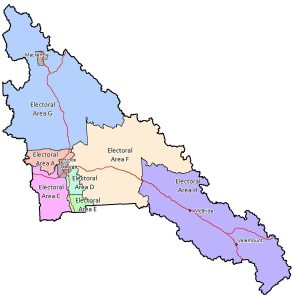
Today, the urban fringe of Prince George has a mix of agriculture, forest, river valleys, and low-density rural residential, with no influence from other urban centres. Of note, many areas within City limits also have rural characteristics. Although these areas of the City have some urban amenities, parcels are often at least 0.81 hectares (2 acres) and do not have water or sewer services. Consequently, there is often little distinction between rural areas within City limits and the adjacent fringe. For our purposes, the defining feature of the Prince George urban fringe is jurisdiction; we define the urban fringe as the ring area under the jurisdiction of the Regional District and adjacent to City boundaries. For RDFFG, the urban fringe is covered by five OCPs, each aligned with different Electoral Areas (Figure 1).
According to the City’s OCP and myPG Sustainability Plan, none of the City’s rural areas are designated as growth nodes. By focusing on these nodes, and under expected low rates of growth, the City has ample designated space within its borders to support higher-density residential development and urban amenities, without concern for running out of space. In contrast, RDFFG has a strong desire to increase its revenues from property taxes by encouraging development of the urban fringe land base. Likewise, developing land in the urban fringe is an attractive option for land owners who desire living closer to nature while maintaining access to the City’s amenities.
This planning context in the urban fringe is common, and local governments have found different ways to manage conflicting interests between regional districts and its member municipalities. These solutions, each oriented to specific conditions, include OCPs (usually based on an Electoral Area or part thereof), urban fringe plans (e.g., Quesnel, Williams Lake), and Regional Growth Strategies. Given the need to update its suite of OCPs, RDFFG has an opportunity to consider how best to manage development in the urban fringe area.
Figure 1. Electoral Areas, Regional District of Fraser-Fort George, BC
An example of parcel-specific land use planning
A recent decision by the RDFFG Board to rezone a parcel illustrates the challenges of making land use decisions in the urban fringe (File No.: REZ 5676/23447/1). This example encompasses different perspectives that reflect a range of current land use planning challenges. This zoning amendment is worth considering in a broad context. For the subject property, there are important questions about whether the location is appropriate for higher-density residential development. To answer this question, consider (a) the suitability of the subject property; and (b) the suitability of the area to accommodate higher-density residential development. As an expert in urban land use planning, you are encouraged to consider all perspectives to gain insights about these challenges inform your recommendation to the RDFFG for updating their planning documents.
Note: you are not being asked whether you agree or disagree with this specific decision to rezone the subject property; this example is for illustrative purposes only to provide context for the kind of parcel-by-parcel decisions that RDFFG has and will continue to address. Many of the specific issues about increased residential subdivision for the subject property are not restricted to the Pilot Mountain area and have broader implications for providing sufficient direction for land use decisions for the whole fringe area of Prince George.
Summary of application
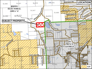
In 2020, a private developer submitted an Application for Development to the Regional District of Fraser-Fort George (RDFFG) to rezone a 32.5 hectare (80 acres) property to facilitate subdivision into rural residential lots. The subject property is located in the Pilot Mountain area, directly west of the City of Prince George municipal boundary (Figure 1). The legal description of the property is North half of North East Quarter of District Lot 2415 Cariboo District (N1/2 of NE1/4 DL2415 Cariboo District).
The subject property is covered by the Salmon River-Lakes OCP, which designates this area for residential development under Rural Residential, which states under s. 3.3.6: “Within the Rural Residential designation the density for creation of new parcels is based on a minimum parcel size of 1.6 ha (4 acres)…”. The parcel is zoned Rural 1 (Ru1) under the Zoning By-law No. 2892, which requires a more restrictive minimum parcel size of 15 hectares (37 acres).
As per the Application for Development to rezone the subject property, the purpose of the zoning amendment (By-law No. 3195, 2020) was to allow for increased residential subdivision of the subject parcel, as follows.
Current zoning: Rural 1 (Ru1)
Minimum parcel size: 15 hectares
Proposed zoning: Rural Residential 2 (RR2)
Minimum parcel size: 1.6 hectares
The subject property is located within an ecologically-sensitive area adjacent to the Ferguson Lake Nature Reserve, a public recreational space that was established in 1990 to protect forest, riparian, and wetland habitat. The Nature Reserve, located entirely within the City of Prince George, is protected by a Riparian Protection Development Permit area designation (Schedule D-2: Riparian Protection Development Permit Areas), as per the City’s OCP (No. 8383, 2011). As well, the RDFFG OCP requires 300-metre buffers arounds lakes to protect water quality (Lakeshore Development Permit Areas).
Figure 1. Location of subject property (N1/2 of NE1/4 DL2415 Cariboo District)
Within the four years of the current Application for Development being submitted, the subject property was clear cut. Insufficient regard was given for the riparian areas of two streams that drain the property into Ferguson Lake. Also, a significant portion of the land within the Lakeshore Development Permit Area was cleared without permission.
The following documents provide additional details.
- Application for Development (prepared and submitted by applicant, Aug. 6, 2020)
- Applicant’s original conceptual design for proposed subdivision, p. 12.
- Staff report: Report for Consideration;
- Public Hearing, April 8, 2021, Minutes (unapproved)
- City of Prince George submission, pp. 8-9.
- Letters from members of public, pp. 10-59
- Applicant’s revised conceptual design for proposed subdivision (Aug. 4, 2021)
Arguments for and against
The rezoning application was subject to a public hearing. Prior to the hearing, members of the public submitted 32 letters opposing the rezoning. After hearing concerns raised by members of the public, the initial public hearing was adjourned to give the applicant time to respond to the concerns.
This zoning amendment is worth considering in a broader context. For the subject property, there are important questions about whether the location is appropriate for higher-density residential development. To answer this question, consider (a) the suitability of the subject property; and (b) the suitability of the area to accommodate higher-density residential development. The following is a summary of RDFFG’s argument to support the rezoning and a summary of concerns raised by members of the public who opposed the rezoning. RDFFG’s position is represented in the planning staff report (Report for Consideration, Oct. 6, 2020) submitted to the RDFFG Board of Directors, which was included in the package of information available for the public hearing.
Staff position: Report for Consideration
- The proposed re-zoning is consistent with the Rural Residential land use designation.
- The OCP rural communities policies for North Kelly support the expansion of rural residential subdivision into area.
- The proposed by-law amendment has “strategic alignment” with “strong communities.”
Concerns raised by members of public opposed to the rezoning
- Several objectives and policies of the OCP related to ecology limit subdivision of the subject property. These include protecting the natural environment and aesthetic quality of lake resources (Lake Protection 3.5.8) and protecting watercourses and adjacent habitat (Watercourses 3.5.11).
- The Salmon River-Lakes OCP was adopted in 1997. As stated (s. 1.1.3), “This plan is intended to be a relevant guide to future land use in the area for a period of at least 5 years, and possibly up to 10 years, depending upon the actual conditions which occur to influence land use over that time period.”
- Although the “OCP rural communities policies for North Kelly support the expansion of rural residential subdivision into area,” the OCP (3.3.12) directs future residential subdivision to the area north and west of North Kelly, not to the Pilot Mountain area. The two areas are separate geographically and unconnected by any roads. The article cited by Staff does not apply to the subject property.
- Although planning staff indicates that the proposed by-law amendment has “strategic alignment” with “strong communities,” the OCP provides no information about what a policy of “strong communities” is or how it provides strategic direction to land use planning decisions. The staff report does not explain this alignment.
- Several additional objectives and policies of the OCP are consistent with the existing zoning of Rural 1 that limit subdivision to a minimum parcel size of 15 hectares. These include policies to direct future residential subdivision to existing settlement areas (Residential Subdivision 3.1.3) and support the existing transportation network (Transportation Objective 2.1.4).
In addition to the land use policies of RDFFG, a critical issue relates to consistency with the Regional District’s policies and the City of Prince George. The Salmon River-Lakes OCP requires integration with other planning areas, including the City of Prince George. Policy 2.2 of the Salmon River-Lakes OCP states:
2.2.0 As this plan includes part of the greater Prince George Area the objectives for land use relationships between this Plan, the City and other adjacent planning areas are as follows.
2.2.1 To not promote development proposals that would negatively impact adjacent planning areas.
2.2.2 To advise neighbouring jurisdictions of development proposals that are in close proximity for their information and comment.
2.2.3 To coordinate land use development that is adjacent to neighbouring jurisdictions such that it complements current and future land uses on either side of the jurisdictional boundary.
For this reason, when considering the amendment to rezone the RDFFG zoning by-law, one must also assess the suitability of increased rural subdivision in the urban fringe in relation to the City of Prince George OCP (By-law 8383, 2011).
Revised subdivision design and Board approval
In response to the expressed concerns of the public, the applicant submitted a revised conceptual design for a Bare Lot Strata with 13 lots (2 to 2.5 acres) with shared wells and an engineered water treatment facility. (With a shared water treatment facility, individual lots can be smaller than the required minimum lot size.) The public hearing was reconvened and the motion to rezone the property was approved.
On January, 20, 2022, the RDFFG Board of Directors passed the zoning amendment. During the Board meeting, the Board accepted the applicant’s offer to commit voluntarily to a no-build covenant to help protect the lower 10.12 hectares (25 acres) of the property adjacent to Ferguson Lake. To this point in the process, only the rezoning from Rural 1 (Ru1) to Rural Residential 2 (RR2) has changed; the conceptual designs of subdivision are for illustrative purposes only and were not formally considered as part of the zoning amendment. Accordingly, the conceptual design is subject to review and approval during a future subdivision process.
Relevant by-laws
Primary
Regional District of Fraser-Fort George
Salmon River-Lakes OCP (By-law 1587, 1996)
RDFFG Zoning By-law (By-law 2892, 2014)
City of Prince George
Cariboo Regional District
Quesnel Fringe Area OCP (By-law 4844, 2014)
Williams Lake and Area Fringe OCP (By-law 4782, 2013)
RDFFG: Official Community Plans
The RDFFG has seven electoral areas with eight OCPs:
- Electoral Area A – Salmon River-Lakes [Adopted 1996]
- Electoral Area C – Chilako River-Nechako [Adopted 2010]
- Electoral Area D – Tabor Lake-Stone Creek [Adopted 2004]
- Electoral Area D – Pineview [Adopted 2006]
- Electoral Area F – Willow River – Upper Fraser Valley [Adopted 1996]
- Electoral Area G – Crooked River – Parsnip [Adopted 2007]
- Electoral Area H – Robson Valley – Canoe Downstream [Adopted 2001]
- Electoral Area H – Robson Valley – Canoe Upstream [Adopted 2006]
The RDFFG has one Rural Land Use Bylaw (RLUB)[1]:
- Hixon-Woodpecker Rural Land Use Bylaw No. 932, 1987 [Adopted 1988]
RDFFG: Zoning By-laws
For most of the RDFFG electoral areas, a single zoning bylaw applies:
- Zoning Bylaw No. 2892, 2014 [Adopted 2014]
Within Area C, Punchaw Lake, a separate zoning bylaw applies:
- Zoning Bylaw No. 704 [Adopted 1985]
Within Area H, a separate zoning bylaw applies to the proposed area of the Valemount Glacier Destination development:
- Valemount Glacier Zoning Bylaw No. 2998, 2016 [Adopted 2016]
Media Attributions
- Map 4. Regional District of Fraser-Fort George, Electoral Areas © Regional District of Fraser-Fort George is licensed under a Public Domain license
- Figure 1. Location of subject property © Regional District of Fraser-Fort George is licensed under a Public Domain license
- A Rural Land Use Bylaw (RLUB) is a land use bylaw that contains simplified Official Community Plan policies and zoning regulations. The RLUB serves as a guide to the RDFFG Board and public in making land use and development decisions in a sparsely settled rural area. It further establishes the form and character for existing and future land use and servicing requirements of the area. ↵

Feedback/Errata