
Land Use Planning in British Columbia by David J. Connell is licensed under a Creative Commons Attribution-NonCommercial-ShareAlike 4.0 International License, except where otherwise noted.
Prince George, BC
Land Use Planning in British Columbia by David J. Connell is licensed under a Creative Commons Attribution-NonCommercial-ShareAlike 4.0 International License, except where otherwise noted.
1
To help readers, here we describe the purpose of the textbook and how it is structured as case studies. The main components of each case study are a case and application.
The purpose of this textbook is to provide a resource that supports teaching and learning about land use planning in British Columbia. Its unique strengths are:
To begin the textbook, we introduce tenets of planning, land use planning, and the planning profession. We start with a theoretical understanding of planning, which informs a definition of land use planning. Through these materials, we set the foundation for analysing the cases and applications.
Overall, our aims are to provide materials that engage learners in familiar contexts, expose learners to the practice of land use planning, and prepare learners for a future as professional land use planners.
The materials of the textbook are structured as case studies that address one of the six types of land use planning in British Columbia. The core materials are the cases and applications. As described below, a case is like a story; it sets the context for a land use planning decision. An application is a situation in which learners must apply their knowledge to a specific field of land use planning. Learning modules are supplementary materials that provide additional details. For each case study, learners will examine principles of land use planning, details that inform the situation, and broader societal issues that guide land use decisions.
Each case presents a story of land use planning in a real context situated in British Columbia. The aim is to illustrate issues, interests, and challenges that professional planners work with in their regular practices. As a means to immerse learners in situ, each case is an excellent tool for individual, group, or plenary discussions.
Aspects of each case provide opportunities for more detailed discussion and further research. Individual elements of a case can be examined in more detail from a historical perspective or additional data can be collected in order to support a more detailed analysis.
Each chapter includes at least one application. An application is structured as an assignment that can be completed individually or in groups, either in class or as a take-home assignment.
An application places the learner in a real situation in which a land use planning decision is required. In the role of a professional land use planner, the learner is required to assume the role of an expert and complete a specific task. As an expert in a particular type of land use planning, the learner assumes a role such as a consultant hired to provide a recommendation or an employee who must present their opinion to a decision-maker.
To make the best decision possible, learners will have to understand the context of the land use planning issue, the nature of the issues, and the options available. Through these applications, learners will become familiar with the practices of land use planning professionals, and with specific knowledge of land use planning in British Columbia.
Through these Application assignments, the task of learners is to build an argument from multiple sources. The main aim is to focus on and interpret the legislation (and corresponding property rights) that apply. Rather than a research paper, learners must identify specific elements of the legislative framework that are relevant to substantiate a decision. The argument should be precise and brief. This approach can be modified to suit different groups of learners.
Although the application is based on a real situation, the specifics of the assigned task in each application incorporate some creative license in order to place the learner in the role of a decision-maker.
A set of learning modules support cases and applications by covering specific aspects of land use planning in more detail. The modules help to explain particular issues, e.g., Indigenous rights and title, and provide broader context, e.g., strength of farmland protection in Canada.
In this book, learning modules are presented in conjunction with specific cases and applications. As well, a learning module can used as a stand-alone resource for discussion and further inquiry.
To support further reading and research, each chapter includes a list of resources associated with the case and application(s).
As each year passes, the cases and applications get a year older. Thus far, based on the author’s experience using the materials in this book for teaching an undergraduate land use planning course, the subject matter of the cases and applications remain relevant to land use planning and effective as teaching resources. In some chapters, the cases have been updated. In addition, to supplement the cases and applications, each chapter includes an update on major developments. These updates are revised on an annual basis (which is a specific advantage of a digital book).
2
This introduction sets the foundation for the textbook as a whole and for analysing the cases and applications. We introduce learners to the tenets of planning, land use planning, and the planning profession. We focus on the unique combination of being oriented to the future, to knowing what we want a better future to look like, and of translating this better future into decisions about how land should be used today.
Using three examples of municipal planning departments, this module describes a range of positions for planners who work for local governments and what they do. The module emphasises entry-level positions and explains how one becomes a professional planner.
This module introduces the basics of property rights with a focus on use, control, and disposition rights. Explains the related concept of tenure.
This module explains the difference between Indigenous title and rights to land. Provides a summary of important Supreme Court decisions that recognise Indigenous title and rights to land.
This module describes a range of how scholars and practitioners approach planning. Different schools of planning thought covered are systems and rational theories of planning; Marxism and critical theory; new right planning; pragmatism; planners as advocates; postmodern planning; and, collaborative planning.
__________________________
We all want to make the world a better place. But how do we get there? This question requires us to think about what we want the future to look like. We must then determine what decisions we need to make today to achieve the future we want for tomorrow. This way of thinking defines the field of professional planning, setting it apart from all other professions. No other professional practice has an explicit focus on the future and the steps necessary to get there. Among the many things to consider within the field of planning, we must plan for how we use our lands because, in the end, everything people do has an impact on the land. Hence, land use planning.
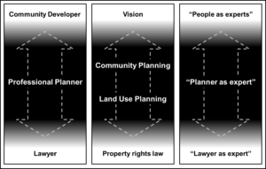
This way of thinking also shapes the responsibilities of a professional planner. As illustrated in Figure 1, we can see planners as a critical link between the field of community development and the practice of law. On the one hand, the practice of professional planning draws from community development, which embodies the future orientation of what a better community should be. The primary concern of community planning is to facilitate a collective vision of this desirable future. The primary concern of professional planning is translating this vision into a land use plan supported by zoning bylaws. This aspect of planning deals with property rights law, working with lawyers to draft bylaws, and implementing these bylaws. These primary concerns of planning are discussed in more detail below.
Most professional planners work for local governments, which include municipalities and regional districts. Professional planners also work in the provincial government, usually in ministries that have some jurisdiction over the use of land, and for consulting firms that serve local governments and development corporations. Within a local government, the responsibilities of a planning department cover the essential, day-to-day aspects of land use planning and long-term aspects of community planning. Collectively, the work of planners covers different areas of expertise, such as community planning, zoning, economic development, climate change and adaptation, public spaces, housing, affordable housing, and transportation, among others.
Figure 1. The practice of professional planning
Most professional planners work for local governments, which include municipalities and regional districts. Professional planners also work in the provincial government, usually in ministries that have some jurisdiction over the use of land, and for consulting firms that serve local governments and development corporations. Within a local government, the responsibilities of a planning department cover the essential, day-to-day aspects of land use planning and long-term aspects of community planning. Collectively, the work of planners covers different areas of expertise, such as community planning, zoning, economic development, climate change and adaptation, public spaces, housing, affordable housing, and transportation, among others.
In British Columbia, professional planners are members of the Planning Institute of British Columbia (PIBC). To become a Registered Professional Planner (RPP), a person must qualify for and pass an examination that is administered by the Professional Standards Board. After passing the examination, a professional planner is eligible for recognition as a Member of the Canadian Institute of Planners (MCIP).
As evident in these introductory remarks, the field of land use planning covers a broad range of topics. Above all, planners must develop skills and knowledge required for understanding what can be done today to make the world a better place tomorrow. Accordingly, planners must understand what and who changes society, drives our economies, shapes our built environments, and affects the health of the environment.
We plan when thinking about what we need to prepare for tonight’s dinner, when we organise for a trip, or when we start thinking about a career after graduating. There are people who sell their services as a financial planner or a wedding planner. However, for all the ways that we engage in planning, there is something different about the profession of planning.
We can highlight specific aspects of the profession by looking, in a playful way, at differences between planning, planning, and Planning.
In a casual way, we plan when thinking about what we need to prepare for tonight’s dinner, when we organise for a trip, or when we start thinking about a career after graduating. There are people who sell their services as a financial planner or wedding planner. However, for all of the ways that we engage in planning, there is something different about land use planning.
We can highlight specific aspects of land use planning by looking, in a playful way, at differences between planning, planning, and Planning.
Think of this small-p version as an informal use of planning, such as the way that we plan our day in order to get things done. In this sense, planning is something we do in a causal way, and without reflecting on what the term means or about our limits to knowing the future.
This italicised version of planning reflects a more deliberate use of the term. Think of planning as the way a company does planning. A company gathers as much information as it can in order to figure out what its customers want, the strengths and weaknesses of their competitors, and steps they must take in order to maximise their market share and profits. In this way, planning refers to a deliberate, systematic approach to knowing as much as possible about the future in order to determine the best steps to achieve a positive outcome.
The capital-p version of planning gets us to the profession of land use planning, which this textbook is about. Not only are land use planners oriented to the future and gather information in a systematic way, they are also people who are trained in the practice of land use and registered by a professional association (see text box).
These three ways of thinking about planning are not used in a formal way anywhere outside of this textbook. Our purpose of thinking about planning this way is to emphasise that planning, when used in relation to professional planning, is different from how it is used in other, more familiar contexts.
To gain further insights about planning, we must account for the following two conditions of planning:
Thinking about the future is entrenched in human nature. Typically, we want ‘the future’ to work out in our favour. For this to happen, we try to gain some control of what lies ahead, to see what the future has in store for us. In Greek and Roman mythology, many of the gods had powers of prophecy, the ability to foresee the future, including Apollo, Phoebe, and Themis. Greek society relied on its oracles to “know” the future and bring it into the present. Of these oracles, the Oracle of Delphi is the most well-known. It was common for Greek society’s leaders to consult with the Oracles before making important decisions about politics and economics.
During the fifteenth century, Western society began a remarkable transformation into its modern form. Over a short period, generations of people witnessed navigation of the globe, separation of state and religion, revelation of the cosmos, emergence of science as a major centre of authority, evolution of agricultural practices, revolution of industrial manufacturing—and a new orientation to the future.
While most people know about modern developments of the scientific method and industrial revolution, few people are aware that how we thought about the future also changed. As our understanding of how the world works increased, society’s confidence in knowing the future also grew. Rather than have the future revealed to us through prophecy, myth, and ritual, our future was open to unknown possibilities; it was an “open” or “discernible” future. It was a future open to unknown possibilities yet also open to human inquiry. As our knowledge of all aspects of nature, society, and the cosmos increased so, too, did our ability to discern probable futures—and then to plan for these probabilities.
In fact, the word “planning” appears in the English language only during the modern era. The need to plan arises only in direct relation with the realisation that humans have some control of our future.
Inevitably, we have to come to terms with our limits of knowing. As Albert Einstein stated, “As our circle of knowledge expands, so does the circumference of darkness surrounding it.” This statement reveals a point of reconciliation: the more we know, the more we become aware of what we do not know. Inevitably, confidence must be reconciled with uncertainty.
Welcome to the world of planning: a way for society to cope with a future that we must know—yet cannot know completely.
This reality makes planning a very curious thing: people are captivated by something we can never fully know, yet we try to know as much as we can about the future to control it. By planning, we strive to maximise what we can know about the future. By the same act, we come to recognise and accept what we cannot know. Planning, in this sense, can be viewed as a functional equivalent of religion, myths, and ritual; in different ways, each perspective helps people deal with an unknowable future in socially acceptable terms.
We must accept that planning is not about controlling or predicting the future or about providing absolute certainty. Rather, we plan because it helps to increase stability and security. Stability has both positive and positivist elements. It is positive in that there is a sense of being able to achieve future prospects of progress and development. It is positivist in the sense that (scientific) control and prediction are predicated on an objectively knowable reality. Security helps increase our sense of comfort with the unknown, by addressing danger, fear, anxiety that comes with uncertainty.
Planning is akin to risk. Specifically, risk is “a matter of a decision that, as can be foreseen, will be subsequently regretted if a loss that one had hoped to avert occurs.” Thus, planning and risk re-inforce each other: planning is about making decisions based on what we know of the future; risk is the consequence of such decisions. We can also think of this relation this way: risk re-inforces the need to plan, which is intended to reduce risk. Both are ways to cope with an unknowable future.
These insights help to define planning as follows: the function of planning is to make the future a visible part of today’s decision-making process. If this definition seems too abstract, think of it this way. You want to ensure that you have a good time while camping this upcoming long weekend. To minimise the risk of having a bad time, you envision what you want to do during the camping trip, as well as the food and equipment you will need. In other words, you will plan. By this act, you make your future activities a part of the decisions you need to make today in order to have a positive trip.
Through this definition, we can also appreciate subtle distinctions between planning, management, and design. While these words are often used interchangeably there are important distinctions to be made between them. Whereas planning is oriented to the future, both designing and managing are oriented to the present. To design is to make decisions in the present, and only after future decisions have been made. From the designer’s perspective, planning decisions provide criteria for completing a design. To manage is to make decisions about decisions that need to be made in the present (among present options). That is, managing is knowing who makes what present decisions and how present decisions should be made. Thus, cities of early civilizations were not planned but designed; the designs were based on myth, tradition, and fate; not in a way that we think about the future today.
An orientation to the future is what makes the profession of planning unique among all professions. Importantly, there is another aspect of professional planning that must be considered before getting into the details of land use planning. We must also consider how the professional planner serves the public interest.
To begin a discussion about ‘public interest,’ we must clarify the term. We can begin by separating “what is in the public interest from those things members of the public are interested in; they are not necessarily the same.” To say that something is “in the public interest” infers that we are not just taking a poll to determine the interest of the majority. Rather, to say that something is “in the public interest” presumes that there is a greater good or common good that transcends individual interests—even if some members of the public do not agree.
The list of elements of public interest related to planning is extensive, as described in Box 1.
Source: Leung, Hok Lin (2003). Land Use Planning Made Plain (Second Edition). Toronto, ON: University of Toronto Press, pp. 5-13
Health and safety
Convenience (to users)
Economic efficiency
Social equity
Environmental quality
Agricultural land (and other resources)
Heritage conservation
Infrastructure
Affordable housing
Visual amenity
Serving the public interest is an obligation of both public officials and professionals. Thus, we can add this understanding of serving the public interest to a definition of planning as a profession. Namely, professional planning is making a desirable future public interest a visible part of public decision-making processes.
In the late nineteenth century, the future public interest in the well-being of cities became immanent. Conflicts among uses of land, especially livestock within cities, the need for better sanitation, poor water quality, and worsening public health conditions, all contributing to a decline in the quality of life within urban areas. The worsening problem of urban centres made clear that the broad interest of the public interest was at stake. The profession of planning took shape in and from this context. Thus, in addition to planning’s function of binding the future in decision-making, the practice of professional planning fills the additional, specific function of binding the future public interest to present decisions.
In theoretical terms, planning can be defined as making decisions on what decisions need to be made in the future, thus binding the future to the present by fixing finite future possibilities through the structures of decision-making processes. In simpler terms, to plan is to make the future a visible, and discernible, part of modern decision-making processes. Professional planners make a future public interest a visible, and discernible, part of public decision-making processes in the present. Hence, the function of planning is only relevant to a future-oriented society and a future-oriented society requires planning to function. Furthermore, while not all practices of professional planners are aimed at the future, the function of planning always is.
In this text we view land use planning through a lens of Canadian law, but not exclusively. Through the cases and applications, we also examine land use planning in relation to Indigenous peoples and law, including Indigenous title and rights (see below), government-to-government (or joint) land use planning, and Indigenous protected and conserved areas (IPCAs).
People usually associate land use planning with cities, and we focus here on these urban environments to introduce land use planning. Urban land use planning is most easily recognised by maps that show different land use zones. Figure 2 is an example of a land use zone map for the City of Vancouver’s downtown area. Each colour on this zoning map represents a different type of land use known as a zoning district, designated as residential, industrial, commercial, parks, etc. That is, the colours show which areas of the downtown Vancouver are designated for what purposes.
Figure 1. City of Vancouver, land use zones, downtown area.
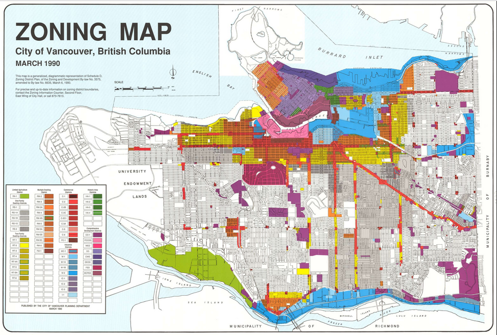
More specifically, and technically, a zoning bylaw is the legal way to regulate the types of land uses allowed for areas of a city, as well as where a building can be located on a site, the maximum height and size of a building, and other provisions. Zoning regulations for a city like Vancouver are extensive and very detailed. For example, Vancouver has more than 50 zoning districts just for residential uses. There are dozens more zoning districts that cover industrial, commercial, historic, comprehensive, and agricultural uses. These regulations, which cover every property in a city, are set according to city-wide goals and priorities.
The relation between area-wide goals and zoning is very important, as it reveals the core areas of responsibility of a professional planner. These responsibilities range from creating a long-term vision of what a city should look like in, say, thirty years to what decisions we must make today to achieve that vision. At the broad end of the scale, planning is about envisioning what a city should look like in the future so that it is the best possible place to live, work, and play. It is a vision of a desirable future for a city as a whole. This aspect of planning is often referred to as long-range community planning. At the other end of the scale, zoning represents the outcome of land use planning processes, in which the broader priorities are translated into detailed regulations that dictate how land should be used. This aspect of land use planning is often referred to as current planning. In sum, as reflected in the definition of planning by the Canadian Institute of Planners (CIP): “Planning addresses the use of land, resources, facilities, and services in ways that secure the physical, economic, and social efficiency, health and well-being of urban and rural communities.”
What, then, is a land use plan? According to Hok Lin Leung, a land use plan is a “conception about the spatial arrangement of land uses, with a set of proposed actions to make that a reality.” This definition emphasises the spatial aspect of land use plans. In different terms, a land use plan is “The official statement of a…legislative body which sets forth its major policies concerning desirable future physical environment.” This view of land use planning highlights the legal foundation of land use plans.
The purpose of this book is to engage learners in different contexts and explore different legislative frameworks that govern the uses of land. Each case and application is an example of a type of land use planning in British Columbia, including urban, rural, regional, First Nations reserves, agricultural, and protected areas. In each context, one must examine the corresponding legislative framework, which includes legislative acts and regulations of the provincial government and bylaws of local governments.
Depending on the type of land use, under common law, a legislative framework may be focussed on one or all levels of government, whether municipal, regional, or provincial, and sometimes federal. Legislation, including laws, regulations, statutory plans, and implementing bylaws, is the most important element of a framework, which is complemented by policies and governance mechanisms.
A framework is based on the “enabling” legislation; that is, the legislative act (i.e., law) that enables a government or agency to govern land uses. For example, the Local Government Act (RSBC 2015 Ch. 1 Part 14) enables local governments to complete Official Community Plans (OCPs) and zoning regulations; the Park Act (RSBC 1996 Ch. 344) enables the provincial government to establish parks and protected areas; the Agricultural Land Commission Act (SBC 2002 Ch. 36) enables the provincial government to establish the Agricultural Land Reserve and the Agricultural Land Commission. Regulations that are adopted pursuant to the act usually set out details for creating and implementing the land use plan. Policies can be either enforceable or aspirational. Governance mechanisms include tribunals, such as the Agricultural Land Commission (ALC) and Oil and Gas Commission (OGC) at the provincial level, and planning advisory committee at the local level. Table 1 shows common elements of legislative frameworks that learners will encounter in the land use cases and applications covered in this text.
Table 1. Common elements of a legislative framework for land use planning.
POLICY | LEGISLATION | GOVERNANCE | |
PROVINCIAL | Policies | Laws (Acts) Regulations Orders-in-Council
| Tribunals |
REGIONAL | Land and Resource Management Plans (LRMPs) Sustainable Resource Management Plans (SRMPs) Strategic Plans Economic Development Strategies Policies
| Regional Growth Strategies Official Community Plans Zoning Bylaws | Planning Advisory Committee |
MUNICIPAL | Strategic Plans Economic Development Strategies Policies
| Official Community Plans Zoning Bylaws (and regulatory tools) | Planning Advisory Committee |
It is easy to assume that land use planning is about land. However, technically, the purpose of planning is about the use of a land. Correspondingly, when we consider uses of land, we are dealing with property rights. As we explore how land use planning relates to property rights, we will also discover how the work of a professional planner is tied to the practice of law. The relation between land use and property law is covered in detail by Howard Epstein, a lawyer who wrote a book about land use planning in Canada. As Epstein explains, “Modern property law sees itself as being concerned with ‘legal relations among people regarding control and disposition of valued resources’.”
As Roy Vogt explains, property rights refers to a bundle of entitlement, i.e., rights, that governs the use of things. These things can be an idea, such as intellectual property, or an object, such as personal property. Property also refers to land, and since land is both sought-after and in limited supply, we use a system of rights to administer its use.
While property has to do with things, modern property theory focusses not on the things themselves but on the kinds of rights required to control their use. In general terms, property rights of land encompasses a bundle of three rights: use; control; and disposition.
Use rights entitle one to occupy, derive income from, or extract natural resources from land.
Control (or enjoyment) rights concerns the right to be protected from trespass, nuisance, or expropriation (i.e., control others’ uses).
Disposition rights concern the right to sell, lease, subdivide, or bequeath lands.
Instead of referring to different combinations of rights as “bundles,” the legal term we use is tenure. Tenure refers to the legal regime in which interests in land are held. Although the term tenure may not be used often, people are familiar with different types of tenure, which exist in the form of a permit, lease, licence, grant, and other legal regimes. When a person “owns” a house, this form of tenure is called fee simple, which represents the fullest form of rights to land, including the right to use, control (enjoy), and dispose.
In BC—notwithstanding Indigenous rights and title, which is addressed below—all land is ultimately owned by the Crown. Correspondingly, all rights to land are held directly or indirectly by some kind of tenure from the Crown.
The general purpose of land use planning can be adopted by and applied in any societal context. However, when we consider the legal foundations of land use planning, we must distinguish between rights and title recognised by Canada law and rights and title under the laws of Indigenous Nations.
Indigenous rights derive from elements of distinctive practices, customs, and traditions integral to the culture of an Indigenous Nation. From a common law perspective, Indigenous rights to land are recognised as unique property rights. Such rights include the right to access and use land for hunting and trapping. These rights are sui generis. That is, they are recognised as existing prior to the European assertion of sovereignty and to the establishment of property rights under common law in Canada. Indigenous rights are a claim recognisable, protected, and enforceable by Canadian common law.
Indigenous title is a form of property right specific to land; it is a sub-set of Indigenous rights. Indigenous title, like other Indigenous rights, is a special right recognised as sui generis. In other words, Indigenous title to land is not derived from Canadian law. An Indigenous right (to hunt, for example) can exist independently of Indigenous title to land. Like other property rights under common law (but not the same as), Indigenous rights to land correspond to their occupation, use, and control of ancestral lands. Although Indigenous laws may not use these specific terms, these laws are premised on property rights, as embedded, for example, in the existence of traditional territories.
Under the Constitution Act, 1982, Indigenous rights to property do not include disposition rights. Indigenous people cannot sell rights to their land; they can only voluntarily surrender their land to the Crown through agreements (e.g., treaties). Also, Indigenous rights and title to land are recognised as communal; they are not held by any individual Indigenous person but by Indigenous nations.
Legal recognition, as well as general understanding, of Indigenous title and rights are long-standing issues that have been subject to many cases before the Supreme Court of Canada. Although the process has been slow, each court decision contributes to an evolutionary relation between Canada law and Indigenous law and, correspondingly, between modern property law and Indigenous rights and title. For a long time, modern property law was the only legal regime applied to land, including the Indian Act. The court decisions acknowledged the Crown’s obligation to recognise Indigenous rights and title; however, in practice, recognition still left Indigenous rights and title to be accommodated largely within land use planning processes. Today, government-to-government land use planning processes are finding ways to work with Canada law and Indigenous law on a side-by-side basis.
3
Creating the materials for this book was not possible without assistance and support from many people.
In 2010, David Connell learned that he would be teaching a fourth-year capstone course on land use planning at the University of Northern British Columbia (UNBC). As part of their Bachelor of Planning degree, students in the course study urban, rural, natural resources, and First Nations planning. After reviewing available textbooks, Connell did not find one that would meet the needs of the course. The available books tend to focus exclusively on urban planning or only briefly on other types of land uses. None of the books focus on only land use laws and regulations in British Columbia. Connell decided to create new materials that would cover a breadth of land use planning in the province.
Connell applied for and received funding to help prepare the new course materials. Connell is grateful for the initial funding provided by the BC Real Estate Foundation Partnering Fund, with which he hired a Student Research Assistant to conduct research and prepare draft materials.
The following people were members of the project team in 2010.
David Connell, RPP MCIP
Connell is a Professor at UNBC in Ecosystem Science and Management. Connell developed the overall concept for the course materials, designed the structure, and prepared final versions of all materials. Annually, Connell reviews, updates, and revises the materials prior to teaching the land use planning course. Since 2010, he has authored many new materials.
Kerry Pateman, RPP MCIP
Pateman was a Senior Instructor at UNBC and a member of the project team. Pateman drew upon her many years as a professional planner to ensure that the course materials were accurate and relevant. To the benefit of the whole project, Pateman always emphasised the practical aspects of what we tried to capture in writing.
Roy Neilson, RPP MCIP
Neilson was a senior undergraduate student at UNBC and a member of the project team. Neilson was hired as a Student Research Assistant to support the writing process. Neilson gathered relevant information and prepared early drafts of most of the cases and applications. When looking at the course materials today, we remain impressed with the quality of Neilson’s creativity and insights that provided the foundation for materials that remain relevant many years later.
Richard Krehbiel
Trained in law, Richard taught environmental and aboriginal law courses at UNBC and acted as an informal consultant for the project. The team turned to Rick frequently to explain intricacies of legal terms and to ensure that course materials were presented accurately from a legal perspective.
The teaching materials developed for the land use planning course were developed initially as a team. The materials were first used in the land use planning course in January, 2011. Connell’s continuous review of the materials in preparation to teach means that the current materials, while retaining the original scope and intent of each case study, are now substantially different.
The many contributions people made to each of the chapters and case studies over the years are described below.
This chapter draws from Connell’s past publications on planning theory, specifically:
Case. Prince George: Planning for Low Growth
The case draws heavily from Jason Llewellyn’s Master’s thesis on the historical development of the City of Prince George. Neilson prepared the initial draft. Llewellyn, Pateman, and Dan Milburn contributed as interviewees.
Application. Area-wide Growth Management
The content of this case was inspired by the City’s long-term integrated sustainability plan, which had just been completed. Neilson prepared the initial draft.
Application. Downtown Revitalisation
Llewellyn provides a comprehensive account of the City of Prince George’s historical efforts to develop the downtown area. Neilson developed the focus on regulatory tools and prepared the initial draft.
Application. Urban Fringe
Connell authored this application. The contents draws in part from Connell’s involvement as a member of the public responding to a re-zoning application in the City’s urban fringe.
Case. Crown Lands in the Bulkley Valley
Neilson developed the story about the Town of Smithers and prepared the initial draft. Llewellyn and Raymond Chipeniuk contributed as interviewees.
Application. Access to Rural Subdivision
Neilson identified the application for the driveway access and prepared the initial draft. Llewellyn provided helpful insights about how to interpret the application for the driveway.
The following guest speakers participated in in-class discussions and contributed their professional insights about rural planning and, specifically, about access to rural subdivisions: Tricia Klein, Authorizations Specialist, Crown Lands, Ministry of Forests, Lands, Natural Resource Operations and Rural Development; Katie Ireland, Provincial Approving Officer, Ministry of Transportation and Infrastructure
Case. Kemess North: Rights, Title, and Subsurface Resources
The Kemess North mining proposal was significant for many reasons outlined in the case. Neilson identified this proposal and environmental assessment as a platform to discuss government-to-government land use planning. An anonymous participant in the Kemess North assessment review contributed as an interviewee.
Application. Joint Planning in Haida Gwaii
Neilson identified Haida Gwaii as an example of government-to-government land use planning.
Case. McLeod Lake Indian Band: An Entrepreneurial Spirit
McLeod Lake Indian Band was developed as a case study because Pateman had extensive experience working with First Nations in Central Interior BC and Lucy Martin, an undergraduate student at UNBC, was a member of the McLeod Lake Indian Band. Several members of the McLeod Lake Indian Band joined us in-class the first time the materials were used.
Application. McLeod Lake Indian Band: Proposal for Development
Neilson identified the Bear Lake Reserve parcel as the subject of the application and created the proposal for development, including the three options. In 2022, Tania Solonas, Land Management Officer, McLeod Lake Indian Band, contributed as a guest speaker, providing additional context and up-to-date information about land use planning.
Case. Planning for Agriculture: Land, Food, and Community Need
Materials draw from Connell’s research program, including published policy briefs and journal articles.
Application. ALR Exclusion in South Cariboo
Neilson selected the Horse Lake application to the Agricultural Land Commission.
Protected Areas Planning
Case. Ancient Forests of the Upper Fraser River
The case study on the ancient forests of the upper Fraser River watershed is based on Connell’s study of socio-economic benefits of non-timber uses. In turn, Connell’s work draws from the direct and indirect contributions of many people. Two UNBC graduate students also contributed as members of Connell’s research team: Jessica Shapiro studied old-growth forest values and the ancient forest; John Hall studied socio-economic impacts of eco-tourism and the ancient forest. Hugh Perkins and Kathy Juncker were sources of information and inspiration, as well as Save the Cedar League.
Application. Protecting the Ancient Cedars.
Dr. Darwyn Coxson, UNBC, is the author of the three options for areas to increase protection of ancient cedars. Andrea Somerville, Planning Section Head, Omineca Peace Region, BC Parks, Ministry of Environment and Climate Change Strategy, contributed as a guest speaker in 2022. In addition to improving our understanding of protection for the ancient forests, Somerville provided important insights about land use planning for protected areas.
All of the Learning Modules were created after the initial project was completed, with several of the Modules created in conjunction with preparing this book in 2023.
The first Learning Modules were created as products of revising existing case study materials (with attributions described above). These Modules include the following:
Connell created the following Learning Modules, often drawing upon Government of BC sources:
Glen Thielmann (Teacher, SD57; Pro-D Chair/Fund Admin; Lecturer, UNBC School of Education) and Bill Masich (Teacher SD57) provided initial support and encouragement to focus on secondary education. Thielmann also supported efforts to generate awareness of the book among post-secondary teachers in BC through his role as Pro-D Chair.
I
1
URBAN PLANNING CASE STUDY
The Urban Planning Case Study centres on the City of Prince George and its surrounding area in the Regional District of Fraser-Fort George. This case describes the historical development of the City. Three applications cover the topics of downtown revitalisation, growth management, and urban fringe management.
The historical development of Prince George, BC, provides the context for understanding many challenges of urban planning over the past 100 years. The City’s history begins with early townsites and the dispossession of Indigenous lands of the Lheidli T’enneh and leads to periods of uncontrolled growth and, later, an extended period of no growth. Learners consider the roles and contributions of the professional land use planner throughout the history of the city’s development, including the legislative and regulatory tools employed to both support and discourage development. The case encompasses elements of public, private, and government interests, the function of various land use plans, and the implementation tools that have helped shape BC’s ‘northern capital’ over the past one hundred years and how will shape it for the foreseeable future.
The learner is charged with recommending a particular growth management strategy the City of Prince George should follow to achieve its vision of a desirable future. Choosing among the four growth management options, the learner must include justification premised upon public, private, and government interests.
To overcome barriers to revitalising the downtown area, the City of Prince George is considering a bundle of regulatory tools and financial incentives to aid in neighbourhood-level re-development efforts. As a long-range planner for the City of Prince George, the learner is responsible for recommending to City Council which financial and regulatory tools will assist continued development in downtown Prince George.
As an expert in urban planning, the learner must advise an ad hoc advisory committee established by the Regional District of Fraser-Fort George about how to improve the legislative framework for land use planning (Official Community Plans, zoning bylaws). The learner’s task is to advise the committee regarding the relative strengths of each of the following options and provide evidence of any critical deficiencies: status quo; update current OCPs and zoning by-laws; create fringe area OCP and zoning by-law that covers all or parts of the area immediately surrounding the City of Prince George; create a Regional Growth Strategy.
This module describes a range of planning tools available to local governments to help control and direct urban development. These tools are regulated under provincial legislation.
This module describes development projects that have been completed in the City’s downtown area since 2011. Collectively, these property developments help learners understand the current state of downtown Prince George.
The Local Government Act enables a regional district to adopt a Regional Growth Strategy (RGS) for all or, with permission, part of a regional district. This module describes and explains what a RGS is and what it aims to do.
2
URBAN PLANNING CASE STUDY
The historical of development Prince George, British Columbia, provides the context for understanding many challenges of urban planning over the past 100 years. The City’s history begins with early townsites and the dispossession of Indigenous lands of the Lheidli T’enneh and leads to periods of uncontrolled growth and, later, an extended period of no growth. Learners should consider the roles and contributions of the professional land use planner throughout the history of the city’s development, including the legislative and regulatory tools employed to both support and discourage development. Learners are encouraged to analyse the elements of public, private, and government interests, the function of various land use plans, and the implementation tools that have helped shape BC’s ‘northern capital’ over the past one hundred years and how will shape it for the foreseeable future.
Upon arrival in Prince George, British Columbia, a visitor is likely to first notice its industrial developments. The pulp mills, rail yards, and supporting industries are some of the most prominent features of the City, which make Prince George typical of many cities and towns in rural British Columbia. Visitors will also notice the requisite ‘big box’ store developments, casino, golf courses, and chain restaurants, which make the City typical of most cities in North America. What visitors may not notice immediately, but will come to appreciate if they stay long enough, is a healthy network of social, arts, and cultural activities. Yet, what is least obvious is how the City arrived at its present state. While the proximity to the Nechako and Fraser rivers suggests why the City is located where it is, the current pattern of development seems to defy many principles of good urban design.
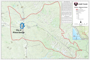
The City of Prince George is located on the unceded traditional territory of the Lheidli T’enneh and ancestral lands of the Dakelh (Map 2). The Dakelh are believed to be central BC’s first residents and are ancestors to the Lheidli T’enneh. The name of the latter can be translated as follows: Lheidli means “where the two rivers flow together” and T’enneh means “the People.”
Map 1. Prince George located in the Regional District of Fraser-Fort George

In the early twentieth century, the few permanent residents of European ancestry were employees of the Hudson Bay Company. During this time, the modest settlement of Fort George served as an important fur trading post. This settlement would be permanently changed when it was discovered that the Grand Trunk Pacific Railway would be travelling through Fort George, an announcement that set off a flurry of land speculation and development in the area. From here forward for Prince George, like other settlements of the North American West, “[n]othing could be further from the truth than the notion that Western towns originated as spontaneous crossroad hamlets that grew slowly, incrementally, and randomly, without guidance of direction.” To the contrary, Prince George is the result of numerous efforts to guide and restrict growth.
Notwithstanding numerous planning initiatives to fulfill its destiny as B.C.’s “northern capital,” Prince George has not achieved most of its predicted growth scenarios. This shortcoming has presented significant difficulties to direct growth and development throughout its history.
Map 2. Traditional territory of the Lheidli T’enneh (unceded)
The first townsite plans (Figure 1) at the confluence of the Nechako and Fraser rivers were registered in 1909/10 by a group of investors known as the Northern Development Company. The new townsite was called South Fort George. Nearby, a competing townsite called Central Fort George was being built by another investment group, the Natural Resources Security Company, who promoted Central Fort George as having huge development potential. The townsites of South and Central Fort George were home to roughly 1,500 residents and thousands of temporary construction workers who worked in the region.
Figure 1. Map of early townsites and Fort George Indian Reserve in 1910
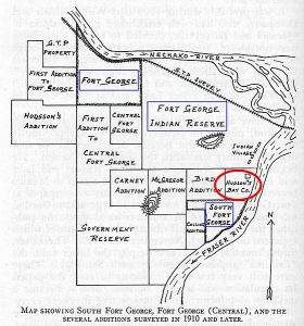
All the while, the influential Grand Trunk Pacific Railway was moving ahead with its plans for another townsite. Grand Trunk solicited the federal government for purchase of the Fort George Indian Reserve lands. After extended rounds of negotiations, and highly questionable tactics, the dispossession of the Reserve lands to the Grand Trunk Pacific Railway was completed in 1912. Building at this third townsite commenced the following year. Following the announcement that the train station would be located within Grand Trunk lands, the newest townsite was incorporated in 1915 as the Town of Prince George.
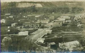
When the first train arrived in 1914 there was already sufficient investment in the regional forestry industry to ensure prosperity for the area. At the peak of speculation, the greater Fort George area boasted fourteen completed subdivision plans, equalling roughly 22,800 lots in the three separate townsites.
For the two original townsites, over two-thirds of the subdivided lots had gone undeveloped, and much of this vacant land was abandoned by its owners and reverted back to the provincial government. Although South Fort George managed to maintain a small population, Central Fort George was eventually completely deserted. Meanwhile, the Town of Prince George had quickly established itself as the industrial and administrative capital of Northern BC.
During the war years from 1941-45, Prince George’s population expanded from roughly 2,000 to 3,800 people; an annual increase of 18%. Many of the new migrants were attracted by the expanding forest industry and the increased provision of services. However, due to wartime lumber restrictions, much of the new development was poorly constructed and without basic sanitary infrastructure. Adding to these woes in 1942, Prince George “was to be invaded and literally taken over by one of the largest army camps in Canada,” with roughly 10,000 soldiers temporarily taking residence in the bustling town.
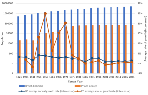
The post-war era was the start of a long period of sustained population growth for Prince George. As illustrated in Chart 1, from 1921 to 2021, average annual growth in the City of Prince George outpaced that of a prospering British Columbia at times, although the pace of growth fluctuated wildly. As noted below, several of the population increases were due to expansion of municipal boundaries, thus encompassing the population of rural areas. As the City expanded both demographically and economically, so too did the challenges of managing growth, with low-density, haphazard development spreading beyond the Town of Prince George into South Fort George, the former Central Fort George, and surrounding areas.
To accommodate the influx of new residents who were arriving at an accelerating pace in the 1950s and to deal with the increasingly dilapidated and disorganised cityscape, the City recognised that some form of land use planning was required. Subsequently, this need was addressed in several capacities, including the following:
Chart 1. Population Growth and Average Annual Growth (%) in Prince George and British Columbia: 1921-2021
As well, in 1957, in order to gain more control over development, Prince George acquired the land rights to all undeveloped parcels within city limits from the Province, who still owned large tracts of land following the initial subdivision boom. The effectiveness of this bold strategy is well illustrated by Desmond Parker, the City’s de facto planner from 1957-75, who reflects:
By implementing a wise policy of containment, made possible by the public ownership of land, the City has forced development into the previous lower density areas and achieved a saturation of existing services. The shortage of land and the definite policy of inhibiting premature subdivision, coupled with the rapid growth of the community, have brought about a natural renewal.
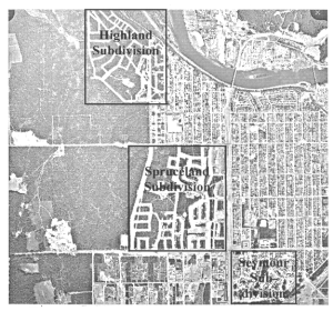
This “natural renewal” was a form of control over development. Having gained an upper hand, the City approved three new subdivisions between 1958 and 1965: Seymour, Spruceland, and Highland (Map 3). These subdivisions were developed as urban infill and also eschewed the monotony of gridiron subdivision for the aesthetics of neighbourhood design.
Each new subdivision was planned to function as a self-contained neighbourhood complete with commercial and educational services within reasonable distance of all housing units. The neighbourhood concept was such a success that, thereafter, the City required all private developers to incorporate neighbourhood-level planning into subdivision proposals. The influence of this planning policy is evident by the College Heights neighbourhood established in the mid-1970s.
Map 3. Planned neighbourhood subdivisions in Prince George, BC (1965)
In the late 1960s, due in part to the establishment of three new pulp mills, Prince George (pop. 25,853) was Canada’s fastest growing city with an annual average population growth of 15.3%. During this period the city completed some progressive land use planning including additional boundary expansions, the creation of a new zoning bylaw (1967), and an Official Community Plan (OCP) (1969). However, the growth that was taking place outside city limits along the Hart Highway and North Nechako Road severely compromised on-going efforts to develop a comprehensive plan. In 1969, the population of these so-called “rural slums” was estimated to be around 10,000.
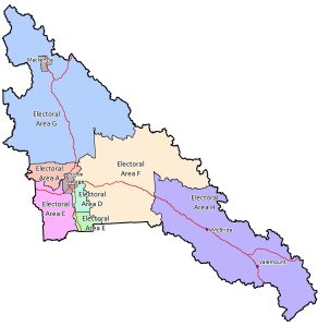
The Regional District of Fraser-Fort George (RDFFG) was established in 1969, consisting of eight Electoral Areas (from A to H), as shown in Map 4. The Regional District adopted its first Official Regional Plan in 1972; each Electoral Area has an OCP. These steps helped to improve rural building and development standards. At this time, the greater Prince George area was projected to have a population range anywhere from 325,000 to 470,000 by the year 2000. To accommodate these projections, the Region’s Official Regional Plan supported the development of three ‘satellite towns’ directly abutting the ‘urban core’ of Prince George, thus supporting rampant subdivision development in the surrounding areas. By 1974 the estimated population outside City limits had increased to roughly 25,000.
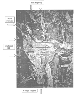
The Regional District’s plan for a “Greater Prince George,” ambitious even in its day, was abandoned in 1974 after the City’s newly created Planning Department proposed a very aggressive boundary extension. The expansion would incorporate large areas beyond the “bowl” to include South Fort George, Peden Hill, Cranbrook Hill, College Heights, Beaverly, Blackburn, North Nechako, and the Hart (see Map 5). The effect was to bring the adjacent rural populations within City limits, and more than double the City’s population to over 60,000 people. This form of multi-municipality restructuring took place within a provincial initiative that also guided restructuring in Kamloops, Kelowna, and Nanaimo. In Prince George, although the restructuring was mandated by the province, local politicians supported the action.
Map 4. Regional District of Fraser-Fort George, Electoral Areas
While this strategy was initiated by the Province of British Columbia and supported by the City of Prince George and the majority of city residents, it was vehemently opposed by rural landowners and developers who (correctly) feared increased taxation rates and development regulation. This divided support was reflected in a referendum, which saw the plans for restructuring narrowly pass by 55.3% in the vote held on November 2, 1974. Save a few minor adjustments, the form of present day City of Prince George and Regional District of Fraser-Fort George had been established.
Map 5. Post-restructuring Prince George, BC (1981)
What followed was a series of public hearings that served to intensify the conflict between the City and some members of the development industry. Critics of the plan focused upon the liberal allocation of greenspace within the Hart area and the phased development designations that would greatly restrict rural expansion until a future date. Despite significant efforts to incorporate public input, the City was nonetheless accused of “trying to stifle free-enterprise by forcing a community plan down residents’ throats.” As reported in the same newspaper article, the prevailing attitude of the opposition is perhaps best illustrated by the sentiment of a local land dealer who declared in a public hearing, “We should be planning for today…not for tomorrow.”
Notwithstanding challenges, the OCP and zoning bylaw passed Council relatively unscathed in 1979, largely abetted by the continued growth that allowed the City to push back against poorly planned development. However, these achievements were not without casualty. In 1978, the City’s first Planning Director resigned after being lambasted with “allegations of incompetence, lying, personal vendettas, and bias.” The City’s new growth management policy was complemented by RDFFG’s updated Official Regional Plan, also approved in 1979, that prioritised industrial and commercial development in the rural fringes, and offered comparatively modest allocations for rural residential lifestyles.
By 1980, the City had gained control of growth in greater Prince George. Unfortunately, the previous 40 years of growth outside of the city limits, with insufficient planning and development controls, had resulted in a very dispersed urban form outside of the bowl area.…[The] City was now responsible for providing and improving the services and amenities to these areas, and in dealing with the numerous functional problems associated with poorly coordinated and organized development.
In 1981, Prince George had a population of 67,559, which made it the second largest city in BC behind Vancouver and ahead of Victoria (population 64,379). This height of development marked the end of the City’s era of unprecedented growth. What followed represented a new chapter in the life of the City full of completely different challenges.
The new City plans were clearly focussed on managing growth, with a projected population of 98,500 by 1991. As stated in the OCP, “[T]o accommodate the projected growth, very large areas were designated for residential development and extensive tracts were shown for industrial use.” Subdivision developments in the newly incorporated areas continued with an all-but exclusive emphasis on single-family dwellings, which is a source of the ‘urban sprawl’ that we see in Prince George today. However, while the City was sprawling, its economy was shrinking. “It is somewhat ironic that once the City of Prince George became able to properly plan for its future growth, the province would be subject to an economic recession that would last over ten years, resulting in little or no growth” in the city.By 1981, the form and structure of the city was established as a sprawling city. There was good planning done, but based on huge growth. We’ve continued to allow sprawl, there’s no question. And I’ve heard planners say that the public wants single-family residential in the standard suburban subdivisions that we have. So the question needs to be asked of planners and the city, ‘Is it okay?’ Kerry Pateman (RPP MCIP), Former planner, City of Prince George
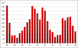
The economic recession left an indelible impact on the development of Prince George. After strong years of housing starts in 1982 and 1983, the market collapsed (Chart 2). During the height of the recession, housing starts suffered a decline of over 600% while average population growth stagnated at 0.1% annually (Chart 1). Vacancy rates reached a high of 15%. The low growth rate of the population has remained flat to this day.
Chart 2. Housing Starts in Prince George: 1982-2009
In the early 1990s, the construction of a new courthouse, civic centre, and the University of Northern British Columbia (UNBC) breathed new life into the City, as many heralded the dawn of a new era for Prince George. There were modest gains in population and housing starts, although not close to the fever pitch of the ‘boom era’. Meanwhile, the outdated population projections of the 1979 OCP were discarded in favour of a new plan in 1993. The 1993 OCP was considered a significant change in the City’s approach to growth management and guided by the following projections and principles:The developers don’t care where they make their money – if it comes out of the left hand pocket or the right hand pocket. If we can create a way to focus growth, but still point them to development opportunities where they’ll make money – hopefully even more money – that’s good, right? You can’t have a plan that’s not economically sustainable.…The more challenging issue is how you transition from pretty much allowing anything, to a more focused, infill-type development while acknowledging there are some embedded investment interests in these lands. some cases, it’s just the planning; but in others, the developers have contributed to actual capital works. To simply cut people off sends a very problematic signal to the investment community, runs counter to all our planning for the last nine years, and potentially, is also an unjust enrichment – where the City has been unjustly enriched by their capital infrastructure investments. So there’s a few legitimate arguments they’re bringing to bear. Dan Milburn (RPP MCIP), Former Manager of Long Range Planning, City of Prince George
In addition, the 1993 OCP espoused tenets of winter city infrastructure and aesthetics, healthy communities, and sustainability. These ideals were promoted even further in the 2001 OCP, whose vision statement expanded upon ideals of environmental stewardship, social responsibility, economic diversity, and public participation. Perhaps more tangibly, the 2001 OCP formally recognised growth management as a planning priority, dedicating an entire chapter to principles and policies intended to achieve a vision of “concentrated growth.” One such policy involved the creation of a long-term Urban Development Boundary, shown in Map 5, that spatially delineated the maximum allowable extent for future development. Unfortunately, hindsight has suggested that the seemingly progressive policies contained within in the 2001 OCP have “not prevented any development that wanted to happen.”
Map 5. Urban Development Boundary for Prince George, BC

From a city’s perspective, the goal isn’t necessarily to have rampant growth just to increase the tax base, although some might say that. At the end of the day, there’s a lot of cost that comes with that growth. So, are we net gaining or losing by doing new development? Dan Milburn (RPP MCIP), Former Manager of Long Range Planning, City of Prince George
The Prince George of the early twenty-first century is focussed on economic development and downtown revitalisation. Economic development has been moving forward in the face of the long-term effects of the Mountain Pine Beetle epidemic, the crisis of the global financial system, the collapse of the U.S. housing market, and COVID. Tapping into the global transportation system is the catalyst for airport expansion and its related developments, including construction of the boundary road and industrial development.
As for downtown revitalisation, recent plans and public consultations have added to on-going efThere’s always the belief that you’re going to continue to grow. And, as soon as the City enters into a discussion about developing private land, there’s a belief by the developer that the City has accepted that the land will be developed. There’s so much perceived political commitment to landowners, that they have some sort of right, that it’s going to take a really strong city counsellor, or planner, to turn that around and say, ‘Sorry, you will not get to develop.’ we haven’t grown in population, it doesn’t matter how many community plans we bring in that say ‘We’ve got a 1.5%, 3%, 0.25% growth rate.’ Unless you’re willing to make some strict statements, you’re not going to get a new form of community. Kerry Pateman (RPP MCIP), Former planner, City of Prince Georgeforts to improve the City as a whole. Principles of Smart Growth and new urbanism have been incorporated into visions of what a vibrant Prince George might look like. In 2015 the City celebrated its 100th anniversary. It also hosted the Canada Winter Games the same year. However, although never short of ideas for future development, the City of Prince George of today remains bound to its reality of low growth.
3
URBAN PLANNING CASE STUDY
To overcome barriers to revitalising the downtown area, the City of Prince George’s Department of Planning, Development, and Infrastructure Services is considering a bundle of regulatory tools and financial incentives to aid in neighbourhood-level re-development efforts. As a long-range planner for the City of Prince George, you are responsible for recommending to City Council which financial and regulatory tools you feel will assist continued development in downtown Prince George. You may apply one or more specific tools to the entirety of the downtown, to a portion, or to a single lot, or a combination thereof. Provide reasons for either incorporating or rejecting initiatives within your staff memo to Council. In addition, provide an explanation as to how your recommendation addresses the need for: (1) new commercial developments; (2) affordable, medium-density housing; (3) façade improvements, and (4) green buildings.
Format your assignment as an internal staff memo to Council (example on Blackboard). Length should be 800 to 1,000 words.
Revitalising the downtown core is a long-standing priority of the City of Prince George. In its current Official Community Plan (OCP) (Bylaw 8383, 2012), the City’s vision includes a “vibrant downtown.” This vision is supported by a set of land use objectives and policies (s. 8.3), including the following:
The heart of the city, the downtown functions as the civic and cultural centre of Prince George, containing key cultural, civic, and recreational amenities, offices, shopping, and accommodating significant housing. Buildings may be larger in scale, with a mix of towers and lower forms.
For the purposes of this study, ‘downtown’ is defined formally by the Prince George Business Improvement Area, as depicted in Map 1.
Map 1. Downtown Business Improvement Area, City of Prince George

Major downtown revitalisation efforts have been undertaken in Prince George since the early 1960s with some success; however, the vast majority of revitalisation efforts have either not been implemented or only partially implemented. A brief chronology of downtown revitalisation initiatives includes the following plans.
“The Miracle Plan” (1964) – This was an ambitious development proposal that would see a dome being placed over a five-block area in downtown Prince George. The dome was designed to provide protection from the elements during the City’s harsh, long winters. While the proposal was derailed at preliminary stages, it nonetheless provided the impetus for a 1965 report, Space Requirements: Central Business District, which identified risks concerning reduced economic vitality in the downtown core, due in part to the newly established Parkwood Mall and Spruceland Shopping Centre. Despite the report’s recommendations to stringently centralise retail activities, subsequent development would occur to the contrary (i.e., Hart Highway Shopping Centre, Pine Centre Mall, Westgate Commercial).
“The Centrum Plan” (1966) – Significant features of this plan, which was developed for an estimated population of 140,000, include the transformation of 3rd avenue into a covered shopping boulevard, an elevated monorail from Parkwood Mall to downtown, a convention centre, and zoning for high-rise residential and office buildings. While the majority of this plan went unrealised, the Centrum Plan significantly influenced the present-day locations of the Bob Harkins Public Library, the Civic Centre, and the Two Rivers Art Gallery.
“The Cadillac Fairview Town Centre Plan” (1980) – From a number of redevelopment proposals, the City selected the Town Centre Plan as best suited to achieve the objectives outlined in the four-volume Central Business District Study (1980). The Town Centre Plan proposed converting four downtown blocks into a covered, two-storey shopping mall complex, complete with a new town centre. Due to significant public opposition, the plan was eventually abandoned in favour of an expansion of nearby Parkwood Mall.
“The City of Prince George Downtown Revitalization Plan” (1992) – This plan represented the combined multi-year efforts of numerous stakeholders operating under the umbrella of the Prince George Region Development Corporation. Whereas previous plans had been limited chiefly to economic considerations, an important component of the Prince George Downtown Revitalization Plan (PGDRP) was its recognition of the importance of environmental and social values in downtown redevelopment. While the PGDRP successfully guided the development of the courthouse plaza in 1996, a number of other initiatives recommended in the strategy were vehemently opposed and eventually defeated by downtown business owners.
“Downtown Prince George Concept Plan” (2009) – This planning exercise created a design-based vision for Prince George circa 2035, based on incorporation of eight “Smart Growth” principles. The Mayor’s Task Force for a Better Downtown was responsible for implementing elements of the concept plan. With a change in City Council, the Mayor’s Task Force for a Better Downtown was re-branded as Downtown Partnership and functioned as an advisory committee to oversee the development of downtown. It is no longer active.
Despite the vast inputs of human and financial resources, downtown Prince George has seen limited improvement since the early 1960s. In 1965, the central business district contained 78% of all retail space available in the City; in 2010, only 42% of retail and office space was within the downtown boundaries; only 1% of the residential housing stocks was within the City’s core.
In their 2010 report, Neilson-Welch Consulting Inc. identifies several barriers to downtown revitalisation in Prince George, including:
Since 2010, the downtown area has benefited from new business and residential developments. These developments were supported by local government regulatory tools and financial incentives, including revitalization tax exemptions for downtown development and for multi-family homes. Additional financial and regulatory tools available to local governments include.
4
URBAN PLANNING CASE STUDY
As a land use planning expert invited to comment on the City of Prince George’s sustainability planning process (called “myPG”), you are charged with recommending a particular growth management strategy the City should follow to achieve its vision of a desirable future. Choosing among the four growth management options developed for myPG, as well as any additional resources, your argument should include justification premised upon public, private, and government interests. Provide sufficient detail to demonstrate how your recommended option is superior to the other options. Also include a recommendation for at least two regulatory tools to support your preferred area-wide growth option. Provide sufficient detail about how the tools will be implemented, such as locations, development priorities, rates, conditions, etc.
Your professional report should not exceed 1,000 words (excluding tables, figures, etc.).
NOTE: Assume that you are preparing this report as part of the myPG process in September, 2010, when the growth options were presented. Although the case materials are set in 2010, you should use current versions of legislation (e.g., Official Community Plan) whenever appropriate.
The City of Prince George has initiated a planning exercise known as Integrated Community Sustainability Planning (ICSP) with a thirty-year planning horizon. The following reports are available on-line:
The project is an area-wide, non-jurisdictional plan that incorporates input and expertise from a variety of agencies and other City partners in order to promote more efficient use of municipal resources and infrastructure. The City synchronised the completion of the ICSP with the upcoming OCP review with the explicit aim to integrate the outcomes of the myPG Sustainability Plan into statutory land use policy.
During the land use planning workshops, participants were presented with four separate growth management strategies:
Each of these options is described in the Options Summary handout prepared as part of the myPG consultation process.
The ICSP was undertaken as part of the Union of BC Municipalities Federal Gas Tax Agreement. Under the agreement, the City of Prince George will receive close to $3 million annually for three fiscal years to help develop and implement the myPG plan, with the potential for additional grant funding in the future.
5
URBAN PLANNING CASE STUDY
Presently, Official Community Plans (OCPs) of the Regional District of Fraser-Fort George (RDFFG) are outdated. Several were adopted in the 1990s; the most recent OCP was adopted in 2010. Although all the OCPs have been amended over the years, none has been reviewed comprehensively to reflect current conditions or align with the long-term sustainability plan (myPG) and with the City of Prince George’s OCP (adopted in 2011).
This situation presents both challenges and opportunities. On the challenge side, one may ask whether the Regional District’s dated OCPs provide sufficient direction to guide land use decisions. Without adequate direction, the RDFFG is at risk of making land use decisions on a parcel-by-parcel basis that could undermine more than fifty years of planning efforts to gain control over the historical pattern of “rural sprawl” that occurred during the boom years of the 1960s and 1970s. On the other hand, this situation presents the RDFFG with an opportunity to update their legislative framework for land use planning, especially to address future development in the urban fringe.
As an expert in urban planning, you are to advise an ad hoc advisory committee established by the RDFFG about how to improve the legislative framework for land use planning (OCPs, zoning bylaws). The ad hoc committee includes representatives of the RDDFG Board of Directors and the senior members of planning staff. This committee will present their recommendations to the RDFFG Board of Directors for further discussion and action.
Your task is to advise the committee regarding the relative strengths of each of the following options and provide evidence of any critical deficiencies:
Based on your assessment of these options, present a recommendation with rationale. Clearly state the most important reason(s) for why your recommendation is superior. Include any essential supporting details to be clear about what is to be done for what area(s). If you recommend more than one option then clearly state the order the options should be completed.
Length: Maximum 1,000 words.
In its simplest terms, “urban fringe” refers to the ring that surrounds a city’s boundary and has a mix of rural and urban characteristics. The mix of characteristics depends on the location, such as the landscape (agricultural or forested) and proximity to other urban areas.
Uncontrolled development in the fringe areas of the City of Prince George has always been a challenge. Past efforts to better control growth in the urban fringe included adopting an Official Regional Plan (1972) to develop satellite towns in areas under the jurisdiction of the Regional District and extending the City’s municipal boundaries on multiple occasions, including the most significant boundary extension in 1974. These boundary expansions served to capture the closest elements of the existing urban fringe; inevitably, the corresponding effect was to establish a new fringe area further from the City’s core. Without surprise, managing the urban fringe area of Prince George remains a challenge.
Today, the urban fringe of Prince George has a mix of agriculture, forest, river valleys, and low-density rural residential, with no influence from other urban centres. Of note, many areas within City limits also have rural characteristics. Although these areas of the City have some urban amenities, parcels are often at least 0.81 hectares (2 acres) and do not have water or sewer services. Consequently, there is often little distinction between rural areas within City limits and the adjacent fringe. For our purposes, the defining feature of the Prince George urban fringe is jurisdiction; we define the urban fringe as the ring area under the jurisdiction of the Regional District and adjacent to City boundaries. For RDFFG, the urban fringe is covered by five OCPs, each aligned with different Electoral Areas (Figure 1).
According to the City’s OCP and myPG Sustainability Plan, none of the City’s rural areas are designated as growth nodes. By focusing on these nodes, and under expected low rates of growth, the City has ample designated space within its borders to support higher-density residential development and urban amenities, without concern for running out of space. In contrast, RDFFG has a strong desire to increase its revenues from property taxes by encouraging development of the urban fringe land base. Likewise, developing land in the urban fringe is an attractive option for land owners who desire living closer to nature while maintaining access to the City’s amenities.
This planning context in the urban fringe is common, and local governments have found different ways to manage conflicting interests between regional districts and its member municipalities. These solutions, each oriented to specific conditions, include OCPs (usually based on an Electoral Area or part thereof), urban fringe plans (e.g., Quesnel, Williams Lake), and Regional Growth Strategies. Given the need to update its suite of OCPs, RDFFG has an opportunity to consider how best to manage development in the urban fringe area.
Figure 1. Electoral Areas, Regional District of Fraser-Fort George, BC
By default, out-dated OCPs have out-dated long-term planning goals and objectives, even though individual policies remain relevant. Without appropriate long-term goals, a local government risks making land use decisions on a parcel-by-parcel basis that are not consistent with best practices. Also, such decisions are more exposed to short-term, political influence.
A recent decision by the RDFFG Board to rezone a parcel illustrates the challenges of making land use decisions under outdated OCPs. This example encompasses different perspectives that reflect a range of current land use planning challenges. As an expert in urban land use planning, you are encouraged to consider all perspectives to gain insights about these challenges that can inform your recommendation to the RDFFG for updating their planning documents.
Note: you are not being asked whether you agree or disagree with this specific decision to rezone the subject property; this example is for illustrative purposes only to provide context for the kind of parcel-by-parcel decisions that RDFFG has and will continue to address. Many of the specific issues about increased residential subdivision for the subject property are not restricted to the Pilot Mountain area and have broader implications for providing sufficient direction for land use decisions for the whole fringe area of Prince George.
In 2020, a private developer submitted an Application for Development to the Regional District of Fraser-Fort George (RDFFG) to rezone a 32.5 hectare (80 acres) property to facilitate subdivision into rural residential lots. The subject property is located in the Pilot Mountain area, directly west of the City of Prince George municipal boundary (Figure 1). The legal description of the property is North half of North East Quarter of District Lot 2415 Cariboo District (N1/2 of NE1/4 DL2415 Cariboo District).
The subject property is covered by the Salmon River-Lakes OCP, which designates this area for residential development under Rural Residential, which states under s. 3.3.6: “Within the Rural Residential designation the density for creation of new parcels is based on a minimum parcel size of 1.6 ha (4 acres)…”. The parcel is zoned Rural 1 (Ru1) under the Zoning By-law No. 2892, which requires a more restrictive minimum parcel size of 15 hectares (37 acres).
As per the Application for Development to rezone the subject property, the purpose of the zoning amendment (By-law No. 3195, 2020) was to allow for increased residential subdivision of the subject parcel, as follows.
Current zoning: Rural 1 (Ru1)
Minimum parcel size: 15 hectares
Proposed zoning: Rural Residential 2 (RR2)
Minimum parcel size: 1.6 hectares
The subject property is located within an ecologically-sensitive area adjacent to the Ferguson Lake Nature Reserve, a public recreational space that was established in 1990 to protect forest, riparian, and wetland habitat. The Nature Reserve, located entirely within the City of Prince George, is protected by a Riparian Protection Development Permit area designation (Schedule D-2: Riparian Protection Development Permit Areas), as per the City’s OCP (No. 8383, 2011). As well, the RDFFG OCP requires 300-metre buffers arounds lakes to protect water quality (Lakeshore Development Permit Areas).
Figure 1. Location of subject property (N1/2 of NE1/4 DL2415 Cariboo District)
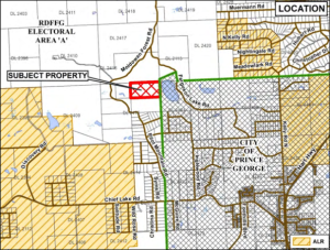
Within the four years of the current Application for Development being submitted, the subject property was clear cut. Insufficient regard was given for the riparian areas of two streams that drain the property into Ferguson Lake. Also, a significant portion of the land within the Lakeshore Development Permit Area was cleared without permission.
The following documents provide additional details.
The rezoning application was subject to a public hearing. Prior to the hearing, members of the public submitted 32 letters opposing the rezoning. After hearing concerns raised by members of the public, the initial public hearing was adjourned to give the applicant time to respond to the concerns.
This zoning amendment is worth considering in a broader context. For the subject property, there are important questions about whether the location is appropriate for higher-density residential development. To answer this question, consider (a) the suitability of the subject property; and (b) the suitability of the area to accommodate higher-density residential development. The following is a summary of RDFFG’s argument to support the rezoning and a summary of concerns raised by members of the public who opposed the rezoning. RDFFG’s position is represented in the planning staff report (Report for Consideration, Oct. 6, 2020) submitted to the RDFFG Board of Directors, which was included in the package of information available for the public hearing.
Staff position: Report for Consideration
Concerns raised by members of public opposed to the rezoning
In addition to the land use policies of RDFFG, a critical issue relates to consistency with the Regional District’s policies and the City of Prince George. The Salmon River-Lakes OCP requires integration with other planning areas, including the City of Prince George. Policy 2.2 of the Salmon River-Lakes OCP states:
2.2.0 As this plan includes part of the greater Prince George Area the objectives for land use relationships between this Plan, the City and other adjacent planning areas are as follows.
2.2.1 To not promote development proposals that would negatively impact adjacent planning areas.
2.2.2 To advise neighbouring jurisdictions of development proposals that are in close proximity for their information and comment.
2.2.3 To coordinate land use development that is adjacent to neighbouring jurisdictions such that it complements current and future land uses on either side of the jurisdictional boundary.
For this reason, when considering the amendment to rezone the RDFFG zoning by-law, one must also assess the suitability of increased rural subdivision in the urban fringe in relation to the City of Prince George OCP (By-law 8383, 2011).
In response to the expressed concerns of the public, the applicant submitted a revised conceptual design for a Bare Lot Strata with 13 lots (2 to 2.5 acres) with shared wells and an engineered water treatment facility. (With a shared water treatment facility, individual lots can be smaller than the required minimum lot size.) The public hearing was reconvened and the motion to rezone the property was approved.
On January, 20, 2022, the RDFFG Board of Directors passed the zoning amendment. During the Board meeting, the Board accepted the applicant’s offer to commit voluntarily to a no-build covenant to help protect the lower 10.12 hectares (25 acres) of the property adjacent to Ferguson Lake. To this point in the process, only the rezoning from Rural 1 (Ru1) to Rural Residential 2 (RR2) has changed; the conceptual designs of subdivision are for illustrative purposes only and were not formally considered as part of the zoning amendment. Accordingly, the conceptual design is subject to review and approval during a future subdivision process.
Primary
Regional District of Fraser-Fort George
Salmon River-Lakes OCP (By-law 1587, 1996)
RDFFG Zoning By-law (By-law 2892, 2014)
City of Prince George
Cariboo Regional District
Quesnel Fringe Area OCP (By-law 4844, 2014)
Williams Lake and Area Fringe OCP (By-law 4782, 2013)
RDFFG: Official Community Plans
The RDFFG has seven electoral areas with eight OCPs:
The RDFFG has one Rural Land Use Bylaw (RLUB):
RDFFG: Zoning By-laws
For most of the RDFFG electoral areas, a single zoning bylaw applies:
Within Area C, Punchaw Lake, a separate zoning bylaw applies:
Within Area H, a separate zoning bylaw applies to the proposed area of the Valemount Glacier Destination development:
6
URBAN PLANNING CASE STUDY
Llewellyn, J. (1999). Understanding a city’s form and function: The development and planning history of Prince George (Master’s thesis).
This thesis presents a comprehensive history of planning and development in Prince George from approximately 1900-90, with a specific focus on built form. In addition, the final chapter provides critical insight into contemporary planning challenges facing the city. Available at UNBC Library.
City of Prince George.Official Community Plan Bylaw No. 8383, 2012.
City of Prince George. Zoning Bylaw Bylaw No. 7850, 2007.
Development incentive programs – website
Development incentive programs – brochure
City of Prince George. Revitalization Tax Exemption Bylaw, Bylaw 8370, 2011. (Consolidated, April 9, 2020)
Scouten, K. R. (2019). City of Prince George Downtown Incentive Program Review: Final Report. KRSolutions.
Neilson-Welch Consulting Inc. & Leftside Partners Inc. (2010). Revitalization Tax Exemption Program Downtown Prince George. In The City of Prince George.
This report, commissioned by the City of Prince George, provides background information concerning past development efforts, current constraints and information on the Revitalization Tax Exemption Program (RTE) itself. The report’s findings, which were considered unfavourable by Mayor and Council, conclude that the RTE program would be insufficient to attract new investment in downtown Prince George, although it may aid in redevelopment of existing buildings. [Report available from author.]
Regional District of Fraser-Fort George
Guide for rural subdivision in RDFFG
The following Government of British Columbia webpages provide general information about local governments, land use planning, and regulatory tools to support growth management.
Official Community Plans (OCPs)
II
7
RURAL PLANNING CASE STUDY
The Rural Planning Case Study centres on the Bulkley Valley in the Regional District of Bulkley-Nechako. This case describes the historical development of the area as influenced by provincial resource development priorities. The application is about a proposal for a driveway to access a rural subdivision.
The Bulkley Valley case introduces learners to unique challenges of rural planning where Crown lands are highly valued for both their natural resources and recreational amenities. The Bulkley Valley has been shaped through three eras of provincial resource policy. From a land use perspective, one outcome is a landscape of overlapping jurisdictions with existing and potential conflicts. The case has specific regard for what is known as ‘interface’ planning, which occurs in Crown lands immediately adjacent to townsites. These interface areas serve multiple interests and multiple uses arising from natural resource development, rural residential, recreational access, and Indigenous rights and title. The Bulkley Valley is located within the traditional territory of the Wet’suwet’en. Learners are encouraged to discuss ways in which rural land use planning can be improved.
The Smithers Community Forest Society (SCFS) appealed the province’s decision to permit a private land owner to access their property through an ecologically-sensitive area. The learner has been as a planning consultant by the SCFS to help the group to develop the strongest position to present at the hearing. The desired outcome is either refusing the application or finding an alternative route that can be supported by the Minister.
This module explains regional land use planning practice within and by the province of BC. The term “regional” describes land use planning at a large geographic scale. The need for land use planning extends far beyond urban boundaries into the remote regions where provincial parks, forestry, and mining take place. These areas also overlap almost entirely with the traditional territories of Indigenous peoples. In BC, 94% of the land base is public Crown land. Over 90% of these public lands are covered by regional land use plans.
When someone subdivides land, they are usually creating new lots from one or more parcels of land; that is, they are subdividing one parcel into multiple lots. All subdivisions in BC must be approved by an Approving Officer (AO). This module subdivision and the application and the approval process in rural areas.
The rural planning case about access to a rural subdivision raises questions about options for legal recourse that may be available to people and organisations that oppose this particular decision. This module lays out some of these options in very general terms.
The conflict between the Wet’suwet’en Nation and the Coastal GasLink pipeline has attracted national attention. This module provides a general description of the situation and highlights major sources of tension between Indigenous rights to govern land, government policies and priorities (e.g., environment versus economic development), corporate interests, and police. Content includes a description of the pipeline and of different perspectives of the pipeline, including TC Energy, Wet’suwet’en Hereditary Chiefs, and First Nations of the Wet’suwet’en.
This module explains the difference between Indigenous title and rights to land. Provides a summary of important Supreme Court decisions that recognise Indigenous title and rights to land.
8
RURAL PLANNING CASE STUDY
The Bulkley Valley case introduces students to unique challenges of rural planning where Crown lands are highly valued for both their natural resources and recreational amenities. The Bulkley Valley has been shaped through three eras of provincial resource policy. From a land use perspective, one outcome is a landscape of overlapping jurisdictions with existing and potential conflicts. The case has specific regard for what is known as ‘interface’ planning, which occurs in Crown lands immediately adjacent to townsites. These interface areas serve multiple interests and multiple uses arising from natural resource development, rural residential, recreational access, and Indigenous rights and title. The Bulkley Valley is located within the traditional territory of the Wet’suwet’en. Learners are encouraged to discuss ways in which rural land use planning can be improved.
Over one hundred years ago, in 1913, the Grand Trunk Pacific Railway Company announced it would be locating an important divisional point along its transcontinental railway in a swampy townsite colloquially known as Squatterville (Figure 1). After just one year, the surveyed site was transformed into a bustling town, complete with medical, educational, and financial services, and numerous business establishments. The government, private land companies, and residents promoted the area vigorously, as demonstrated by the popular slogan, “5000 population by 1915.” While the village managed to attract only 700 residents by incorporation in 1921, by most accounts the town was flourishing. Squatterville would eventually become the idyllic mountain town known as Smithers, located in the Bulkley Valley of the western central interior of British Columbia (Map 1).
The Bulkley Valley is the heart of the Hudson Bay Mountain Ranges. The Bulkley Valley is divided between the Regional District of Bulkley-Nechako and Regional District of Kitimat-Stikine, and is home to several rural settlements.
| Name | Population | % Change (2016-21) | |
| Town of Smithers | 5,378 | -0.4 | |
| Village of Telkwa | 1,474 | 11.1 | |
| Village of Hazelton | 257 | -17.9 | |
| District of New Hazelton | 602 | 3.8 | |
| District of Houston | 3,052 | 2.0 |
Many of the Valley’s 16,000 inhabitants are located outside incorporated areas.
Source: Canada Census 2021
Figure 1. Early settler development, Smithers, BC, 1915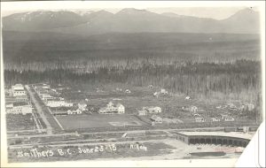
Map 1. Bulkley Valley, British Columbia.
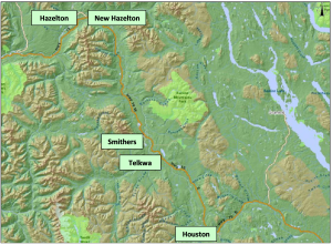
The expansion of the railway through the Bulkley Valley was part of British Columbia’s first era of resource policy that aimed to develop the resources of northern BC’s Crown lands. Smithers and the rest of the Bulkley Valley eventually developed through three eras of provincial resource policy, each of which is described as part of this case. After discussing the economic development of the region’s natural resources, this case highlights four recent planning initiatives undertaken as responses to its historical pattern of resource development. These recent initiatives include localised resource planning, planning for local economic development, access planning, and bioregional planning.
The Town of Smithers was built on lands within the unceded traditional territory of the Wetʼsuwetʼen (yintah). Map 2 shows the traditional territory of the Wet’suwet’en and areas of each clan.
The peoples of the Wet’suwet’en are the original inhabitants of the Bulkley Valley. Wetʼsuwetʼen means “people of the Wa Dzun Kwuh River” (Morris and Bulkley rivers). They have occupied 22,000 km2 of traditional territory in north central interior BC since time immemorial. First contact with European fur traders is estimated to have occurred sometime in the early nineteenth century.
The Wet’suwet’en employ a hereditary governance system to guide land management on their traditional territories. This traditional governance system is based on the following five clans, which comprise thirteen house groups:
The Hereditary Chief of each house is granted the responsibility for sustaining a specific tract of house territory, based upon matrilineal inheritance of the land. The Wet’suwet’en Hereditary Chiefs are also the governing authority for the Office of the Wet’suwet’en, the central agency that provides services for the entirety of the Nation, including land and resource management.
Map 2. Traditional territory of the Wet’suwet’en and areas of each Clan
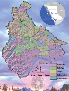
Six First Nations, established by and operating under the Indian Act, govern Reserve lands within the traditional territory. The six nations are Witset First Nation, Hagwilget Village Council, Nee Tahi Buhn Band, Skin Tyee Nation, Ts’il Kaz Koh, and Wet’suwet’en First Nation.
The early settler economy of the Bulkley Valley can be described as entrepreneurial. An entrepreneurial economy features “locally based entrepreneurs (miners, fishers, or loggers), small-scale operations, employees who may become entrepreneurs, strong local linkages, and commitment to local development.” The early period of settlement was particularly prosperous for the mining industry, with widespread exploration being conducted throughout the valley. While the most lucrative deposits were invariably financed by American companies, smaller-scale exploration activities allowed local prospectors to develop deposits that were deemed unprofitable at a larger scale.
While subsistence farming was present on the landscape prior to the arrival of the railway, the allocation of 9,700 ha of agricultural lands as “settlement area” helped to transform local agriculture into a burgeoning resource industry, with valley residents soon shipping upwards of 1,000 tons of high quality grain and forage crops on an annual basis to the newly constructed grain elevator in Prince Rupert. Many of these farmers supplemented their incomes by harvesting timber on their lands for use as railway ties, another mainstay of the Bulkley Valley’s early economy. By mid-decade there were hundreds of independent sawmill operations whose raw products were often purchased, processed, and shipped by local buyers in the Smithers area.
In addition to the early development of mining, forestry, and agriculture in the Valley, Smithers was selected as one of several sites for the installation of military airstrips. These activities, in combination with the area’s burgeoning retail and hospitality sectors, made Smithers an obvious choice for government and social services that served the region.
Overall, despite growth falling well short of most expectations, the entrepreneurial economy helped valley residents shoulder its early burdens through “innovative, self-directed change,” which helped lay a foundation for greater diversification.
By the middle of the twentieth century, the entrepreneurial economy of BC’s hinterlands was showing its limits. Although demand from national and international markets increased, the resource sectors in BC were unable to respond because they “lacked scale, secondary, and support industries, and contributed relatively little to provincial coffers.” The situation started to change following the election of W.A.C. Bennett’s Social Credit party in 1952. In conjunction with similar changes at the national level, the new provincial government initiated a comprehensive strategy for “scaling up” economic expansion that focussed on two goals:
province building, by aggressively opening up BC’s hinterland resource base to multi-national corporations (MNCs); and
community building, through active investment into resource hinterlands so as to ensure “social and economic returns long into the future.
As described by Young and Matthews, the Bennett government employed several strategies to achieve these goals, deftly balancing laissez-faire economics with interventionist policy to usher in an era of unprecedented growth. Each one of these strategies affected the Bulkley Valley.
First, the Province opened the central, northwest, and northeast regions to industrial resource development by investing heavily in transportation infrastructure throughout the hinterlands. For the Bulkley Valley, this investment in infrastructure resulted in the conversion of the old military airport in Smithers into a regional airport, as well as the construction of a highway extension connecting the Valley to Prince Rupert. Second, the government expressly encouraged consolidation of forestry operations. For example, by prioritising long-term leases when granting forest tenure on Crown lands, the government policies favoured larger firms that were better positioned to take advantage of these leases. As a result, many of the independent operators throughout the Valley either failed to have their permits renewed or had their timber quota purchased by larger companies.
The negative effect of consolidating forestry operations was somewhat softened by a package of policies that linked economic growth and social development. These included (1) appurtenancy, whereby logging and milling operations must occur within the same region; (2) utilisation requirements, which ensured a variety of tree species be harvested; and (3) minimum annual harvests, which aimed at providing rural areas with an economic base independent of market conditions. Collectively, these policies aimed to capture and retain some benefits of the hinterlands within the hinterlands.
The dual mandate of linking economic growth with social development is most evident in legislative amendments that were collectively known as the “Instant Towns Act.” These amendments allowed corporations to pre–emptively purchase and incorporate remote tracts of land for the purpose of installing “planned communities” for resource industry workers. Kitimat, Chetwynd, Fraser Lake, Mackenzie, and Tumbler Ridge are all examples of this policy.
Undoubtedly, the Bennett government was successful at achieving its goal of economic expansion through improved access to resource hinterlands. From 1940-75, provincial employment in the forestry industry tripled while employment in the mining industry doubled. In Smithers, residents “experience[d] a period of growth not seen since the original town site construction.” These achievements were largely abetted by a post-war population boom occurring throughout the province (Chart 1), as well as across the nation and the United States.
Chart 1. Population and Annual Average Growth (%) in Smithers and British Columbia (1931-2021)
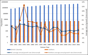
Despite the many economic benefits, resource policy during this period was not without criticism. It was suggested that the Bennett administration’s insistence on prioritising unprocessed commodity goods severely undermined rural economic diversification, a feature that persists to this day. Furthermore, this era was marred by a flagrant disregard of non-market values, and in particular, of Indigenous rights and environmental interests. This indifference is perhaps best illustrated by the 1963-68 construction of the W.A.C. Bennett Dam, an enormous hydroelectric power station designed to provide affordable electricity to BC residents and, in particular, the Greater Vancouver area. The resulting Williston Reservoir, now the largest water body in BC, had, and continues to have, a traumatising impact on the Indigenous peoples of the Peace and Finlay River Valleys. As part of the Province’s relocation effort, entire Indigenous villages were set ablaze while corpses were brusquely exhumed and dumped into mass graves. As described in a 2007 report:
…[T]he [Bennett] dam flooded not only a 168 acre reserve but [also] 640 square miles of productive Tse Keh Nay traditional territory. The old settlement of Fort Grahame ceased to be. Villages, sacred sites, hunting grounds, and trap lines were flooded and it was the end of hunting, fishing, trapping, and life as they knew it.
After the reservoir was filled, it is not known how much wildlife drowned during the spring flooding, though estimated losses are substantial.
The coalition of government, multi-national corporations, and labour unions proved a robust partnership during the Bennett era that fostered the dramatic growth in natural resource extraction. However, by the mid-1970s, several factors forged a new era of resource policy. These factors included a provincial recession, a contentious US-Canada softwood lumber debate, increasing globalisation of world commodity markets, and pressure from various opposition/advocacy groups.
The post-Bennett era of resource policy continued to promote reliance on northern BC as a “resource bank” to support industrial and technological growth in core metropolitan regions. It can also be described as an era of downloading and deregulation. If the Bennett “model for development involved the hand-in-hand expansion of rural industry and community, the foremost aim of the…[new] strategy is to disaggregate these.” In the pursuit of flexible modes of production, resource industries were increasingly relieved of their corporate social responsibilities, specifically those relating to social development. Thus, this era may be described as a “plantation model,” where resource exploitation is
…by foreign-owned [corporations], capital intensive, and while labor is well paid (in relation to local standards), job tasks are highly specialized and designed to extract a resource for use in the parent company’s operations elsewhere. The business linkages of the plantation model (value-added, services, equipment, profit flows) are primarily international rather than local….
The general direction of the post-Bennett era policy can be described using three guiding principles:
By 2003, a new era of provincial policies for Crown lands was fully formed. The Forestry Revitalization Plan (2003) abolished the appurtenance policies that were designed to link extractive industries with regional economies, ostensibly for serving as disincentives to forestry operations. The Forest and Range Practices Act instituted “results-based” objectives that allowed industry to develop forest management plans and practices without public oversight, thereby decreasing regulation pertaining to environmental values. Also, whereas provincial regulators were previously granted exclusive authority for administering forest tenure, forestry operators were now able to subdivide, trade, or transfer lease rights without ministerial approval. The BC Heartland Economic Strategy introduced legislation to streamline administration and stimulate investment in mining. This legislation provided mineral prospectors with unobstructed right of entry to 85% of the provincial land base for exploratory activities. As Premier Campbell stated, the desired effect of this strategy was to “open up the heartland of our province” and “to make sure the [rural and northern] communities that built this province share fully in the opportunities and prosperity in British Columbia’s future.”
This era of Crown land planning had several unintended consequences for the Bulkley Valley. Corporate investment shifted out of the hinterlands to larger urban centres, resulting in many layoffs and mill closures throughout northern BC. The downsizing of ministerial responsibility eliminated several service offices throughout the hinterland, including the Forest Service’s regional headquarters office in Smithers. To compensate for this withdrawal, rural municipalities were increasingly encouraged to apply for government funding framed as “community development initiatives.” Examples of these initiatives included Northern Development Initiative Trust, Community Forest Programs, and Rural Development Initiative.
Land use planning in the Bulkley Valley has been described as “a rough quiltwork; sometimes there are comfy layers upon layers and sometimes there are disturbing gaps.” This quiltwork is due to the multitude of government agencies asserting jurisdiction throughout the valley overlaid by Indigenous rights and titles. This quiltwork includes the following:
In addition, private tenure holders (forestry, mining, recreation) are responsible for developing plans at a variety of spatial scales which may or may not require public participation for plan approval. Finally, there exists a multitude of non-government organisations that directly and indirectly contribute to the planning dialogue occurring throughout the Valley.
Map 3 illustrates an example of three overlapping jurisdictions. These include the traditional territory of the Wet’suwet’en, the geo-political boundary of the Regional District of Bulkley-Nechako, and the boundary of the provincial Bulkley Land and Resource Management Plan (Bulkley LRMP).
Map 3. Overlapping jurisdictions
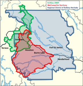
The difficulty of overlapping jurisdictions is described in Box 1. This text is an excerpt from the introduction of the government publication A Practical Guide to Effective Coordination of Resource Tenures, which helps readers understand how and why multiple tenures can exist in the same land base, and to help people take steps to avoid disputes that can arise under these circumstances. These steps include recognising a balance of responsibility among all tenure holders while also understanding the limitations of the tenures. Learning about the relevant legislation and regulations is essential.
Excerpt from Introduction (p. 6)
The Province of British Columbia, through various ministries and agencies, issues leases, licences, SRW (statutory rights of way), and permits (all commonly referred to as: tenures) for commercial use of natural resources. In all regions of the Province it is not uncommon for several tenures to apply over the same area of land. The Province adheres to a policy of integrated resource use, whereby several activities may occur on the same land base, provided they are coordinated and meet the requirements for long‐term sustainable management and are consistent with BC Government goals.
The pattern of tenures existing over a particular area of land can become very complicated due to a number of factors, including:
The Province makes every effort to ensure that resource management is coordinated, and that tenured activities will not negatively impact public interests or other rights.
Tenures are written to be very specific about the rights or privileges they convey.
There is an expectation that tenure holders where applicable will make reasonable efforts to accommodate the interests of other resource users. Reciprocal accommodation is the foundation of successful, integrated resource use.
Source: Government of British Columbia (2008). A Practical Guide to Effective Coordination of Resource Tenures.
Among these overlapping jurisdictions, the potential for conflict is significant and real. Regional-scale development of provincial and national interests do not always align with local interests, and conflicts over pipelines have brought Indigenous rights and title to national attention. A series of critically important court decisions have recognised not only Indigenous rights and title but have also worked toward establishing legal obligations for prior and informed consent through meaningful consultation.
It is amidst the “quiltwork” of land use planning policies with which we describe planning initiatives aiming to assert greater influence over Crown land use decisions in the Bulkley Valley. At this local scale, land use conflicts can be especially pronounced in the “interface” zone–the ill-defined transition zone of Crown land surrounding municipalities. Some of the present concerns in the Bulkley Valley that are related to these interface lands reflect the interests of resource towns and incorporate a broader range of resource values (recreation, aesthetic, spiritual, etc.) into management practices. he Office of the Wet’suwet’en and residents of the Bulkley Valley are among those striving to assert greater local control over Crown lands. In particular, the Wet’suwet’en continue to assert their traditional title and rights over Crown land. As well, the Bulkley Valley Community Resources Board (BVCRB) helped create the Bulkley LRMP.
McCreary’s report on the “shared histories” of Witsuwït’en-settler relations describes a historical process of appropriation and exclusion in the Bulkley Valley. McCreary describes the following conditions of colonial displacement:
If some Witsuwït’en families occupied the Smithers area prior to settlement, others came to Smithers because of colonial policies. While provincial land policies created opportunities for settlers to claim the land, it limited First Nations people who were both denied title and refused the right to claim land like the settlers. Instead, First Nations space was bounded to a set of small reserves. While numerous Witsuwït’en families sought to homestead land, they struggled to achieve legal recognition by settler authorities. Many families were forced from their homesteads. Some moved to newly created reserves while others came to town poor and dispossessed.
To counter oppression and dispossession, the Wet’suwet’en have taken an assertive approach towards improving local control over resource decisions through a variety of means, including litigation, planning, and grassroots action. Perhaps most significantly, the Wet’suwet’en and Gitxsan First Nations won a landmark case in the Supreme Court of Canada, known as the Delgamuukw decision, which established oral history as evidentiary proof of Indigenous title and rights. Moreover, the ruling provided a broader interpretation of asserted rights that defines rights in relation to “all things pre-contact.”
The precedent established by Delgamuukw was instrumental in the Office of the Wet’suwet’en’s opposition to a controversial coal-bed methane proposal near Telkwa in 2006. Wet’suwet’en Hereditary Chiefs assumed a leadership role in a valley-wide grassroots campaign to obstruct the unwanted development, most visibly through a press conference at Norwest Corporation’s headquarters in Calgary, AB, as well as a well-attended ‘Rally for the Valley’ protest in Smithers. Following their successes in the Bulkley Valley, the Wet’suwet’en Hereditary Chiefs passed a First Nations Summit resolution that called for a 10-year moratorium on all coal-bed methane development within BC.
The Office of the Wet’suwet’en was also the chief agency responsible for developing the Wet’suwet’en Territorial Stewardship Plan, a “decision-making tool based on the vision of the Hereditary Chiefs and clan membership…designed to develop a comprehensive spatially linked database of Wet’suwet’en cultural and ecological information and values at the House territory level.” As Rick Budhwa explains, the plan captures and translates Wet’suwet’en oral history, and other media of information transfer, into a GIS database that aggregates data into a “significance scale” of low, moderate, or high value. The specific criteria for determining significance are unique to each house territory. While limited financial resources had not allowed for input of ecological data, cultural values embedded in the plan were used for archaeological assessments conducted on Wet’suwet’en territory and informed the Morice River Management Plan. The Wet’suwet’en circumvented government agencies and offered the plan directly to resource industries, allowing for (1) earlier consultation with the Wet’suwet’en in development assessments, and (2) culturally-sensitive regulation of Wet’suwet’en lands. Moreover, as Budhwa explains, joint consultation agreements between the Wet’suwet’en and local firms created opportunities for economic development and capacity building with each investigation.
The on-going conflict over the Coastal GasLink Pipeline, which is designed to cross 190 kilometres of the Wetʼsuwetʼen territory, has highlighted the critical need to understand relations among band councils, hereditary chiefs, and different levels of Canadian government.
In February, 2020, the Office of the Wet’suwet’en and the governments of Canada and British Columbia signed a Memorandum of Understanding (MOU) that affirmed the following:
Work to implement the MOU continues among all three governments.
Throughout the post-war era, the BC ministry responsible for forests exercised unparalleled authority in managing forestry practices over 94% of the provincial landmass, while also determining the appropriate level of public involvement in planning. Meanwhile, area residents became increasingly vocal about their dissatisfaction with the lack of public input. In the Bulkley Valley, local unrest came to a head in 1990 when the Bulkley Forest Service announced that it would be developing a 20-year Forest Lands Management Plan for the Bulkley Timber Supply Area. Fearing that such a plan would be completed without meaningful public input, Valley residents sought to reclaim their forests. The first step was to form a regional steering committee to deal with the Forest Service office.
With the aid of a facilitator, members of the steering committee and the Forest Service negotiated the terms for public involvement during the planning process. The most important element of these terms was an agreement to form the Bulkley Valley Community Resources Board (BVCRB). Open selection of BVCRB members was based upon a candidate’s qualifications in representing one of 16 perspectives (e.g., “values timber production above other uses,” “values the maintenance of large tracts of wilderness”). This selection process was said to increase representativeness while avoiding the adversarial interactions sometimes fostered by sectoral or interest-group representation.
The establishment of the BVCRB loosely coincided with the inauguration of a new provincial government, whose election promises included the development of a province-wide, comprehensive land use planning process that would incorporate explicit requirements for public participation. This provincial resource planning policy direction was consistent with the sentiments of many Bulkley Valley residents who believed that “when it comes time to make decisions…everyone should have the right to be an expert. Value judgments should be made by those representing the community perspective, not a technical agency.”
Through various outreach campaigns, the BVCRB generated significant public support from Bulkley Valley residents, forcing ministerial agencies to surrender considerable influence throughout the process. Most importantly, the BVCRB became the primary agency responsible for drafting the Bulkley LRMP using a consensus-based process for making decisions. An Interagency Planning Team (IPT), composed of government representatives, was organised to work alongside the BVCRB in providing technical and administrative support. The BVCRB and the IPT were divided into subcommittees in order to develop four distinct land use management scenarios for public review. Attendees of the scenario workshops were asked to identify particular components of each scenario that satisfied their particular land use vision for the Bulkley Timber Supply Area. Based on this information, the BVCRB was tasked with negotiating consensus on management direction for each landscape unit, eventually culminating in the draft Bulkley LRMP. The document was presented to the IPT, the public, and the provincial government, who eventually ratified the plan with only minor revisions.
Since approval of the Bulkley LRMP in 1998, the BVCRB has maintained an active role in implementing, monitoring, and amending the plan, while also devoting resources to other management projects, including the 2005 Bulkley Valley Sustainable Resource Management Plan (SRMP). While government enthusiasm for LRMPs waned over time, the BVCRB remains an important agency for ensuring land use decisions made in the Bulkley Valley adhere to objectives established in the Bulkley LRMP. By promoting and adhering to principles of transparency, accountability, representativeness, and consensus, organisers were able to acquire sufficient public support and to transform this support into decision-making power at various planning tables.
The need to co-ordinate access to Crown land for recreational purposes is a long-standing issue in the Bulkley Valley. There are currently around 400,000 to 550,000 km of resource roads in BC and a seemingly unknowable number of backcountry paths and trails, which exist with little regulatory oversight and no comprehensive inventory concerning their number, location, and status. In areas of high recreational value, such as the Bulkley Valley, this lack of regulatory oversight may compromise opportunities to promote recreational tourism, encourage land use conflict between resource users (e.g., motorised versus non-motorised recreation), and lead to increased environmental degradation and habitat fragmentation.
During the creation of the Bulkley LRMP, the establishment of a Recreational Access Management Plan (RAMP) was a chief priority for the planning table. The negotiations were said to be weighed heavily in favour of motorised users, since ATVers and snowmobilers may directly impede non-motorised activities but are relatively unaffected by skiing, hiking, etc. Notwithstanding such differences, consensus was achieved on zoning designations (e.g., summer or winter, motorised or non-motorised) for the majority of backcountry destinations. However, a lack of a dispute resolution protocol led to three highly contested backcountry areas being designated as “unresolved.” Since the adoption of the Bulkley LRMP, user conflicts in these areas have resulted in five formal complaints to the Forest Practices Board. Through its responses, the Forest Practices Board has continuously advocated for a completed recreational access management plan in the Bulkley Valley.
In the post-Bennett era, government funding and staff resources for projects such as the Bulkley Valley RAMP are almost non-existent. Thus, it is only through the perseverance of concerned citizens that the RAMP was completed. Informal agreements resolved disputes in two of the three contested areas; although, predictably, enforcement continues to be an issue. In the absence of an access plan, provincial authorities have relied almost exclusively upon voluntary compliance. And problems continue to exist, even in areas with designated zoning. As a result of the continued efforts of Valley residents, the BC government hired a consultant to draft a process proposal for establishing consensus on summer and winter use access plans. In 2013, the BVCRB adopted a Summer Recreation Access Management Plan. No winter plan has been developed.
The planning department for the Regional District of Bulkley-Nechako deals primarily with land use and development in areas of human settlement. The planning department prepares and implements plans, policies, and regulations to guide community development in the public interest. The Regional District’s planning does not include planning for the use of Crown lands with regards to areas of provincial jurisdiction (forestry, mining, recreation, etc.) or other issues addressed through the LRMP process. However, there are select circumstances where the Regional District may become involved in issues relating to Crown land. Examples are as follows:
9
RURAL PLANNING CASE STUDY
On July 14, 2008, the Integrated Land Management Bureau (ILMB)1 received an application for a temporary permit to construct an access road to private land. The map submitted as part of the application indicates a road right of way starting from Hudson Bay Mountain Road and running approximately 1 km NE above Seymour Ridge (Map 1). Subsequently, the application was revised to avoid sensitive ecological areas (Map 2). The ILMB considered public comments prior to making its decision. On March 5, 2010, the ILMB issued its Reason for Decision on the proposed Seymour Ridge road. The Smithers Community Forest Society (SCFS) opposed the ILMB’s decision and submitted a Notice of Objection under s. 63 (1) of the Land Act2. The Minister decided that the objection warranted a hearing, as per s. 63 (2) of the Act.3
You have been hired as a planning consultant by the SCFS. Your task is to advise the group to develop the strongest position to present at the hearing with the hope of either refusing the application or finding an alternative route that can be supported by the Minister.
Your report is to be presented in two parts:
(i) If you believe that additional consultation is required in order to build your argument, outline steps required to complete the consultation process. Identify:
a. With whom will the SCFS consult; provide a rationale for including each one (e.g., interests, rights);
b. Steps required. If any decisions are to be made as part of the process you recommend then, as appropriate, explain how decisions will be made (e.g., vote by simple or super majority, a form of consensus, other);
c. Summarise your process in a table; include a timeline indicating the length of time required to complete each step. [Max. 300-400 words, plus table (the table does not count toward total words.)]
(ii) If you believe that no additional consultation is required then provide a rationale that substantiates your decision. Consider the consultations that have been completed and the information that is available from all sources.
Note: You are not being hired to identify an actual alternative route or its technical requirements.
Map 1. Seymour Ridge Access Road – initial proposal

Purpose: Transportation/Roadway
Location: Hudson Bay Mountain Road, Smithers
Area: 1.0 hectare
BCGS Mapsheet: 93L075
Legal Description: Unreserved right of way over unsurveyed and in the vicinity of Hudson Bay Mountain, Range 5, Coast District, containing 1.0 hectares, more or less.
Map 2. Seymour Ridge Access Road – revised
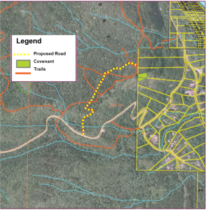
Application by Elmore Contracting Ltd. for a Temporary Permit for Driveway Construction (ILMB File 6405671 – Reason for Decision)
This document provides an accounting of the factors I have considered and the rationale I have employed as delegated statutory decision maker in making my decision, under Section 11 of the Land Act, on the application by Elmore Contracting Ltd. (Conan and Kathy Petursson) for a driveway. These factors have all been considered, as described in this document, prior to my decision of March 2, 2010.
Conan and Kathy Petursson, as individuals and as principles in Elmore Contracting Ltd. (herein referred to as the applicants) own Lots 6, 7 and 8 of District Lot 2518, Range 5 Coast District (the properties). The application relevant to this decision was submitted to the Integrated Land Management Bureau (ILMB) in June 2008. The application was for construction of a driveway to access the upper bench of the properties. The properties are fronted by the Hudson Bay Mountain Road at the toe of the slope. Geotechnical stability issues on the lower properties preclude the applicants’ ability to construct a residence and associated access from the Hudson Bay Mountain Road.
The proposed driveway is located within the area of the Wetzin’Kwa Community Forest Agreement, awarded to the Wetzin’Kwa Community Forest Corporation (WCFC) in 2007. WCFC has the exclusive right to harvest timber within their Agreement area. The mission statement of the WCFC is to “manage a profitable community forest tenure while providing good forest management stewardship that will sustain forest resource values for future generations”. Within WCFC’s tenure is an area designated in the Bulkley Land & Resource Management Plan (LRMP) as the Smithers Community Forest Special Management Zone 2 (SMZ2). The management emphasis for this zone is to provide community recreation and education in a demonstration forest. The Smithers Community Forest SMZ2 contains a network of recreation trails used for Nordic skiing, hiking and public education. The driveway crosses the Seymour Ridge Trail and three additional trails that connect to it.
In addition to the Smithers Community Forest SMZ2, the driveway is within a Core Ecosystem of the Bulkley LRMP and Bulkley Valley Sustainable Resource Management Plan (BVSRMP). The objectives for core ecosystems were established as Objectives Set by Government in September, 2006. The purpose of the core ecosystems is to provide a representative cross-section of naturally occurring ecosystems, to maintain biodiversity by providing interior forest conditions, and to maintain biodiversity by retaining representative examples of rare and endangered plant communities in core ecosystems.
In making my decision, I have weighed the complexity of the social, environmental and economic factors associated with the application. In doing so, I have considered the file history, relevant land use planning direction including objectives set by Government resulting from the Bulkley LRMP, any information or comment provided by referral agencies, the public and First Nations, and the needs of the applicant. On March 2, 2010 the application for a driveway to access the properties in question was approved under Section 11 of the Land Act. This tenure became effective on March 5, 2010. As part of the tenure approval, the following conditions apply:
The driveway will be built to the minimum level required for residential & occasional heavier truck traffic (ie to get building materials to the site). It will not be built to industrial standards.
Running width to be kept to a minimum (3-4 metres) except on curves, switchbacks and turnouts where a wider running width will be required.
Clearing width to be kept to the bare minimum to allow for driveway construction and ditch integrity (1-3 metres either side of road prism where possible)
Access along the driveway will not be restricted, except as required to allow for subgrade set-up.
Signage will be installed prior to construction informing the public of the construction and closing the trails to use within a safe distance. Placement of the signs will be determined jointly with the District Recreation Officer, Ministry of Tourism Culture & the Arts.
The Integrated Land Management Bureau and Ministry of Tourism Culture & the Arts will be provided with a minimum of one week’s notice prior to commencement of driveway construction.
Barriers and filters will be used to deter motorized use of the hiking trails.
Three similar, but different, applications have been previously submitted to access the same properties. Two were submitted in 1994 and 1995 and one by the current applicants in 2005. All of these applications were disallowed. The decision to disallow the 1994 application was made based on the assumption that there was existing access from the Hudson Bay Mountain Road and on the recommendation of the Smithers Community Forest Steering Committee that the driveway could potentially impact future recreational opportunities. In addition, concerns were raised by Ministry of Environment regarding the importance of the open slope areas for wildlife habitat. Subsequent to the 1994 disallowance, the applicant at the time was advised by the Ministry of Transportation that due to slope instability and sight distance limitations it was not possible to construct a driveway or residential infrastructure using access from the Hudson Bay Mountain Road. The same applicant reapplied in 1995. Referral responses covered the same set of issues as that received for the first application. The application was again disallowed on the recommendation of the Smithers Community Forest Steering Committee that the driveway could potentially impact future recreational opportunities., No discussion occurred on how the slope stability issues were considered in the decision.
In the case of the 2005 application, the Smithers Community Forest Steering Committee (SCFSC) recommended disallowance due to impacts to values and use of the community forest, specifically impacts to the trail, wildlife habitat, and sensitive ecosystems. In their response the SCFSC cited the existence of road access from the Hudson Bay Mountain Road and a concern that the approval of the driveway could lead to further residential development in the area. At the time, the SCFSC was responsible for ensuring forest management activities in the community forest were consistent with the LRMP objectives, and ILMB decision makers deferred to the recommendations of the committee. As a result, the application was disallowed.
Many comments have stated that the disallowance of the previous three applications should dictate that the current application be disallowed. In addition, concerns have been raised regarding the precedence approval of this application would set for future applications in the Core Ecosystem and Smithers Community Forest SMZ2. My role as an independent decision maker is not to validate or repeal previous decisions. Past decisions certainly informed my review. However, my determination making authority is founded on the legal and policy framework and state of the landbase at the time of decision. The management regime and organizational responsibilities for the Smithers Community Forest and associated recreational values have changed in the time since the past three applications were reviewed. Similarly, any future applications of this nature will be subject to the same level of discretion on the part of the decision maker. The approval of this application does not legally bind future decision makers to approve any or all similar applications in the vicinity. I am satisfied that I have considered the relevant information from past decisions in my determination.
Public advertising of Land Act applications is at the discretion of the Integrated Land Management Bureau. The application was advertised in the Interior News on July 23 and 30, 2008. A significant amount of comment was received and has been considered in my decision as outlined below. As a result of agency and public responses received, the driveway location was altered to mitigate concerns raised. The application was not re-advertized when the revised driveway location was proposed. I considered whether the revised driveway location was of a significant difference that would result in new or different concerns being brought forward. The driveway location was not any closer to private residences and the issues of impacts to recreation, wildlife and ecosystem values remained the same, with the exception of the removal of the direct overlap with the red listed ecosystem. I therefore am satisfied that the public consultation process was adequate to identify the range of concerns with the application.
All four applications have been referred to First Nations. No responses have been received as a result of consultation efforts. A review of available information has not revealed significant indicators of a potential infringement of aboriginal rights and/or title. The driveway will be non-exclusive in nature and impacts to resources important to First Nations will be low. Accordingly, I am satisfied that the Province’s legal duty to consult has been met.
In considering social needs, I have assessed whether the application was a suitable use of Crown Land. The applicants do not have suitable access to their private land. The initial location of the Hudson Bay Mountain Road resulted in destabilization of the lower slope of the applicants’ properties where they front the road. Subsequent re-ditching of the road has resulted in increased undercutting of the road, further reducing the associated slope stability. A representative of the Ministry of Transportation and Infrastructure (MoTI) informed the applicants that any construction of a house and associated sewerage and access improvements had a high potential to further destabilize the slope, resulting in a failure. A potential failure of this nature would likely destroy the associated portion of the Hudson Bay Mountain Road, resulting in significant reconstruction costs and public safety issues, as well as liabilities which would be assumed by the applicants. In addition, the interruption in use of the road would have a significant impact on the residents, recreational users and commercial and industrial operators for whom the Hudson Bay Mountain Road is the only access.
Development of the properties adjacent to Hudson Bay Mountain Road poses risks to infrastructure, economic development and public safety. By disallowing the application I would be denying the opportunity for the applicants to develop their property in a manner that does not carry these risks. The result would be a landowner whose only options are to not develop the properties or to develop the lower properties and assume the associated risk. As a decision maker I must consider both the implications of approving an application and the implications of disallowing an application. I have determined that the application is valid and has a strong justification, and I am not prepared to put a private individual in a position where a choice that is subsequently his to make may result in a significant risk to public safety.
Approval of the application provides minimal economic benefit to the Province. Numerous concerns were raised through the public consultation process regarding the applicants’ future use of the property that would provide the applicants with economic gain, such as harvesting of timber, increased property value, and development of a large commercial operation. I do not have the jurisdiction or mandate to evaluate or consider these concerns. I must review the application based on the merits of the application itself, as outlined above. I therefore did not consider future potential economic gain to the applicants in my decision.
Approved Land Use Plans inform decision makers on the social, environmental and economic balance of values within plan areas. The driveway application is within the planning areas of both the Bulkley Land and Resource Management Plan (BLRMP) and Bulkley Valley Sustainable Resource Management Plan (SRMP). The BLRMP provides planning direction to the BVSRMP, therefore the two plans need to be reviewed in harmony.
Two specific resource management zones identified in both plans provide direction for my review of this application: Special Management Zone 2, Unit 10-4 (Smithers Community Forest); and Core Ecosystem. The BLRMP objective for the Smithers Community Forest SMZ2 is to provide community recreation and education in a demonstration forest. Any plan for this area must follow the Smithers Community Forest Steering Committee Plan. Prior to the award of the Community Forest
Agreement to WCFC in 2007, the Smithers Community Forest Steering Committee was responsible for forest management planning within the Smithers Community Forest SMZ2. With the award of the Wetzin’Kwa Community Forest Agreement in 2007, the Wetzin’Kwa Community Forest Corporation (WCFC) has replaced the Steering Committee as the party responsible for management planning within the Smithers Community Forest SMZ2. However, the core values of the SMZ2 remain the same, with a focus on recreation and education while allowing for industrial operations. The Community Forest Steering Committee evolved to become the Smithers Community Forest Society (SCFS), continuing to promote opportunities for recreation, education, and forest management demonstration within the Smithers Community Forest SMZ2, but relinquishing some of its responsibilities for overall forest management.
The BLRMP does not provide a specific objective for Core Ecosystems however the identified purpose is to protect values by providing representation of a cross-section of ecosystems, by retaining representative samples of old growth forests, and by providing forest-interior conditions. The BVSRMP objective for Core Ecosystems is to maintain over time the following:
The direction and strategies for both the Core Ecosystem and Smithers Community Forest SMZ2 focus mainly on forest management and timber extraction. The direction does, however, identify priority values which must be considered during other activities. An application (Lands File 6406529) for a residential roadway within both the Core Ecosystem and the Smithers Community Forest SMZ2 was approved in 2005. While the ecological and recreational issues vary greatly between that application and the current one, the recent approval does serve to inform decision makers that residential access is not specifically excluded from these areas. A significant amount of comment on the current application suggests that timber harvesting conditions should be applied to all uses on Crown land. Land use planning direction for resource management zones often places restrictions only on certain types of activities. It is therefore not appropriate for me to draw a direct link from one activity to all activities. Specifically, the strategies in the BVSRMP state that within Core Ecosystems, if harvesting does occur, no permanent road access structures can be built. As described by the Ministry of Forests and Range (MoFR) in their referral response, the driveway is not a “management” activity as it is not related to a commercial operation on Crown land and therefore is not specifically excluded.
Specific Land Use Objectives arising from the plans were established under the Land Act in 2000 and 2006. While established under the Land Act, the Land Use Objectives do not have a direct legal application to Land Act decisions. I am satisfied that the driveway is consistent with the policy direction contained within the Bulkley LRMP and Bulkley Valley SRMP. In making my decision I have considered the values of the core ecosystem and the Smithers Community Forest SMZ2 and how the driveway would impact those values. Those values and my considerations relevant to them are further described in the sections below.
The driveway location as applied for in June 2008 crossed a red listed ecosystem (SBS dk 81, Saskatoon – Slender Wheatgrass). This ecosystem is associated with the open, southwest facing slopes prevalent along the ridge. ILMB mapped the ecosystem relative to the application area and, along with the applicant and an ILMB employee who has significant experience with grasslands ecosystems, conducted a field inspection to confirm the presence of the rare ecosystem and determine if there were possibilities for mitigating the impacts. As a result of the field visit it was determined that the driveway could be moved away from the open slopes and back onto the flat bench at the top, thereby completely avoiding the rare and endangered ecosystem. The approved driveway location reflects this change and I am therefore satisfied that impacts to the red listed ecosystem have been avoided.
Broad concerns have been raised regarding the impact of the driveway on wildlife habitat and ecosystem values associated with the Seymour Ridge area. Referral responses from the Ministry of Environment (MoE) in 1994 and 1995 had referenced the value of the open slope areas. By moving the driveway away from the red listed ecosystems, the open slope areas were not impacted. I advised MoE staff of this and they advised that the relocated driveway was in an area that still contained high habitat values. I had an extensive discussion with MoE staff to solicit more detailed information on the specific habitat values at risk, possible mitigation strategies and a description of the impact of the driveway in the context of the surrounding landscape and allowable uses. I was advised that the ridge crest forest adjacent to the red listed ecosystem provides “snow interception, thermal and screening cover as well as a continuum of forage species”. These values were identified as being captured by the Core Ecosystem designation in the BLRMP and therefore subject to the direction contained in the plan. MoE’s recommendation was that a coordinated approach to access, including roads and recreational trails, needed to be taken within the Smithers Community Forest SMZ2 and that the application should be held in abeyance until such a time as this coordinated planning process could be completed. As a decision maker I must consider all the information available to me at the time of application. An absence of detailed operational plans is not sufficient reason for me to defer a decision, particularly when such plans are not in progress at the time of application.
In making my decision, I have considered the impact of the driveway in the context of the availability and state of the habitat values across the surrounding landscape. To date the majority of disturbance to this landscape has been small patch timber harvesting, small-profile logging roads, hiking trails and cross country ski trails, most of which have been concentrated to the west of the driveway area. The driveway construction as proposed involves minimizing the removal of timber by building to driveway, not industrial, road standards and weaving around mature timber as much as possible. I have also considered the other allowable uses in the vicinity and their potential impacts to habitat values. I have considered whether the construction of the driveway to this standard will result in an unacceptable cumulative impact to habitat values. I am satisfied that the driveway, constructed as per the tenure conditions, will not have significant negative impact on either the habitat values of the surrounding forest type or on ecosystem representation across the core ecosystem area landscape.
The impact to the Seymour Ridge trail network was the most prevalent concern brought forward by the public. Subsequent to acceptance of the application the Smithers Community Forest Society applied to the Ministry of Tourism, Culture and the Arts (MTCA) to have the SCF trails designated as Recreation Trails. The trails received official designation under Section 56 of the Forest and Range Practices Act (FRPA) on August 18, 2009. The driveway location as applied for in June 2008 made several trail crossings and also ran between the Seymour Ridge trail and the edge of the ridge, where the views from the trail are the most significant. The revised driveway location is now away from the edge of the ridge on the west side of the trail, and crosses the Seymour Ridge trail twice. One crossing is near the beginning of the trail, well back of the ridge, and the second is where the trail enters the applicants’ property. The first crossing of the Seymour Ridge trail is the more significant of the crossings. The second crossing occurs at the mapped trail location but not the used trail location. The used trail is actually on the applicants’ private land, over which MTCA has no jurisdiction. As a result, where the used trail passes through private land, the mapped trail for designation follow the outside of property line. In addition to the Seymour Ridge trail, the driveway crosses two branches of the Goldeneye trail and, where the Seymour Ridge trail reaches the applicant’s private land, the driveway crosses a short trail (Sackungen trail). The Seymour Ridge trail is the more heavily used trail of the network, with the Goldeneye trail experiencing a moderate to low level of usage and the Sackungen trail experiencing low levels of use.
There is no question that the driveway will alter the current state of the trail network. The Ministry of Tourism, Culture and the Arts (MTCA) is responsible for the authorization and management of recreation facilities and trails on Crown land under the Forest and Range Practices Act. The review of this application was made with the direct involvement of the District Recreation Officer (RO) for MTCA. I invited the RO to attend the above-mentioned field visit to discuss impacts and possible options for mitigation. Moving the trail back to the approved location has increased opportunities for utilizing natural filters to minimize the amount of driveway directly adjacent to the trail. Due to the location of the trails and the applicants’ properties it is not possible to further reduce trail crossings. Increased risk of unauthorized motorized use of the trail as a result of trail crossings has been brought up in public comment received. I note that the Seymour ridge trail is accessible to motorized vehicles at its commencement point on the Hudson Bay Mountain road. It does not appear that there is currently any unauthorized motorized use of the trail. To mitigate this risk, however, I will require the placement of barriers at trail crossings to discourage such use. As a result of the field visit and discussions regarding mitigation strategies, MTCA recommended approval of the application subject to a number of conditions, as outlined in Section3 – Decision above. I have evaluated the potential impacts to the recreation trails and weighed those impacts relative to the merits of the application. I have determined that the revised location of the driveway is a suitable location and I am satisfied that the construction conditions agreed to by the applicant, ILMB and MTCA are adequate to protect the overall recreational value of the Seymour Ridge Trail network.
As described in Section 2 – Background, the driveway is located within the Wetzin’Kwa Community Forest Corporation’s Community Forest Agreement area, within which WCFC has the exclusive right to harvest timber. WCFC has a Memorandum of Understanding (MoU) with the Smithers Community Forest Society (SCFS) regarding forest harvesting and recreation activities within the Smithers Community Forest SMZ2. The SCFS has stated that WCFC verbally indicated to them that logging would not occur within the Core Ecosystem area of the SMZ2. WCFC has responded stating that WCFC recognizes and understands the constraints of the core ecosystem but have made no commitment to forego all harvesting opportunities within it. The MOU states that any required access within the area covered by the agreement would be done in such a manner as to minimize trail crossings. The MOU also reinforces that maintaining access for WCFC to their entire tenure area is critical to their operations. WCFC has expressed their support for the application so long as their use of the driveway is not restricted and with the recommendation that trail crossings be minimized as much as possible. While the driveway will not be constructed to an industrial standard, access along it will not be restricted. I am therefore satisfied that my decision will not unduly restrict the ability of WCFC to operate in the future should such operations be proposed.
After weighing and assessing all of the public and agency referral comment as described above, I am satisfied that my determination to grant the land act tenure for driveway construction, with conditions attached, represents an appropriate and fair balance of the social, environmental and economic concerns expressed. I am also satisfied that my determination takes into account and fairly considers the balance of public values as expressed through the Bulkley LRMP and subsequent associated legal and policy documents.
Notice of Objection under Section 63 (1) of the Province of British Columbia Land Act – related to application for a temporary permit for a “driveway” (the “Seymour Ridge Road”)
1. Although the status of this application is posted as “offered” on the ILMB Website, the disposition is not yet complete due to the requirement that an Occupant Licence to Cut be issued by the District Manager, Ministry of Forests and Range, Smithers. See s. 8(3) and s. 8(4) of the Land Act (the “Act”). The Licence to Cut has not yet been issued.
2. The Reason for Decision posted on the ILMB web site states that an offer has been made subject to any terms and conditions that need to be met before the tenure is issued. There is no indication that any or all of these terms and conditions have yet been met.
3. In the Decision Rationale posted on the ILMB web site, the application is described as a Temporary Permit, suggesting a permit under s.14(1)(c) of the Act, yet the ILMB decision maker states that the decision is being made under s.11 of the Act. The application cannot be considered complete for the purposes of s. 63(1) until the decision-maker unequivocally informs the applicant and the public under which provision of the Act she is exercising her jurisdiction.
4. The “driveway” is being proposed through a Core Ecosystem of the Bulkley Land and Resource Management Plan (LRMP) and the Bulkley Valley Sustainable Resource Management Plan (BVSRMP) – the purpose of which is to provide a representative cross-section of naturally occurring ecosystems, to maintain biodiversity by providing interior forest conditions, and to maintain biodiversity by retaining representative examples of rare and endangered plant communities in core ecosystems. Specifically, the strategies in the BVSRMP state that within core ecosystems, if harvesting does occur, no permanent road access structures can be built. Although the decision maker states in her rationale that the driveway is not a “management activity” and thus it should not be specifically excluded, this is a technicality that completely ignores and contravenes the meaning and intent of the Core Ecosystem designation resulting from a long established and extensive public planning process. Though referred to as a “driveway” in the application, the rationale states that public access will not be restricted. The term “driveway” is commonly used to describe a private access way falling completely on private land. What is actually being approved in this case is a “road” that will provide public vehicle access into a significant portion of the Core Ecosystem – a Core Ecosystem which has already been impacted elsewhere by road access.
5. In the consideration of this application by the decision maker, considerable weight is given to slope stability concerns where a public road, Hudson Bay Mountain Road, is adjacent to the lots for which access is sought, yet the decision-maker provides no references to any technical or professional reports to substantiate any slope stability concerns along that existing road which allegedly prevent the applicant from accessing his property from there. As well, there is no reference to any technical reports to substantiate the overriding assumption that the Seymour Ridge road access provides any less slope stability risk than the Hudson Bay Mountain Road access. So far, our attempts to obtain any relevant reports that were used in the decision have failed.
6. Further, the decision-maker does not appear to have considered any slope-stability and other access matters raised by the approving officer under s. 73 of the Land Title Act when the lots that the “driveway” purports to access were originally subdivided. Under the Land Title Act, land cannot be sub-divided until, among other things, the sub-divider can provide each lot with legal access to a public road. In the present application, the decision-maker should have considered why that originally approved access is now said to be unavailable.
7. The decision maker states in her decision rationale that the three previous applications for a similar road were turned down largely on the advice of the Smithers Community Forest Steering Committee (now called the Smithers Community Forest Society). This committee is designated in the Bulkley LRMP as the body that coordinates management activities within the Smithers Community Forest – where this and the previous applications occur. For the past 22 years, this body has been actively involved in the coordination of recreation, forest management, and ecosystem interpretation initiatives in the Smithers Community Forest. The decision maker goes on to state that since the Wetzin’kwa Community Forest tenure was awarded for this same area in 2007, the role of the Smithers Community Forest Committee (now the Society) has largely been taken over by the Wetzin’kwa Community Forest Corporation (WCFC). This is incorrect in that the current Memorandum of Understanding between the Society and the WCFC clearly outlines the significant role the Society continues to play in management recommendations within the Recreation Emphasis Zone where the proposed road is located. Had the decision maker properly understood this relationship between these two bodies, she would have been obliged to give greater weight to the recommendations against approval of the application put forth by the Smithers Community Forest Society. The rationale states that the WCFC supported the application. At a recent public meeting, however, the Manager of the WCFC emphasized that their position on the road was neutral – neither for nor against.
8. The Ministry of Environment (MoE) submitted referral responses for this and previous applications for roads on Seymour Ridge that strongly recommended against approval – due to environmental sensitivity, risks to wildlife habitat values, and incompatibility with the management direction provided by the LRMP. In fact they recommended that s.17 (Conditional Withdrawal) of the Land Act be explored for the area in order to reflect the LRMP management/planning direction. The decision maker in her rationale describes the advice of MoE in some detail but in the end this advice appears to have little bearing on her decision. If there is disagreement between these two government agencies on the merits of this application/approval, then an internal mechanism to resolve this dispute must be implemented.
9. The Bulkley Valley Community Resources Board (CRB), the body responsible for overseeing the implementation of the Bulkley LRMP, also submitted a referral letter recommending against approval of this road through the Core Ecosystem. There is no mention of this significant and very relevant referral advice in the rationale of the decision maker, and thus no indication that this advice was even considered by the decision maker.
The Smithers Community Forest Society thus objects to Application 6405671 and the process by which it is being considered for approval by the ILMB decision maker. We request a formal hearing and an independent review of the decision and the rationale for this application.
“As there is already good road access to this property from H.Bay Mt. road, there is no reasonable need for a second access. My second reason is that crown land with historic use by recreational hikers and bikers should not be compromised for a private road that is not needed by the applicant.”
“Something that the public may not be aware of is that the covenanted area, shown in green on the map, is proposed by the road applicant. This was to address public concern relating to endangered grassland. (Most of which is on private property.) Concerning the ‘already good access to this property,’ it is impossible to build a road to the top, which is the only usable area, from the bottom of the property due to slope instability and grade.”
“I feel the impact on the trail and those who use it will be negative. Crown lands should not be compromised for use of the private individual.”
“What about the fact that a driveway would actually open up opportunities for those people that are not able to access the view and unique features now? (Which by the way, is on our PRIVATE property as are some of the trails.) (Physically challenged, daycare groups, the elderly, etc.) Plus, our covenant on the red-listed grassland ecosystem on our private property should be worth something as far as ‘compromising’ Crown land. People should research what is really going on here and not just blindly trust those who supposedly know, yet are not letting all the facts be known.
10
RURAL PLANNING CASE STUDY
Land Use Plans & Legal Direction By Region (LRMP, SRMP)
Bulkley Land and Resource Management Plan (LRMP) (home page)
Bulkley LRMP [PDF]
Bulkley LRMP Higher Level Plan Order [PDF]
Note: some of the Legal Orders have been cancelled.
Bulkley Valley LRMP Objectives Set by Government – 2006 [PDF]
Bulkley Valley Sustainable Resource Management Plan (SRMP) [PDF]
Bulkley Recreational Access Management Plan (1997 RAMP)
Wetzin’Kwa Community Forest Corporation
Bulkley Valley Community Resources Board
Valley Vision [no longer working]
Regional District of Bulkley-Nechako
Ministry of Transportation and Infrastructure (MoTI): Planning and Designing Access to Developments Manual [PDF]
Land Act [current as of March 29, 2023]
Forest and Range Practices Act [current as of March 29, 2023]
III
11
NATURAL RESOURCES PLANNING CASE STUDY
The Natural Resources Planning Case Study covers two geographic areas. This case describes the joint environmental assessment for the Kemess North mining proposal, which concluded with a ground-breaking decision against the project. The application is about joint land use planning between the Haida Nation and the Province.
The environmental assessment of the Kemess North gold and copper mine is unique for many reasons. From a natural resource land use planning perspective, the assessment process offers important insights about how conflicts among private rights to subsurface minerals, provincial strategic land use planning, and title and rights of Indigenous Nations are addressed. In particular, the Kemess North case highlights the efforts of the Tse Keh Nay, a tripartite coalition of Indigenous Nations in northern British Columbia, to oppose the development of this mine within its traditional territories. This case includes a review of mineral tenure law in BC, for which rights to subsurface resources centre on ‘free entry’ of mining proponents. This review is followed by a history of the Kemess North development proposal, and the corresponding environmental assessment in relation to Tse Keh Nay rights and title. Students are encouraged to consider strengths and weaknesses of regional land use planning, including consultation protocols in British Columbia.
The Council of the Haida Nation and the Province of British Columbia are in a joint (government-to-government) land use planning process. The Haida Gwaii/Queen Charlotte Islands Land Use Plan Recommendations Report and Addenda (hereafter, Recommendations Report) has been completed and the two governments are working toward a final strategic land use plan. As part of this work, the Council of the Haida Nation and the Province are negotiating an agreement for the amount of lands to be designated as protected areas (PAs) and as no-mining watersheds (NMWs). To reach agreement, the two parties identified options for each tenure (PAs and NMWs). As an expert in joint land use planning, the learner has been hired as a third-party consultant to advise both parties and to recommend which options for PAs and NMWs should be adopted as part of a joint strategic land use planning agreement.
In BC, the purchase of Crown land by a private landowner usually involves the exclusive transfer of surface rights. Subsurface rights, including access to minerals, natural gas, and petroleum resources, are retained by the province for disposition to individual prospectors or corporations. This module describes important aspects of property rights related to these developments. The module covers how a person acquires subsurface rights for mining, oil and activities, mineral reserves, and coal reserves. The module also includes a critical review of BC’s “free entry” system and legal challenges of this system by Indigenous Nations to reclaim governance over mining activities.
This module explains the difference between Indigenous title and rights to land. Provides a summary of important Supreme Court decisions that recognise Indigenous title and rights to land.
This module explains regional land use planning practice within and by the province of BC. The term “regional” describes land use planning at a large geographic scale. The need for land use planning extends far beyond urban boundaries into the remote regions where provincial parks, forestry, and mining take place. These areas also overlap almost entirely with the traditional territories of Indigenous peoples. In BC, 94% of the land base is public Crown land. Over 90% of these public lands are covered by regional land use plans.
12
NATURAL RESOURCES PLANNING CASE STUDY
British Columbia (BC) boasts considerable subsurface resources, including coal, gold, copper, industrial minerals (sulphur, silica, etc.), and construction aggregates (gravel, sand, limestone, etc.). Consequently, there are major mines operating throughout the provincial land base, with hundreds of smaller aggregate and seasonal mines. According to the BC Ministry of Energy, Mines and Low Carbon Innovation (MEMLCI), the mining sector employs directly and indirectly more than 30,000 people and contributes $9.9 billion to the provincial economy. Offsetting the benefits of economic development, the exploration and extraction of these mineral resources has had profound influences on the province.
When Northgate Minerals Corporation proposed to develop the Kemess North copper/gold mine in 2003, everyone expected that this project would be approved. The first sign that the outcome might be different appeared when a joint Federal-Provincial panel review was announced in 2004. At the time, these joint reviews were the most comprehensive assessment procedures practised and, prior to Kemess North, had never before been used when conducting a mine assessment in BC. As it turned out, the panel’s recommendation was also unprecedented in BC: the project was not approved as proposed.
While Kemess North is a milestone case for recognising Indigenous interests through an assessment process and an inspirational tale of environmental justice, the case also highlights fundamental shortcomings involved in asserting Indigenous title and rights to subsurface resources on a project level. The lack of formally recognised regional land use plans that accommodate multiple interests has implications for all parties. In particular, regional land use planning, if done well, is widely considered as a potentially important, if not essential, mechanism for recognising and asserting Indigenous title and rights over traditional territories. In the absence of joint land use plans between the Province and Indigenous Nations, the joint environmental assessment panel decision applies only to the project as proposed to the panel, so the potential exists for similarly controversial development proposals—and the need to start a new review process.
Between 1998 and 2011, Northgate operated the Kemess South Mine (mineral lease # 354991). In 2001, exploration activities revealed substantial mineral deposits in an area approximately five kilometres north of the existing mine site. The bid to develop these deposits would eventually become known as the Kemess North Project.
The Kemess South mine was controversial for the communities. Blockades went up. But the lack of public support behind their opposition resulted in very cornered communities. Ultimately the mine went through.
Source: personal communication (June 20, 2010).
The Kemess North mine site is part of an area owned by Kemess Mines Ltd., a subsidiary of Northgate Minerals Corporation. The Kemess property, shown in Maps 1 and 2, covers roughly 34,000 ha in north-central BC, approximately 430 km northwest of Prince George. Large portions of the Kemess property were given to Northgate as compensation for the expropriation of the Windy Craggy mineral rights during the creation of Tatshenshini-Alsek Provincial Park. Northgate owns surface rights to the entirety of the property, as well as to two inactive mineral leases (#410732, #410741). It also has registered 206 mineral claims.
Map 1. Kemess Property Location in BC
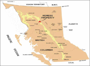
The Kemess Property and its associated mineral tenures overlap with the traditional territories of the Fort Connelly First Nation, Gitxsan House of Nii Kyap, Kwadacha First Nation, Takla Lake First Nation, and Tsay Keh Dene First Nation (hereafter the ‘Five Nations’).
Map 2. Kemess North and South Mine Locations
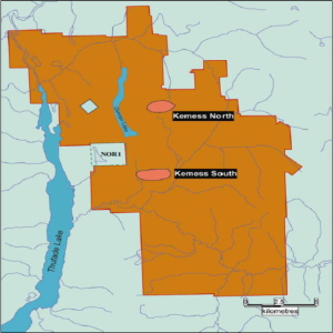
As part of province-wide regional planning (Box 1), the Mackenzie Land and Resource Management Plan (Mackenzie LRMP) was initiated in 1996 and ratified in 2000, a seemingly ideal timeframe to anticipate and resolve potential land use conflicts associated with the Kemess North mine. The Kemess Property is contained entirely within the Mackenzie LRMP. However, both the Mining Association of British Columbia and (most) Indigenous groups were notably absent from the Mackenzie LRMP process.
In 1999, industry representatives from the mining sector withdrew from the Mackenzie LRMP process after “conclud[ing] they could not achieve their goals and objectives by going through collaborative approaches.” This ambivalence is at least partially explained by section 14(5) of the Mineral Tenure Act, where “a land use designation or objective does not preclude application by a recorded holder for any form of permission, or approval of that permission, required in relation to mining activity.” Therefore, unless the Kemess property was designated as a protected area—in which case Northgate would have a strong argument against expropriation—the LRMP process has little bearing on access and exploratory rights afforded under the ‘free entry’ system. (For an Indigenous perspective on the free entry system, see Box 2 and the Learning Module on Subsurface Property Rights.) In the absence of the Mining Association, mineral interests were represented by provincial agencies at the planning table.
Learning Module
The Kwadacha was involved throughout the Mackenzie LRMP as a full table member, a designation which treats Indigenous representatives as equivalent “stakeholders” to other resource interest groups. The relegation of Indigenous interests to stakeholder status falls well short of the preferred government-to-government interactions that are advocated in contemporary planning practices. For these (and other) reasons, the Tsay Keh Dene declined participation, but did submit an independently produced Land and Resource Conservation Management Plan, which is attached as an appendix to the Mackenzie LRMP.
In relation to Kemess North, a relevant sub-area of the Mackenzie LRMP is the Thutade Resource Management Zone (RMZ). The sub-area is designated as a Mining and Wildlife Special Resource Management Zone, as follows.
The intent of this zone is to manage for the conservation of non-extractive values such as wildlife and wildlife habitat, fish and fish habitat, heritage and culture, scenic areas, recreation and tourism. This zone also has a special emphasis on mineral development and related access. Opportunities are maintained for timber, mineral and oil and gas development.
The RMZ objectives related to mineral development are to:
While the RMZ acknowledges the numerous overlapping Indigenous land claims in the Thutade area, noting that “it seems likely that [this] was an important area for cultural diffusion,” the specific traditional uses are described as “relatively undocumented.” Consequently, the RMZ contains no objectives related to preserving Indigenous values.
The general management direction for the Mackenzie LRMP declares, “nothing in this Land and Resource Management Plan is intended to create, recognize or deny any aboriginal rights” and advocates that planning occur “co-operatively with aboriginal peoples to address their rights and interests” through management strategies designed “to minimise the effects of development on First Nations traditional and historic uses.” However, the LRMP does not clarify how Indigenous objectives will be integrated into overall management strategies, implemented, or monitored. Furthermore, only Indigenous groups with established settlements within the planning boundaries were invited to participate in the LRMP process, leaving the traditional territories of many Indigenous peoples, including those impacted by Kemess North, vulnerable to land use decision-making beyond their control. It is notable that the boundaries for the Mackenzie LRMP and the Tsay Keh Dene conservation plan are not harmonised.
I’m not sure if the LRMP process respected title at all. Rights may have been partly protected, but only where a community was willing to avoid assertion of title. A land-use planning process will only function respectfully and result in consensus if the foundation of the process is grounded in recognition of title and rights. To date, few if any processes are willing to do this, as government legal-advice consistently seeks to avoid any and all recognition of aboriginal title at an operational level. This is likely for fear of handing over authority. In my opinion, what the Crown fears most is having to add more protected areas to our province, and subsequently compensate mining companies for withdrawal of tenures, and secondly, having to meaningfully collaborate at the operational level in regards to monitoring/approving future projects.
Source: personal communication (June 20, 2010).
The Tsay Keh Dene conservation plan also articulates the need for “Tsay Keh Dene involvement in determining future development and access” for mining, logging, and road construction. Although the conservation plan makes no specific mention of Amazay Lake, the plan refers to the significance of nearby Thutade Lake, where objectives related to conservation of fish and wildlife habitat are relatively consistent with the Thutade RMZ.
The consultation process for a mining project begins with a Notice of Work application. Under certain conditions, an environmental assessment is required, which establishes a comprehensive process of consultation.
Initial consultation for the Kemess North deposit began with the exploration referral process, where affected parties receive a Notice of Work (NOW) from project proponents and are granted 30 days to comment on the proposed project locations, schedules, and mitigation measures. For Indigenous groups, responding to a NOW involves the completion of a traditional-use assessment, which describes how a project will impact Indigenous rights. Many Indigenous groups, particularly in northern BC, are overwhelmed with referrals and are unable to adequately respond within the “brutal” time frame afforded. This problem is exacerbated by the generalised nature of NOW referrals, which often fail to provide the details necessary for a thorough assessment of potential project impacts. Furthermore, in the case that an Indigenous group is able to respond to a NOW within the allotted timeframe, critics argue that of Indigenous opposition to NOWs is often ignored. In the case of Kemess North, this initial consultation process did not capture the concerns of affected Nations. An extensive exploratory drilling program was conducted from 2001-04.
In 2003, Northgate officially submitted its pre-application environmental assessment proposal for Kemess North with provincial authorities. Under the Public Consultation Policy Regulations of the BC Environmental Assessment Act (2002), a proponent was required to conduct and document a “public consultation program that is acceptable to the executive director.” Despite the fact that there is no common law duty on proponents to consult with Indigenous peoples, most proponents find motivation to voluntarily consult with impacted peoples, an expensive and time-consuming task which may serve to improve public relations, exhibit corporate social responsibility, flow benefits to Indigenous peoples, or proactively resolve land use conflicts.
In 2004, Northgate and the Five Nations signed a Statement of Understanding (SOU), which in turn laid the foundation for negotiations on a Consultation and Negotiation Protocol. The protocol was designed to address compensation measures, employment contracts, revenue sharing, and impact benefit agreements. Northgate’s estimates of socio-economic benefits (Box 3) and compensations (Box 4) were included in these discussions.
Source: Kemess North Joint Review Panel [EAO] (2007).
Source: Ken Stowe, President and CEO, Northgate Minerals Corporation
Whereas the affected Nations initially supported the Kemess North proposal, chiefly because of the purported socio-economic benefits that would result from its development, they eventually mounted a full opposition to Northgate’s proposal. The disagreement stemmed from the company’s preferred method of disposal for waste acid mine tailings, which involved indefinite containment in pristine Amazay (Duncan) Lake:
Northgate Minerals is proposing to destroy Amazay (Duncan Lake) to make a waste dump for its Kemess North mine.… Amazay Lake is part of our territory and is an important place to our people. Amazay means “little mother.” We believe it is a birthing place for animals that are important to us. It is a place that we have used, managed, and protected since time immemorial.
Negotiations for the protocol agreement lasted six months, but reached an impasse when it became increasingly clear that Amazay Lake was the only option for tailings impoundment. This provision was unacceptable to the Five Nations, who signed the SOU with the explicit understanding that alternative waste disposal options would be thoroughly considered during the environmental assessment process.
While the Five Nations continued to voice their opposition, Northgate persisted in “intimating to environmental assessment regulators that it had the support of First Nations to continue to pursue the lake as an option.” Subsequently, the Consultation and Negotiation Protocol was abandoned, with the Five Nations opting instead to focus upon the constitutional obligations of the provincial and federal governments to consult. As expressed by affected Indigenous peoples,
Currently, our territory is under threat from mining, logging and other industrial activity. We do not oppose development. We need jobs, training, and revenue for our people. However, we do not support unsustainable development that destroys our lands and waters.
Whereas private corporations are not specifically required to consult with Indigenous peoples independently of the overall public review process, the Crown’s duties to consult and accommodate are firmly entrenched in common law. Current interpretations suggest that “the duty arises when the Crown has knowledge, real or constructive, of the potential existence of the Aboriginal right or title and contemplates conduct that might adversely affect it.” Accordingly, the provincial duty to consult was triggered in 2003, upon receiving Northgate’s pre-application notice; the federal duty was initiated in 2004 upon the pronouncement that Fisheries and Oceans Canada would be involved in the environmental assessment. Common law has not prescribed a process for “meaningful consultation,” thus providing the Crown considerable flexibility in fulfilling its obligations.
For Kemess North, despite repeated requests by the Five Nations to establish a formal consultation agreement with the Crown, it was decided that Indigenous interests would be primarily addressed through a joint panel environmental assessment review. Joint panel reviews are the most comprehensive assessment procedures currently practised, and, prior to Kemess North, had never before been used when conducting a mine assessment in BC. In addition, one of the three panel members was appointed by the Five Nations representatives. Nevertheless, concerns remained outstanding.
In their submission to the Kemess North Joint Review Panel, Indigenous representatives argued, “[t]he federal and provincial environmental assessment processes are not the proper processes for determining and addressing potential impacts to Aboriginal title and rights and are…unable to meaningfully engage First Nations with regard to identifying potential impacts and determining appropriate accommodation measures.” Their argument rested upon the following limitations of the joint assessment process:
In 2006, the Kwadacha, Tsay Keh Dene, and Takla Nations formed an alliance, collectively called Tse Keh Nay.
In lieu of a formalised consultation agreement with Northgate or the Crown, and seeing few remaining prospects for conserving Amazay Lake, Tse Keh Nay opted to participate in the environmental assessment under protest. From the onset, however, it became clear that the process would be decidedly unconventional. Prior to the panel review, the Tse Keh Nay were instrumental in conducting numerous public relations campaigns that helped to inform the public about the severity of the mine’s environmental impact. The opening panel hearings consisted of an elaborate pipe ceremony, complete with a poignant testimonial from Takla Chief John Allan French, the content of which was included in official transcripts of the review process only because the Tse Keh Nay insisted. At a later panel hearing, to resolve funding disparities and collate additional information, the Gitxsan successfully passed a motion to suspend panel hearings, with an extension granted at the behest of the Tse Keh Nay. Finally, during winter 2006, Tse Keh Nay representatives organised a site visit for panel members to the remote, frozen Amazay Lake, where Indigenous leaders could more tangibly communicate their cause for concern.
For their part, the panel review members also displayed a unique approach to the review process. In addition to Northgate’s 2004 feasibility study, the panel ordered two independent feasibility assessments, which would eventually conclude that the proposal was “not economically robust” and project benefits were “marginal.” The panel also chose to adopt what was coined a “sustainability assessment framework,” where panel members reviewed each of the project stages in terms of (1) environmental stewardship; (2) economic benefits and costs; (3) social and cultural benefits and costs; (4) fairness in the distribution of benefits and costs; and (5) present versus future generations.
After 11 months of contentious dispute, suspended hearings, and countless inputs of human resources, the panel reached its recommendation, as follows.
The Kemess North Mine Joint Review Panel has concluded that development of the Kemess North Copper/Gold Project in its present form would not be in the public interest .… The Panel recommends to the federal and provincial Ministers of the Environment that the Project not be approved as proposed .… Key adverse effects include the loss of a natural lake with important spiritual values for Aboriginal people, and the creation of a long-term legacy of environmental management obligations at the minesite to protect downstream water quality and public safety.
The panel’s recommendation, unprecedented in BC, was highly contested by Northgate officials, who declared that “[s]uch a conclusion does not appear to be shared by any of the federal and provincial departments who have reviewed this and many other similar projects and found the risks to be acceptable.” Northgate called the decision “a deep disappointment for the Canadian exploration and mining community.” In spite of a persuasive public relations campaign by Northgate to reject the panel’s recommendation, the provincial and federal agencies upheld the panel’s verdicts.
In March 2010, Northgate submitted a second Notice of Work proposal to continue exploration at Kemess North with the intention of developing a “smaller footprint” underground mine in the same area.
It seems to me that each and every provincial process is standing on only one leg, and is therefore sensitive to any and every land-use conflict. Current provincial land designations could easily be thrown out of court for failing to meaningfully consult and accommodate First Nations. I see the remedy for this lies in granting the right of full consent to each and every project. Will this result in some projects not moving forward? Yes. However, I would expect that many more projects would move quickly because the government and industry would have to come to the realization that they are partners in the planning and the decisions, not final arbiters.
Source: personal communication (June 20, 2010).
According to JP Laplante, the former Mining Coordinator for Takla Lake Nation, the Kemess North project underscores the need for joint land use planning between Indigenous peoples and the provincial government.
The human resources required at the community and leadership level to engage in a battle such as the Kemess North are significant. The time and energy dedicated to this battle could have been directed to other areas such as community development, education, health, housing, and other community priorities.
Laplante believes that landscape-level land use plans could minimise conflict and work toward harmonising development goals of all parties. Such agreements may include provisions for a preferred consultation protocol or policy related to mineral development. Specific policies can include land use plans that are the result of reconciling existing provincial and Indigenous land use plans or of a new joint planning exercise.
13
NATURAL RESOURCES PLANNING CASE STUDY
The Council of the Haida Nation and the Province of British Columbia are in a joint (government-to-government) land use planning process. The Haida Gwaii/Queen Charlotte Islands Land Use Plan Recommendations Report and Addenda (hereafter, Recommendations Report) has been completed and the two governments are working toward a final strategic land use plan. As part of this work, the Council of the Haida Nation and the Province are negotiating an agreement for the amount of lands to be designated as protected areas (PAs) and as no-mining watersheds (NMWs).
The PAs are defined as follows:
(i) areas where commercial forestry, mineral exploration and development, and hydro-electric development are prohibited;
(ii) areas where Haida Nation sustenance traditional and cultural uses are permitted provided that they are carried out within ecological limits; and,
(iii) areas where other permitted uses, and the levels of such permitted uses (e.g. tourism, recreation, etc.) are to be determined in a manner that respects and recognizes the primary purpose of the protected area.
The NMWs are to protect important fishing watershed areas and are established as “no mining zones” under the Mineral Tenure Act (s.22 Mineral reserves) and Coal Act (s.21 Coal land reserves).
To reach agreement, the two parties identified options for each tenure (PAs and NMWs).
As an expert in joint land use planning, you have been hired as a third-party consultant to advise both parties and to recommend which options for PAs and NMWs should be adopted as part of a joint strategic land use planning agreement.
In your professional report (not to exceed 1,000 words) you are to:
a) Present your recommendation, with rationale, for one of the three options being considered for protected areas (PAs); and,
b) Present your recommendation, with rationale, for one of the three options being considered for no-mining watershed reserves (NMWs).
In your report, you must demonstrate the following:
Although you might have a strong opinions about the options, it is the quality of your argument (and supporting evidence) that matters rather than how well you express your opinion.
Note: Time period. The case is set in April, 2006, after the Recommendations Report was prepared. The two parties are aiming to sign a strategic land use agreement in 2007.
Joint land use planning between Indigenous Nations and the Provincial Government can lead to agreements that include provisions to protect natural areas and specific policies related to mineral development. These policies can include land use plans that are the result of reconciling existing provincial and Indigenous plans or of a new joint planning exercise.
The Haida Nation has a history of joint management. In 1985, the Haida declared Gwaii Haanas a protected heritage site and, in 1993, agreed to a co-management strategy with Parks Canada. In 2010, the Haida Nation established a Marine Conservation Area Reserve that is co-managed with Fisheries and Oceans Canada.
In the initial phases of the provincial government-led Land and Resource Management Plan (LRMP) process for Haida Gwaii, the Haida Nation rejected the proposed process and, instead, insisted on a government-to-government decision-making model, where representatives of the Council of the Haida Nation would co-chair the planning process alongside the Province of British Columbia (BC). This process led to the signing of the General Protocol Agreement on Land Use Planning and Interim Measures. This protocol established measures for collaborative engagement between the two parties and an ecosystem-based management (EBM) framework to guide management strategies.
The Community Planning Forum (CPF) was the primary means to carry out discussions. The first meeting was held in September, 2003. The CPF consisted of 29 participants who represented the Haida Nation, local governments, the provincial government, non-governmental organisations, and business organisations.
An early step in the process was for the Council of the Haida Nation to develop a land use vision, the Haida Land Use Vision, which was presented to the CPF and finalised in 2005. This vision represents a balance of ecological, cultural, and economic interests. The vision was adopted by all representatives of the Planning Table except the forest industry. The Province held a neutral position.
During the creation of the Recommendations Report, which was developed through a 17-month process, a consensus-based agreement was not reached on a preferred scenario for EBM. Instead, the CPF representatives considered “viewpoints.” Votes were taken on these Viewpoints for each area element of the EBM framework. Where disagreement was more widespread, differing management recommendations are organised into opposing ‘perspectives.’ The tumultuous nature of the planning process, as described by Takeda and Røpke, involved widespread mistrust, civil disobedience, and political subterfuge. As the authors state, this level of disagreement is far from the academic tendency to “regard collaborative planning processes in terms of…an idealised win-win outcome”; close scrutiny reveals that the joint land use planning process was anything but amiable.
As of April, 2006, areas of disagreement still need to be resolved, including the extent of new protected areas and of watersheds where mining is restricted. You are required to consider these two outstanding items.
Your decision requires careful evaluation of a variety of historical, cultural, socio-economic, and environmental factors. While a comprehensive analysis of mineral reserves in Haida Gwaii is beyond the scope of your contract, some important points to consider are:
Each of the options being considered for PAs and NMWs is summarised below. First, a summary of projected impacts on mining activity is provided in Table 1.
Table 1. Summary of Impacts of Options on Mining Activity
Current Management | Post-Agreement Options | ||
PA1 and NMW1 | PA2 and NMW2 | ||
Employment Potential | No exploration or mining activity in last 20 years. | Mining activity anticipated to return due to greater land use certainty. | Reduced potential activity relative to PA1 and NMW1 |
The Council of the Haida Nation is committed to realising the PA2/NMW2 options (see below) as outlined in the Haida Land Use Vision. These two options are consistent with the Haida Land Use Vision and are strongly advocated by the Council of the Haida Nation. The Council anticipates that any deviation from this vision will result in significant litigation expenses, as well as economic losses resulting from continued land use uncertainty.
Industry representatives argue that any increase in protected areas and no-mining watershed reserves beyond current management agreements will irrevocably compromise mining viability on the island.
The two options being considered for protected areas include ‘protected area 1’ (PA1) and ‘protected area 2’ (PA2). The extent of the land base for each option is presented in Table 2. These options are consistent with Viewpoints 1 and 2, respectively.
Table 2. Protected Area Options
| Total Land base | Current Management (before the Agreement) | PA1 | PA2 | |
| Area (%) | – | 22.4 | 37.7 | 42.0 |
| Area (ha) | 1,004,764 | 225,067 | 378,796 | 422,001 |
The estimated impacts of the options on areas identified as having potential for mineral exploration are provided in Table 3. These areas are identified as having either high or very high potential for mining.
Table 3. Protected Areas Options: Impacts on Metallic Mineral Potential
Metallic Mineral Potential | Total Area | Currently Protected | PA1 | PA2 | |
High | % | – | 15.3 | 38.4 | 43.9 |
ha | 490,352 | 75,024 | 188,295 | 215,265 | |
Very High | % | – | 29.8 | 36.9 | 39.9 |
ha | 505,570 | 150,660 | 186,555 | 201,722 | |
The extent to which the land base for each protected area option overlaps with pre-existing mineral tenure is outlined in Table 4.
Table 4. Protected Areas Options: Impacts on Metallic Mineral Tenure
Existing Tenure | Total Area | Currently Protected | PA1 | PA2 |
% | – | 2.8 | 7.7 | 8.0 |
ha | 36,400 | 1019 | 2803 | 2912 |
The three options being considered for designation of important watersheds as reserves are ‘current management’, ‘no-mining watershed reserve #1’ (NMW1), and ‘no-mining watershed reserve #2’ (NMW2), as presented in Table 5. No-mining watershed reserves are consistent with the intent of restricting mineral rights through available legislation. These NMWs are in addition to the PAs.
Table 5. Watershed Reserve Options
Total Land Base | Current Management | NMW1 | NMW2 | |
Area (%) | – | 0 | 5.7 | 11.0 |
Area (ha) | 1,004,764 | 0 | 57,359 | 109,360 |
The estimated impacts of the options on areas identified as having potential for mineral exploration are provided in Table 6. These areas are identified as having either high or very high potential for mining.
Table 6. Watershed Reserve Options: Impacts on Metallic Mineral Potential
Metallic Mineral Potential | Total Area | Current Management | NMW 1 | NMW2 | |
High | % | – | 0 | 4.7 | 12.0 |
ha | 505,570 | 0 | 23,097 | 58,945 | |
Very High | % | – | 0 | 6.8 | 10.0 |
ha | 490,352 | 0 | 34,220 | 50,307 | |
The extent to which the land base for each no-mining watershed reserve option overlaps with pre-existing mineral tenure is outlined in Table 7.
Table 7. Watershed Reserve Options: Impacts on Metallic Mineral Tenure
Existing Tenure | Total Area | Current Management | NMW1 | NMW2 |
% | – | 0 | 44.4 | 44.5 |
ha | 36,400 | 0 | 16,175 | 16,183 |
14
NATURAL RESOURCES PLANNING CASE STUDY
Integrated Land Management Bureau (2003). Haida Gwaii / Queen Charlotte Islands Land Use Plan Background Report.
This report provides a background information about the social, ecological and economic characteristics of the Haida Gwaii region. It was prepared to provide information for the land use planning process.
Land Use Objectives Order: Background
Land Use Objectives Order Amendment Decision-Making Process
BC Land Use Planning for Provincial Public Land
BC Modernizing Land Use Planning
BC Land Use Plans & Legal Direction By Region
British Columbia Ministry of Energy, Mines and Low Carbon Innovation
For all BC Laws
Coal Act [SBC 2004] Ch 15
Environment and Land Use Act [RSBC 1996] Ch 117
Environmental Assessment Act [SBC 2018] Ch 51
Forest and Range Practices Act [SBC 2002] Ch 69
Forest Practices Code of British Columbia Act [RSBC 1996] Ch 159
Impact Assessment Act (S.C. 2019, Ch 28, s. 1)
Land Act [RSBC 1996] Ch 245
Land Use Objectives Regulation
Mineral Tenure Act [RSBC 1996] Ch 292
Mines Act [RSBC 1996] Ch 293
Oil and Gas Activities Act [SBC 1998] Ch 39
Petroleum and Natural Gas Act [RSBC 1996] Ch 361
Pipeline Act [RSBC 1996] Ch 364
Public Policy Consultation Regulation B.C. Reg. 373/2002
IV
15
FIRST NATIONS RESERVE PLANNING CASE STUDY
The First Nations Reserve Planning Case Study centres on the McLeod Lake Indian Band. The case provides historical context for the application, which presents options to develop one of their Reserve lands for a mix of residential and commercial uses.
This case highlights how the McLeod Lake Indian Band (MLIB) has learned to function within the property rights regime established by the Indian Act. The Band strives to maximise benefits from restricted opportunities available by choosing to operate under the Framework Agreement for First Nations Land Management. Learners are encouraged to understand and appreciate the practice of land use planning on Reserve lands that is very different from other jurisdictions in British Columbia.
The McLeod Lake Indian Band (MLIB) is considering a proposal from a non-member, off-reserve private developer to develop the McLeod Lake Indian Band Reserve land at Bear Lake. The proposal has both benefits and costs to the Band. The MLIB Land Management Committee is considering three options under which they would proceed with the residential subdivision. The Committee has hired an external consultant with expertise in First Nations Reserve land use planning, to advise them. Learners are to review the options and present a report to the Committee.
This module addresses First Nation Reserve land tenures, which encompasses Indigenous people’s rights to land only under Canadian common law. Reserve lands were created in accordance with the Indian Act. Under this Act, the use, control, and disposition of Reserve lands by Indigenous peoples are severely constrained. The issues with this state-controlled Reserve system are pronounced when compared to two other regimes that are available to First Nations, which are: (1) self-determined tenures under the Framework Agreement on First Nations Land Management (hereafter, Framework Agreement); and, (2) fee simple treaty settlement lands offered under the BC Treaty Commission Process. Collectively, the three regimes represent a continuum from limited property rights under the Indian Act to full property rights after treaty settlement.
This module explains the difference between Indigenous title and rights to land. Provides a summary of important Supreme Court decisions that recognise Indigenous title and rights to land.
16
FIRST NATIONS RESERVE PLANNING CASE STUDY
Reserve Lands are established by the Indian Act and represent an egregious colonial practice that, among many other things, removes and restricts property rights of Indigenous Peoples. In particular, First Nations and its members have limited options regarding land development and economic development. The Framework Agreement on First Nation Land Management (Framework Agreement), adopted and enacted in 1996, enables First Nations to opt out of sections of the Indian Act and to acquire planning and management rights for their Reserve lands. Full rights to manage Reserve lands can be pursued through the modern BC Treaty process. These options for First Nations represent a continuum of control over property rights on Reserve lands, thus affecting how land use planning is practised. This case highlights how the McLeod Lake Indian Band (MLIB) has learned to function within this context and, to the best of their ability, maximise benefits from restricted opportunities available by choosing to operate under the Framework Agreement. Learners are encouraged to understand and appreciate the practice of land use planning on Reserve lands that is very different from other jurisdictions in British Columbia (BC).
“We, The Tse’Khene Nation (People of the Rock), are proud people. We believe the Creator put us here as stewards of the land. We will regain our Traditions to cultivate a respected, united, self-sufficient community.”
Members of the McLeod Lake Indian Band (MLIB) are of the Tse’Khene, an extension of the Athapascan speaking peoples of northern Canada. Traditionally, Europeans refer to Tse’Khene as “Sekani.” The roughly 108,000 km2 traditional territory (as shown on Map 1 and described in Box 1) has been occupied by McLeod Lake Tse’Khene since before European contact. The main settlement of the McLeod Lake Indian Band is located on McLeod Lake, about 150 kilometres north of Prince George. Throughout its history, the McLeod Lake Tse’Khene people have remained defiant in protecting their lands and interests.
European fur traders first settled in the area in 1805 at Fort McLeod, which served as the first trading post west of the Rockies and is the oldest continuously occupied non-Indigenous settlement in BC. The opportunity to trade with Europeans at Fort McLeod enticed the traditionally nomadic Tse’Khene people to establish nearby residences. But this contact had consequences. “Exposure to disease, alcohol, firearms contributed to the systematic breakdown of almost all their laws, customs and social systems” and had profound and devastating effects on the Tse’Khene. From 1840 to 1925, the recorded population was reduced from 202 to 60.
Map 1. McLeod Lake Tse’Khene Traditional Territory
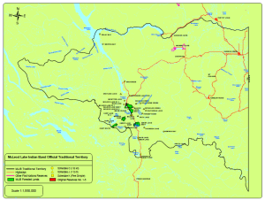
To the south, the height of land separating the Arctic and Pacific watersheds near Summit Lake. To the east, following that height of land to the border of British Columbia and Alberta. To the north, following the border to the Peace River, west, following the southern bank of the Peace River to Williston Lake, south, following the western bank of Williston Lake to the western bank of Manson Arm, south, along the west bank of Manson Arm, southwest and west, along the height of land between Manson River and Eklund Creek and Jackfish Creek, southwest. To the west, along the height of land between the Nation River watershed and the Omineca River watershed, south and east along the height of land separating the Arctic and Pacific watersheds to the commencement point.
Source: territory as described by oral history in the 2004 Land Use Plan
In 1867, through section 91(24) of The Constitution Act, 1867, the Government of Canada was granted law making power over all “Indians and Lands reserved for the Indians” to ensure the “Peace, Order and Good Government of Canada.” By these laws the McLeod Lake Tse’Khene were arranged onto five Reserves, which combined for a total land base of 244 km2. The extent of original set of McLeod Lake Indian Reserves (#1-5) are depicted in Map 2.
The erosion of the traditional territory of the McLeod Lake Tse’Khene and their culture continued throughout the twentieth century with devastating effects. The McLeod Lake Tse’Khene were subject to institutional assimilation at Lejac Indian Residential School (1930s-1976), the economic impact of closure of Fort McLeod as a trading post (1956), and the flooding of 1,761 km2 of traditional territory following the construction of the W.A.C. Bennett Dam (1969). By the 1970s, the traditional livelihood of the Tse’Khene had been compromised significantly.
Map 2. McLeod Lake Reserve Lands #1-#5
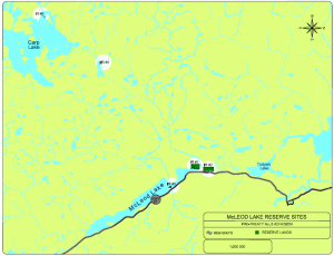
The erosion and transformation of the traditional territory of the McLeod Lake Tse’Khene took place within a process of “tenure formalisation.” (See Box 2 for a definition of tenure formalisation.) In Canada and other colonised countries (e.g., United States, New Zealand, Australia), many of the historical efforts at tenure formalisation have centred on granting a person legal title to small portions of traditional territory. According to Baxter and Trebilcock, the physical boundaries created by the reserve system serve as a means for implementing government policy with the eventual goal of ‘civilisation.’ They also characterise the Canadian reserve system as a “vestige of past attempts to promote the norms, if not the legal rights, of private ownership…while maintaining central control of tenure administration in First Nations communities.” Voluntary enfranchisement packages, which have been presented in various incarnations were offered as alternatives to the restrictive property interests afforded under the reserve system.
Baxter and Trebilcock define tenure formalisation as follows.
“Our definition seeks to characterise formalization in terms of goals to improve tenure security and transferability. In this sense, formalization captures attempts to create greater predictability by: (1) leveraging the coercive power of the state—for example, through the judiciary—to enforce land tenure regimes for rights holders against counter-claimants; and (2) harmonising the group’s land tenure regime with the regime that is already administered by the state for outsiders, potentially increasing the familiarity of the group’s system for some rights holders. It would be an oversimplification to regard formalisation merely as a process of imposing private property rights on individuals within the group; the state can recognise and enforce land tenure at various levels of governance. For example, the federal government in Canada might directly administer a tenure regime in a First Nation by granting individuals limited possessory and use rights. Alternatively, a First Nation might be vested with a sphere of protected communal rights, which the federal government enforces against outsiders, but within which the community defines the parameters of its own land tenure regime. Both of these scenarios exist to some degree under the status quo in Canada today. Finally, given autonomous and well-supported Indigenous institutions such as bureaucracies, courts, and social services, “formal” land tenure can be interpreted as a property regime that is defined and enforced by a First Nation’s own government—an arrangement that accords more closely with some First Nation peoples’ ultimate visions of self-governance. Overall, our definition of formalisation reinforces our emphasis on exploring how tenure security and transfer rights relate to development outcomes, rather than fixating on the process of formalisation itself.”
Efforts to implement tenure formalisation by Canadian governments were opposed by Indigenous peoples, who have generally regarded tenure formalisation as either inappropriate to cultural traditions or as a thinly veiled attempt at assimilation (or both). This criticism is not to suggest that Indigenous peoples are opposed to tenure reform or private land ownership. On the contrary, achieving greater stability and minimising uncertainty over lands management have been a central theme in Indigenous rights advocacy throughout the twenty-first century. However, most attempts at tenure formalisation have been imposed in a homogenised and centralised manner, lacking the “social, economic, political, geographical and historical context” necessary to create tenure regimes congruous with the traditions, practices, and capacities of the many individual nations inhabiting the land base known as Canada.
Consequently, Indigenous peoples experience the dichotomy of having cultural values tied to the land with restricted rights to access and use the land. The inability for Indigenous peoples to exercise greater authority in managing Reserve lands and the assets generated by those lands is cited frequently as a contributing factor toward many of the injustices currently occurring on Reserve lands. Some of these injustices include inadequate housing, unsafe drinking water, unemployment, drug and alcohol abuse, elevated suicide rates, and spousal abuse.
While tenure formalisation can be antithetical to Indigenous rights to land, it is also possible for Indigneous peoples to improve tenure security through the same process. The McLeod Lake Indian Band has both confronted tenure formalisation and attempted to use the process to its advantage.
During the 1980s, the McLeod Lake Indian Band engaged in several heated litigious battles with both the federal and provincial governments over unresolved land claims. The Band’s claim centred on Treaty 8, which was signed in 1899 and covered a very large area that was then part of the Northwest Territories and now part of Alberta, Yukon, and northeastern BC. The McLeod Lake Indian Band claimed that the original treaty applied to the Arctic watershed, which extended beyond the geographic “height of land” of the Rocky Mountains, which was the designated western boundary of Treaty 8.
In relation to their land claim, the Band asserted their rights to the claimed land to protect their future interests. They disrupted provincially-sanctioned forestry operations and demanded an equitable share in forestry contracts conducted on their traditional territory. In July, 1987, for example, the Band established a blockade along the gravel road to Carp and War lakes. Chief Harry Chingee explained their aim was to get the provincial government to stop logging in the area until their land claim was settled. Chief Chingee stated, “I think the biggest problem we have is that our people can’t get work. That’s why we want to get control of our resources.”
The land claims, and associated on-the-ground actions, culminated in the signing of the McLeod Lake Indian Band Treaty No. 8 Adhesion and Settlement Agreement (2000). This agreement benefitted the Tse’Khene in several ways, including the following financial and land benefits:
As shown in Map 3 (shaded areas), the adhesion agreement contributed substantially to the amount of land available to the McLeod Lake Indian Band for potential development and resource extraction. The number of Reserve lands increased from 5 to 22. The Band also purchased additional lands from the province that they own as fee simple: 43 hectares in Mackenzie Junction; 56 hectares at Summit Lake (identified as fee simple parcels on Map 1). As per the agreement, the settlement funds were deposited to a trust, with Band members having use of the income derived from the invested funds but not from the principal.
In 2003, shortly after signing the Treaty No. 8 Adhesion Agreement, the McLeod Lake Indian Band became one of the first band councils in Canada to ratify a Land Code under the Framework Agreement on First Nations Land Management, a piece of legislation that transfers federal jurisdiction over Reserve land and resource management to signatory bands. Upon ratification in 2002, the Land Code established the rules for how the Band would govern its Reserve lands.
Map 3. McLeod Lake Indian Band Post-Treaty No. 8 Reserve Lands
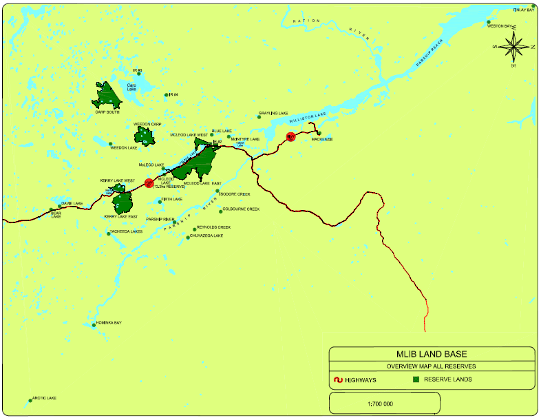
The Land Code was drafted by an appointed Land Management Committee with assistance from the national Lands Advisory Board. Highlights from the McLeod Lake Land Code are presented in Table 1. A land use plan was completed in 2004.
Table 1. Highlights of McLeod Lake Indian Band Land Code
Section | Key Points |
Preliminary Matters | The Land Code initially applies only to MLIB Reserves #1-5, with additional Treaty 8 lands made subject to the Code following an environmental audit and designation as Indian Reserves. The Land Code takes precedence over any other Band laws or bylaws which are inconsistent with the Code. The term ‘land’ applies to water bodies and all renewable and non-renewable resources. |
First Nation Legislation | Sets out the law-making powers of Band Council, including the development, conservation, protection, management, use, and possession of Band Land and all interests and licenses in relation to Band Land Examples include zoning; land use planning and development; the granting and regulation of interests, including leases, permits, easements and right-of-ways; environmental assessment; subdivision regulation; as well as parkland and heritage dedications. |
Membership Approval | Member meetings are required before passing of all land laws, including land use plans, subdivisions, environmental assessment, transfer of tenures, and rates and fee adjustments. Formal membership approval is required prior to the adoption of land use plans, long-term disposition of reserve land (over 15 years), or amendment to the Land Code. |
Protection of Land | Sets the terms for expropriation of land for Band purposes. |
Accountability | Where the potential for conflict of interest exists, council members may not take part in any vote or deliberation concerning land. |
Land Administration | Establishes a five-member Land Management Committee to assist with the development of a system for Band Land administration, make policy recommendations respecting Band Land. Creates a Band Land Register for all interests and licences in Band Land. |
Forest Resources | Ensures forestry practices on Reserve lands are conducted in accordance with Band values, as per the McLeod Lake Indian Band Forest Practices Code, which was developed as a requirement of the Treaty 8 Agreement. |
Interests and Licenses | Guarantees that any interest or license in Band Land may only be issued in accordance with the Land Code. Enables Council to grant interests and licenses in Band Land, including leases, easements and rights-of-ways, and permits to extract resources. Creates an offence of trespass for people entering or using Reserve lands without authority. Laws may be enacted enabling a Member holding Band Land to benefit from the resources in and of that land; grant subsidiary interests and licenses in that land; and transfer, devise or otherwise dispose of that land to another Member. A person who is not a Member may hold a lease, license or permit in Band Land; however, the written consent of Council must be obtained for any grant or disposition of a lease, license, or permit in Band Land to a person who is not a Member. Pre-existing tenures are recognised under the Code. |
Dispute Resolution | Established a process for the resolution of disputes through a three-person panel. Other court and civil means are also available to disputing parties. |
Other Matters | Offences under the Land Code are to be prosecuted as summary convictions. |
Adopting a Land Code is a condition for a First Nation to pass other laws related to member rights to property on Reserve lands, including taxation laws. Taxation serves as a source of internal revenue for First Nations while ensuring fairness among interests in or rights to occupy, possess, or use Reserve lands. In accordance with the Framework Agreement, the McLeod Lake Indian Band adopted the McLeod Lake Indian Band Property Assessment Law, 2017, the McLeod Lake Indian Band Property Taxation Law, 2017, the McLeod Lake Indian Band Annual Rates Law, 2018, and the McLeod Lake Indian Band Annual Expenditure Law, 2018.
In 2004, the McLeod Lake Indian Band released their statement of intent to enter a self-governance negotiation with the Province of British Columbia and the Government of Canada. Six years later, the Band had progressed to the second stage of the process, called Readiness to Negotiate. However, by policy, Canada and British Columbia will not negotiate self-government agreements outside of the BC Treaty Process. This condition placed McLeod Lake Indian Band in a dilemma. To negotiate a self-government agreement, the Band must complete the BC Treaty Process. But to participate in the BC Treaty Process the Band must “open up” its 2000 Adhesion Agreement, which could result in loss of some benefits under that agreement.
Improving living conditions, income, and employment opportunities for Indigenous peoples is closely tied to on-reserve economic development. However, sources of capital for band councils and their members to pursue economic development opportunities are limited, unaffordable, restrictive, and insufficient. Most critically, Section 89 of the Indian Act eliminates the ability of a band council or individual member to pledge real and personal property on-reserve as security for financing.
In their discussion of economic development for Indigenous peoples, Shanks highlights the importance of private interests in land. For financial institutions, land is a primary source of equity, and tenure security and land value are essential for funding a business venture. Shanks argues,
The availability of, use, tenure, and jurisdiction over land is at the heart of economic development. There exists an incredibly high level of frustration over the timeframe and processes involved in land designations and additions to reserve. Certainty of tenure is fundamental to the concept of using equity in land as a component of economic development. Efforts to clarify tenure and modernise the current system of land registration, although difficult to achieve, are necessary.
Thus, land tenure and transaction costs are strongly associated with pursuing opportunities for economic development on Reserve lands, and an important part of Indigenous sovereignty over their economy.
In their study of the economic effects of existing private property rights on Reserve lands, Aragón and Kessler found there is a positive relationship between on-reserve private property and homeownership rates, housing conditions, and band public spending. The researchers also highlight an important drawback. A positive relationship between private tenure and average income was associated with an increase in non-Indigenous population, not by improvements in Indigenous households’ income or on-reserve employment.
Some of the mixed results are attributed to the ability to designate Reserve lands for third party use, thereby generating revenue for bands through lease payments and permit fees. These revenues support band spending for the benefit of all, such as community halls and improving water systems. Thus, while individual incomes may not increase substantially, the researchers found that overall quality of life improved. The researchers conclude that, notwithstanding limitations to alleviate on-reserve poverty, enabling interests in private property has some positive effects.
In addition to protecting their title and rights to their traditional territory, the McLeod Lake Indian Band have always demonstrated an entrepreneurial spirit—a strong desire to support the quality of life of its members. While the ratification of their Land Code in 2003 was an important step to gain greater control over their opportunities for economic development, the McLeod Lake Indian Band already had a history of successful entrepreneurship. For example, during the 1980s, the Tse’Khene disrupted provincially-sanctioned forestry operations and demanded an equitable share in forestry contracts conducted on their traditional territory. This display of land use rights eventually led to the formation of Duz Cho Logging, a 100% owned company that is one of the biggest Indigenous-owned logging companies in Canada. Presently, the Band operates several businesses.
The entrepreneurial spirit of the McLeod Lake Indian Band is supported by the Tse’khene Community Development Corporation. This economic development agency promotes and facilitates community and economic development to secure opportunities for business development and to increase employment of Band members.
The McLeod Lake Indian Band have a wide range of agreements with the Province of British Columbia that support not only economic development, but also social and cultural development of the Indigenous Nation. These agreements include revenue sharing agreements for wind energy projects and forestry economic development, and benefits agreements for natural gas pipelines. These agreements are listed in the appendix.
The following are a list of current agreements between McLeod Lake Indian Band and the Province of British Columbia.
First Nation Clean Energy Business Fund (FNCEBF) Revenue Sharing Agreements
Forestry Agreements
LNG Agreements
Other Agreements
17
FIRST NATIONS RESERVE PLANNING CASE STUDY
The McLeod Lake Indian Band (MLIB) is considering a proposal from a non-member, off-reserve private developer to develop the McLeod Lake Indian Band Reserve land at Bear Lake. The proposal has both benefits and costs to the Band.
The MLIB Land Management Committee is considering three options under which they would proceed with the residential subdivision. The Committee has hired you, as an external consultant with expertise in First Nations Reserve land use planning, to advise them. You are to review the options and present a report to the Committee.
In your professional report (not to exceed 1,000 words) you are to:
a) Identify advantages and disadvantages of each option. Consider the extent to which each option satisfies the interests of the developer, specifically in terms of tenure security and transaction costs, such that they remain interested partners.
b) Recommend one of the three options, with a rationale for your decision. Present any conditions that you would add to your recommended option that you deem necessary to protect the Band’s interests.
Demonstrate that your analysis of the options and recommendation are consistent with the MLIB Land Code and MLIB Land Use Plan. Wherever appropriate, substantiate your views with specific references to sections of the Framework Agreement on First Nations Land Management (hereafter, Framework Agreement) and, if needed, the Indian Act.
A private developer has approached the McLeod Lake Indian Band Council about developing residential units on Bear Lake Reserve, shown in Map 1. In the MLIB Land Use Plan, the planning statement for Bear Lake is as follows:
With excellent highway frontage and close proximity to Prince George the Bear Lake reserve has great potential for residential and service/commercial developments. MLIB has signed a Municipal Servicing Agreement with the Fraser Fort George Regional District so this reserve has access to municipal water, fire protection, school services, a community hall, and garbage collection. These services make Bear Lake ideal for highway frontage commercial coupled with a residential community.
According to preliminary designs, the development can provide up to 50 new housing units.
The Band is interested in the proposal because of two short-term needs.
The MLIB Land Code includes rules and procedures for granting property interest on Reserve lands, but does not detail which tenure types will be administered and where no individual member of McLeod Lake Indian Band has claimed or been granted rights to Bear Lake reserve land, interest in the subject area is held communally. Currently, it is possible that a variety of tenures could be granted to facilitate the development of Bear Lake, with each tenure composed of different bundles of rights for the developer and the Band.
Map 1. Bear Lake Reserve: Land Use Designations
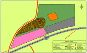
The developer, who is well versed in First Nations land tenure, has proposed three options for the Band Council to consider. All options are feasible.
The Framework Agreement allows for alienation of MLIB Reserve lands where compensation is provided in the form of other land that is to become First Nation reserve land. Other compensation may include land that will not become First Nation Reserve land. The developer has submitted a draft terms of reference, which would include compensation in the following forms:
The Band may negotiate a 99-year head lease for all or part of the Reserve lands with the developer who may then issue leaseholds (subsidiary sub-leases) to potential renters. The draft contract for a head lease involves:
A joint investment in an $9 million residential/commercial venture between the developer and the MLIB. This business venture would take the form of a corporation-to-corporation agreement between the developer and a one of MLIB’s existing corporations, with levels of ownership by each of the two parties to be determined. The joint venture would operate under a head lease with MLIB. Important stipulations include:
In addition to MLIB’s Land Code and Land Use Plan, the Framework Agreement, andIndian Act, the following resources provide relevant information.
Indian and Northern Affairs Canada (2006). Land Management Manual. Ottawa, ON: Government of Canada.
Note: this manual is for First Nations operating under the Indian Act (i.e., without a Land Code).
Starkell, Bob C. (2006). Leases on Indian Reserves. Vancouver, B.C.: Bob C. Starkell Law Corporation.
Pushor Mitchell LLP (2008). The Development Process On First Nations Lands.
Fraser, Sara Jane (2002). “Joint ventures as a sustainable development tool for First Nations,” The Journal of Aboriginal Economic Development 3(1):40-44.
18
FIRST NATIONS RESERVE PLANNING CASE STUDY
Indigenous Foundations (First Nations Studies Program, University of British Columbia)
Yellowhead Institute (Faculty of Arts at Toronto Metropolitan University)
Indigenous Land Title Initiative
Framework Agreement on First Nations Land Management
First Nations Land Management (Government of Canada)
Lands Advisory Board/First Nations Land Management Resource Centre
KPMG (2014). Framework Agreement on First Nation Land Management: Update Assessment of Socio/Economic Development Benefits.
Jobin, Shalene, and Emily Riddle (2019). The Rise of the First Nations Land Management Regime in Canada: A Critical Analysis. Yellowhead Institute.
For all Federal laws:
Constitution Act, 1867 and Constitution Act, 1982
Indian Act [RS 1985] c. I-5
Framework Agreement on First Nation Land Management Act S.C. 2022, c. 19, s. 121
Replaced:
First Nations Land Management Act [Repealed, 2022, c. 19, s. 143]
V
19
AGRICULTURAL LAND PLANNING CASE STUDY
The Agricultural Land Planning Case Study centres on protecting farmland through land use policy. This case describes the scope of farmland protection policies and factors that shape these policies. The application centres on an application to the Agricultural Land Commission to remove (exclude) farmland from the Agricultural Land Reserve.
This case explores agricultural land use planning by examining the interrelationships among provincial, regional, and municipal planning measures that influence British Columbia’s agricultural land and agricultural sector. This case is guided by over-riding questions about the public interest in protecting agricultural land to produce food for domestic consumption and export. Students are encouraged to identify trends in legislation, policy, and practices that may influence agricultural production in the future, either negatively or positively. Particular emphasis is to be paid to BC’s provincial interest in protecting agricultural lands, the role of local governments, and specific challenges and opportunities facing the agricultural sector.
As a Land Use Planner with the Agricultural Land Commission (ALC), the learner must review an application submitted by the land owner via the Cariboo Regional District to exclude 30.4 hectares from their 53.7 hectare property to create a twenty-eight lot residential subdivision. The primary source of information is the application to the ALC, along with supporting materials. The learner’s task is to complete an ALC staff report and to discuss the merits of the case. The learner must consider agricultural capability, agricultural suitability; and impact of the proposal on the agricultural sector in the area.
This module discusses factors that negatively affect BC’s agricultural lands, leading to permanent loss and alienation. Conversion of farmland refers to the change of tenure from agriculture to residential, commercial or industrial uses, most often the result of urban expansion into rural areas. This loss of farmland is considered permanent. Under the category of alienation (in the sense of separation, isolation, or dissociation), broad discussions about “loss” must also consider non-farm uses, fragmentation, parcelisation, concurrent uses, and “urban shadow” effects. Non-farm uses refer to uses of agricultural land for activities or facilities that are not directly agricultural uses. Examples of non-farm uses of agricultural land include secondary residential dwellings, commercial operations, gravel pits, churches and cemeteries, golf courses, and parks.
Protecting agricultural land is primarily a concern of land use planning by provincial and local governments. This module discusses the quality of land use policy in BC to protect agricultural land. Policy is covered by a legislative framework that defines the context and constraints for what a government can and must do. A legislative framework for agricultural land use planning includes laws, policies, regulations, codes of practice, guidelines, bylaws, strategies, plans, and governance structures. A local legislative framework includes a statutory plan as well as the related regulations, policies, and strategies that frame the plan, and extend both vertically to other levels of government and horizontally to neighboring jurisdictions.
This module discusses the quality of land use policy to protect agricultural land by each province in Canada. The module also describes the extent of agricultural land across Canada and its loss.
20
AGRICULTURAL LAND PLANNING CASE STUDY
This case explores agricultural land use planning by examining the interrelationships among provincial, regional, and municipal planning measures that influence British Columbia’s agricultural landmis and agricultural sector. This case is guided by over-riding questions about the public interest in protecting agricultural land to produce food for domestic consumption and export. Students are encouraged to identify trends in legislation, policy, and practices that may influence agricultural production in the future, either negatively or positively. Particular emphasis is to be paid to:
Is food production merely another resource-based industry equivalent to other provincial stalwarts like forestry, mining, or oil and gas? Perhaps our farms are nothing more than urban lands-in-waiting, patiently anticipating favourable market conditions to transform them into profitable residential or industrial areas. Or maybe, as some have suggested, agriculture is something entirely different—a “use of priority” where agricultural lands are protected from other uses, and farm viability is supported through economic policies and programs. The answer may be deduced by first asking, “Who needs agriculture?”
The question about the need for agriculture concerns “the nature of society we want, the place in it for farmers, the food policy we are comfortable with and the price we are willing to pay to obtain these important goals.” These needs and wants have changed during Canada’s history. The first national interests in agriculture centred on immigration and agricultural settlement as a means to increase the population of Canada’s frontier and the development of its rural economy. The direction of development changed dramatically in the 1940s. The impacts of mechanical and chemical inputs led to an intense wave of farmland abandonment in some areas and amalgamations in others. From the post-war period to the late twentieth century, agricultural policy centred on state assistance in the belief that agriculture remains an exceptional sector that provides public goods that the market alone could not achieve. The seeds of another shift in agricultural policy were planted in the 1969 Report of the Federal Task Force on Agriculture, which promoted moving away from a “public good” concept of agriculture to a focus on free enterprise and competitiveness. In 2017, the Economic Advisory Committee to the Federal Government identified the agri-food industry as a “key sector” for national economic growth with a goal to become the world’s second largest exporter of agri-foods.
The future of Canadian society will continue to be profoundly influenced by agriculture’s development and adaptation to shifting domestic and global drivers, including market volatility, urbanisation, climatic disruptions to global food supplies, and growing demand for local food and farmland amenities. At the same time, the nationally significant and localised nature of agri-food issues, whether in inner cities, peri-urban areas, or Indigenous territories, points to the need for co-ordination among and across multiple jurisdictions.
Land use planning seeks to minimise conflict in the pursuit of an appropriate balance of land uses. Therefore, it is incumbent upon practitioners and decision-makers to consider the relationship between agricultural land uses and the mosaic of competing land uses that exist across the province.
Within British Columbia (BC), and elsewhere across Canada, a historical decline in the economic and social role of agriculture during the post-war era corresponded with a significant loss and degradation of the prime agricultural land base. Prime agricultural land refers to land with high capabilities for food production. Capability is classified by the BC Land Inventory (BCLI) system, whereby Classes 1, 2, and 3 are considered “prime.” “Productive” agricultural land includes Class 4. The BCLI is based on the Canada Land Inventory (CLI) (see Box 1).
The most highly productive land base in BC faces growing pressures from urban development and the pursuit of other economic priorities, with few indications that this trend will be curtailed significantly. As well, the rights and capacities of farmers to use agricultural lands are compromised increasingly by neighbouring non-farm uses, such as when residential neighbours file unwarranted nuisance complaints about farm odours and noise, or sever residential lots near agricultural operations.
As a land use policy, protecting agricultural land first garnered serious public attention in Canada in the early 1950s with most provincial and local jurisdictions having some form of legislation or guidelines in place by the end of the 1970s. Connell et al. provide a comprehensive account of farmland protection policies across Canada. However, in spite of efforts over the past fifty years, Canada has experienced a continual loss of prime farmland.
Farmland protection policies have been accompanied by an “array of economic, environmental, and social conflicts [that] characterise the tension between urban, recreational, infrastructure, and industrial land uses, and viable rural or agricultural communities.” Correspondingly, motivations to protect farmland are influenced by factors such as food production, market value for land, environmental issues, rural landscape amenities, agrarian ideals, and land use conflicts on the urban fringe.
In addition to a desire to protect farmland, two other policy regimes influence the use and perceived value of agricultural land. A policy regime of global competitiveness has strengthened over the past fifty years at both the national and provincial levels. A recent report on competitiveness by the House of Commons Standing Committee on Agriculture and Agri-Food focussed on access to new markets, barriers to trade, food safety and product labelling, and market concentration within sectors.
More recently, a policy regime centred on food sovereignty has emerged. While the control of food supplies were among the earliest drivers of nation-building and human settlements, food sovereignty is about the right of peoples to define, protect, and regulate domestic agricultural production and land policies that promote safe, healthy, and ecologically sustainable food production that is culturally appropriate. Within BC, the growth of the local food movement, as evident by the increasing number of farmers markets and citizen-based initiatives like community gardens and local food councils, has been the forerunner of recent calls for citizens having greater control over provincial and national agri-food policies. Adopting agri-food policies that promote greater food sovereignty and household food security could easily reach into people’s daily lives, with economic, social, and environmental implications, both positive and negative.
Compared to many other provinces, BC has a small agricultural land base, equating to 4.2% of the total farmed area in Canada. Of all BC lands, the following may be described as agricultural (see Box 1):
Class 1 land either has no or only very slight limitations that restrict its use for the production of common agricultural crops.
Class 2.land has minor restrictions that require good on-going management practices or slightly restrict the range of crops, or both
Class 3 land has limitations that require moderately intensive management practices or moderately restrict the range of crops, or both.
Class 4 land has limitations that require special management practices or severely restrict the range of crops, or both.
Class 5 land has limitations that restrict its capability to producing perennial forage crops or other specially adapted crops.
Class 6 land is non-arable but is capable of producing native and or uncultivated perennial forage crops.
Class 7 land has no capability for arable or sustained natural grazing.
Source: Agricultural Land Commission
Despite these relatively modest figures, BC’s farmlands are indisputably diverse and economically valuable. The Province organises the land base into eight regions of major agricultural significance: Vancouver Island-Coast; Lower Mainland-Southwest; Thompson-Okanagan; Kootenay; Cariboo; North Coast; Nechako; and Peace Region. Currently, it is estimated that BC farmers produce roughly 200 different agricultural commodities. This food production accounts for roughly 48% of all food consumed within the province. BC’s agriculture industry generates about $4.8 billion annually in gross farm receipts and employs 23,680 farm operators.
Agricultural land can also yield many valuable ecological services, such as the provision of wildlife habitat, conservation of water and soil resources, and sensitive area protection. Moreover, many of the farmlands boast high amenity value, as evidenced by BC’s burgeoning agri-tourism industry, where consumers are increasingly enjoying direct farm marketing, orchard and winery tours, as well as low-impact recreational pursuits. Farming can also be said to have inherent heritage values, in which BC’s past and present cultural identity has been inextricably linked to the production of food.
Productive agricultural lands contribute positively toward food security. Food insecurity is a prevalent issue for BC’s proportionally large economic underclass, where 13.3% of BC children and youth (0-17) are living in poverty in 2020. While universal in its significance, food sovereignty is of particular importance to many Indigenous peoples of British Columbia. A food system largely shaped by Euro-Canadian perspectives is often to the detriment of the cultural traditions and health of Indigenous peoples. Furthermore, the agriculture industry is purported to have significant potential toward mitigation of climate change-inducing greenhouse gases, through emission reduction practices and carbon sequestration measures.
The breadth of BC’s agriculture brings with it a host of planning challenges. Agricultural land conversion, land use incompatibility, farm viability, and climate change are some of the issues to be considered when planning for agriculture.
The loss of farmland is concerned primarily with the conversion of agricultural land for non-farm uses, such as residential, commercial, or industrial uses. The availability of agricultural land is also affected by other forms of alienation, such as fragmentation and parcelisation. Other issues are alienation of farmland through foreign ownership, tree planting for carbon credits, and pressures from natural resource developments (e.g., oil and gas, forestry, mining).
Despite the idyllic images perpetuated in popular media, farm operations have significant potential for conflict with surrounding land uses. Although incompatibilities are often most visible at the agricultural-urban interface, other land use activities also negatively affect agricultural operations and vice-versa.
There are several factors that may influence the potential for agricultural land use conflict, including the type of farming operations, the intensity of farming operation, climate and topography, and perceptions. Some of the nuisances typically associated with farming operations may include:
Conversely, farm operators in close proximity to urban, commercial, or industrial land uses may be burdened by trespass, theft, livestock harassment, invasive weeds, and other damages to property.
Since the first Census of Agriculture in 1931 until 2006, BC has seen a staggering decline in farm operators. Over the past 100 years, BC has moved from 1 in 7 inhabitants living on a farm to 1 in 211. During the same period, the provincial population increased from fewer than 700,000 to over five million. While these dramatic changes can be explained partially by mass urbanisation and improved farming technologies, they are also the result of the underlying economic reality of farming: it is difficult for people to earn a living from farming.
Furthermore, gross farm receipts statistics are artificially buoyed by increasingly large inputs from government-funded payment programs. On the upside, net farm income increased since 2016.
BC’s outlook is skewed by the disproportionate influence of large-scale operators, where 10.2% of farms account for 70% of all gross farm receipts. Thus, farm viability is especially threatened for medium- and small-scale operators who are methodically being squeezed out of the market by large-scale retailers, commodity marketing boards, and inflexible provincial food inspection regulations. To supplement on-farm income, the majority of BC farmers require “off farm” income just to stay afloat.
Finally, alarm is being raised about the lack of young people entering the agricultural industry to replace the aging farmer population. In 2020, in Canada, the average age of a farmer was 56.3 years, which has increased from 49.4 in 1996, which is to say that the average farmer is getting older. At the same time, operations led by farmers aged 55 to 59 account for the largest share of all operations at 58.5%. If this trend persists, not only will our province undergo severe declines in economic activity and food production, but also considerable—and perhaps irreplaceable—loss of agricultural knowledge.
Over the past century, BC’s climate has already changed. According to Pacific Institute for Climate Solutions report, “The science to date is unequivocal”:
The same report also highlights expected changes for temperature and precipitation in BC:
Temperature
Precipitation
Climate change will have both negative and positive impacts for BC farmers. One of the chief impediments to reaping the purported benefits of climate change at a local level is irrigation infrastructure and availability of freshwater. At a global scale, changes in global food supply are certain to effect BC’s agricultural sector. Furthermore, climate change models suggest far greater uncertainty. While average temperature and precipitation regimes may favour food production, an increase in climatic variability poses substantial risks to producers. And while farmers are adept at coping with environmental hazards such as flood, drought, salination, invasive plants, pest outbreaks, and wildfires, it is expected that the frequency of such events will increase.
Reconciling competing interests for agricultural lands remains a complicated process that crosses multiple jurisdictions. Under Section 95 of Canada’s Constitution Act, 1867, responsibility for agriculture is jointly shared by the federal and provincial governments. However, responsibility for land use planning rests with provinces. Local responsibility for land use planning is the result of the provinces delegating certain areas of decision making to the local level, with varying degrees of provincial oversight.
The legislative framework for agricultural land use planning in BC is shown in Table 1. The Agricultural Land Commission (ALC) and the Ministry of Agriculture are the primary government agencies that exercise jurisdiction over farm land uses. These agencies must work in concert with a variety of federal (e.g., Canadian Food Inspection Agency), provincial (e.g., BC Farm Industry Review Board), regional, and municipal bodies, industry representatives (e.g., BC Agricultural Council, BC Cattlemen’s Association), Indigenous Nations (e.g., First Nations Agricultural Organization), and public organisations (e.g., Farmers Institutes) to effectively carry out their mandates.
Table 1. Legislative Framework for British Columbia
POLICY | LEGISLATION | GOVERNANCE | |
PROVINCIAL | Agricultural Land Commission policies Bylaw Review Guide Guide for Bylaw Development in Farming Areas (AGRI, 2015) Guide to Edge Planning | Agricultural Land Commission Act Local Government Act Farm Practices Protection Land Title Act Agricultural Land Reserve Use Regulation Agricultural Land Reserve General Regulation | Agricultural Land Commission Administrative Tribunals Act Governance Policy for the Agricultural Land Commission |
REQUIRED INTEGRATION | ALC Act s. 46(4) Conflict with Bylaws A local government bylaw or a first nation government law that is inconsistent with this Act, the regulations or an order of the commission has, to the extent of the inconsistency, no force or effect. LGA Pt. 13 s. 428(2)(e) Purpose of regional growth strategy Maintaining the integrity of a secure and productive resource base, including the agricultural land reserve LGA Pt.13 s. 475(4) consultation during development of an OCP If the development of an official community plan, or the repeal or amendment of an official community plan, might affect agricultural land, the proposing local government must consult with the Agricultural Land Commission. LGA Pt. 13 s. 477(3)(b) Adoption procedures for an OCP If the proposed official community plan applies to land in an agricultural land reserve established under the ALC Act , refer the plan to the ALC for comment | ||
REGIONAL | Regional Growth Strategy Official Community Plans Zoning Bylaws | Agricultural Land Commission (Regional Panel) | |
LOCAL | Official Community Plans Zoning Bylaws | Agricultural Advisory Committee Planning Advisory Committee | |
Perhaps no piece of provincial agricultural legislation has been more celebrated and scrutinised than the Agricultural Land Commission Act (SBC 2002 Ch. 36) (ALC Act). Originally passed in 1973 to “reflect the long-term provincial need for agricultural land,” the Act provided the legal foundation for establishing the Agricultural Land Reserve (ALR) that would be overseen by the arm’s-length Agricultural Land Commission (ALC). “The ALC Act takes precedence over but does not replace other legislation and bylaws that may apply to the land. Local and regional governments, as well as other provincial agencies, are expected to plan in accordance with the provincial policy of preserving agricultural land.” The ALC Act is recognised as a progressive piece of legislation in North America.
The strength of a legislative framework is a measure of quality. In Canada, Québec and BC have the strongest legislation. Within BC, there is a wide range of quality among local governments when it comes to protecting farmland.
The ALC Act is implemented through two regulations:
The Local Government Act (RSBC 2015 Chapter 1) (LGA) sets out the powers, duties, and functions necessary for local governments to carry out its responsibilities, including the authority to regulate the use and development of land (e.g., Official Community Plans (OCP) and Regional Growth Strategies (RGS)). Several sections of the LGA are directly relevant to agricultural planning. The LGA legislates development permit areas for the protection of farming (s488(1)(c)), which may include requirements for screening, landscaping, fencing and siting of buildings or structures, in order to provide buffering or separation of development from farming on adjoining or adjacent land (s491(6)).
The general purpose of the Land Title Act (RSBC 1996 Chapter 250) is to govern BC’s land title system and includes legislation for approving new residential subdivisions. Section 86(1) is a provision that provides approving officers the power to assess impacts of new subdivisions on farmland, whereby the approving officer can refuse an application or set conditions if the subdivision would unreasonably interfere with farming operations on adjoining or reasonably adjacent properties. The Act also governs covenants.
The Farm Practices Protection (Right to Farm) Act (RSBC 1996 Chapter 131) focusses on the relation between farming and non-farming neighbours and affirms the right of farmers to carry out normal practices without the threat of unwarranted nuisance complaints.
BC’s 4.7 million hectare ALR, shown in Map 2, is a land use designation that divides the province into two zones: agricultural lands and non-agricultural lands.
Map 2. ALR in British Columbia.
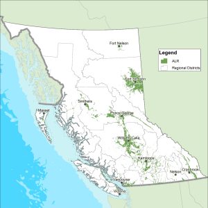
Under the ALC Act, ALR landowners must not use agricultural land for a non-farm use unless permitted by the Act or the regulations. The Act (s. 37) explicitly states that affected landowners will receive no compensation for land use restrictions, since “land is deemed not to be taken or injuriously affected by its designation as an agricultural land reserve.” Subject to certain provisions, activities designated as farm use under the ALR Use Regulation include:
In addition, the regulation outlines a number of permitted uses, which provide some flexibility for activities that are not considered to detrimentally impact future agricultural production.
The original ALR was established over a 90-day period. Each of BC’s 28 Regional Districts was made responsible for delineating reserve boundaries within their region. Boundaries were established primarily through technical analysis based on Canada Land Inventory (CLI) maps, in which agricultural potential of soils and climate are ranked into seven different categories based upon ability to produce a range of crops (Box 1, above).
The BC Land Inventory (BCLI) classification index, which is adapted from the CLI, is premised upon a mechanised production system; it does not consider “distances to markets, kind of roads, location, size of farms, type of ownership, cultural patterns, skill or resources of individual operations, and hazard of crop damage by storms” in its determination. In addition to the BCLI system of classification, there are also the Land Evaluation and Area Review (LEAR) system and the Land Suitability Rating System (LSRS), both of which take more factors into account. Neither of these other systems are used in BC.
From 1976 to 1996, the ALR underwent an extended period of fine-tuning, where boundaries were adjusted to account for: (1) imprecision in the original boundary setting process; (2) the inclusion of additional land inventory data; (3) local government planning priorities; and, (4) landowner appeal. Yet concerns about the validity of existing boundaries remain, while boundary reviews continue.
Despite many competing factors, since 1974, the total reserve area has remained consistent. In 35 years, total ALR lands have actually increased; however, “the quality of farmland in the ALR has decreased, with 2.8 hectares of prime farmland being excluded for every hectare of prime farmland included.” This trend has manifested itself in a gradual shift of ALR lands, where 90% of farmland inclusions occur in northern regions while over 70% of exclusions take place in southern environs. The vast majority of reserve lands are now located in the Province’s northern and interior farming areas.
In May, 2014, the ALC Act was amended via Bill 24. Although the mandate of the ALC was not changed, there were several major amendments that changed how agricultural land use decisions are made. The most significant of these changes was a division of the ALR into two zones. Zone 1 comprised the Island, South Coast, and Okanagan panel regions. Zone 2 included the Interior, Kootenay, and North panel regions. As stated in the Province’s announcement of the changes,
In Zone 1, where land is in greater demand and there are development and population pressures, ALC decisions will continue to be made on the basis of the original principle of preserving agricultural land. In Zone 2, where growing seasons are shorter and there are lower value crops, ALC decisions will now, in addition to the original principle, include additional considerations to provide farmers with more flexibility to support their farming operations.
In Zone 2, the ALC “must consider all of the following, in descending order of priority: (a) the purposes of the commission set out in section 6; (b) economic, cultural and social values; (c) regional and community planning objectives; (d) other prescribed considerations. Regulations to implement these changes were implemented in 2015.
The two-zone ALR was returned to a single-zone in 2019 via Bill 52, soon after a change in government. Other changes included limited new house sizes to less than 500 square metres and greater restrictions and increased penalties for dumping of construction debris, toxic waste, and other fill in the ALR. Changes were also made to regulations.
As described in Section 6 of the ALC Act, the purposes of the ALC are to:
(b) to encourage farming of land within the agricultural land reserve in collaboration with other communities of interest;
(c) to encourage local governments, first nations, the government and its agents to enable and accommodate farm use of land within the agricultural land reserve and uses compatible with agriculture in their plans, bylaws and policies.
2. The commission, to fulfill its purposes under subsection (1), must give priority to protecting and enhancing all of the following in exercising its powers and performing its duties under this Act:
(a) the size, integrity and continuity of the land base of the agricultural land reserve;
The ALC website is an excellent source of comprehensive information about its operations and policies, including the following:
Operating on the principle that the “provincial government is best able to steward the long-term food system needs of the citizens of British Columbia,” the original ALC was composed of a five member panel made up of representatives from around the province. This governance structure was thought to be consistent with the Commission’s mandate to make decisions in the provincial interest. In 2002, the Commission underwent a controversial restructuring, both in mandate and board composition. In an effort to make the Commission more “regionally responsive,” the original five member panel was abandoned in favour of six regional boards (Interior, Island, Kootenay, North, Okanagan, and South Coast), each composed of three commissioners. In the same year, the ALC adopted a three-year service plan that introduced performance measure objectives “to increase the regional responsiveness of the Commission to community needs.” Subsequently, the language of “community need” was incorporated into subsequent ALC service plans, with the 2009-10 plan stating, “The boundaries of the Agricultural Land Reserve reflect agricultural suitability, the needs of the agricultural industry and long term community needs and food requirements.” Some critics argued that this subtle shift in the Commission’s mandate resulted in an increasing number of municipalities exercising and in some cases abusing Section 13 of the ALC Act which contains provisions for facilitated dispute resolution on community issues.
Bill 15, which came into force in 2020, led to additional changes in the ALC Act. Affected areas of the ALC Act included the following: the ALC governance model (i.e., structure of the panels); more compliance and enforcement capacity and tools; new decision-making criteria to prioritize the protection and enhancement of the size, integrity, and continuity of the land base; and a requirement that applications for exclusions be submitted to the ALC only by local governments, Indigenous governments, or the Province.
In January, 2020, the Ministry of Agriculture initiated a review of its recent changes to the Act through Bill 52. The review was based on a policy direction to increase residential flexibility in the ALR. The rationale for more residential flexibility is based on several potential needs: keeping a family member (e.g., an aging parent) on the property; providing a residence for a farmer transitioning out of farming, or for a young or new person transitioning into farming; providing farmer or farm-worker accommodation, without the need to apply to the ALC; enabling a source of rental revenue.
To fulfill its mandate as set in Section 6 of the ALC Act, the ALC operates in a variety of capacities, including advising local governments on development of plans and applicable bylaws; and monitoring and auditing municipal plans and implementing bylaws for consistency with the ALC Act. However, by far the most important of the Commission’s many responsibilities is exercising decision-making authority for applications. There are several types of applications:
Application to remove land from the ALR; if approved, none of the ALC Act applies to the land. The land is subject to local government bylaws.
Application to designate land as ALR; if approved, the parcel is added to the ALR and the ALC Act applies to the land. The land is subject to local government bylaws.
An ALR parcel is divided into two or more parcels; each parcel is legally separate. The subdivided parcels remain in the ALR unless also approved via an application for exclusion. The parcels can be any combination of sizes.
Permitted residential uses of ALR land are defined by the ALC Act and its regulations. For residential uses in excess of those permitted, i.e., residential uses that do not adhere to the ALC Act and its regulations, must be approved by the ALC via application.
Literally, this refers to a use of agricultural land for non-farm purposes. Non-farm uses fall into categories of permitted and non-permitted uses. Permitted uses are defined by provincial regulations (Agricultural Land Reserve Use Regulation – 30/2019). Non-farm uses that are not permitted by regulation must be approved by the ALC via application.
A type of non-farm use. An application to remove soil from or to add material (i.e., fill) to ALR land.
A type of non-farm use. An application to use land for these specific non-farm uses: transportation (e.g., widening roads, new roads); utility (e.g., power lines, sewage treatment); and trails.
Since its formation in 1973 to 2012, the Commission processed over 35,000 applications, a task that consumes the majority of the ALC’s resources. While the furor of applications has waned since boundary refinement, the Commission still receives anywhere from 470 to 650 applications annually. About 90% of applications are made by private landowners, with the remaining percentage comprised of local and regional governments.
When the Commission reviews applications, its mandate to preserve the agricultural land reserve serves as the primary criteria for making decisions. Considerations for agricultural capability of the parcel, agricultural suitability, and impact on agriculture help to inform the Commission’s decisions.
Agricultural capability: whether the property is appropriately designated as ALR.
The effects of a change in agricultural land use would consider the agricultural capability of the soil. T he BCLI ratings are the basis for evaluating capability and would be completed usually by a professional agrologist. Related objectives are to mitigate impacts on prime agricultural areas and directing non-farm uses to agricultural land of lower capability.
Agricultural suitability. Whether the proposed land use change would affect the agricultural utility (or capability) of the property.
Agricultural suitability evaluates the proposed change in land use in relation to adjacent lands and land uses in the area. The Commission will assess external pressures on the subject parcel, including whether factors such as encroaching non-farm development have caused or will cause the land to become unsuitable for agriculture. Consideration for suitability also accounts for the history of agriculture in the area and whether subdivisions in the area are outside the ALR.
Impact on agriculture, Whether there is an agricultural benefit to the subject parcel and local area.
The Commission will consider whether the proposed land use change would negatively or positively affect existing or potential use of agricultural land in the surrounding area. For example, the Commission is reluctant to allow exclusions where there are existing agricultural land holdings and active farming or ranching is occurring.
Inevitably, land owners applying to the ALC for an exclusion or non-farm use and the ALC do not always agree on either the outcome or the criteria. Regarding the criteria, the ALC is concerned with “what is” while applicants often base their argument on “what should be.” For instance, the ALC will assess the capability of the parcel for agriculture whereas the applicant might focus on the viability of the farming operation. From the ALC’s perspective, viability is predicated on the operator’s skills and abilities, not on the capability of the soil. It is not within the mandate of the ALC to assess the former.
The portfolio of the Ministry includes responsibilities pertaining to:
The Ministry is responsible for administering the provincial Strengthening Farming Program, which “supports fair resolution of land use conflicts and effective community planning for a sustainable agriculture and aquaculture industry in British Columbia.” A tenet of this program is providing legislative support for farming activities through the Farm Practices Protection (Right to Farm) Act (RSBC 1996 Ch 131) also known as the “Right to Farm” Act. The legislation affirms that BC farmers will not be held liable for nuisances caused by agricultural activities. The organisation formed to resolve disputes under the act is the quasi-judicial Farm Industry Review Board, which determines whether or not a farmer has followed normal farm practices. The Strengthening Farming Program also provides the planning framework for integrating farming for municipal, regional, and provincial government bodies. Currently, there are three types of plans that directly or indirectly speak to agricultural land use priorities: (1) Regional Growth Strategies; (2) Official Community Plans; and, (3) Agricultural Area Plans.
BC’s unincorporated areas contain the majority (~ 95%) of ALR lands within the province. As a result, regional districts can play a significant role in co-ordinating compatible uses around existing and future farmlands. “Regional planning can also strategically address deficiencies in the links between local governments and provincial ministries and agencies, and can set in place broad regional land use objectives.”
Under Part 13 of the Local Government Act (RSBC 2015 Ch 1), a regional district may enter into an agreement with its member municipalities to enact a Regional Growth Strategy (RGS) with the “purpose of guiding decisions on growth, change and development within its regional district.” This is accomplished by planning across municipal boundaries to achieve a shared vision for a district by articulating specific goals related to social, economic, and environmental values. Once enacted, all subsequent bylaws and land use plans must be consistent with the RGS. A RGS may also benefit agricultural lands by protecting farmlands through the creation of urban containment boundaries (for an example see Map 3) and developing planning strategies to support and enhance a region’s agricultural sector. For example, the Metro Vancouver Regional Growth Strategy states a clear commitment to farmland protection as part of a comprehensive approach to planning for a regional food system. Strategy 2.3 of the RGS states, for example, “Protect the supply of agricultural land and promote agricultural viability with an emphasis on food production.” This strong statement is supported by clear commitments to urban containment boundaries. In addition, Metro Vancouver completed a regional agricultural land use inventory, a regional food system strategy, and action plan.
Map 3. Example of Urban Containment Boundary
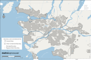
The relevance of an Official Community Plans (OCPs) to BC’s agricultural land base depends on the total area of ALR land included within a municipal boundary. Part 14 Section 473(1)(b) of the Local Government Act requires a municipality to include statements (objectives) and map designations respecting “the approximate location, amount and type of present and proposed” agricultural land uses. Farming land use designations should include all ALR lands, and may include non-ALR lands. In addition, section 474(1)(c) permits an OCP to include “policies… respecting the maintenance and enhancement of farming on land in a farming area or in an area designated for agricultural use in the plan.” Further, local governments (regional districts and municipalities) can take a more active role in agricultural planning through a variety of methods, as evident by the efforts of Metro Vancouver noted above.
OCPs may include reference to preserving contiguous agricultural areas, allowing for a wide range of farming land uses, restrictions on road construction, etc. The District of Central Saanich OCP (2023) provides an example of strong agricultural policy:
Objective: Preserve lands with potential for agricultural production. Protect these areas from incompatible and detrimental land uses, and support efforts to increase the productivity of farmlands to improve food security to support a healthy community.
Policy 1: Retain areas designated as Agriculture on Schedule F: Land Use Plan for agricultural purposes regardless of any changes that may be made by the Provincial government with respect to the Agricultural Land Reserve.
An OCP may also establish Development Permit Areas to minimise land use conflict in the agriculture-urban interface. The farming-sensitive permit areas may provide detailed development requirements including (but not limited to):
Zoning bylaws are the primary mechanism through which OCP land use designations are implemented. Zoning bylaws allow a local government to enforce specific regulations related to permitted uses, minimum lot sizes, lot coverage, etc. Under Part 14 Division 17 of the Local Government Act, a municipality may also choose to enact farm bylaws, which “allow for greater flexibility in standards for farming…matters which cannot be regulated by zoning bylaws.” Farm bylaws are local standards regulating conduct of farm operations, farm buildings, and farming materials/waste handling. However, the real merit of farming bylaws is the ability to develop different regulations depending on the size, type, and location of a farming operation.
An OCP may also identify and provide policy direction for “edge planning” areas along the agricultural-urban interface. For example, an OCP may require modified building standards for an edge planning area, such as double-paned windows for residences in order to reduce noise and odour nuisances. Roadway ordinances may suggest that no roadway endings can be pointed towards an agricultural area. Many municipalities also incorporate signage requirements in agricultural areas to increase resident awareness. However, perhaps the most widely used technique in edge planning is buffering, which incorporates a combination of separation of uses, dense vegetation, and fencing. While buffers may vary widely in type, including earth mounding, ditches, retention ponds, etc., the Ministry’s Guide to Edge Planning recommends these specifications for buffers:
An Agricultural Area Plan (AAP) is a planning tool that municipalities may use to identify issues, opportunities, and solutions related to the farming sector’s future. Essentially, AAPs “act as sub-area or neighbourhood plans of the OCP and provide a high level of detail specific to the issues relevant to farming.” AAPs are part of a logical planning hierarchy with the additional benefit of allowing for cross-jurisdictional management of agricultural lands.
Ideally, AAPs are prepared as a collaborative effort between a municipal government, the provincial government, the ALC, and most importantly, the farming sector. Members from these groups are usually organised as an AAP Working Group or Agricultural Advisory Committee. While each AAP is necessarily unique, the plans will likely include:
Another important tool available to planners and agrologists is an agricultural impact assessment (AIA). Ideally, an AIA is required when considering non-farm developments that affect agricultural land and farming or ranching activities. Relevant considerations include capability of the soil, suitability of the land for agricultural uses, negative impacts on the industry, fragmentation of the land base, minimum parcel sizes, direct development away from prime and viable agricultural lands, and mitigate negative impacts on existing or adjacent agricultural areas. Agricultural impact assessments are usually completed by a professional agrologist. The Land Evaluation and Area Review (LEAR) system and the Land Suitability Rating System (LSRS), both of which take multiple factors into account, can be incorporated into an AIA.
21
AGRICULTURAL LAND PLANNING CASE STUDY
As a Land Use Planner with the Agricultural Land Commission (ALC), you have been asked to review an application submitted by the land owner via the Cariboo Regional District to exclude 30.4 hectares from a 53.7 hectare property to create a twenty-eight lot residential subdivision. Your primary source of information is the application to the ALC (File XX398), along with supporting materials. See below for links to documents. Your task is to complete the following.
1. ALC Staff Report (length: typically, 3 pages)
Prepare a staff report for members of the ALC Interior Panel. The purpose of the report is to summarise the most relevant details to support’s the Panel’s review and decision. You are to follow a standard ALC format for these reports (use the blank template provided). Under the Comments section, include a set of brief, neutral comments you think are important for the Panel members to consider.
2. Discussion and Conclusion (1,100 words maximum)
Based on available information, you are to assess the application for exclusion using the purposes of the Commission as criteria (ALC Act s. 6). You should address whether the property is appropriately designated as ALR. You must consider each of the following as part of your discussion of the merits of the application.
– Assessment of agricultural capability;
– Assessment of agricultural suitability;
– Assessment of impact on agriculture; and,
– Assessment of other factors.
In your conclusion, briefly summarise possible reasons for supporting the exclusion and possible reasons for rejecting the exclusion. Clearly state whether you would approve or reject the application. If you support excluding the parcel, include any conditions and tools you deem necessary for the proposed exclusion. Conditions must be consistent with the Farm Practices Protection Act. Include any additional information you deem necessary.
Notes:
Submit your reports as one document (with the two parts included).
The application to rezone the subject property was made in 2008 and has been revised as if the application was submitted in 2018. All of the content of the original application is the same; only the dates have been changed. Treat this application under the current legislative framework.
Assume that the ALC has not made a decision; your report is part of that decision process. The real ALC decision is on file; do not use this to complete your assignment. You can use the application materials to complete the blank staff report template. However, avoid simply copying and pasting the information; understanding the purpose and scope of the information required to complete an ALC staff report is essential to completing the second part of the assignment.
The entire subject property (~53.4 ha) is in the Agricultural Land Reserve (ALR) and is located approximately 10 km east of 100 Mile House. An aerial photograph of the subject property is included in the application package. The landowners are requesting an ALR exclusion for the southern portion with the intention of developing a residential subdivision on the excluded property. The proposed residential properties would be comprised of 28 one-hectare lots. The remaining 23 ha would remain in the ALR.
22
AGRICULTURAL LAND PLANNING CASE STUDY
Agricultural Land Commission Act [SBC 2002] c. 36
Agricultural Land Reserve General Regulation, B.C. Reg. 57/2020
Agricultural Land Reserve Use Regulation, B.C. Reg. 30/2019
Farm Practices Protection (Right to Farm) Act [RSBC 1996] c. 131
Local Government Act [RSBC 1996] c. 323
Land Act [RSBC 1996] c. 245
Smith, B. M. (1998). Planning for Agriculture. Provincial Agricultural Land Commission.
[scroll down to see links to four parts of the manual]
Excerpt from abstract:
Planning for Agriculture is a comprehensive guide for local government planners, farmers, and other stakeholders which provides a detailed review of plan and bylaw delivery systems and how agriculture can best fit within these processes. Key issues facing agriculture are considered along with practical suggestions and solutions that may be achieved through local initiatives. The importance of a more focused effort to plan for agriculture’s sustainability through the adoption of ‘agricultural area plans’ and the detailed development of land use policy along critical portions of agriculture’s interface are highlighted.
BC Ministry of Agriculture: Guide to Bylaw Development in Farming Areas
The Guide for Bylaw Development in Farming Areas offers standards for developing and amending bylaws affecting farming areas and provides general information for handling other planning issues involving agriculture.
BC Ministry of Agriculture. (2015). Guide to Edge Planning: Promoting Compatibility Along Agricultural Urban Edges.
Excerpt from introduction:
Most cities and towns of B.C. grew up where agriculture occurred. As the settlements expand, they are pressing up against the valuable ALR. The interface between agricultural and urban land uses is an area that is often vulnerable to conflict. Traditionally, it has not been the subject of focussed planning efforts, largely due to the historic fluidity of the agriculture-urban edge. In the past, as urban areas expanded, the “edge” moved further into former farming areas. However, in British Columbia, compared with many other jurisdictions, the Agricultural Land Reserve (ALR) provides an opportunity to reverse the long-standing assumption that it is natural and inevitable to compromise food lands for the sake of urbanization.
BC Minister of Agriculture’s Advisory Committee for Revitalizing the Agricultural Land Reserve and the Agricultural Land Commission (2018). Final Committee Report to the Minister of Agriculture: Recommendations for Revitalization.
This final report sets out a comprehensive list of recommendations.
Bullock, Richard (2012). Changing the Way We Do Business: An Update on the Transition of the Agricultural Land Commission, August 23, 2012.
This is a ‘message from the Chair’ that outlines the changes made to the ALC since the completion of the organisational review in 2010 (see next annotation).
Bullock, Richard (2010). Review of the Agricultural Land Commission. Moving Forward: A Strategic Vision of the Agricultural Land Commission for Future Generations, November 26, 2010.
This report is the outcome of a review of the ALC’s operations, policy, regulations, and legislation. The purpose of the review was to verify that the ALC is meeting its mandate while looking for ways to improve its decision making processes.
Curran, D. (2005). Protecting the working landscape of agriculture: A smart growth direction for municipalities in British Columbia. West Coast Environmental Law.
Excerpt from introduction:
This report details the range of tools local governments are using to protect the agricultural working landscape, and directs readers to specific examples of local government bylaws and policies. Its purpose is to encourage local governments to adopt effective tools for protecting the working agricultural landscape.
Curran, D. (2007). British Columbia’s Agricultural Land Reserve: A legal review of the question of “community need.” SmartGrowth BC.
Excerpt from introduction:
The purpose of this report is to examine the Agricultural Land Commission’s recent attention to the concepts of “regional responsiveness” and “community need” in light of its mandate to preserve agricultural land as set out in the Agricultural Land Commission Act.
In support of the ALC’s 50th anniversary, the ALC compiled several important reports that, collectively, document the history of the ALC and ALR.
BC Ministry of Agriculture: Strengthening Farming
This website collects and organizes a whole range of publications related to planning for agriculture in British Columbia. Interested parties may access: agricultural statistics, best practices guidelines, reports and factsheets, and GIS land use inventory data.
Climate Change Adaptation Program
The Climate Change Adaptation Program was a province-wide initiative led by industry with the goal of helping producers successfully adapt to the impacts of a changing climate. Through its two sub-programs, the Regional Adaptation Program and the Farm Adaptation Innovator Program, the Program provided funding for the development and implementation of collaborative regional adaptation strategies, innovative adaptation action at the farm level, and industry communication. Background materials include a review of climate change scenarios for the province and its regions, as well as assessments of risks and opportunities for the agricultural and food sectors.
Directory of all Bylaws
Cariboo Regional District, South Cariboo Area Official Community Plan Bylaw 5171, 2018
Cariboo Regional District, South Cariboo Area Zoning Bylaw No. 3501, 1999.
VI
23
PROTECTED AREAS CASE STUDY
The Protected Areas Case Study centres on the ancient cedar forests of the upper Fraser River watershed. This case describes the characteristics that make this ancient forest a globally-unique ecological system. The application is about a proposal to protect this ecosystem.
The ancient forests of the upper Fraser River watershed are part of a globally-unique ecological system known as British Columbia’s interior temperate rainforest. This case provides context for why the ancient cedars should be protected under provincial land use policy. Examined from multiple perspectives, this case weaves together the interests of recreational hikers, conservationists, scientists, and policy-makers. Learners should pay attention to the interplay between land use policy and an emerging understanding of the scientific significance of this ecosystem. The story presented in this case ends before the province made a decision about how to protect these ancient forests.
BC Parks is assessing the feasibility of protecting the ancient forest. The options considered are a combination of (a) type of protected area and (b) geographic scope of the protected area. The learner’s task is to present an argument for a solution that considers the preservation of natural environments, use and enjoyment of the public, and the socio-economic interests of area residents.
This Learning Module describes lands designated as parks and other protected areas under British Columbia (BC) legislation, which is one of two distinct perspectives on protected areas in British. The other distinct perspective is Indigenous-led protected areas.
This Learning Module describes lands designated as parks and other protected areas by Indigenous Nations, which is one of two distinct perspectives on protected areas in British Columbia (BC). The other distinct perspective is protected areas designated under BC legislation.
This module presents the results of research on forest values among residents of the upper Fraser River. Forest values describe the ways in which people care about forests, including includes six types of values grouped under the categories of material and non-material: life support; economic; moral/ethical; aesthetic; socio-cultural; and spiritual.
This Learning Module describes land use policy developments from 1994 to 2010 that are related to the Ancient Forest Trail and the surrounding forests. The Ancient Forest Trail, located in the upper Fraser River watershed, was built by volunteers and was the foundation that led to creating the new Ancient Forest/Chun T’oh Whudujut protected area.
24
PROTECTED AREAS CASE STUDY
The ancient forests of the upper Fraser River watershed are part of a globally-unique ecological system known as British Columbia’s interior temperate rainforest. This case provides context for why the ancient cedars should be protected under provincial land use policy. Examined from multiple perspectives, this case weaves together the interests of recreational hikers, conservationists, scientists, and policy-makers. Learners should pay attention to the interplay between land use policy and an emerging understanding of the scientific significance of this ecosystem. The story presented in this case ends before the province made a decision about how to protect these ancient forests.
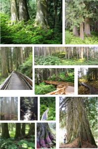
British Columbia’s inland temperate rainforest is over 500 kilometres from the coast (Figure 1). Globally, this is unique. Typically, rainforests exist along coasts where moisture-laden winds from the ocean soak lush forests rich in biodiversity and beauty. Rainforests exist inland where conditions are just right. The rarity of such conditions make inland temperate rainforests special.
Figure 1. Location of BC’s inland temperate rainforest
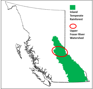
The scenery is also very striking, with very large trees covered in lichen and moss and a forest floor blanketed with ferns, Devil’s Club, and other vegetation. In the ancient stands of the upper Fraser Rive watershed, trees are three or more metres in diameter. The oldest trees are estimated to be 1,000 years or more, and perhaps up to 2,000 years. The largest documented tree, the tree along the Ancient Forest Trail known as “Big Tree,” measures 4.13 m in diameter.
Not only are individual trees old, so is the forest itself. The absence of natural disturbances, such as wildfire, landslides, and avalanches, means that some of these stands have not been disturbed for a long time. Among biologists, “ancient forests” denote stands of trees that have been in place for 1,000 years or more. This is why people who know these trees refer to them as the Ancient Forest. In the Lheidli dialect of the Dakelh language, chun t’oh whudujut refers to the “oldest trees.”
Block 486 is a film about these stands of ancient cedar trees. The title of the film refers to the number of a forest licence held at the time by TRC Cedar Inc., a local forestry company that produced cedar rails and posts for gardens, with byproduct sold as garden mulch. Block 486 contains some of the biggest, oldest trees in the watershed.
The film was released publicly at a screening in Prince George in November, 2006. After the film was shown, the floor was opened for questions with the film’s producer. David Radies, a graduate student at the University of Northern British Columbia (UNBC) who was studying the ancient cedars for his Master’s degree, was in the audience. Radies’ profound question captured what everyone in the room was thinking: “Why are we turning thousand-year old cedars into garden mulch?”
The film strikes at the heart of protected areas: When is a natural area worth protecting? What users, interests, and values must be considered?
The global significance of the forest’s ecological value was first documented in 1994 by Trevor Goward, which makes this a relatively new scientific discovery. As explained by Coxson, Goward, and Connell, the weather systems that support rainforests on BC’s west coast are also responsible for a secondary zone that supports the inland rainforest as the weather systems cross interior mountain ranges. The result is a zone of high precipitation, most of which falls as snow in the winter.
According to BC’s Biogeoclimatic Ecosystem Classification (BEC) system, the inland temperate rainforest is in the Interior Cedar-Hemlock (ICH) zone (Figure 2). Among the ICH subzones, the ancient forests of the upper Fraser River are in the very wet (v) and cool (k) subzones (ICH vk), largely due to its geographic location in the lower slopes of the Columbia and Rocky mountains.
Figure 2. Location of inland temperate rainforest (Interior Cedar Hemlock wetbelt) of upper watershed of Fraser River
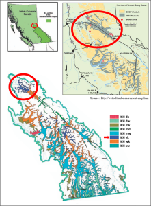
In this very wet, cool zone, the high-level snowpack is the essential source of water for the ancient cedars throughout the year. In the spring and summer, the melting snowpack migrates downslope, picking up nutrients along the way, and feeding the forest systems downslope. In particular, the water pools in toe slope areas, providing ideal conditions for what have become impressive stands of very large, old western redcedar.
Although people are readily impressed by the size and beauty of the cedars, the canopy of the ancient forest is also home to rich biodiversity. A scientific assessment of biodiversity of a small sample of the area identified more than 900 species, some red- and blue-listed species (endangered or near extinction in B.C. or even globally).
Importantly, the climatic conditions that create ideal conditions for the cedar also suppress stand-level wildfires. When lightning strikes, only a few trees might catch fire; the wet conditions prevent the fire from spreading (as evident in Figure 3). However, the stands will be subject to future impacts of climate change, which are largely unknown.
Figure 3. Western redcedar burning a few days after a lightning strike
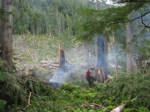
Chun t’oh whudujut, the “oldest trees,” are important to the Lheidli T’enneh. The stands of western redcedar are tied to their cultural practices and traditions and were sources of medicinal plants. The Lheidli visited the stands from summer fishing camps along the upper Fraser River.
The traditional territory of the Lheidli T’enneh (Figure 4), an area of over four million hectares, covers a diverse landscape. Significantly, the Fraser River traverses the whole of their area traditional territory, which also covers portions of the Rocky Mountains and extends to the Alberta border. The rivers and river valleys are essential to travel, trade, and culture based on hunting, fishing, trapping, and gathering.
Figure 4. Traditional territory of the Lheidli T’enneh
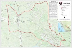
Within their territory, the areas where the Lheidli T’enneh lived and their activities varied by season. During the winter months, larger groups of the Lheidli T’enneh lived in semi-permanent villages of pit houses. In other seasons, family groups lived at seasonal camps throughout their traditional territory. Although these seasonal camps varied from year to year, family groups returned to key sites along rivers for salmon, on lakes for fishing in the spring, and in the mountains for hunting in the fall.
In recent years, the Lheidli T’enneh signed several economic benefit agreements with the Province of BC. These agreements aimed to ensure that Lheidli T’enneh would more fully benefit from the natural resources within their traditional territory while enhancing their social, economic, and cultural well-being of their members. In 1997, the Lheidli Nation established LTN Contracting Ltd., a timber harvesting company operated as a joint venture with Roga Contracting Ltd. The forest agreements have covered replaceable and non-replaceable licences as well as revenue sharing. Although the areas covered by these agreements include stands of ancient cedars, the focus of logging is in deciduous-leading harvest areas. In the Forest Tenure Opportunity “A&B” Agreement signed in 2011, the Lheidli T’enneh have access to 101,888 cubic metres annually via non-competitive bid, with a maximum volume of 509,440 over five years. The Forest Consultation and Revenue Sharing Agreement, signed in 2018, provides the Lheidli T’enneh with a portion of provincial revenues derived from timber harvesting with their traditional territory.
The Lheidli T’enneh have lived among the ancient forests for thousands of years. For others, the value of this unique landscape has been “discovered” several times in various forms. Alexander Mackenzie travelled through Lheidli territory in 1793 and was followed by Simon Fraser in 1808. A major incursion by non-Indigenous peoples was the Grand Trunk Pacific Railway, which started in Winnipeg and led to Prince Rupert. In 1911, the construction crew crossed the Alberta/BC border and then into the watershed of the upper Fraser River. Construction of the railway was completed in 1914.
From a settler perspective, the upper Fraser River watershed was a remote, bustling area. In her book on the history of the area, Marilyn Wheeler notes a brochure from 1914 promoting the area as the “new garden of Canada.” An early account described the area as a “picture of tremendous beauty,” but also an “eerie forest” that looked like “the Devil’s Cathedral.”
The next major incursion through the upper Fraser was the highway, completed in 1968. Highways tend to be constructed on the toe slopes of mountain areas. Unfortunately, as discussed above, these toe slopes are also prime areas for ancient stands of cedars. When the highway was built, it tended to be built through these stands, which is evident as one drives through the valley, seeing cedars on both sides of the highway.
As Wheeler documents, prior to the highway, the valley was dominated by small mills. The new highway, however, opened up the valley to a greater flow of people and products, including logs. As more logs were trucked out of the valley to Prince George, the local mills closed. Although cedar posts and poles continued to be shipped out of the area, the stands of giant cedars were not a prime area for logging. The larger cedars have hollow centres and tend to shatter when felled, thus reducing their economic potential while increasing harvesting costs. Although the low-timber value of the giant cedars meant that most areas were not logged extensively, the greatest impact on stands of ancient cedars was the construction of the highway through the valley.
There are a few small and medium-sized companies in the McBride area that are harvesting and processing western redcedar. Midget Mills is a second-generation family-owned and -operated custom saw mill using locally-harvested logs. In addition to western redcedar, they saw spruce, balsam fir, pine, Douglas fir, hemlock, poplar, and birch. For more than two decades, Cedar 3 Products produces split post and rail fencing, cedar bark mulch, and custom cedar furniture.
TRC Cedar also operated in the area, employing about 40-50 people. Using a more aggressive approach, TRC Cedar acquired volume-based licences to harvest looper-killed hemlock. When the market for salvaged hemlock dropped almost immediately and significantly, TRC Cedar requested permission to cut green wood and less salvage stands, including the cutting of “damaged” (i.e., low timber value) ancient cedars stands. The request was approved as a desirable balance between the salvage objective and maintaining local employment opportunities, thereby establishing the timber value of the ancient cedars as a priority. The government policy at the time viewed cedar as a “decadent” species that should be harvested and replaced by other faster-growing species. Most of the stands that TRC Cedar had identified for logging included the oldest, biggest, and most ecologically-significant stands of cedar. Their license included Block 486, which was the focus of the film. Block 482 is located a few kilometres west of Block 486 and was clear-cut around 2007 (Figure 5). In February 2008, TRC sold its forest licence to harvest the cedar-hemlock stands; the volume was transferred to beetle-attacked pine stands in the southern interior.
Figure 5. Block 482, clear cut
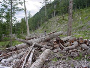
A few years after TRC ceased operations, the gap in the market was filled by BKB Cedar Manufacturing, which was established in 2013. BKB manufactures cedar post and rail fencing, as well as mulch and wood chips.
The McBride Community Forest Corporation (MCFC) has operated in the valley since 2007. The company, which is wholly-owned by the Village of McBride, has exclusive rights to harvest timber from an area surrounding the village. Under a Community Forest licence, the primary aims are to stimulate local economic activity and provide a monetary return back to the village and its residents. Spruce (41%) is the dominant species within the MCFC timber supply area, with subalpine fir (17%) and other species present. Western redcedar covers 16% of the area and is part of MCFC’s harvest plans.
Access to the ancient forest was enhanced greatly when the Ancient Forest Trail was built. The trail was born out of collaboration and coincidence. In 2005, a group of local residents from the Dome Creek area wanted to improve recreational access to stands of ancient cedars in the area. At the same time, members of the Caledonia Ramblers Hiking Society, a group of volunteers based in Prince George, were exploring ways to improve access to the Driscoll Ridge trail, which they maintain. Both groups were considering a new trail in the area of TRC Cedar’s Block 486. Figure 6 shows the first sketch of the proposed trail (dark blue line); it also shows the boundary of Block 486 (solid pink line) and a proposed access road for the logging operation (pink crosses). After getting permission from the province, the Ancient Forest Trail, a 2.5 km interpretive trail (Figure 7) built by volunteers (Figure 8), opened officially on June 4, 2006, the same year that the film Block 486 was released.
Figure 6. First sketch of proposed trail
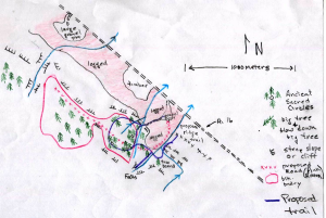
Figure 7. Ancient Forest Trail map
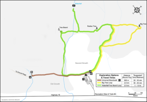
Figure 8. Nowell Senior Universal Boardwalk under construction, part of the Ancient Forest Trail.

Around this time, David Radies was conducting research on biodiversity in the area. During one of his trips into the stands of ancient cedar, Radies found flagging tape and markings on the trees in Block 486. Concerns rose immediately among local residents, scientists, and recreational users that the ancient cedars would be harvested within weeks. The conflict remained until TRC Cedar sold its licence.
In November, 2008, a Recreation Order established the Ancient Forest Trail as an interpretive site and the Driscoll Ridge Trail as a recreation trail.
It did not take long after the trail opened for word of the ancient cedars to spread. Visits to the trail increased dramatically. Estimates of visits to the Ancient Forest Trail indicate growth from 4,749 visits in 2008 to almost 15,000 visits in 2016 (Chart 1).
Chart 1. Ancient Forest Trail, estimated users (summer hiking season, 2008-2016)
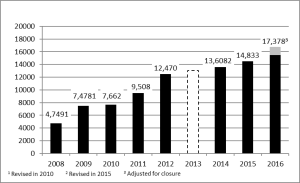
The Ancient Forest Trail has been walked by visitors from around the world. According to entries made in the visitor’s book at the trail head, visitors represent 12 Canadian provinces/territories, 28 states of the USA, and 26 countries outside North America.
The ancient forests of the upper Fraser River watershed are located on Crown lands, areas that are owned and managed by the Province of British Columbia. The management of these lands is governed by relevant provincial legislation such as the Forest and Range Practices Act and the Park Act. Within this policy regime, the aim is to maximise the timber value based on sustainable levels of harvesting and the primary means for allocating land uses is through timber supply analyses. Little priority is given to the non-timber forest values of the ancient cedars.
Stevenson et al. describe the historical development of logging in the inland temperate rainforest, including the stands of ancient cedars. Throughout the early days of settlers, logging was a daily chore, occupied with harvesting wood for buildings and fires. Small-diameter cedar was harvested regularly for poles; the outer shells of larger-diameter trees were used for shakes, shingles, fence posts, and fence rails. Over the many years since, harvesting has focused primarily on white spruce, Douglas fir, and subalpine fir, with redcedar constituting only a relatively small percentage of total volume logged. Notwithstanding their lower economic value, cedars remain a source of valuable shakes, shingles, posts, and rails. Harvesting and processing tended to be done by smaller companies. Over time, the volume of western redcedar harvested declined dramatically, yet remains a specified component of harvest quotas.
Since 1999, there have been a number of important developments regarding land use policy in the valley of the upper Fraser River. The development of comprehensive regional land use plans, which began in the 1990s, provides a starting point. At that time, the Province of BC revised its land use planning processes with the aim to incorporate more non-commercial values such as wildlife, tourism, and culture. This change centered on the development of Land and Resource Management Plans (LRMPs) that would govern all activities on public land.
The Prince George LRMP (1999) and Robson Valley LRMP (1999), which cover most of the ancient cedar stands, were intended to help guide forest development and established new protected areas. Although stands within the cedar-hemlock forests are valued as old-growth forests in the Prince George LRMP, and the plan included specific objectives for biodiversity and maintaining rare and common habitats, there is no mention of other special values associated with the ancient cedars. The Robson Valley LRMP states only, “Some of these cedar-hemlock forests are more than 500 years old and have areas with a variety of macrolichen species.” The LRMPs did lead to the designation of provincial parks that had specific objectives to protect some stands of old-growth cedar-hemlock.
Coxson, Goward, and Connell discuss land use policy governing old-growth stands. As they explain, stands of ancient cedars within the upper Fraser River watershed been managed as part of the timber harvesting land base with the implicit or explicit objective of sustained timber production over time. As stated by the province’s Chief Forester, it is “important to maintain old growth redcedar on the landscape for future generations and to meet requirements to manage old growth in the ICH.”
According to the provincial government’s 2004 “Old Growth Order,” 53% of upper Fraser forests was to be maintained as old forests. However, the status of this old growth order in the Prince George Timber Supply area is uncertain. Recommendations from the review of the mid-term timber supply state that “it is possible to increase mid-term timber supply in the Prince George TSA to 9.2 million cubic metres per year (almost the pre-beetle level) by removing the Prince George old growth order”. The report acknowledged risks associated with this recommendation, namely that “removing the requirement for old growth increases the risk of survival for those species and plant associations reliant on old growth habitats and structures”, and provides the caveat that “conserving remnants of these older forests, consistent with approved land use plans, is still extremely important”.
According to provincial policy, “old growth” includes trees that are more than 140 years old. This definition of old forests, which is used in the old growth order, has substantial limitations as a management tool for conserving ancient forest stands. The 53% target is set aspatially and has no long-term or defined boundaries; rather they may be located in different parts of the landscape as harvesting proceeds and managed landscapes evolve, regardless of species composition or site conditions. This fails to recognise the long-term site continuity and site-specific topographic factors which constrain the development of ancient cedar stands.
This policy gap was acknowledged by the Integrated Land Management Bureau (ILMB) in its 2008 report and, subsequently, led to designating many ancient cedar stands within old-growth management areas (OGMAs). In the upper Fraser watershed, these are spatially defined, some affording legal protection (so-called legal OGMAs), others simply constituting advice to industry on best practices and not legally binding (i.e., non-legal or “guidance” OGMAs). While these OGMAs provide near-term protection from logging, it must be stressed that OGMAs in general do not provide protection from other types of industrial development such as mining, hydroelectric development or road construction–a concern highlighted in a recent Forest Practices Board report.
Within legal OGMAs, forest industry contractors are mandated not to construct roads unless there is no other practicable option. However, the order establishing guidance OGMAs was silent on limitations respecting development activities.
As of 2008, none of the identified ancient forest stands fell within ecological reserves. While this designation would certainly be appropriate for some stands, the generally small size of ecological reserves in BC can limit their usefulness as a management option for conservation of landscape values. The only valley-bottom ecological reserve in the upper Fraser area is the Aleza Lake Ecological Reserve (242 ha), which protects a small area of old-growth sub-boreal spruce forest.
Similarly, only small patches of the ancient forest stands occur within protected areas or within BC provincial parks: 69 ha in Sugarbowl-Grizzly Den and 27 ha in Slim Creek Provincial Park (from B.C. Integrated Land Management Bureau 2008 mapping). This lack of representation within the B.C. provincial park system remains a major deficiency in landscape level planning in the upper watershed of the Fraser River.
As is the situation with any planning process, one can only do the best possible with information that is available—and this is a critical issue for the ancient cedar stands. Most of what we know about the ecological value of the ancient forest was discovered after the land use plans were completed, while the level of public interest and recreational use emerged even more recently.
The years immediately following the completion of the LRMPs include formal complaints by local residents to and responses from the Forest Practices Board (FPB). The FPB is an independent watchdog that conducts audits and investigations and issues public reports on how well industry and government are meeting the intent of BC’s forest practices legislation. The FPB has authority to make recommendations to the government.
25
PROTECTED AREAS CASE STUDY
In December, 2013, a small group of people representing hikers, academia, environmental groups, and the Lheidli T’enneh submitted a request (see below) to create a protected area for the ancient forests of the upper Fraser River watershed. In response to this proposal, BC Parks is currently assessing the feasibility of different levels of protection for the land base west of Slim Creek. The options considered are a combination of (a) type of protected area and (b) geographic scope of the protected area. All types of protected areas, in any combination, are being considered. Regarding the geographic scope, BC Parks is considering the three options prepared by Coxson, Goward, and Connell.
For discussion purposes, BC Parks prepared a consultation paper. The values, key issues, and opportunities outlined in this land use planning application are presented below.
BC Parks has invited you, as an expert in land use planning for protected areas, to a meeting among stakeholders during which the various options for protected area status will be discussed. Your task is to present an argument for a solution that considers the preservation of natural environments, use and enjoyment of the public, and the socio-economic interests of area residents.
To participate in this meeting, you have been asked to review all options available and come prepared to present and discuss what you believe to be the best option. Discuss how your option will provide more protection than what currently exists. As part of your deliberation, consider the following acts and regulations that govern British Columbia’s provincial parks and protected, including the following: Park Act; Ecological Reserve Act; Protected Areas of British Columbia Act; Park, Environment and Land Use Act; Conservancy and Recreation Area Regulation; Forest and Range Practices Act.
For legislation, refer to http://www.env.gov.bc.ca/bcparks/about/legislation.html
December 11th, 2014.
The Honourable Steven Thomson M.L.A. &
The Honourable Mary Polak M.L.A.
Parliament Buildings
Victoria, B.C.
V8V 1X2
Re: Ancient Forest Park Proposal
Dear Honourable Ministers:
Thank you for meeting with us regarding the designation of the Ancient Forest Trail area as a provincial park. In our discussions you had asked us to confirm the widespread support for the proposal to confer this designation upon the Ancient Forest Trail area. We are pleased to advise that major stakeholders remain highly supportive of these recommendations. The Lheidli T’enneh, forest tenure holders and community groups strongly support previous peer-reviewed scientific studies recommending greater protection and recognition for this unique ecosystem. There is also a workable agreement on the boundaries of what could be included in the provincial park designation. What now remains is a need to protect this globally recognized area, where ancient western redcedar stands provide an outstanding opportunity for the conservation of biological diversity and economic diversification in First Nation and regional communities.
Please accept this letter as a request for you to partner with us in submitting a formal proposal to the Government of British Columbia to designate the Ancient Forest area as a Provincial Park and develop a Park Management Plan between the Lheidli T’enneh and the Province of British Columbia. Once Provincial Park designation is conferred, we anticipate jointly moving forward with a nomination towards a UNESCO World Heritage Site designation.
We would be delighted to have a brief meeting with you both, either together or separately, at your earliest convenience to discuss the next steps in this journey.
Yours very truly,
Signatures on original
Dominic Frederick Chief, Lheidli T’enneh | Darwyn Coxson PhD Professor, Ecosystem Science and Management , UNBC | Dave Connell PhD, Associate Professor, Environmental Planning, UNBC | ||
Dave King, Director Caledonia Ramblers Hiking Club | Nowell Senior, President Caledonia Ramblers Hiking Club | Sarah Boyd, Executive Director PG Public Interest Research Group |
cc: the Honourable Shirley Bond MLA
December 11th, 2014.
MEMORANDUM TO: THE HONOURABLE STEVEN THOMSON MLA, MINISTER OF FORESTS, LANDS, AND NATURAL RESOURCE OPERATIONS & THE HONOURABLE MARY POLAK MLA, MINISTER OF ENVIRONMENT.
SUBJECT: Proposed Ancient Forest Trail Area Provincial Park Proposal
Recent research has identified a set of Ancient Cedar stands east of Prince George as a unique ecosystem in British Columbia, and indeed an area with globally significant conservation values. At present, these Ancient Cedar stands are managed as Old Growth Management Areas (OGMAs) in both formal and guidance OGMAs. Given the international significance of these stands we would propose that the Province extend provincial park designation to this area. This designation would allow nomination of the newly created park as a World Heritage site based on criteria identified by recent scientific review. Designation as a World Heritage site would further provide significant economic benefits to the region and province.
RECAP: THE ANCIENT FOREST – A GEM ON OUR DOORSTEP
The Ancient Forest Trail area represents a rare ecosystem within British Columbia’s inland wet temperate rain forest. This area is characterized by a unique combination of topography and microclimate which supports the development of large stature ancient Western redcedars, many of which are estimated at 1000 years in age or more. This area represents one of the best remaining examples of the inland temperate rain forest ecosystem in B.C. There is no other inland temperate rain forest on the planet that is so far (800 km) from the ocean. There are several reasons for conveying park status on the Ancient Forest Trail area. Extensive scientific research, including publications in peer-reviewed journals and books, confirms the globally significant nature of canopy biodiversity in the Ancient Cedar stands. With development of the Ancient Forest trail by community volunteers and with increasing visitor use has come broad-based recognition of the value of this site from stakeholder groups. Based on our feedback from these groups and the public we anticipate that the Province will have broad support for this proposal, whether from forestry, First Nations or community groups. This proposal, as articulated in the 2012 B.C. Journal of Ecosystems and Management publication (attached), has been assessed by staff from the B.C. Ministry of Forests, Lands, and Natural Resource Operations office in Prince George. We have been told that there were no significant concerns raised with reference to the park proposal in their review. In our discussions with BC MFLNRO staff they suggested that a modified park proposal boundary be developed, one that would be intermediate between the scenario 2 and 3 boundaries in the BC JEM article. We agreed that this modified boundary would satisfy scientific criteria while recognizing existing tenure inholdings such as Ministry of Transportation sites. We understand that this internal BC MFLNRO report is available to the Ministers.
WIDESPREAD SUPPORT FOR ANCIENT FOREST PROVINCIAL PARK PROPOSAL
As requested, we have confirmed support from all major stakeholders for the Ancient Forest Trail’s designation as a Provincial Park. We have held meetings with Lheidli T’enneh, Canfor, the Regional District of Fraser Fort George, Timber Supply Area and your ministries. All meetings have garnered widespread support for the park proposal. We feel confident that we have done our due diligence in meeting with stakeholders. We are now requesting that you partner with us by submitting a formal proposal to the Government of BC to designate the Ancient Forest Trail area as a Provincial Park.
OPPORTUNITIES TO BE REALIZED THROUGH PROVINCIAL PARK DESIGNATION
WORKING TOWARDS WORLD HERITAGE SITE STATUS
The Ancient Forest Trail area is currently protected under provincial recreation and old growth management area designations. Although these designations have their merits, comparable sites around the world have a much higher level of protection. In order to protect the Ancient Forest in the long term, we would like to propose that this area be designated as a provincial park co-managed with the Lheidli T’enneh, with the future goal of it being nominated as a UNESCO World Heritage Site. The Ancient Forest is a gem in this geographical region, one that has the potential to provide significant educational, scientific and regional development legacies for all British Columbians. Designation would result in much higher visitor use and be a huge boost to the local economy.
ASSISTANCE REQUESTED:
We are requesting that you partner with us in submitting a formal proposal to the Government of British Columbia to designate the Ancient Forest area as a Provincial Park. We would welcome your leadership within government to work towards protecting this unique area that will benefit communities in the Robson Valley and Prince George region. As such, we would like to request that a brief meeting be arranged to meet with Minister Thomson and Minister Polak, either together or separately, to discuss next steps in working towards provincial park designation.
In developing the park proposal for the Ancient Forest, discussions were held with (besides your ministries and representatives of the organizations listed in the contact section below):
Attachments:


CONSULTATION PAPER2
Ancient Forest/Chun T’oh Whudujut
Overview
The Province is working with the Lheidli T’enneh First Nation and the Caledonia Ramblers Hiking Society, other community stakeholders and the public to protect the unique ecosystems of the Ancient Forest/Chun T’oh Whudujut.
The forest covers more than 12,000 hectares of largely unlogged inland temperate rainforest,
and contains stands of giant red cedars, some more than 1,000 years old, as well as rare plants
and lichens. The forest is 120 kilometres east of Prince George next to Slim Creek Provincial
Park.
The partners are working together to ensure the Ancient Forest, called Chun T’oh Whudujut in
the Lheidli dialect, is preserved and, in the long term, established as an official protected area
under provincial legislation.
The Province plans to set aside up to 12,000 hectares as a specially designated area designed to
protect the Ancient Forest’s unique ecosystem, and is currently seeking public input into the
plan to protect this critical site. Key questions include:
Your input will inform decisions for formally protecting the Ancient Forest and Driscoll Ridge
area, and government will announce the plan in 2016.
The Ancient Forest Today
While coastal temperate rainforests occur elsewhere including Chile, New Zealand, and
Norway, the Ancient Forest is part of the Interior Cedar Hemlock Forest, the only known and
described inland temperate rainforest on Earth. The climatic and historic conditions in the
forest have allowed for the development of high species diversity, including canopy lichens, and
the area contains the best concentration of rare, old, inland cedar-dominated ecosystems in
B.C.
In fact, the area is so unique that a 2012 discussion paper by researchers from the University of Northern B.C. called for the forest to be designated a UNESCO World Heritage Sites, like SGang Gwaay on Haida Gwaii and the Canadian Rocky Mountain parks in B.C. and Alberta.
Under an existing regional land and resource management plan, almost one-third of the forest
– some 4,600 hectares — is designated as old growth management areas. This ensures that no
management decisions are made without careful considering the biodiversity needs of the
area. While the land use plan will not be reopened, an increase in the size of the protected
area is consistent with the original intent of the plan.
Once government has set up the new protected area, the partners will develop a management
plan for the area, to ensure the long-term the Ancient Forest and preservation and protected
for generations to come.
First Nations
Ecological Values
Resource Industry
Recreational Activities
Potential UNESCO Designation
The Province supports the call to have Ancient Forest designated a UN World Heritage Site. The
process for nominating World Heritage Sites in Canada is coordinated by the federal government.
Canada currently has nine Natural World Heritage Sites and eight Cultural World Heritage Sites. There are three designated UNESCO sites in British Columbia:
To be considered by UNESCO as a World Heritage Site, the area must first have adequate
protection – which is part of the reason for the current review. The proposed park must meet
some of UNESCO’s selection criteria, which includes that it:
Once established as a park, the site must then be endorsed by Canada and formally nominated by the Federal government. Such nomination requires that the area has the following:
26
PROTECTED AREAS CASE STUDY
Directory of all BC Laws
Park Act [RSBC 1996] CHAPTER 344
Ecological Reserve Act [RSBC 1996] CHAPTER 103
Ecological Reserve Regulations B.C. Reg. 335/75 O.C. 1456/75
Protected Areas of British Columbia Act [SBC 2000] CHAPTER 17
Environment and Land Use Act [RSBC 1996] CHAPTER 117
Park, Conservancy and Recreation Area Regulation B.C. Reg. 180/90 O.C. 867/90
Ministry of the Environment Act [RSBC 1996] CHAPTER 299
Forest and Range Practices Act [SBC 2002] CHAPTER 69
BC Parks – overview of legislation
VII
27
LEARNING MODULE
The rural planning case about access to a rural subdivision raises questions about options for legal recourse that may be available to people and organisations that oppose a particular decision. The following module lays out some of these options in very general terms. Please be advised that the following material does not constitute legal advice; they are for discussion only as part of the teaching materials included in this textbook.
1. In the absence of an appeal mechanism in the land legislation, one avenue of recourse might be to apply to the BC Supreme Court for judicial review of the approving officer’s decision to issue the road tenure. There might be time limit considerations and the applicant would have to show standing (i.e. a legally-recognizable “stake” in the issue) but it is a possibility. There is an example of judicial review of a land tenure decision in the Redmond case, albeit that was about denying an application.
2. The standard of review is the “reasonableness” of the ministry’s approval decision, which is determined according to the five criteria listed in paragraph 22 of the Redmond decision. The issues of slope stability and unknown ecosystem impacts might be able to be brought into determining whether the ministry acted reasonably.
3. Judicial review is governed by the Judicial Review Procedure Act and requires approval from the court to proceed but it is an option in the right circumstances.
4. There is also the option of simply suing the Crown for damages if a party suffered loss of some sort by the road approval. Again, the party would have to show standing and a recognized form of loss such as economic loss, devaluation of their property, traffic nuisance, etc.
5. Regarding the Community Forest, it would be worthwhile to review the particular agreement that they have with the ministry. Any community forest agreements that I am familiar with exclude roads and other tenures from the community forest tenure, but it never hurts to confirm.
6. If there are any further permits associated with the road tenure, it may open up recourse under other statutes. For example, a timber clearing permit improperly granted or exercises might open the door to an appeal under the Forest Appeals Commission.
7. If there are fisheries issues related to the slope instability, the Department of Fisheries and Oceans might be brought into the picture, or possibly the provincial Environmental Appeals Board if the province issues any permits that might impact fish or other environmental values. These are very longshots but may be enough to found a negotiation.
8. The silence of First Nations is in and of itself likely to have little effect as long as they had reasonable opportunity to respond. The courts have clearly determined that consultation is a two-way street, so a First Nation that does not respond to a request for consultation is at its peril.
28
LEARNING MODULE
As per s. 83(1) of the Land Title Act, all subdivisions in British Columbia (BC) must be approved by an Approving Officer (AO).
In this learning module, we draw primarily from the following two resources:
Ministry of Transportation and Infrastructure. Subdividing Land Outside a Municipality
Ministry of Transportation and Infrastructure (2021). Guide to Rural Subdivision Approvals [pdf].
One key piece of relevant legislation is the Land Title Act. The most relevant sections of the Act are included at the end of this document.
When someone subdivides land, they are usually creating new lots from one or more parcels of land; that is, they are subdividing one parcel into multiple lots. In more precise legal terms, a subdivision creates new, titled parcels of land. Subdivision of land also includes, but is not limited to, creating lots in a bare land strata development, re-adjustment of an existing property line, as well as the consolidation of properties.
Municipalities, regional districts, and the Ministry of Transportation and Infrastructure (MoTI) can have roles in the application and approval process of subdivisions, depending on whether the land to be subdivided is inside or outside of a municipality. If the land to be subdivided is located in a municipality, then the application is submitted to that municipality. If the land to be subdivided is located outside of a municipality, then the landowner (developer) applies to a MoTI District Office.
As per the Land Title Act (s. 83(1)), all rural subdivisions must be approved by an Approving Officer (AO). Which AO is responsible for a subdivision depends on where the land to be subdivided is located, as follows.
83 (1) A subdivision plan must be tendered for examination and approval by the approving officer as follows:
(a) if the land affected is within a municipality, to the designated municipal officer;
(b) if the land affected is in the rural area of a regional district authorized to appoint an approving officer under section 77.1, to the designated regional district officer;
(c) if the land affected is in the rural area of the trust area under the Islands Trust Act and the trust council is authorized to appoint an approving officer under section 77.1, to the secretary of the trust council;
(d) in other cases, to the district highways manager of the Ministry of Transportation.
Although s. 77.1(1) of the Land Title Act enables a regional district to appoint an AO, there are no regional district AOs in the province. As such, s. 77.2(1) of the Act applies, whereby a Provincial Approving Officer (PAO) is responsible for approving all rural subdivisions. The PAO is a staff member of MoTI.
In addition to municipal AOs and PAOs, the Act requires that AOs be appointed for Indigenous treaty lands and for Nisga’a lands, as follows.
Appointment of treaty first nation approving officers
77.21 (1) A treaty first nation must appoint an approving officer for its treaty lands.
Nisg̱a’a approving officer
77.3 (1) The Nisg̱a’a Lisims Government must appoint an approving officer for Nisg̱a’a Lands.
An AO does not have to be a professional planner. The Act states that the person appointed can be the chief engineer, chief planning officer, or “some other employee” of the local government or First Nation. An AO can also be a person under contract to a local government or First Nation.
The roles and responsibilities of an AO are established under section 77 of the Land Title Act. When reviewing an application for subdivision, an AO must consider the interests of the applicant (such that the probability the applicant’s proposed subdivision will be approved), of future owners of individual lots, and of broader public interests. As such, an AO must act independently when considering whether the proposed subdivision is appropriate for the site, complies with provincial acts and regulations, and complies with local government by-laws. Factors an AO must consider include the following:
As part of the review process, the AO may require the application to complete assessments, such as geotechnical, archaeological, environmental, hydrological, and soils assessments. Section 86(1)(c) sets out conditions that an AO may consider as grounds for refusing an application.
After an application is approved, the applicant registers the subdivision plan (including any other necessary documentation, such as restrictive covenants, easements, and rights-of-way) with the Land Title Office and new lots are created.
APPENDIX
[RSBC 1996] CHAPTER 250
The following are selected sections of the Act relevant to rural subdivision.
Division 3 — Appointment, Powers and Duties of Approving Officers
Appointment of municipal approving officers
77 (1) For land within a municipality, the municipal council must appoint a person as an approving officer.
(2) An approving officer appointed under this section must be
(a) the municipal engineer,
(b) the chief planning officer,
(c) some other employee of the municipality appointed by the municipal council, or
(d) a person who is under contract with the municipality.
Appointment of regional district and islands trust approving officers
77.1 (1) Subject to subsection (2), the Lieutenant Governor in Council may, by order, do one or more of the following:
(a) authorize a regional district board to appoint a person as an approving officer for the rural area of the regional district;
(b) authorize the trust council under the Islands Trust Act to appoint a person as an approving officer for the rural area of the trust area under that Act;
(c) if an order under paragraph (a) or (b) applies, provide that section 83.1 does not apply in relation to the regional district or trust area.
(2) An order under subsection (1) (a) or (b) must be requested by resolution of the regional district board or trust council, as applicable, and must be recommended by the minister charged with the administration of the Transportation Act.
(3) An order under subsection (1) (a) or (b) may include one or more of the following:
(a) requirements that must be met before the authorization becomes effective;
(b) conditions relating to the appointment of the approving officer under this section;
(c) provisions respecting the transition to the exercise of authority by an approving officer appointed under this section including, without limiting this, exceptions and modifications respecting how applications that are pending at the time the authorization becomes effective are to be dealt with.
(4) If a regional district board or the trust council is authorized under subsection (1), it must appoint an approving officer for the rural area of its jurisdiction.
(5) An approving officer appointed under this section must be
(a) the regional district or trust area engineer,
(b) the chief planning officer,
(c) some other employee of the regional district or trust council appointed by the board or council, as applicable, or
(d) a person who is under contract with the regional district or trust council.
Provincial approving officers
77.2 (1) If an approving officer is not appointed under section 77.1 for a rural area, the approving officers for the area are
(a) the deputy minister to the minister charged with the administration of the Transportation Act, and
(b) approving officers appointed under subsection (2).
(2) The Lieutenant Governor in Council may appoint a person as an approving officer for a rural area referred to in subsection (1).
Appointment of treaty first nation approving officers
77.21 (1) A treaty first nation must appoint an approving officer for its treaty lands.
(2) An approving officer appointed under subsection (1) must be
(a) an official or employee of the treaty first nation, or
(b) a person who is under contract with the treaty first nation.
(3) Sections 77.1 and 77.2 do not apply to the treaty lands of a treaty first nation.
Nisg̱a’a approving officer
77.3 (1) The Nisg̱a’a Lisims Government must appoint an approving officer for Nisg̱a’a Lands.
(2) The approving officer appointed under subsection (1) must be
(a) an official of the Nisg̱a’a Lisims Government, or
(b) a person who is employed by or under contract with the Nisg̱a’a Nation.
(3) The approving officer appointed under subsection (1) may exercise his or her powers in relation to all Nisg̱a’a Lands, including Nisg̱a’a Village Lands.
(4) Sections 77.1 and 77.2 do not apply to Nisg̱a’a Lands.
Division 4 — Approval of Subdivision Plans
Tender of plan for examination and approval
83 (1) A subdivision plan must be tendered for examination and approval by the approving officer as follows:
(a) if the land affected is within a municipality, to the designated municipal officer;
(b) if the land affected is in the rural area of a regional district authorized to appoint an approving officer under section 77.1, to the designated regional district officer;
(c) if the land affected is in the rural area of the trust area under the Islands Trust Act and the trust council is authorized to appoint an approving officer under section 77.1, to the secretary of the trust council;
(d) in other cases, to the district highways manager of the Ministry of Transportation.
(2) The subdivision plan must be accompanied by the following:
(a) the applicable fees established under section 462 (1) (f) of the Local Government Act or under section 292 (1) (h) of the Vancouver Charter or prescribed under subsection (3) of this section;
(b) a certificate
(i) that all taxes assessed on the subdivided land have been paid, and
(ii) if local service taxes are payable by instalments, that all instalments owing at the date of the certificate have been paid;
(c) if the approving officer considers that there is reason to anticipate that the land may be resubdivided and requires this information, a sketch showing that the parcels into which the land is subdivided can conveniently be further subdivided into smaller parcels;
(d) if the approving officer requires this information, profiles of every new highway shown on the plan and such necessary topographical details as may indicate engineering problems to be dealt with in opening up the highways, including environmental impact or planning studies.
(3) The Lieutenant Governor in Council may, by regulation, prescribe fees for subdivision plan examination by a Provincial approving officer, which may vary with the number, size and type of parcels involved in the proposed subdivision.
Matters to be considered by approving officer on application for approval
86 (1) Without limiting section 85 (3), in considering an application for subdivision approval, the approving officer may
(a) at the cost of the subdivider, personally examine or have an examination and report made on the subdivision,
(b) hear from all persons who, in the approving officer’s opinion, are affected by the subdivision,
(c) refuse to approve the subdivision plan, if the approving officer considers that
(i) the anticipated development of the subdivision would injuriously affect the established amenities of adjoining or reasonably adjacent properties,
(ii) the plan does not comply with the provisions of this Act relating to access and the sufficiency of highway allowances shown in the plan, and with all regulations of the Lieutenant Governor in Council relating to subdivision plans,
(iii) the highways shown in the plan are not cleared, drained, constructed and surfaced to the approving officer’s satisfaction, or unless, in circumstances the approving officer considers proper, security is provided in an amount and in a form acceptable to the approving officer,
(iii.1) a highway provided for in a subdivision plan or otherwise legally established on lands adjoining, lying beyond or around the land subdivided is, in the approving officer’s opinion, not sufficient,
(iv) the land has inadequate drainage installations,
(v) the land is subject, or could reasonably be expected to be subject, to flooding, erosion, land slip or avalanche,
(vi) after due consideration of all available environmental impact and planning studies, the anticipated development of the subdivision would adversely affect the natural environment or the conservation of heritage property to an unacceptable level,
(vii) the cost to the government of providing public utilities or other works or services would be excessive,
(viii) the cost to the municipality or regional district of providing public utilities or other works or services would be excessive,
(ix) the subdivision is unsuited to the configuration of the land being subdivided or to the use intended, or makes impracticable future subdivision of the land within the proposed subdivision or of land adjacent to it,
(x) the anticipated development of the subdivision would unreasonably interfere with farming operations on adjoining or reasonably adjacent properties, due to inadequate buffering or separation of the development from the farm, or
(xi) despite subparagraph (ix), the extent or location of highways and highway allowances shown on the plan is such that it would unreasonably or unnecessarily increase access to agricultural land within the agricultural land reserve, as those terms are defined in the Agricultural Land Commission Act, and
(d) if the approving officer considers that the land is, or could reasonably be expected to be, subject to flooding, erosion, land slip or avalanche, the approving officer may require, as a condition of consent to an application for subdivision approval, that the subdivider do either or both of the following:
(i) provide the approving officer with a report certified by a professional engineer or geoscientist experienced in geotechnical engineering that the land may be used safely for the use intended;
(ii) enter into one or more covenants under section 219 in respect of any of the parcels that are being created by the subdivision.
(2) The Lieutenant Governor in Council may, by regulation, amend, add to, substitute or repeal any of the grounds for refusal set out in this section or in section 85 (3).
Local government matters to be considered by approving officer
87 Without limiting section 85 (3), the approving officer may refuse to approve a subdivision plan if the approving officer considers that the subdivision does not conform to the following:
(a) all applicable provisions of the Local Government Act;
(b) all applicable municipal, regional district and improvement district bylaws regulating the subdivision of land and zoning;
(c) if the land affected is within the trust area under the Islands Trust Act, all applicable local trust committee bylaws regulating the subdivision of land and zoning.
Approval of plan
88 On the approval of a plan, the approving officer must write on it “Approved under the Land Title Act” with the date of approval and must sign it and append below his or her signature the title
Approving Officer for
……………………………………………………………….
(municipal, or as the case may be)
……………………………………………………………….
(name of municipality, or as the case may be).
29
This module introduces readers to opportunities for a career as a professional planner in local government. We begin by describing the typical requirements for an entry-level position and how a person becomes a Registered Professional Planner (RPP), which is the official designation of a professional planner. We also provide a list of colleges and universities that offer planning diplomas and degrees in British Columbia (BC).
Having addressed the requirements for becoming a professional planner, we describe employment opportunities in three different contexts: the City of Nelson as an example of a small city; the City of Prince George as an example of a medium-sized city; and the City of Vancouver as an example of a large city. Our aim is to describe a wide range of opportunities for a career as a professional planner in local government.
Most professional planners work for local governments (municipalities and regional districts). Common titles of planning positions include the following, listed from junior to senior positions:
Professional planners also work in the provincial government, usually in ministries that have some jurisdiction over the use of land. These job positions can be with ministries responsible for municipal affairs, housing, transportation, Crown lands, environment, parks, and forestry, among others. Planners also work for consulting firms that specialise in community planning, land use planning, property development, and for other private, non-profit, and public enterprises. Collectively, the work of planners covers different areas of expertise, such as community planning, re-zoning, economic development, climate change and adaptation, public spaces, housing, affordable housing, and transportation, among others.
CivicInfo BC is an excellent source for current planning-related job positing in local governments.
Although the formal titles of planner positions vary, Planner I is a common entry position in smaller and medium-sized municipalities. From this position, a person can be promoted to Planner II and then Planner III. In a large city with a large planning department, entry-level positions also include Planning Assistant and Planning Analyst.
The responsibilities of a Planner I cover the essential, day-to-day aspects of land use planning within a local government. The duties are often described as “front counter” services because a Planner I is often the first point of contact with members of the public, including residents and businesses. This planning work includes the following:
Typically, to qualify for a Planner 1 position, an applicant has a degree in land use, environmental, or regional planning recognised by the Canadian Institute of Planners (CIP). T his educational requirement should be complemented with some related experience. Almost all positions require the candidate to have or be eligible for membership with CIP. Membership is explained next.
To be a professional planner, a person must successfully complete the formal process to become certified. When certified, a professional planner has the exclusive right and privilege to use the “Registered Professional Planner” (RPP) designation.
The association for professional planners in BC is the Planning Institute of British Columbia (PIBC). There is also a national association, the Canadian Institute of Planners (CIP). A certified planner and member in good standing may also use the designation “MCIP” to indicate their membership in CIP. The certification process is administered by the Professional Standards Board on behalf of PIBC.
For information about becoming a certified professional planner, visit the following websites:
Planning Institute of BC – Membership
Canadian Institute of Planners – Membership
There are different paths to become a certified professional planner and member of CIP based on different combinations of work experience and education. The most effective path is to complete a university degree through an accredited program, as this degree is the most common qualification for planning positions.
Just as people are certified as professional planners, planning degrees offered by universities are also certified (accredited), which means that the degree meets the curriculum requirements established by the Professional Standards Board. The following universities offer a full-time accredited planning degree in BC (Table 1).
Table 1. Universities in BC offering a full-time accredited planning degree
University | Program | Degree |
Undergraduate degree | ||
Simon Fraser University | ||
University of Northern British Columbia | ||
Graduate degree | ||
Simon Fraser University | ||
University of British Columbia | ||
Vancouver Island University | Social Sciences | |
In addition to the above, there are other, non-accredited avenues to pursue planning-related education, including, but not limited to, the following:
The following examples of three municipal planning departments illustrate the breadth of career options as a professional planner. As the examples show, in a small city, a professional planner can be responsible for the full range of planning duties. As municipalities get bigger, so does their planning department. Correspondingly, each planning position also becomes more specialised. In smaller municipalities (villages and towns), land use planning is often only a part of one person’s job and a planning-related degree may not be required.
The City of Nelson, located in the Selkirk Mountains in Southern Interior BC, has a population of 11,106 (2021 Census). As shown in the city’s organisational chart (Figure 1), planning services are part of the Development Services department.
Figure 1. Organisational chart, City of Nelson

A detailed job posting for a Planner I with the City of Nelson demonstrates the breadth of responsibilities of a planner in a small city (see Box 1). This planner is responsible for most aspects of planning for the City. Qualified applicants required a university degree in Planning; a Master’s degree in Planning is desirable.
Position posted February 15, 2023
Source: CivicInfo BC
Reports to: Director, Development Services and Climate Action
Department: Development Services and Climate Action
Reporting to the Director of Development Services and Climate Leadership, the Planner 1 will focus on current planning projects with opportunities to assist in long-range planning tasks.
The City of Prince George, located in Central Interior BC, has a population of 76.708 (2021 Census). As shown in the city’s organisational chart (Figure 2), planning services, named Development Services, are part of the Planning and Development department.
Figure 2. Organisational chart, City of Prince George

In this medium-sized city, there are at least five levels of planning positions within the department. T hese positions include Planning Technician, Planner I, Supervisor of Land Use Planning, Manager of Planning Services, and Director of Planning and Development Services. The responsibilities and qualifications for each of these positions are summarised, as follows. Most likely, there are also Planner II and Planner III positions based on promotions.
Planning Technician
Responsibilities
Qualifications
Planner 1
Responsibilities
Qualifications
Supervisor, Land Use Planning
Responsibilities
Qualifications
Manager, Development Services
Responsibilities
Qualifications
Director, Planning & Development Services
Responsibilities
Qualifications
The population of the City of Vancouver is 662,248. As a metropolitan centre, the City has tremendous demands on land use planning for all uses: residential, industrial, commercial, retail, hospitality, institutional, transportation. These demands are reflected in the specialised planning positions within the Department of Planning, Urban Design, and Sustainability. The organisation chart for the City (Figure 3) shows only the department-level structure.
Within the Department, many professional planners are required to cover all areas of responsibilities. In a large local government like the City of Vancouver, planning positions at all levels of the organisation can be specialised. The following table (Table 2) lists some of the junior planning positions within the City, including Planning Assistant, Planning Analyst, and Planner I. For many of these positions, Membership or eligibility for membership in the Canadian Institute of Planners is desirable.
Figure 3. Organisational Chart, City of Vancouver

Table 2. Partial list of professional planning positions, City of Vancouver
Planner position | Brief statement of responsibilities | Qualifications |
Planning Assistant | ||
Planning Assistant III (Community Planning) | Provide technical and professional support related to the implementation of the Vancouver Plan. Reports to a Planner II with support and oversight from a Senior Planner. | Grade 12 or equivalent supplemented by related courses in building related issues such as design, construction, permitting etc. Experience as a Planning Assistant II preferred. Current Planning experience preferred. University degree in Planning would be considered an asset. |
Planning Assistant III (Street Activities) | Help implement the Street Activities Programs, and related policy and program development focused on advancing the City’s public space goals. Under the direction of the Planner II in Street Activities. | Grade 12 or equivalent, supplemented by or including post-secondary training in planning, public policy, or a related field. |
Planning Assistant III (Climate Adaptation and Green Infrastructure Implementation) | Help implement the Rain City Strategy on private and city-owned property. Related to green rainwater infrastructure such as blue/green roofs, rainwater harvesting, and infiltration systems such as rain gardens. | Grade 12 or equivalent; experience as a Planning Assistant II preferred; current planning experience preferred. |
Planning Analyst | ||
Planning Analyst (Rezoning Centre) | Provide technical and professional support with a focus on the processing and review of rezoning applications and related functions. Includes responsibilities associated with Public Hearings and enactment of by-laws, responses to written rezoning enquiries, preparation of reports, and support of public consultation processes. | University degree in Planning and some professional planning experience or related university degree with experience related closely to the duties involved. Familiarity with rezoning processes and a working knowledge of zoning and land-use regulations, land development economics and urban design principles is strongly preferred. |
Planning Analyst (Community Planning) | Provides a range of technical, analytical and graphic support to the Community Planning Division. Focuses on the implementation of community and area plans. Responsibilities include research, analysis, mapping, preparation of reports, and preparing communication materials. | University degree in Planning with some professional planning experience. Experience in Rezoning or Development Planning is preferred. |
Planning Analyst (Community Engagement) | Responsible for the coordination of project and policy research, and development of public engagement processes supporting the delivery of transportation and public realm projects. May supervise junior staff. | University graduation and some professional experience in a field related to transportation and/or urban planning. Experience in providing engagement processes and knowledge of International Association for Public Participation principles is an asset. |
Planning Analyst (Reconciliation and Culture Change) | Responsible for supporting the public consultation process including public open houses, workshops, public hearings, and may include enactment of by-laws, and providing responses to written policy, development and rezoning enquiries in the context of reconciliation, redress and equity. | University degree in Planning. Some professional planning experience. Experience in Rezoning or Development Planning is preferred. |
Planning Analyst (Economic Development) | Provides a range of technical, research and graphic support to the City-wide and Regional Planning Division and primarily assists the Economic Development Planning team. Responsibilities include research, data collection and analysis, mapping, providing graphic support, drafting presentations and organizing public consultations. | University degree in Planning or a related field with some professional planning experience. Familiarity with rezoning processes and a working knowledge of zoning and land-use regulations, land development economics and urban design principles is strongly preferred. |
Planning Analyst (Transportation) | Responsible for the delivery of research into policy, socio-demographic, economic and spatial data, as well as the delivery of stakeholder and public engagement activities. Reports to Transportation Planner II. | University graduation and some professional experience in a field related to transportation, urban planning and/or urban design. |
Planner I | ||
Planner I | Provide professional and technical services towards the development of by-laws, policies and land use regulations with a city-wide focus. Carry out research and analysis to support land use regulation and policy work as well as providing regulatory advice on existing City by-laws and policies. | A degree in Urban Planning, or a related field, recognized by the Canadian Institute of Planners. Minimum of one year of related professional experience. |
Planner I | Responsible for reviewing rezoning applications and for advising on and preparing policy, zoning and guidelines. | A degree in urban planning, or a related field, recognized by the Canadian Institute of Planners. A minimum of two years of related professional experience. Experience facilitating a participatory public consultation process. |
Planner I | Responsible for working on a comprehensive analysis and update of the current development (rezoning and development permit) process, system and procedures. Responsible for reviewing rezoning and development permit applications and for advising on and preparing policy, zoning and guidelines. | A degree in Urban Planning, or a related field, recognized by the Canadian Institute of Planners. Building Renovation and/or Urban Design experience. Experience facilitating a participatory public consultation process and negotiating and mediating among various interest groups. |
Planner I | Provide professional and technical services towards the implementation of the recently adopted Vancouver Plan, community plans, as well as the development of new area plans. Include providing professional services to support policy enquiries, rezoning enquiries and rezoning applications, as well as land use policy and new guidelines and district schedules. Communication with residents and stakeholders, as well as collaboration with other City departments and external agencies will be a key aspect of this position. | A graduate degree in planning or a related discipline, recognized by the Canadian Institute of Planners. Minimum of one year of related professional experience. |
Planner I | Responsible for supporting shared micro-mobility and commercial and public uses in the street right-of-way and public realm. A key project in this portfolio will be supporting the development of a shared e-scooter pilot program from start to finish. | A degree in Planning, Landscape Architecture, architecture, or a related field, preferably at the post-graduate level, plus a minimum of 2 years of related professional experience. |
Planner I | Key focus areas of the role will be to draft policy and reports, provide policy advice for rezoning enquiries and applications, participate in community engagement activities, prepare work plans, and supervise consultant studies. Projects include the implementation of the Broadway Plan and Northeast False Creek Plan, Central Waterfront planning, UBCx planning and the Jericho Lands. | A post-secondary degree in planning recognized by the Canadian Institute of Planners is preferred and a minimum of one year related professional experience in the planning field, or an equivalent combination of post-secondary education and experience. |
Planner I | Work will involve ongoing work with (a) projects, emerging policies and initiatives related to public space, (b) public engagement on plans and strategies, and (c) developing partnerships and coordinating stewardship efforts for public spaces. | A degree in Planning recognized by the Canadian Institute of Planners and a minimum of one year related professional experience. Experience in urban and spatial design, creating design guidelines, and public space planning and stewardship. |
Planner I | Responsible for supporting the City’s Business Improvement Areas and small business support programs. Responsible for providing policy advice on rezoning and development applications and for providing research and data services for the broader team. | A graduate degree in planning recognized by the Canadian Institute of Planners and a minimum of one year related professional experience. |
30
LEARNING MODULE
The conflict between the Wet’suwet’en Nation and the Coastal GasLink pipeline has attracted national attention, and deservedly so. The crossing of the pipeline through the traditional territory of the Wet’suwet’en (yintah) is a conflict between Indigenous rights to govern land, government policies and priorities (e.g., environment versus economic development), corporate interests, and police. This situation also highlights differences between the traditional governance of traditional lands by Hereditary Chiefs and the statutory limits of First Nations Bands, which are creations of the Indian Act.
The full scope of the conflict over the Coastal GasLink pipeline cannot be covered within this Learning Module. The aim is to provide a general description of the situation and to highlight major sources of tension. Content includes a description of the pipeline and of different perspectives of the pipeline, including TC Energy, Wet’suwet’en Hereditary Chiefs, and First Nations of the Wet’suwet’en. A list of chronological events since 2012 covers some of the incidents and arrests that have occurred between the RCMP and Wet’suwet’en Land Defenders.
About the pipeline
The Coastal GasLink pipeline began in 2020 and is currently under construction at a cost of about $40 billion. The purpose of the pipeline is to transport natural gas from the oil and gas fields in northeast British Columbia (BC) near Dawson Creek to a liquid natural gas facility located on the central west coast near Kitimat. The gas facility, owned by LNG Canada, will convert the gas to a liquid form and export the liquid natural gas to global markets. The pipeline is approximately 670 kilometres long and will deliver 2.1 billion cubic feet per day (bcf/d) of natural gas with the potential to deliver up to 5 bcf/d. Figure 1 illustrates the route of the pipeline, which goes over mountain passes, crosses salmon-bearing rivers, and overlaps many Indigenous territories. As shown on the map, the project to build the pipeline is divided into eight sections, numbered from Section 1 in the east to Section 8 in the west. Figure 2 shows the location of First Nations along the route. Figure 3 shows the pipeline crossing about 190 kilometres of the 22,000 square-kilometre Wet’suwet’en traditional territory and the location of First Nations within the territory. This part of the pipeline corresponds with Sections 6, 7, and 8 shown in Figure 1. Figure 4 shows the pipeline route in relation to the Clans of the Wet’suwet’en Nation.
Figure 1. Route of the Coastal GasLink pipeline
Figure 2. Location of First Nations along the pipeline route
Figure 3. Section of pipeline crossing Wet’suwet’en traditional territory
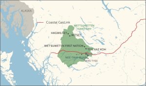
Figure 4. Clans of the Wet’suwet’n and location of pipeline route
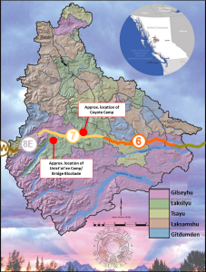
As of March 30, 2023, according to TC Energy’s update, the pipeline is more than 85% complete with an estimated completion date in 2023. For Section 7, the section of the pipeline where most of the conflict is taking place, 100% of the route is cleared, 92.1% of grading is complete, and 51.5% of pipe is installed. This percentage of installed pipe in Section 7 is the lowest of all sections; the next lowest is Section 6 at 70.9%. For Section 6, 100% of the route is cleared, 97.8% of grading is complete. Some of the other sections of the pipeline are fully completed or close to being completed.
Perspective: TC Energy
The following information is drawn from TC Energy (2023), Coastal GasLink: Project Overview.
TC Energy is the corporation building the Coastal GasLink pipeline. The pipeline is operated as a separate company, Coastal GasLink Pipeline Ltd. The design of the pipeline began in 2012 with the environmental assessment process completed between 2014 and 2020. According to TC Energy, the route of the pipeline was approved with consideration for a broad set of interests, including Indigenous, landowner and stakeholder input, the environment, archaeological and cultural values, land use compatibility, safety, constructability, and economics.
Coastal GasLink maintains that the pipeline offers a safe means to transport natural gas while also meeting strict environmental standards and providing significant economic benefits to the province. These economic benefits include the following:
To ensure that Indigenous people benefit from the Coastal GasLink pipeline, TC Energy states it is committed to a collaborative approach. TC Energy cites the 20 shared benefits agreements they have signed with First Nations along the route. Sixteen of these First Nations recently signed agreements with TC Energy for an option to purchase a 10 per cent ownership stake of the project. However, the pipeline does not cross the territories of any of these First Nations.
The approved route through the Wet’suwet’en territory is the site of greatest conflict, especially the crossing of the Wedzin Kwa (Morice River) in Section 7. TC Energy’s position is that the specific route of Section 7 presents the only feasible option to connect with Section 8, which is a difficult, remote mountainous terrain.
Perspective: Wet’suwet’en Hereditary Chiefs
Although some elected Band Councils along the pipeline route signed agreements with TC Energy, the Wet’suwet’en’s Hereditary Chiefs oppose the pipeline and did not consent to the project. As confirmed by the Supreme Court of Canada in 1997, the Wet’suwet’en and Gitxsan have rights and title to the land of their traditional territories. Accordingly, the Wet’suwet’en assert that Coastal GasLink, its employees, and contractors are trespassing on their land while the Province is issuing permits illegally.
To the Wet’suwet’en, access to their traditional lands is essential for their social, physical, cultural, and economic well-being. Their territory is a sacred place of cultural sites and for the Wet’suwet’en to hunt, gather medicinal plants and berries, and fish. The Wedzin Kwa (translated as blue-green river) is a sacred waterway that provides clean drinking water and sustenance.
While Band Councils have authority over Reserve lands, the Hereditary Chiefs govern the use of the Wet’suwet’en traditional territory. Accordingly, the Government of BC engaged Wet’suwet’en Hereditary Chiefs (through the Office of the Wet’suwet’en) during the environmental assessment process to establish the route for the pipeline. The aim was to reach an agreement for the route; however, the negotiations were not successful.
Perspective: First Nations within Wet’suwet’en territory
There are six First Nations located on Reserve lands within the Wet’suwet’en territory: Hagwilget, Witset (formerly known as Moricetown), Wet’suwet’en First Nation (formerly known as the Broman Lake Indian Band), Skin Tyee, Ts’il Kaz Koh, and Nee-Tahi-Buhn. Together, the area of land covered by the six Reserves account for 35 square kilometres of the 22,000 square kilometres of Wet’suwet’en territory. The Band Council for each First Nation, established under the Indian Act, has statutory authority over Reserve lands, and no authority over any of the traditional territory.
Five of the six Band Councils signed agreements with TC Energy and the province. The agreements signed with TC Energy are confidential. As reported by Matt Simmons, the agreements with the Province are public and show that the Bands received an initial payment with a promise of additional payments. Simmons wrote, “By supporting the project the nations agreed ‘not to bring any court actions or proceedings that directly or indirectly challenge any government actions in relation to the natural gas pipeline project on the basis that the province has infringed any … rights recognized and affirmed’ by the Constitution Act.”
Hagwilget refused to sign an agreement; their interests align with the Hereditary Chiefs.
“Hagwilget really acknowledges the hereditary system, and the inherent title and right that comes with it. Hagwilget knows its place within that and that’s certainly not in making decisions over land and territory outside of the reserve boundary.”
Source: Simmons, Matt (Oct. 5, 2022). The complicated truth about pipelines crossing Wet’suwet’en territory. The Narwhal.
Tunnelling under the Wedzin Kwa (Morice River)
Natural gas is often promoted as a green source of energy. However, this claim has been disputed, as natural gas is a major source of green house gas emissions. s well, oil and gas pipelines cannot be separated from the source of production, all of which are embedded in a global economy predicated on the extraction of fossil fuels. The Coastal GasLink pipeline is part of this global picture. At its source, the pipeline is connected to the Montney Formation, a source of oil and gas that spans northeast BC and northwest Alberta. The Montney Formation is a major source of shale gas extracted through the controversial method of fracking. At this point, the Montney Formation is at its early stages of development and the Coastal GasLink pipeline to the west coast will help connect this resource to the global market.
When complete, Coastal GasLink’s 670-kilometre pipeline will cross about 625 streams, creeks, rivers, and lakes. To date, TC Energy has been fined $456,200 for environmental infractions, such as protecting fish habitat. One river of major concern to the Wet’suwet’en is the Wedzin Kwa (Morice River). The river, a migration route for salmon, is a sacred waterway for the Wet’suwet’en people. The pipeline threatens this river as a source of sustenance, cultural heritage, and drinking water. The route of the pipeline crosses the Wedzin Kwa. To traverse the river, TC Energy tunnelled under the river using a method called trenchless micro-tunnelling (see Text Box below).
The Wet’suwet’en are deeply concerned about tunnelling under the Wedzin Kwa, which is why this construction site has been a focal point of conflict, as noted below in the list of incidences and arrests. The Coyote Camp is located a short distance from the drilling site.
On April 12, 2023, Coastal GasLink self-reported that two clay deposits at the Wedzin Kwa tunnel site were found. The clay is used as part of the tunnelling process. When not properly contained, the clay is a threat to the environment.
Extract from TC Energy Corporation. Water. At: https://www.coastalgaslink.com/sustainability/water-crossings/
We recognize that the health of the Morice River is vitally important to the surrounding communities and the ecosystem of the region. Together with subject matter experts and input from Indigenous communities, a significant amount of environmental and technical assessments have taken place to inform the selection of the safest and most effective crossing methodology.
We are confident that micro-tunneling, one of the most expensive and technologically advanced forms of trenchless crossings, is the safest method to cross the Morice River.
At its closest, the tunnel will be approximately 11m below the bed of the river and does not pose a threat to any fish eggs that may be above the tunneling activity. Coastal GasLink is not carrying out blasting at the Morice River and is not expected to affect spawning fish or incubating eggs that may be above the tunneling activity.
Micro-tunneling uses hydraulic jacks and a tunnel boring machine to push concrete casing segments through the soil deep under water bodies in a way that minimizes risk and disposal volume. The pipeline is then safely pulled through the tunnel created by the concrete casing. Micro-tunneling is a remote-controlled excavation method that results in limited environmental, economic, or social disturbances.
This won’t be the first time that micro-tunneling is used. In fact, it’s used regularly for public works and infrastructure projects, such as hydro lines, sewer systems and other utilities in BC, and we are proud of the work we have done with Indigenous and local communities to select this method at the Morice. Recently, TC Energy utilized micro-tunneling in our Sur-de-Texas project in Mexico. This project holds the world record for the longest micro-tunnel for an offshore-onshore pipeline, and like our other water crossings at TC Energy, we have had no safety or environmental incidents during construction or operation.
Trenchless crossings are a proven technique that allow the pipeline to be installed under the water body, without touching the stream bed. There is no impact to the flow of the rivers and streams because we don’t construct through the bed or banks; however, this method requires a larger footprint of activity on either side of the stream. Currently there are thousands of trenchless crossings throughout BC, operating safely under rivers and streams of all sizes.
Micro-tunneling – high-thrust hydraulic jacks push concrete ring segments led by a tunnel boring machine through the soil under water bodies in a way that minimizes overall risk and disposal volume. The pipeline is then pulled through the tunnel created by the concrete casing. This is considered to be one of the more expensive forms of trenchless crossings. [See images below.]
Making the tunnel
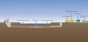
Pulling the pipe

Events: Protests and arrests
The construction of the pipeline through the Wet’suwet’en territory has been countered by on-going efforts by members of the Wet’suwet’en to defend their rights to govern the land. A heavy presence by the RCMP has contributed to many clashes and arrests. The following is a partial account of activities and outcomes, in chronological order.
Sources:
Events listed 2012 through 2019 are from the Supreme Court of BC decision to allow an injunction. Coastal GasLink Pipeline Ltd. v. Huson, 2019 BCSC 2264.
Details of more recent events are from various newspaper articles published in The Tyee, CBC News, and The Narwhal
| Early 2012 | Land defenders set up the Bridge Blockade across the Wedzin Kwa (Morice River) to prevent industrial development, including pipelines, in Unist’ot’en traditional territories. Also known as the Wedzin Kwa Checkpoint. Two gates were built, one on either side of the bridge. Several structures and cabins were built and referred to as the Unist’ot’en Camp, which is located near the confluence of the Wedzin Kwah and Gosnell Creek not far from the mouth of Morice Lake. Location: Unist’ot’en Camp, Morice West Forest Service Road |
| After 2012 | During early stages of the pipeline’s development, TC Energy attempted unsuccessfully to access the area on the far side (west side) of the Bridge Blockade to conduct field work in preparation of Section 8 of the pipeline. This work was required for planning and applying for permits. TC Energy worked around the Bridge Blockade in order to complete field work., rather than confronting the defendants and possibly escalating conflict. Province issues permits to TC Energy to use forest service roads, including Morice, Morice West, and Shea Creek. |
| 2018 | |
| December 14 | Supreme Court of BC grants an interim injunction to prevent Wet’suwet’en land defenders from blockading the Morice West Forest Service Road to prevent access to the area. |
| December 21 | Interim injunction revised to include all of the Morice FSR. The Bridge Blockade remained in place and fortified with a wooden barricade across the road, barbed wire, and a bus. |
| 2019 | |
| January 7 | RCMP attended the Bridge Blockade to enforce the Interim Injunction and diffuse tensions. The RCMP met with a group of Wet’suwet’en Hereditary Chiefs to discuss voluntary access beyond the Blockade, without success. The same day, the RCMP began to enforce the Interim Injunction with the aim to control the area. In response, Land Defenders ignited a large fire and felled trees across the road. Fourteen Land Defenders were arrested, but charges were vacated later. Access beyond the Bridge Blockade was impeded until January 11, 2019. |
| April 12 | Land Defenders at the Unist’ot’en Camp and TC Energy signed an Access Protocol Agreement. In spite of this agreement, more incidents and work delays followed. As well, “new resistance camps” were established in other areas within Sections 7 and 8. |
| March 2 | The Tsayu Land Defenders established a camp to stop TC Energy from conducting work in the territory of the Tsayu Clan. |
| May 29 | Land Defenders built a Healing Cabin on Crystal Creek Forest Service Road and directly in the path of the pipeline right-of-way. Ongoing incidents contributed to delays and increased costs to TC Energy. Activities of Land Defenders included the movement and removal of flagging for construction and environmental matters; entering the areas behind safety barriers; parking vehicles in front of heavy machinery; masked people driving a pickup truck into an active work site at a high rate of speed; intimidating behaviour or verbal harassment. |
| December 19 | Supreme Court of BC issues injunction prohibiting anyone from interfering with, stopping, or obstructing Coastal GasLink work activities. |
| 2020 | |
| February | The RCMP removed a series of Wet’suwet’en checkpoints. Dozens of Land Defenders were arrested. |
| February 29 | The Government of Canada, Government of BC, and Wet’suwet’en Hereditary Chiefs signed a Memorandum of Understanding (MOU). The MOU states that Canada and BC recognise recognize Wet’suwet’en aboriginal rights and title throughout the yintah and that these rights and title are held by Wet’suwet’en Houses under their system of governance. Under the terms of the MOU, an agreement was to be negotiated within twelve months. However, shortly thereafter, COVID protocols hindered the negotiations; it appears that negotiations remain on-going. The MOU does no address the CGL pipeline. After the MOU was signed, the RCMP interventions on Wet’suwet’en traditional territories have continued. |
| May 1 | The Elected Chiefs of the Wet’suwet’en Nations released a letter stating they “have not agreed to, nor have they given their support to sign, a proposed Memorandum of Understanding (MOU) on rights and title with Canada or British Columbia.” The Elected Chiefs expressed concern about not being consulted and that no vote was taken on the MOU. |
| August 15 | A cabin belonging to Chief Gisday’wa was destroyed by fire. The arsonists are unknown. |
| 2021 | |
| April 16 | The Province of BC announced it will provide $7.2 million over three years to the Wet’suwet’en Nation to support implementing rights and title in their territory. The three-year funding program will help support governance among Wet’suwet’en members and for water stewardship, wildlife programs, eco-system monitoring, other stewardship initiatives, and ongoing discussions related to the 2020 Memorandum of Understanding. |
| November 14 | After occupying a site along the Wedzin Kwa for 50 days, Land Defenders blocked the road into the territory. The Coyote resistance camp occupies Coastal GasLink’s drill site on the banks of the Wedzin Kwa River. Coastal GasLink workers were given 10 hours to leave, but most workers stayed. |
| November 17 | Police raided the resistance camp. The raid involved a canine unit, sniper rifles, and helicopters. Police used a chainsaw to gain access to a tiny house. Twelve land defenders and two journalists were arrested. |
| 2022 | |
| February 17 | Coastal GasLink security reported a violent confrontation with Land Defenders. |
| June 22 | Members of the Gidimt’en Clan of the Wet’suwet’en Nation filed a civil claim against the RCMP, the BC Minister of Justice, Coastal Gaslink Pipeline LTD., and private security contractor Forsythe. The claim alleges a campaign of surveillance, intimidation, and harassment. |
| September | Coastal GasLink says it “is in the process of completing trenchless watercourse crossings underneath the Morice River and Crocker Creek. |
| September 22 | CGL contractors destroyed an archeological site that is significant to preserving the cultural heritage of the Wet’suwet’en. |
| 2023 | |
| March 26 | A Coastal GasLink security worker files complaint with Police, alleging a group of people wearing masks and camouflage gained access to the work area, including vehicles. |
| March 29 | Five land defender arrested for obstruction of Police. Police were enforcing a search warrant for theft under $5,000 that occurred on March 26. |
31
LEARNING MODULE
Since 2010, the general impression of downtown Prince George is one of revival. Many new stores and restaurants opened with accolades to the city for its commitment to supporting downtown development. Amidst the positive developments, much went on behind the scenes by the City to ensure that projects were supported, approved, and implemented. And much more about the costs were revealed in local newspapers.
To support development of some of these projects, the City asked residents twice to approve long-term debt financing. In October, 2017, residents approved proposals for the City to borrow a $50 million for a new pool ($39 million) and new Fire Hall No. 1 ($15 million). In May, 2019, residents were asked to approve a proposal for the City to borrow $32 million to pay for 11 infrastructure projects (most of these projects were not downtown). Projects that took place downtown are identified in Figure 1 and described below.
Figure 1. Downtown developments in Prince George, since 2010.
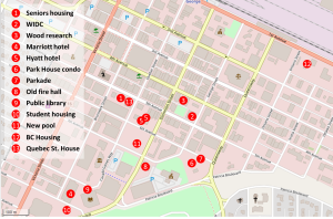
Source of base map.
A 36-unit seniors housing complex was built downtown at 1373 Sixth Avenue. When the Commonwealth Health Centre purchased the old gaming centre, it also became owner of the airspace above the underground parkade. As well, new owners also inherited an obligation to build multi-family housing in this airspace above the parkade. These arrangements were part of an agreement between the City and the previous owners of the gaming centre. This agreement is based on the city purchasing the parkade and, as part of this purchase, the owner had to build six townhouses.
The Wood Innovation and Design Centre (WIDC) is a six-storey wood-construction building. At the time it was built, it was the tallest wood building in the world. WIDC is the home of the Master of Engineering in Integrated Wood Design program for the University of Northern British Columbia.
The UNBC Wood Innovation Research Lab (WIRL) is an energy-efficient building located next to the WIDC. The new lab is a wood science and engineering research facility for the study of building tall, large-scale wood structures. WIRL includes a wood conditioning and processing room, a lab, and classroom space.
This development is a six storey, 174-room, hotel at Tenth Avenue and Brunswick Street, which includes a 3,600 square-foot space outfitted for a restaurant. The development was valued at $35 million and includes convention space, a pool, and underground parking
Six years earlier, in 2012, the initial project was based on a 12-storey hotel and luxury condominium. The proposed Delta Hotel was to have 151 hotel rooms, 34 condominiums, and a restaurant. After a foundation was laid, the site sat dormant for two years. “Construction started in September 2013 and then ground to a halt in March 2014. It took a $3.2-million cash infusion from the city, using money from a Northern Development Initiatives Trust fund, and a 10-year tax exemption to get work started again in July 2016.”1
In order to make the financial support work for the Marriott hotel development, some changes were required. Whereas a develop can apply for only the RTE or Early Benefit Program, there were not enough funds in the EBP program to cover the possible full value of the RTE. Consequently, the City asked NDIT to change the rules of the EBP program so that the two incentives could be combined to cover the full value.
The former Odeon Theatre on Vancouver Street was purchased and renovated ($1.7 million) to create a new community hall and conference centre for the Lheidli T’enneh. The facility offers full in house-catering. The name of the building is Uda Dune Baiyoh, meaning “House of Ancestors.”
The Hyatt Place Hotel is a 104-room modular building located at 585 Dominion Street.
Adding permanent residents to the downtown core has been a centrepiece of downtown revitalisation for more than twenty years. For this reason, the Park House residential development was hailed as a major accomplishment and turning point. Like other downtown projects, this development also required a partnership with the City and financial incentives.
The Park House development, built by with A & T Projects Development Ltd., was based on a four-phase development with four four-storey 160-unit condo buildings (Figure 2). The project has reduced to three buildings. The first phase, with 37 units, has been completed; the remaining phases will have between 32 and 46 units. The project includes underground parking (see next item) with electric-vehicle charging stations. When completed, the residential development will be home to 300 to 400 people.
This multi-family residential development was eligible for three financial incentives.
As shown in Figure 2, instead of a fourth condo building, the Park House development now includes space for a childcare centre to be operated by the YMCA of Northern BC. In December, 2020, the city received $3.98 million from the Childcare BC New Spaces Fund and a Union of B.C. Municipalities to build the 85-space childcare centre.
Figure 2. Proposed four-phase Park House development

The underground parkade for the Park House condominium project, located on Sixth Avenue near George Street, was built by A & T Projects Development Ltd. in partnership with the City. The City owns the parkade, which serves as the foundation for the residential buildings and provides 289 underground parking stalls and 62 surface parking spaces. The parkade is also the foundation for the proposed YMCA child care centre. As per the agreement, 133 of the underground parking stalls are reserved for condo residents at a discounted rate for 50 years. This parking subsidy is in addition to the incentives noted above for the residential development. According to the City Manager, the value of the parking subsidy is expected to be $95,000 per year or $4.75 million for the duration of the 50-year agreement.
The initial budget of the parkade was $12.61 million. The final cost was $22.46 million, which is 78% more than the expected cost. The cost over-runs were attributed to design changes and unexpected costs. The major design changes were related to ground water. Although it was fully known that the underground parkade is located in a flood zone with fluctuating ground water levels. After it was determined that the initial design failed to address risks to public safety and liability for possible damage, a permanent dewatering system was installed. The size of the parkade was also increased to cover the full parcel. Unforeseen costs include the following: increased construction costs for labour and materials; structural changes to the foundation; relocating a major fibre optic cable; removing several buried foundations and oil tanks; higher-than-expected costs for the roof waterproofing membrane; mechanical, electrical and fire suppression systems; retaining walls and fencing; and other expenses. When related projects are included, such as connecting the parkade to the city’s district energy system, upgrading water and sewer in the immediate area, the total cost of the project to the City was $34.16 million. These related projects were approved by Council in March, 2019, under a separate budget process.
In addition to the exceptional cost over-runs, members of City Council raised serious questions about staff authority to authorise the extra costs without Council approval and whether city staff misled Council about the true costs of the parkade. See Appendix A below for more details.
The City’s old and out-dated fire hall is located in the city’s downtown core near City Hall. However, this facility, which was built in 1956, was deemed inadequate to meet the city’s needs and plans were developed to build a new facility on the outside the downtown core, near the YMCA on Massey Drive near Carney Street. City residents approved $15 million debt financing via a referendum held in 2017. The development was completed at $2 million over budget, which was attributed to the need for a building larger than proposed to accommodate a fire dispatch centre and additional space in the mechanical room.
In May, 2019, City Council approved a $3.95-million budget for a new entrance at the downtown main branch of the Prince George Public Library. This amount is $1.28-million more than the initial cost in late 2017. In addition to increased construction costs for labour and materials, design changes included the following: an extra staircase; relocation of fire department connections; the elevator was extended to the upper floor; and the entry lobby was increased to 1.5 storeys. The final cost was $230,000 over the 2019 budget, pushing the total cost over $4 million.
A student housing development, with underground parking, was built at 1404 Patricia Blvd., next to the public library and the new Marriott Courtyard hotel. Construction started in 2019 with completion expected in summer 2021. Like the Park House condominium, this development is a key step toward downtown revitalisation by having more residents in the downtown area of the City.
The building is a six-storey, wood-framed structure with 205 units. The small units, described as self-contained “micro-units,” are less than 29 square metres (312 square feet). To accommodate this project, the City rezoned the parcel with special considerations. The project also qualified for the Downtown RTE and Multi-Family RTE.
Based on engineering reports, due to the age of the facility and its infrastructure, the old Four Seasons Pool required over $10 million in repairs and upgrades to meet current safety standards. Alternatively, the City proposed building a new pool at an estimated cost of $35 million. In October, 2017, residents approved the City’s proposal to borrow up to $35 million to build the new pool. The total cost of the project $39.1 million, which included the purchase ($4.5 million) and razing ($2.5 million) of the Days Inn hotel. Provincial and federal funding contributed $10 million. The Regional District of Fraser-Fort George contributed $750,000.
The new pool has the following features:
The new pool uses the Downtown Renewable Energy System to heat the pool, which reduces greenhouse gas emissions by 95 per cent compared to heating it with natural gas.
Construction started in July, 2020, and completed in fall 2022.
Canfor Corporation signed a five-year naming rights agreement for $75,000 per year.
There are two new BC Housing developments in the City’s downtown.
A residential development for social housing will be built at the corner of First Avenue and Ontario Street. The development will include 50 units of supportive housing and 50 units of rental homes for low-income people. Partners for this project include BC Housing, Northern Health, and the City. Northern Health will provide services including a needle exchange and safe injection site, community outreach and mental health services, and primary care for both residents and the public.
BC Housing purchased the National Hotel, located on First Avenue. The building was converted to 27 units of supported housing and opened to new residents in 2022. On-site staff will provide support services including meal programs, life and employment skills training, and health and wellness programs.
Quebec Street House is a four-storey, 36-unit apartment building. The units include bachelor, one- and two-bedroom units. As of February, 2023, the exterior of the building remains unfinished and the building is for sale.
This appendix refers to two news articles from the Prince George Citizen that are related to the cost over-runs of the Park House underground parkade. Both articles provide insights to the political process between Council and staff, as well as accountability.
Kurjata, Andrew. “A parkade has gone $22M over budget and it’s shaking up city hall in Prince George, B.C.” CBC News, January 14, 2021.
Williams, Arthur. “Mayor told of parkade cost increase in 2018,” Prince George Citizen. January 18, 2021.
32
LEARNING MODULE
This module addresses First Nation Reserve land tenures, which encompasses Indigenous people’s rights to land only under Canadian common law. The matter of Indigenous rights and title to land is separate, and addressed in other case materials and the Learning Module on Indigenous Title and Rights.
Reserve lands were created in accordance with the Indian Act (R.S.C., 1985, c. I-5). Under this Act, the use, control, and disposition of Reserve lands by Indigenous peoples are severely constrained. The issues with this state-controlled Reserve system are pronounced when compared to two other regimes that are available to First Nations, which are: (1) self-determined tenures under the Framework Agreement on First Nations Land Management (hereafter, Framework Agreement); and, (2) fee simple treaty settlement lands offered under the BC Treaty Commission Process. Collectively, the three regimes represent a continuum from limited property rights under the Indian Act to full property rights after treaty settlement.
Prior to European contact, Indigenous peoples determined territorial boundaries through a system of laws and customary rights. The extent to which property rights were practised and how formally they were managed varied significantly among Indigenous Nations across continent. Generally, customary rights were established usually through ritual and ceremony, and were enforced according to cultural practices and protocols. Customary rights are still practised today by many Indigenous peoples to grant and reaffirm private interest in areas of reserve land and traditional territory, and are increasingly recognised within Canadian legal and political realms. This particular nature of land use planning for Indigenous peoples demonstrates to Canadians that “the relationships that people have with land and with each other, concerning the acquisition, use, transfer and distribution of land and its products” are outcomes of negotiations. Indigenous land use planning also illustrates how the intricacies of land tenure and property rights creates many avenues for debate within negotiation processes and often leads to verbal, legal, and sometimes physical conflict among stakeholders.
The particular struggle of Indigenous peoples can be characterised as an ongoing effort to devise an equitable and ethical system of rights that satisfies both Western and Indigenous notions of communal and private property. In addition to customary rights, the result is a continuum of property ownership from less to more bundles of rights. As noted, this continuum ranges from state-controlled tenures of the Indian Act, to self-determined tenures under the Framework Agreement, to fee simple treaty settlement lands offered under the BC Treaty Process.
When considering the range of tenures available to Indigenous peoples, one must also consider “tenure security” and “transaction costs.” In conventional terms, tenure security has a strong association with legal title, that is, registration and protection under state law. This narrow view of legal title must be extended to include other forms of recognition, such as oral tradition, customs, and rituals, as well as resolutions enacted through traditional systems of governance. Security of tenure is also associated with duration, whereby there is the real or perceived expectation that tenure will continue without infringement or interference by others for the long term. Tenure security is also related to the right to reap benefits from the land or resource. Thus, a high degree of security implies little risk of the state or other claimants impinging upon another’s land rights. Correspondingly, a higher degree of tenure security is a foundation for investing in, conserving, and protecting property. Baxter and Trebilcock highlight these aspects of tenure security, as well as some related issues, as follows.
Where some of the community’s goals are to use resources more efficiently and to promote growth by participating in national and international economies, harmonizing land tenure inside the community with regimes outside and enforcing rights at the level of the state may provide greater tenure security for interest holders and produce net economic benefits. However, these reforms may entrench inefficient regimes, undermine traditional tenure systems, pose serious threats to community cohesion and fail to consider crucial supporting institutions, thus creating greater uncertainty and diminishing prospects for community-led development.
The term transaction cost describes the administrative burden incurred when dealing with property rights through the legal system, including financial and non-financial costs, as well as time. Both tenure security and transaction costs influence how one weighs the advantages and disadvantages of holding interest in lands.
The Indian Act was enacted in 1876. Although amendments have been made since its inception, the tenets of the legislation remain intact. Among Indigenous peoples, the Act is viewed as a form of discrimination and paternalistic oppression that regulates their lives. Among other things, the Act imposed band councils as the only legally-recognised form of governance and restricted traditional cultural practices.
The Indian Act is also the primary legal mechanism of the Government of Canada for enforcing power over all “Indians and Lands reserved for the Indians” (s. 91(24) of The Constitution Act, 1867). As stated in Section 20(1), “no Indian is lawfully in possession of land in a reserve unless…possession of the land has been allotted to him by the council of the band.” However, the lawful possession of land by individual band members provides few property rights under the reserve tenure regime of the Indian Act. Legally, First Nations possess usufructuary rights, which refers to the right to use and enjoy the property of another (the Crown), provided its substance is neither impaired nor altered.
For Reserve lands, band councils may grant possession of an on-reserve land parcel to a band member through either customary rights or a Certificate of Possession. It must be noted, however, that all formal band council decisions are subject to approval by the Federal Minister of Crown-Indigenous Relations and Northern Affairs Canada (CIRNAC), an arrangement that can make on-reserve land development a protracted and difficult process. If a band council adopts a Land Code, in accordance with the Framework Agreement and Framework Agreement on the First Nations Land Management Act (S.C. 2022, c. 19, s. 121), it can operate much like a municipal government and exercise authority over many aspects of land management, including the granting of possessory rights, zoning, and subdivision regulations, as well as processing development applications.
Since the Crown retains legal title to Reserve land, all Reserve lands are inalienable. This means that the land cannot be sold and can only be bequeathed to band members. Similarly, land obtained through customary rights cannot be leased to outside parties, mortgaged, or used as collateral for a loan. However, Section 38 of the Indian Act does permit a band to “surrender” all rights and interests in a property to the Crown or to “designate” land for the purpose of establishing a leasehold interest. This provision helps to use this land as collateral to get financing from off-reserve institutions, since lands surrendered in this manner may be seized in the event of a loan or mortgage default. However, since leasehold administration is conducted directly through CIRNAC with the leasee, the potential exists for disagreement between a land user and the Crown over specifics of the contract.
One method an individual band member can acquire interest in property is through customary rights, which are established through a range of traditions and practices unique to each band. The administrative systems for managing customary rights may range from informal, socially-determined mechanisms to those that are “highly structured with detailed, explicit rules regarding land use, value appropriation, title transfer and inheritance, and the initial allocation of rights by a central authority.”4
Once granted customary title, an individual user may occupy a parcel of land so long as the land use remains consistent with the wishes of band council. For example, a band member granted customary possessory rights may be enabled to build a home, operate a business, or cultivate the land for agricultural purposes. However, in cases of dispute, most courts have prioritised communal customary interests in Reserve lands over an individual member’s customary rights. Since customary rights are not legally recognised under the Indian Act, a land user has no mechanism for appeal. Thus, depending on the nature of the property and the member’s relationship with council, the land user may be subject to significant tenure insecurity.
There are some transaction costs associated with customary rights. With regard to the Indian Act, ministerial approval is rarely obtained since customary rights are not legally recognised. To remove timber or minerals from properties occupied under customary rights, the land user must apply to the Minister and pay the band for a temporary permit. The revenue from these transactions is collected communally as “Band moneys” and may only be spent with the Minster’s approval.
A band member who is in lawful possession of land (i.e., under section 20(1), approved by the council of the band) and wishes to increase tenure security may apply for a Certificate of Possession (CP) under section 20(2) of the Indian Act. A CP provides lawful “evidence of his [the successful applicant’s] right to possession of the land,” thus providing an individual member with use and possession rights, but not title to the land itself. In these terms, CPs are closest to, but fall short of, fee simple ownership on Reserve lands. A CP holder has the right to build a home on the land, extract resources from the land, and lease the land to another band member or non-member. A CP holder is not able to mortgage the property or use it as equity for a business venture.
A land user who obtains a CP from the Minister may be more likely to invest in the land and its buildings, since (a) risk of appropriation is greatly reduced; (b) ministerial and/or council approval of entrepreneurial activities is likely not required; and (c) profits from land use (through leases to third parties, primarily) are retained by the CP holder. Land held under a CP can also be used as collateral for a loan from the Band.
Notably, a land user is not permitted to transfer or subdivide a CP to non-band members; however, under section 58(3), the federal government may establish long-term leases for CP land with non-members or corporations, effectively selling the property. This latter arrangement does not require consent from band council and is obtained directly through CIRNAC. Nonetheless, the reserve tenure system may serve as a disincentive to outside investors.
Acquiring a CP involves considerable transaction costs. Resolution by a band council and approval by CIRNAC may take anywhere from 6 months to 11 years. Transfer applications to other band members are also burdened in this manner.
The Framework Agreement on First Nations Land Management, agreed upon in 1999, represents a government-to-government initiative to improve Indigenous governance through the development of self-determined Reserve land management regimes for each participating band council. This agreement allows for the transfer of administration and control over land management (but not Indigenous title) from CIRNAC to a band council. In effect, the Framework Agreement strengthens the communal (or collective) rights of participating bands and is a step toward developing culturally appropriate on-reserve land tenure regimes. In collaboration with its members, a band council is empowered to decide through which tenure regime land users, both members and non-members alike, may occupy, manage, transfer, and profit from Reserve properties.
The transfer of administration and control is accomplished through the creation of a Land Code, which replaces specific land-related provisions of the Indian Act. As of 2020, 96 band councils across Canada have an operational agreement, with 48 agreements under development.
Section 6(1) of the Framework Agreement outlines the requirements for adoption of a Land Code, including a legal description of the land that will be subject to the Code. The Land Code includes the rules and procedures governing a range of land uses and associated rights, such as the following:
The Framework Agreement contains a number of other sections relevant to Reserve land use planning, including the following:
Prior to ratification of its Land Code, band councils must complete an Individual Agreement, also known as a Transfer Agreement, with the Government of Canada. This agreement details the transfer of Federal interests and administrative duties to a band, and the financial resources required to capably administer these new jurisdictions. Upon member ratification of this agreement and the Land Code, a band acquires full legal powers to manage all its lands and resources as outlined in the Framework Agreement.
Tenures issued under this regime will be registered in the First Nations Land Register, which is administered by CIRNAC. A participating nation may also choose to create their own on-reserve registry system that duplicates information provided to the federal land register.
Under the Framework Agreement, all Reserve land continues to be held in trust by the Crown, thereby prohibiting outright transfer of title to non-members. Nonetheless, outside investment may be enticed by reduced transaction costs, where Ministerial approval is no longer required for land use arrangements.
Given the stipulations for member approval and a formalised lands registry, it may be assumed that tenure security for individual band members will be improved under the Framework Agreement. Furthermore, tenure security is increased by allowing council or land users to negotiate lease contracts directly with third party lessees, a power not afforded under the Indian Act. However, imprecise or vague language employed when drafting a Land Code may actually decrease security for land users when compared to the more firmly entrenched CP system. Furthermore, the variability of self-determined tenures makes analysing the security of property rights of individual land users more complicated.
While the Framework Agreement represents a significant step towards developing culturally appropriate Reserve land tenure regimes, the rights of Indigenous peoples remain subsumed under s. 91(24) of the Constitution Act, 1867 and the largely archaic Indian Act. This restriction on land tenure persists under the Framework Agreement because the adoption of a Land Code has no bearing on title. In other words, as stated in the Framework Agreement, the land management agreement is not a treaty or land claim.
Three issues regarding the Framework Agreement should be noted. The first is the cost of administering a land code, which requires time and expertise. Some funds are provided initially to support administration, but bands have stated that the funding is inadequate. Second, these costs include environmental assessments and land surveys. Liability is another major concern. Under their own land code, a band assumes legal and financial responsibility for everything that happens on their land, including disasters and problems. Given these issues, as Flanagan and Alcantara note, the options afforded under the Framework Agreement appears, in some respects, to be a process of the federal government devolving some responsibilities to band councils.
Sharlene Jobin and Emily Riddle offer a harsher critique. While not rejecting the Framework Agreement outright, Jobin and Riddle express strong concern that the Framework Agreement must be viewed as part of a larger context of colonisation and alienation. They state,
In our view, as treaty people, the threat of the First Nations Land Management Regime is that it overwrites our treaty history and obligations. Beyond this, for people whose nations do not have historical or contemporary treaties with the Crown, the threat of the politics of distraction is also at play in that we believe we should be having a larger, more robust conversation with the Crown regarding jurisdiction and management of lands and resources in Canada. It is important to state at the outset that the Indian Act, the First Nations Land Management Act, and the Framework Agreement on First Nation Land Management make no substantive reference to treaties. This regime is about a very limited type of self-governance and does not substantively implement the self-determination envisioned by our ancestors through treaty or inherent rights. (p. 5)
Jobin and Riddle characterise the Framework Agreement as a process of “Reserve marketisation.” They argue that the First Nations Land Management Act prioritises economic development, thus favouring First Nations with aligned interests. “Ultimately, the aim of the First Nations Land Management Act is to put reserve land on the global market, subjecting communities to increased market forces” (p. 6). The effect is to serve economic interests at the expense of Indigenous philosophy, practices, and lands.
Fee simple is the highest estate a land user may be granted in Canada. Title holders may exercise the fullest extent of property rights afforded under Canadian law (subject to legislation, taxation, Crown reservations and/or any stipulations on the deed or certificate of title). Thus, land users may enjoy a high degree of tenure security and minimal transaction costs associated with their property. For these reasons, some argue that fee simple title is best suited to empower Indigenous peoples to “define their relationship with the land as they wish,” with minimal risk of interference or expropriation from government or other claimants. Furthermore, the self-governing authority and law-making power of a treaty allows Indigenous peoples to ensure cultural values are enshrined within an appropriate legal framework.
In British Columbia, the process for formalising fee simple rights and title to land is established through a six-stage negotiation process administered through the BC Treaty Commission. While the specific details of provincial treaties are unique to each Indigenous Nation, each treaty will normally include common provisions such as:
For these provisions, some advocates describe the BC Treaty Process as fundamentally distinct from past attempts at enfranchisement in that, rather than take away status, the self-governing authority and law-making power of a treaty allows Indigenous Nations to ensure cultural values are enshrined within an appropriate legal framework.
As an example, the Nisga’a in the Nass River Valley sought and ratified a unique treaty agreement in 2000, which contains provisions for self-government and fee simple ownership.11 For the Nisga’a, the treaty established a “modified” form of title to land, which included areas of land dedicated as Nisga’a Lands (communal lands) and Nisga’a Fee Simple Lands. The Nisga’a Fee Simple Lands refer to 33 sites located outside of Nisga’a Lands. Eighteen of these sites are former reserve lands, to which the Nisga’a have close to full fee simple tenure (referred to as Category A lands), which includes full rights to subsurface resources, i.e., minerals. Fifteen sites are located elsewhere with limited fee simple tenure (Category B Lands). The treaty established the authority of the Nisga’a Government to make laws dividing property and regulating activities.
In its annual report for 2022, the BC Treaty Commission identifies 39 First Nations involved in the BC treaty process (Figure 1). Seven First Nations are implementing modern treaties; 31 First Nations are actively negotiating at different stages of the process. The Nisga’a Treaty was negotiated prior to the BC Treaty Commission process.
Figure 1. Map of First Nations involved in the BC Treaty Commission process
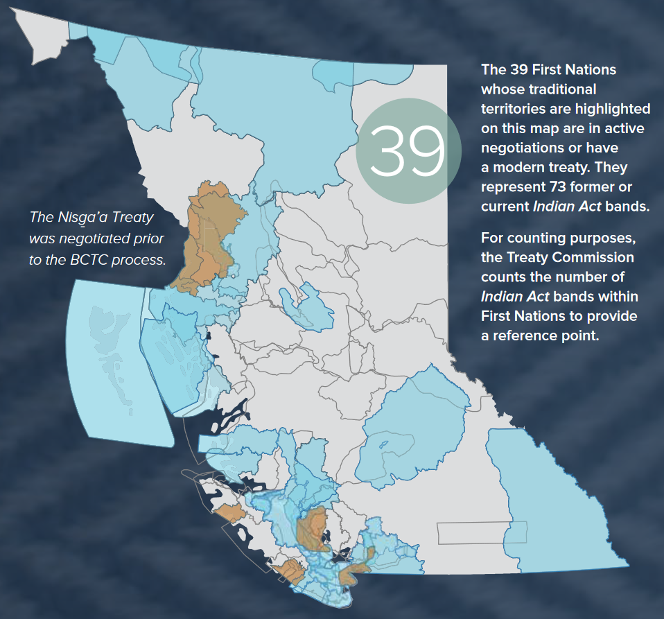
Source: BC Treaty Commission (2022). Annual Report 2022.
Despite the many apparent freedoms offered under fee simple estate, a debate exists whether or not freehold tenure is desirable for Indigenous peoples. In the United States, the much maligned Dawes Act (1888) enforced private interests through fee simple ownership of Reserve lands upon Indigenous peoples. The campaign was a failure, with hindsight suggesting that private land holdings “actually increased poverty rather than reducing it” by providing non-Indigenous speculators with the legal mechanisms to purchase Reserve lands. For similar reasons, some argue that fee simple title would fundamentally alter the relationships between Indigenous peoples and their lands. This perspective was reinforced by the Assembly of First Nations’ rejection of the proposed First Nation Property Ownership Act (POA).
The First Nations Tax Commission, a Federally-legislated body, proposed the POA in 2009. In their rejection of the POA, the Assembly of First Nations argued that:
In contrast, the First Nations Property Ownership Initiative, a group, argued in favour of the POA because it would allow Indigenous Nations to transfer title of lands from the Federal Government to Indigenous Nations and to issue fee simple title.
The debate about fee simple rights transcends arguments about the advantages and disadvantages of this tenure. As reflected in the landmark Supreme Court of Canada case, Delgamuukw v. British Columbia (1997),
‘Aboriginal title’ is based on the continued occupation and use of the land as part of the Aboriginal peoples’ traditional way of life. This sui generis interest is not equated with fee simple ownership; nor can it be described with reference to traditional property law concepts.
Fundamentally, the debate strikes at the heart of ‘tenure formalisation,’ about whether or not the Western system of land tenure and property rights is compatible with Indigenous concepts of ‘ownership,’ and about the possibility of an equitable and ethical system of rights that satisfies both Western and Indigenous notions of property.
33
This Learning Module describes lands designated as parks and other protected areas by Indigenous Nations, which is one of two distinct perspectives on protected areas in British Columbia (BC). The other distinct perspective is protected areas designated under BC legislation, which is covered under a complementary Learning Module.
The primary source of information presented in this module is the following report produced by the Indigenous Circle of Experts. All page references herein are to this report, unless indicated otherwise.
The Indigenous Circle of Experts was formed to contribute to Canada’s goal, the Pathway to Canada Target 1, to protect at least 17% of terrestrial areas by 2020. Members of the Indigenous Circle of Experts include a core group of Indigenous experts from across Canada in collaboration with representatives of federal, provincial, and territorial jurisdictions. The We Rise Together report by Indigenous Circle of Experts presents recommendations to promote greater recognition and support for existing Indigenous rights, responsibilities, and priorities in conservation. The report also provides guidance to Indigenous, provincial, territorial, and federal governments about legal mechanisms to formally recognise and establish Indigenous-led protected areas. As the report states, “An Indigenous government’s decision to establish an IPCA [Indigenous Protected and Conserved Area] is an assertion of sovereignty, and should be responded to on a Crown-to-Indigenous government basis.”
The term “Indigenous Protected and Conserved Areas” (IPCAs) is used by the Indigenous Circle of Experts to encompass different approaches and outcomes of Indigenous-led conservation efforts. As stated in the report,
Different terms may be used to describe initiatives by Indigenous governments and communities to assert their stewardship for their territories and areas. Examples are Tribal Parks, Indigenous Cultural Landscapes, IPAs [Indigenous protected areas] and Indigenous conserved areas. For the purposes of this report, ICE [Indigenous Circle of Experts] has adopted the term Indigenous Protected and Conserved Areas, or IPCAs, to describe these types of initiatives in the Canadian context.
The aim is to develop new Indigenous-led protected and conserved areas. By definition, IPCAs “are lands and waters where Indigenous governments have the primary role in protecting and conserving ecosystems through Indigenous laws, governance, and knowledge systems.” By this definition, IPCAs do not include protected areas known as Conservancies, which are lands designated under BC’s Parks Act (refer to Learning Module. Parks and Protected Areas).
In the remainder of this Learning Module, and drawing from the We Rise Together report, we cover characteristics and governance of IPCAs. In addition, we reproduce brief descriptions of BC-based IPCAs.
Based on their review of existing IPCAs, both in Canada and elsewhere, the Indigenous Circle of Experts identified three essential elements that characterise IPCA governance and management, as follows.
IPCAs are Indigenous-led
Indigenous governments have the primary role in determining the objectives, boundaries, management plans and governance structures for IPCAs as part of their exercise of self-determination.
There may be a range of partnerships to support these acts of self-determination, including with Crown governments, environmental NGOs, philanthropic bodies, or others.
IPCAs are, in essence, Indigenous-led conservation initiatives that reflect the objectives and needs of their respective nations or governments and emerge through transparent negotiations.
IPCAs represent a long-term commitment to conservation
Indigenous Peoples take a multi-generational view of stewarding their territories. Therefore, an IPCA represents a long-term commitment to conserve lands and waters for future generations.
IPCAs elevate Indigenous rights and responsibilities
Indigenous Peoples have long-standing physical and spiritual relationships with the lands and waters within their respective territories, and with the natural cycles that determine their use. These relationships have always included the right to benefit from the bounty of the natural world and the reciprocal responsibility to care for and respect the land and water, consistent with natural and Indigenous law, for future generations. In IPCAs, Indigenous Peoples’ continued relationship with the land and water must be assured by acknowledging the authority that Indigenous governments have to work with their people on how to use the land and water while achieving conservation and cultural objectives.
In addition to the above essential elements, the Indigenous Circle of Experts also identified a set of characteristics of what IPCAs might look like in Canada. The following list of characteristics of IPCAs is not intended to be prescriptive or exhaustive, as the priorities and objectives of IPCAs may vary greatly depending on the needs and objectives of the area.
As emphasised by the Indigenous Circle of Experts, IPCAs exist in stark contrast to the historical harms caused by the creation of protected areas under provincial and federal governments—without the consent of Indigenous Nations. “For Indigenous Peoples, the history of protected areas in Canada, while somewhat improved in recent times, has been fraught with rights violations, forcible displacement, loss of access to traditional territories and resources, and other substantial inter-generational cultural, social, economic and spiritual impacts.”
The Indigenous Circle of Experts describe a spectrum of partnership models that support Indigenous governance, management, and operational responsibilities of IPCAs. Potential IPCA partnerships models include the following:
Indigenous Government–Crown Government partnerships
This model emphasizes Indigenous and Crown governments (including federal, provincial, territorial or municipal) working in partnership, cooperation and agreement to recognize, establish and/or manage a protected area.
Indigenous Government–non-governmental partnerships
This model is based on partnerships between Indigenous governments and non-government partners. Such partners could include industry, land trusts or conservation organizations. Often, this model is conducive to the acquisition of private properties for conservation purposes.
Hybrid partnerships
In this model, multiple parties (government and non-government) work collaboratively to resource and manage protected or conserved areas. The model requires all parties to play a clear role in building a successful collaborative approach.
Sole Indigenous governance
In this model, Indigenous governments make unilateral decisions and manage lands (e.g., Treaty lands, reserves, Aboriginal title, etc.) for protection or conservation purposes.
Throughout the We Rise Together report, the Indigenous Circle of Experts highlight examples of IPCAs from across Canada. Below, we have reproduced the “snapshots” of BC examples.
SNAPSHOT: HAIDA GWAII PROTECTED AREAS
“Protected areas” is the term agreed to by the Council of the Haida Nation (CHN) and the Province of British Columbia for 18 protected sites. The areas consist of seven older parks and ecological reserves (established prior to modern agreements and with little Indigenous involvement or consultation) and 11 newer sites (established through government-to-government agreements). The Haida recognize the 18 sites as “Haida Heritage Sites” and manage them by way of Haida Stewardship Law. The province recognizes the sites as parks (two sites), ecological reserves (five sites) or conservancies (11 sites) as defined by the Park Act. As there is no formal recognition of the designations each government uses by the other government for the sites, “protected areas” is the common or generic term. Prior to achieving protected area status, the 11 conservancies were considered at risk for resource extraction and impacts to important cultural sites and species. Today, all 18 protected areas are managed collaboratively and with respect to Indigenous rights. The 18 protected areas together comprise 332,992 hectares of upland and 169,652 hectares of marine foreshore, totalling 502,644 hectares.
SNAPSHOT: DASIQOX TRIBAL PARK (NEXWAGWEẐɁAN)
Dasiqox Tribal Park (DTP, known as NexwagweẐɁan, which means “it is there for us”) is an Indigenous-led protected area located in traditional Tsilhqot’in territory in the south-central interior of British Columbia. It covers approximately 300,000 hectares of wilderness, wildlife habitat and waters. Protection of the area through Indigenous governance was initiated in 2014 by the Xeni Gwet’in and Yunesit’in governments who represent the Tsilhqot’in. DTP connects a number of existing parks and protected areas across a large area at the heart of Xeni Gwet’in and Yunesit’in caretaker areas, including the Dasiqox headwaters, an essential water source for the area’s waters, fish, and wildlife.
DTP is a tangible expression of reconciliation that provides its people with a historic opportunity to redefine their relationship with their non-Indigenous neighbours in the region. By establishing it, the Tsilhqot’in asserted their rights and responsibilities as caretakers working to protect the ecological health, cultural revitalization and sustainable livelihoods of its people.
The Tsilhqot’in use three themes to organize their management of the park: ecosystems, culture, and sustainable livelihoods. They recognize that these themes are inseparable and interconnected, but feel it is important to name them in order to remain accountable to them in governance decisions and management practices. Over time, as the Tsilhqot’in’s capacity grows, they may decide to expand the Tribal Park to include a larger area.
SNAPSHOT: TLA-O-QUI-AHT TRIBAL PARKS
At the heart of the Clayoquot Sound UNESCO Biosphere Reserve on the West Coast of Vancouver Island British Columbia in Canada, a new model of Tribal Parks is emerging as a global example of social-ecological resiliency. The Tla-o-qui-aht have conceived an Indigenous Watershed Governance methodology that is a model of sustainable livelihoods and promotes environmental security. The keystone of this methodology is a conception of humanity that orients individuals within a rich social contract that extends ideas of justice to the environment.
But it was not always this way. Over the years from 1914 to 1984, the Tla-o-qui-aht began with polite protests and advanced to direct action in the form of blockades and litigation against the BC provincial government, which had condoned the clear-cut logging of ancient cedar rainforests on Meares Island.
In 1984, Tla-o-qui-aht Ha’wiih (heritary chiefs) declared Meares Island a Tribal Park in response to unsustainable logging practices that were impinging on traditional territories. From 1984 to 2014, the Tla-o-qui-aht moved from setting up blockades to pioneering Tribal Parks as an alternative to the business-as-usual approach to natural resource management. Since then, they have established three more Tribal Parks (collectively known as the Tla-o-qui-aht Tribal Parks): Ha`uukmin (Kennedy Lake Watershed), Tranquil Tribal Park, and Esowista Tribal Park.
The Tla-o-qui-at vision is to re-establish a healthy integration of economy and environment. Its aim is to establish a Tribal Parks administrative organization and develop the governance tools needed to operate Tribal Parks as well as to initiate and partner in business opportunities that promote sustainable livelihoods.
SNAPSHOT: K’IH TSAA?DZE TRIBAL PARK, DOIG RIVER FIRST NATION
Doig River First Nation (DRFN) is a Treaty 8 Nation with traditional territory extending from its reserve land in British Columbia across the provincial border into northwestern Alberta. In 2011, it announced it was establishing K’ih tsaa?dze Tribal Park—an area covering almost 96,000 hectares—to protect the area from the impacts of forestry and oil and gas development. (K’ih tsaa?dze means either “spiritual healing area,” or “old spruce.”) The Alberta portion is managed as public Crown land, but DRFN would like it to see it designated a Wildlife Provincial Park. The First Nation has expressed interest in co-management models as well as an openness to tourism. According to DRFN, K’ih tsaa?dze has been a sacred and spiritually significant area for generations, and a space used both for exercising Treaty and Aboriginal rights and for teaching traditional practices and knowledge to youth. It also contains medicinal plants and old-growth forest.
SNAPSHOT: THE GREAT BEAR RAINFOREST AGREEMENTS
The Great Bear Rainforest represents a quarter of all remaining coastal temperate rainforests on the planet. This magnificent region of old-growth forests, grizzly bears, black bears, rare spirit bears and salmon is home to Indigenous communities thousands of years old. Some 6.4 million hectares in size, it stretches along British Columbia’s west coast from the Discovery Islands to the Alaska border.
Until recently, its cultural and ecological heritage was threatened with industrial-scale logging. The situation finally began to improve in the mid-1990s, when environmental NGOs stood with the Nuxalk (who have shared territory in the area with Heiltsuk First Nation) to blockade logging companies. Arrests, protests, and the targeting of investors and consumers buying products from the area fuelled international media attention and forced the province to take First Nations’ concerns seriously.
A turning point came when involved environmental NGOs formed the Rainforest Solutions Project (RSP) while stakeholder companies formed the Coast Forest Conservation Initiative (CFCI), and following difficult negotiations, both agreed to work together as the Joint Solutions Project advising First Nations and the BC government on solutions to unsustainable logging.
Shortly thereafter, all parties agreed to an independent scientific panel, the Coast Information Team (CIT) to come up with recommendations on how to ensure the socio-economic and ecological well-being of the region and its peoples. In 2004, CIT called for 70 percent of the region’s natural levels of old-growth ecosystems to be protected. This would still allow for a viable forestry sector by implementing a coast-specific forest management regime called Ecosystem-Based Management (EBM).
The proposed solutions led the provincial government to announce the breakthrough Great Bear Rainforest Agreement in 2006: a comprehensive protection and social well-being package for the region, which was now permanently defined as the south, central and north coasts of BC and Haida Gwaii. The result was that 33 percent of the region would be off-limits to industrial logging through a new form of protected area called a conservancy (which was more inclusive of First Nations uses, unlike previous designations; see below), with EBM protecting another 37 percent. Additional funding was secured from the philanthropic sector.
But by 2009, all parties had realized that that this ambitious level of protection was going to be impossible to reach: only 50 percent protection had been achieved by then, and First Nations had not felt enough social or economic improvement. All parties agreed to another five years of negotiations.
At last, in 2016, the Government of British Columbia announced that a final agreement had been reached to protect 85 percent of the forested land base of the Great Bear Rainforest from industrial logging, with stringent legal logging regulations to be applied to the remaining 15 percent. The Agreement recognized and enshrined shared decision-making between the Government of British Columbia and First Nations for land use within the region. It also provided increased economic shares of timber rights and new measures to nurture a conservation economy, with additional funding for the region’s First Nations.
There continues to be challenges with the Agreement, such as a less-than-ideal level of Indigenous government decision-making over their territories; however, it is exponentially better than the previous status quo. Furthermore, this model has been studied throughout the world as it has provided many lessons gleaned given its innovative multi-lateral large-scale land use planning processes which centred on both Indigenous rights and ecological imperatives.
CASE STUDY: CONSERVANCIES IN BRITISH COLUMBIA
Conservancies were introduced in British Columbia in 2006 as a new designation of protected areas after negotiations with First Nations related to land use planning and reconciliation on the coast of BC. Historically, some First Nations had raised concerns that parks or ecological reserves did not fully allow for Indigenous social, ceremonial and cultural uses, and that there was a history of restrictions being imposed on the land without First Nations agreement or Treaty (beginning in 1911 with the province’s first provincial park).
Key to negotiations in the 2000s with First Nations and coalitions of First Nations (e.g., Coastal First Nations, Nanwakolas Council), if there were to be any new forms of protected areas, was provincial recognition that biodiversity protection and Indigenous uses were intertwined. In addition, such a new designation would provide for a greater range of low-impact, compatible economic opportunities that could contribute to socioeconomic objectives for First Nations.
In 2006, the Park Act was amended to authorize the establishment of conservancies with the following criteria:
Conservancies prohibit commercial logging, mining and hydroelectric power generation other than local run-of-the-river projects. Of the 1,033 protected areas in BC, 156 are conservancies protecting 2,998,504 hectares of upland and foreshore areas.
Most conservancies fall within Indigenous territories (many in shared territories) for which Indigenous governments have signed either broad reconciliation agreements with the province or collaborative management agreements with BC Parks.
Developing and approving management plans jointly by both the Indigenous and provincial government representatives is a key management strategy. Based on community consultation the plans provide in-depth descriptions of the importance of an area to Indigenous Peoples and provide direction for preserving and maintaining the use of the area for social, ceremonial, and cultural purposes. Plan approval by the governments is critical, given that in 2006, the provincial government (with support from First Nations) committed that no new uses in conservancies would be allowed (permitted by the statutory decision-maker) until approved management plans were in place.
Following plan approval, and in the spirit and intent of reconciliation, the governments work together toward consensus-based decision-making, including making operational decisions for implementing management plans.
While conservancies are a step in the right direction toward greater say by First Nations over how their territories are managed and where they are located, conservancies are neither co-governed nor co-managed because the provincial government still has discretion over whether conservancy management plans put forth by First Nations governments are approved. As a result, some plans may go through many iterations, consuming scarce First Nations government resources. In addition, resourcing of planning, implementation and evaluation of management plans are a challenge with neither the provincial government nor First Nations governments able to properly resource them, often leading to generic plans being developed and approved rather than place-based ones.
Accordingly, the success of the conservancy model lies in the timely and efficient development of management plans that meet the needs of First Nations and the provincial government, with provincial recognition that, depending upon capacity, First Nations should both be driving the development of frameworks for management plans at the community level and should have an increasing role in the plan approval process.
SNAPSHOT: WILP WII LITSXW MEZIADIN INDIGENOUS PROTECTED AREA
The Wilp Wii Litsxw Mezidian IPA was established in August, 2021, by the Gitanyow Nation. The primary aim of this IPCA is to protect 54,000 hectares of sockeye salmon habitat in the Kitwanga and Nass River watersheds, as well as along sections of the Kispiox River. In spite of past efforts to work with the provincial government to establish a conservancy, the Gitanyow were concerned that industrial activities, especially mining, had compromised the salmon habitat. When continued efforts working with the province to expand the conservancy did not produce results, the Gitanyow took the initiative to establish the IPCA. The Wilp Wii Litsxw Meziadin protected area does not restrict industrial activities and the Gitanyow appreciate the economic benefits mining and logging. The purpose of the protected area is to better manage these activities to minimise harm to the watersheds and sockeye salmon populations.
34
LEARNING MODULE
In this learning module, we introduce a basic understanding of Indigenous rights and title primarily through a conventional lens of land use planning. Importantly, rights and title to land have different meanings when considered through Indigenous culture and customs.
It is important to think critically about how the foundations of Canadian law impose a way of thinking about land that is not consistent with, and can undermine, an Indigenous perspective of and relation with land. A good example of this inconsistency is the matter of boundaries among traditional territories. Canadian property law is predicated on clear demarcations between mine and yours, between inside and outside. These demarcations are expressed as boundaries as if drawn physically on the land itself.
In contrast, the relation of Indigenous peoples with land is inseparable from their way of being—their worldview, culture, and spirituality. Land is not something that is “owned” or “occupied.” Rather, Indigenous people’s are caretakers of land and water.
The following on-line resources provide an Indigenous perspective on Indigenous title and rights.
Based on Indigenous legal systems, Indigenous rights derive from elements of distinctive practices, customs, and traditions of an Indigenous Nation. From a common law perspective, Indigenous rights to land are articulated as unique property rights. Such rights include the right to access and use land for hunting and trapping. These rights are sui generis. That is, they are recognised as existing prior to the European assertion of sovereignty and to the establishment of property rights under common law in Canada. Indigenous rights are a claim recognisable, protected, and enforceable by Canadian common law.
Indigenous title is a form of property right specific to land; it is a sub-set of Indigenous rights. Indigenous title, like other Indigenous rights, is a special right recognised as sui generis. In other words, Indigenous title to land is not derived from Canadian law. An Indigenous right (to hunt, for example) can exist independently of Indigenous title to land.
Indigenous rights to land were recognised by the Crown in the Royal Proclamation of 1763 and in subsequent court decisions (see below). The Constitution Act, 1982 (s. 35(1)) affirms “existing Aboriginal and treaty rights.”
Like other property rights under common law (but not the same as), Indigenous rights to land correspond to their occupation, use, and control of ancestral lands. Indigenous rights to property, under the Constitution Act, 1982, do not include disposition rights. Indigenous people cannot sell rights to their land; they can only voluntarily surrender their land to the Crown through agreements (e.g., treaties). Also, Indigenous rights and title to land are often recognised as communal; they are not held by any individual Indigenous person but by Indigenous Nations.
See Box 1 (below) for a detailed description of Indigenous title to land, as described by the Nisga’a Tribal Council.
Section 35 of the Constitution Act, 1982, presented below, recognises and affirms Indigenous rights. However, the Constitution does not define what is included among these rights. Consequently, defining what Indigenous rights are recognised by the Constitution is an on-going matter before the courts, as evident in the following cases. Likewise, precisely how Indigenous title and rights are reconciled with the Crown’s assertion of title are also the subject of legal debate and have yet to be fully clarified.
Indigenous rights were formally entrenched in Canadian law through the Constitution Act, 1982. Section 35 addresses the “Rights of the Aboriginal Peoples of Canada,” as follows.
Recognition of existing aboriginal and treaty rights | 35. (1) The existing aboriginal and treaty rights of the aboriginal peoples of Canada are hereby recognized and affirmed. |
Definition of “aboriginal peoples of Canada” | (2) In this Act, “aboriginal peoples of Canada” includes the Indian, Inuit and Métis peoples of Canada. |
Land claims agreements | (3) For greater certainty, in subsection (1) “treaty rights” includes rights that now exist by way of land claims agreements or may be so acquired. |
Aboriginal and treaty rights are guaranteed equally to both sexes | (4) Notwithstanding any other provision of this Act, the |
Commitment to participation in constitutional conference | 35.1 The government of Canada and the provincial governments are committed to the principle that, before any amendment is made to Class 24 of section 91 of the “Constitution Act, 1867“, to section 25 of this Act or to this Part, (a) a constitutional conference that includes in its agenda an item relating to the proposed amendment, composed of the Prime Minister of Canada and the first ministers of the provinces, will be convened by the Prime Minister of Canada; and (b) the Prime Minister of Canada will invite representatives of the aboriginal peoples of Canada to participate in the discussions on that item. |
These detailed descriptions are from a booklet the Nisga’a Nation produced for its members to help understand the contents of their Treaty. The information in the booklet is presented in a question-answer format.
What are the basic features of aboriginal title?
Some of the important features of aboriginal title, according to the Supreme Court of Canada, include:
a) It is inalienable, that is, it cannot be transferred, sold or surrendered to anyone other than the Crown;
b) Its source arises not from the Royal Proclamation of 1763, or by grant from the Crown. Rather it arises from the prior occupation of Canada by aboriginal peoples, and from the relationship between common and pre-existing systems of aboriginal law;
c) Aboriginal title is held communally. In a statement that sounds very much like the Nisga’a common bowl philosophy, the Court says:
a) Aboriginal title encompasses the right to exclusive use and occupation of the land held pursuant to that title for a variety of purposes, which need not be aspects of aboriginal rights, and
b) Those protected uses must bot be irreconcilable with the nature of the group’s attachment to that land.
Aboriginal title is more than a “bundle” of aboriginal rights, or practices, cultures and traditions that are “integral to the group’s distinctive culture.” Rather, aboriginal title is a right to the land itself. Subject to the limits described below, the land may be used for a variety of activities, none of which need be individually protected as aboriginal rights under section 35(1).
There is an “inherent limit” on the uses to which the land can be put. Lands subject to aboriginal title cannot be put to such uses as may be “irreconcilable” with the nature of the occupation of that land to aboriginal title in the first place. After pointing out that aboriginal title arises from occupation, which is determined by reference to activities and uses to which the group has put the land, the Chief Justice concluded that there exists a “special bond” between the aboriginal group and the land. This, he continued, creates an inherent limitation on the uses to which the land can be put. By way of example, he continued, if title is established on the basis that the land was used as a hunting ground, it could not be strip mined, if a group claims land because of its “ceremonial or cultural significance”, it may not use the land in such a way as to destroy that relationship by, for example, turning it into a parking lot.
The principle seems to be that the uses to which a group puts aboriginal title land are unlimited, except to the extent that the use would prevent the special relationship from continuing into the future. The limitation would seem to depend on the nature of past use, and the compatibility of present or proposed uses with that use in the future.
However, the Chief Justice continued:
…what I have just said regarding the importance of the continuity of the relationship between an aboriginal community and its land, and the non-economic or inherent value of that land, should not be taken to detract from the possibility of surrender to the Crown in exchange for valuable consideration. On the contrary, the idea of surrender reinforces the conclusion that aboriginal title is limited in the way I have described. If aboriginal peoples wish to use their lands in a way that aboriginal title does not permit, then they must surrender those lands and convert them into non-title lands to do so.
Am infringement of aboriginal title is valid only if it is intended to address a legislative objective that is “compelling and substantial” and if it is consistent wit the special fiduciary relationship between the Crown and aboriginal people.
The Chief Justice ruled that objectives such as “the development of agriculture, forestry, mining, and hydro-electric power, the general economic development of the interior of British Columbia, protection of the environment or endangered species, the building of infrastructure and the settlement of foreign populations to support those aims” are all sufficiently compelling and substantial to meet the first test for infringement of aboriginal title.
The second test is whether an infringement of aboriginal title is consistent with the fiduciary relationship. Three aspects of aboriginal title are relevant to the reconciliation of aboriginal title with the sovereignty of the Crown:
a) Aboriginal title encompasses the right to the exclusive use and occupation of land;
b) It encompasses the right to choose to what uses land can be put, subject to the limit described above; and
c) Lands held pursuant to aboriginal title have an inescapable economic component.
The application of these “aspects” is unclear—the right to the exclusive use is said to be a limited priority. Moreover, it may not require priority. Consultation may suffice.
Moreover, compensation “is relevant to the question of justification” as well, although the Court did not go so far as to say that compensation is die for all past infringements of aboriginal title, nor did it rule on how the amount of compensation should be determined.
Source: Nisga’a Tribal Council (1998). Understanding the Nisga’a Treaty (pp. 9-11).
An Indigenous people’s traditional territory is a specific expression of rights to land. However, Indigenous relations with land are not consistent with the idea of “ownership” or “property.” Nor is it consistent with the concept of “occupying” land. Brian Thom, University of Victoria, emphasises how traditional territories can be “drawn” in different ways. “[D]elineating territories based strictly on land use and occupancy does not take into account broader relationships between people and place. Property, language, residence and identity are categories also appropriate to Coast Salish territorial boundaries, while ideas and practices of kin, travel, descent and sharing make boundaries permeable”
For example, Figure 1 illustrates the geographical extent of traditional territories by language groups in BC. The First Peoples’ Cultural Council, which produced the language map, provides an interactive map on-line.
Figure 1. Map of Indigenous language groups in British Columbia

Source: First Peoples’ Cultural Council.
A claim to a traditional territory also implies property rights (as the term is used in Canadian law). To help make sense of what seems like a contradiction between having rights to property but not owning property, it is helpful to consider the concept of traditional territory through a property rights regime of use, control, and disposition rights.
The concept of a traditional territory is often associated with use rights, such as the right to access traditional lands for hunting, fishing, and trapping to support livelihoods. These uses of land then define areas of occupation (i.e., the test of sufficiency of occupation). The physical territory corresponds with the regular use of traditional hunting areas and traplines, as well as the routes used to traverse these areas and the seasonal settlements sites. Likewise, a claim to a traditional territory infers the right to access and use the land.
Control rights play an important role regarding claims to Indigenous land title. To claim a traditional territory as a Nation’s own, the Nation has to demonstrate the intention and capacity to retain exclusive control over the land (i.e., the test of exclusivity). To control land is to restrict others from entering or allowing others to access the land and granting permission to use its resource. In their argument before the Supreme Court of British Columbia (and upheld by the Supreme Court of Canada), the Tsilhqot’in presented the following evidence to establish exclusivity:
The points above illustrate that the notion of property rights apply to Indigenous Nations. We turn next to disposition rights, which include the right to sell land (as well as lease, subdivide or bequeath). This right to sell property corresponds with the general sense of “ownership.” While selling land (and the real estate market) is well established in Canadian society, this concept is antithetical to Indigenous relations with land. Whereby, we can talk about Indigenous rights to land (use and control rights) without implying ownership.
In his discussion of territorial boundaries, Thom states, “The very maps that indigenous people hope will reconcile their claims with the jurisdiction and property claims of the state may in fact subvert indigenous notions of territory and boundaries.” Thom’s argument centres on fluid kin and linguistic relations that are founded upon sharing among the Coast Salish, resulting in ambiguous, permeable boundaries. Consequently, capturing territorial boundaries as polygons on maps is difficult and, at best, leads to messy-looking sets of overlapping territories.
The question of who shares with whom is related to control rights. Thom identifies two rules for inclusion: kinship is the primary mechanism; private knowledge about land and resources is the second. “Territory, from this perspective of dwelling, is not so much a commodity of real-estate or a base area of jurisdiction, as it is a way of ordering kin relations and relationships of sharing.” Consequently, as Thom argues, the notion of “overlap” is a product of Western thinking and imposed through Canadian legal doctrine regarding tests of occupation and exclusivity.
The General Assembly of the United Nations adopted the Declaration on the Rights of Indigenous Peoples (UNDRIP) in 2007. UNDRIP “establishes a universal framework of minimum standards for the survival, dignity and well-being of the indigenous peoples of the world and it elaborates on existing human rights standards and fundamental freedoms as they apply to the specific situation of indigenous peoples.”
Initially, Canada was one of four countries that voted against adoption. Fourteen years later, in 2021, Canada adopted UNDRIP by law through the United Nations Declaration on the Rights of Indigenous Peoples Act.
The Province of British Columbia enacted UNDRIP in 2019 through the Declaration on the Rights of Indigenous Peoples Act (referred to as the Declaration Act). The purpose of the Declaration Act is to formally adopt UNDRIP as the Province’s framework for reconciliation. The Declaration Act Action Plan, in co-operation with Indigenous Peoples, guides the implementation of the Declaration Act over the next five years.
Calder (1973)
Calder et al. v. Attorney-General of British Columbia, 1973 CanLII 4 (SCC), [1973] SCR 313
Chief Frank Calder was a member of the Nisga’a. The Nisga’a claimed that title over their ancestral lands was never fully extinguished and took their case to the Supreme Court of Canada. Although the Nisga’a lost the case, the Court, for the first time, acknowledged the existence of Indigenous title. The Court, however, could not decide if title was still valid or had been extinguished.
Guerin (1984)
Guerin v. The Queen, 1984 CanLII 25 (SCC), [1984] 2 SCR 335
This case concerned the Musqueam and the Crown’s agreement to lease their reserve lands to a golf club. The Musqueam agreed to lease the lands but sued the Crown for damages based on the terms of the agreement. In making their decision, the Court established that the Crown has an enforceable fiduciary duty to Indigenous peoples; that is, the Crown must act in the best interest of Indigenous peoples. The Court also established that this duty of the Crown is special because, the Court agreed, that Indigenous title is a sui generis right, which means that title is “of one’s own kind, peculiar.” The reference to “of its own kind” establishes this legal right as distinct from and is not equivalent to legal rights established under common law of Canada. One can also express the relationship between the Crown and Indigenous peoples in reverse terms, as follows: the special nature of Indigenous title legally requires the Crown to act in the best interests of Indigenous peoples. This relationship serves to legally protect Indigenous rights. In this case, the Court also affirmed that Indigenous rights are pre-existing and inalienable (i.e., can only be alienable to the Crown). As for the decision itself, the Crown found that the government did not act in Musqueam’s best interest and awarded damages to the Musqueam.
Sparrow (1990)
R. v. Sparrow, 1990 CanLII 104 (SCC), [1990] 1 SCR 1075
This case involved Ronald Edward Sparrow, a member of the Musqueam and commercial fisherman, who was charged with illegal fishing. In his defence before the Supreme Court, Sparrow argued that Section 35 of the Constitution Act, 1982 protected his right to fish. The questions before the Court concerned whether Sparrow’s right to fish was extinguished, whether his right was infringed, and whether this infringement was justified. This case was the first to test of Section 35 of the Act, which states “The existing aboriginal and treaty rights of the aboriginal peoples of Canada are hereby recognized and affirmed.” The Court upheld the Constitutional grounds of Indigenous rights, determined that this right had not been extinguished, and affirmed Sparrow’s ancestral right to fish. As an outcome of this case, the Court established what became known as the “Sparrow Test,” which is a set of criteria to interpret what constitutes an Indigenous right under Section 35 and the extent to which the government can limit those rights. Although this decision affirmed Indigenous rights, the Court stated that the government can justify legally infringing these rights.
Van der Peet, (1996)
R. v. Van der Peet, 1996 CanLII 216 (SCC), [1996] 2 SCR 507
This case affirmed that an Indigenous right must be an element of a practice, custom, or tradition integral to the distinctive culture of the Indigenous group asserting the right. Beyond the Indigenous right to catch fish for sustenance and ceremonial purposes, at issue in this case was whether selling fish was protected as an Indigenous practice, custom, or tradition. The court ruled that selling fish that was caught for food was not an “existing” Indigenous right. That is, Indigenous peoples have the right to fish, but this ancestral right does not include exchanging fish for money or other goods. To decide this case, the justices established ten criteria to determine what activity is protected as an Indigenous right under section 35 of the Constitution Act, 1982. These criteria, now known as the “Integral to a Distinctive Culture” test, have been criticised for narrowly defining Indigenous rights and for emphasising practices, customs, and traditions of pre-European contact. This case established that oral history is a type evidence equal to other types of evidence.
Delgamuukw (1997)
Delgamuukw v. British Columbia, 1997 CanLII 302 (SCC), [1997] 3 SCR 1010
This case concerned the effort of the Gitxsan and Wet’suwet’en to establish existing ownership of their traditional territories, as a counter to the argument that title was “extinguished” when BC joined Confederation. The case is significant for its comprehensive account that Indigenous title is not merely a right sui generis but continues as an “existing aboriginal right,” as per section 35 of the Constitution Act, 1982. The Court clarified the definition, content, and extent of how title is more than the use of land, but is a distinct right to the land itself that can be proven, including the use of oral testimony as legal evidence. The Court established criteria to demonstrate Aboriginal title based on three conditions: occupation of the land prior to sovereignty; continuity since pre-sovereignty occupation; and, exclusive occupation. As the case moved its way through the system, the courts also established that the government has a duty to consult with Indigenous peoples about any projects that may infringe upon Indigenous rights. Indigenous title is not equivalent to fee simple. The right to title is held communally and can only be transferred to the Crown.
Haida Nation (2004)
Haida Nation v. British Columbia (Minister of Forests), 2004 SCC 73 (CanLII), [2004] 3 SCR 511
In 1999, a long-standing Tree Farm License was to be transferred by the provincial government to a forestry company (Weyerhauser Co.). The Haida Nation took the province to court, arguing that the transfer decision was made unilaterally—without consultation or consent, even though the Haida Nation had claimed title to the area previously. In addressing the case, the Court established the Crown’s duty to meaningful consultation and to accommodate interests when actions may affect Indigenous rights. This duty to consult is an “honour of the Crown.”
Tsilhqot’in (2014)
Tsilhqot’in Nation v. British Columbia, 2014 SCC 44 (CanLII), [2014] 2 SCR 257
Like in Haida Nation, this case involves a forest licence to cut trees on land claimed previously as the traditional territory of an Indigenous group, in this case, Xeni Gwet’in band of the Tsilhqot’in. The lower court decisions had determined that, at best, Indigenous title was limited. In the end, the Supreme Court determined that the Tsilhqot’in held title over 1,750 km2. This case builds upon many of the important principles established in the Delgamuukw case. Whereas the Court established that Indigenous title exists in Delgamuukw, in Tsilhqot’in, the Court established a specific case of Indigenous title. The decision clarified that title includes the right to decide how the land will be used; to enjoy, occupy and possess the land; and to proactively use and manage the land, including its natural resources. Several important qualifications must be noted, however. First, underlying control or “ownership” is retained by the Crown. Second, although meaningful consultation is required before Indigenous rights might be infringed, the consent of the Indigenous group to the activity is not required. Critically, the Court affirmed that the Crown, in the public interest, may infringe upon Indigenous title. Finally, although the Tsilhqot’in were recognised as having title to a large area, this area is only 40% of the area claimed at trial and only about five percent of their traditional territory.
Yahey (Blueberry River First Nations) (2021)
Yahey v British Columbia, 2021 BCSC 1287 (CanLII)
In this case, the Blueberry River First Nations argues that the Province of British Columbia authorised industrial development without regard for Blueberry’s treaty rights. These developments included oil and gas extraction, logging, hydroelectric dams, and other resource-based projects. Further, Blueberry argued that these industrial developments had cumulative effects with significant adverse impacts on the meaningful exercise of their treaty rights, breached the Treaty, and infringed their rights to hunt, fish, and trap without interference. This case is the first in Canadian legal history that determined cumulative effects of industrial development infringed Indigenous title and rights. The decision also informs the need for consent by a nation before a project is approved and reinforces that need for the province to ensure a more comprehensive duty to consult and accommodate with Indigenous Nations in the decision-making process.
35
LEARNING MODULE
Conversion of farmland refers to the change of tenure from agriculture to residential, commercial or industrial uses, most often the result of urban expansion into rural areas. This loss of farmland is considered permanent.
Due to historical urban settlement patterns, the vast majority of BC’s prime agricultural areas coincides directly with the province’s most populous municipalities. Thus, productive agricultural lands in the Lower Mainland, the Okanagan Valley, and southern Vancouver Island—which are responsible for about 80% of all BC’s gross farm receipts—are also subject to significant urban development pressures. Prior to 1973, it was estimated that BC was losing between 4,000 and 6,000 ha of prime agricultural land to urban land uses annually. While the establishment of the provincial Agricultural Land Reserve (ALR) succeeded in slowing conversion of agricultural lands, from 1973 to 2003, urban expansion was responsible for a decrease of over 35,000 ha of agricultural lands within these three regions. These stressors will only increase in the future, where urban population growth in BC is anticipated to grow significantly, by 33% between 2020 and 2041 in the Lower Mainland.
Outside heavily urbanised areas, farmlands may be compromised by unnecessary subdivision and the introduction of non-farm land uses in agricultural areas. Amenity migration to rural areas is a phenomenon where formerly urban landowners are enticed by promises of the ‘country life’ on smaller lot ranchettes (rural residential estates). Non-farm uses may have several detrimental impacts upon agricultural regions, such as the following:
Finally, rural agricultural lands may also undergo conversion to accommodate more lucrative forms of resource development, such as energy generation (hydroelectricity, wind turbines) or oil and gas production.
Although the conversion of agricultural land to other uses is a primary concern, the loss of agricultural land is subject to additional concerns. Under the category of alienation (in the sense of separation, isolation, or dissociation), broad discussions about “loss” must also consider non-farm uses, fragmentation, parcelisation, concurrent uses, and “urban shadow” effects.
Non-farm uses refer to uses of agricultural land for activities or facilities that are not directly agricultural uses. Examples of non-farm uses of agricultural land include secondary residential dwellings, commercial operations, gravel pits, churches and cemeteries, golf courses, and parks. Some non-farm uses can be permitted uses under legislation and be of either public or private purposes. The general aim of farmland protection policy is to limit the intrusion of non-farm uses in agricultural areas.
Fragmentation of farmland refers to a spatial problem where a once contiguous area of farmland has been divided into isolated farms. A typical example concerns peri-urban areas that were once dominated by farming. As the urban area expands, individual parcels of agricultural land are purchased and converted for non-farm uses. Agriculture remains active in the area, but the land base becomes fragmented, with non-farm uses scattered among agricultural parcels. Fragmentation can also refer to a single farm operating on separate, non-contiguous parcels.
Fragmentation is related to parcelisation, which is the subdivision of farmland into smaller parcels with an increased number of owners. Smaller parcels are most often the result of larger agricultural parcels being subdivided.
Concurrent farm uses are another area of concern. Energy development, such as wind turbines and oil and gas activities, are often permitted uses on active agricultural lands, thereby making these non-farm uses concurrent with farming uses. As a benefit, these concurrent uses provide increased cash flow to the land owner. As an impact, these uses contribute to alienation and pose long-term risks for when these non-farm uses reach the end of their life cycle.
The “urban shadow” refers to agricultural land that is affected by their proximity to urban centres, but without the visible effects of urban sprawl. The urban shadow affects farmland in different ways, including speculative ownership that often results in idle land; non-farm ownership, which often results in lower productivity, short-term leases that can destroy the incentive for sound farming practices; high land prices that discourage farming and encourage selling of lots and subdivision to non-economic sized units; and high land taxes that subsidise the further development of farmland. A similar concept is “impermanence syndrome,” which reflects discussions about lack of investment by farmers. The impermanence syndrome is a situation in which farmers anticipate that increased urbanisation will absorb farmland in the not-too distant future. Although the agricultural land is not converted to non-farm uses, the consequences of uncertainty and conflicts with neighbouring non-farm uses are significant. Similarly, as farmland is converted and alienated, the number of farms and farmers declines. The remaining farmers start to accept the inevitable decline of the agricultural sector in the area and stop investing in their facilities and operations. Farm suppliers and services close shop, and the initial loss of farmland feeds upon itself, leading to a rapid decline.
36
LEARNING MODULE
Forest values describe the ways in which people care about forests. Based on studies in Eastern Canada, Moyer and colleagues developed a value framework specifically for old-growth forests. This old-growth value framework includes six types of values grouped under the categories of material and non-material:
Material values
Non-material values
Life support and economic values are instrumental, i.e., values useful as a means to some desirable human end. Moral and aesthetic values are classified as non-instrumental; they focus on the value as an end in itself. Moral values refer to principles and obligations associated with forests such as the rights of other species to exist and the obligations of humans to be stewards. Aesthetic values are defined as a quality inherent to the forest itself. For each of the six value categories, Moyer et al. specified four to six values, thereby establishing a framework of 31 values.
For their study of the ancient forests of the upper Fraser River watershed, Connell and colleagues modified the old-growth value framework above to accommodate additional values associated with the ancient forests. The modified old-growth value framework is shown in Figure 1.
Figure 1. Old-growth forest value framework

Research to identify forest values associated with the ancient forests was completed between 2010 and 2012. Residents from the local hamlets of Dome Creek and Crescent Spur were interviewed. Local residents identified a wide range of values associated with the ancient cedars as highly important to them. As evident in Chart 1, life-support values clearly emerged as extremely important to residents. Ninety percent of respondents selected at least one life-support value. Over 50 percent of respondents selected at least one aesthetic value and one-third of respondents selected at least one spiritual value.
Chart 1. Old-growth forest values identified by residents (by type of value)
The individual forest values selected are shown in Chart 2, demonstrating appreciation for a range of non-timber values. The top three forest values selected by area residents were air purifying, natural/undisturbed state, and age of trees. The most frequently selected values by category are as follows:
Life-support values
Aesthetic values
Spiritual values
Economic values
Chart 2. Most Important Ancient Cedar Stand Values
37
LEARNING MODULE
This Learning Module describes lands designated as parks and other protected areas under British Columbia (BC) legislation, which is one of two distinct perspectives on protected areas in British. The other distinct perspective is Indigenous-led protected areas, which is covered under a complementary Learning Module.
The term “protected area” is most readily associated with provincial parks. However, under BC legislation, “protected areas” should be understood as a general term that refers to lands that are protected with varying degrees of purpose, scope and strength, and enabled under different legislative frameworks. Accordingly, this module covers the breadth of protected areas in BC under the following three categories:
The BC Government describes these types of protected areas as land designations that contribute to conservation. These designations include spatially-defined areas established through legislation or purchased for the following purposes: protection of nature and cultural values; conservation of biological diversity and ecosystem services; and management of natural resources. The latter aims to balance conservation and economic opportunities. In this sense, conservation is more general than protected areas. We use the latter term because it is more common within the field of land use planning.
The information below about these three categories of protected areas draws from on-line information of the Ministry of Environment and Climate Change Strategy, in particular:
Land & Forests: Land Designations that Contribute to Conservation in BC
And the corresponding reports:
BC Parks (2015). Summary of Protected Area Designations and Activities. Victoria, British Columbia: Ministry of Environment and Climate Change Strategy.
Environmental Reporting BC (2017). Land Designations that Contribute to Conservation in B.C. Victoria, British Columbia: State of Environment Reporting, Ministry of Environment and Climate Change Strategy.
Figure 1 shows the geographic distribution of the three categories of protected areas.
Figure 1. Map of Land Designations that Contribute to Conservation
Source: Environmental Reporting BC
Note that, in addition to protected areas established under BC legislation, the province is also home to national protected areas. These areas are designated under federal legislation including Canada National Parks Act, Canada Wildlife Act, and Migratory Birds Convention Act. These protected areas include National Parks, National Wildlife Areas, and Migratory Bird Sanctuaries.
This Module began by stating that “protected areas” refers to more than just provincial parks. Here, we must also recognise that “protected lands” includes types of protected areas beyond what most people think of as a provincial park. What people are most familiar with and commonly associate with provincial parks are most likely to be Class A Provincial Parks. As will be covered, there are other options included under protected lands.
For more details, visit history of parks in BC.
Parks and protected areas are lands administered by BC Parks. The primary purpose is to ensure the long-term conservation of nature and cultural values. As summarised in Table 1, in addition to three classes of provincial parks, protected lands also includes recreation areas, conservancies, designations under the Environment and Land Use Act, and ecological reserves.
Table 1. Parks and Protected Areas System Administered by BC Parks
(as of December 15, 2015)
Designation | Number | Area (ha) |
Class A Parks | 630 | 10,550,666 |
Class B Parks | 2 | 3,778 |
Class C Parks | 13 | 484 |
Recreation Areas | 2 | 5,929 |
Conservancies | 158 | 3,008,865 |
Designated protected areas under the Environment and Land Use Act | 84 | 384,798 |
Ecological Reserves | 148 | 160,292 |
Total | 1,037 | 14,114,812 |
| Source: BC Parks. |
The following descriptions of designated protected lands are from the following:
BC Parks (2015). Summary of Protected Area Designations and Activities. Victoria, British Columbia: Ministry of Environment and Climate Change Strategy.
Class A Park
Designation
Permitted and restricted activities
In a Class A park, no interest in land may be granted or sold and no natural resource may be granted, sold, removed, destroyed, damaged, disturbed or exploited unless authorized by a valid park use permit. The Minister may not issue a park use permit unless, in the opinion of the minister, to do so is necessary to preserve or maintain the recreational values of the park involved.” Any activities other than commercial logging, mining or hydro electric development that were authorized by the Crown on the date a park is established may be allowed to continue in a park if the park is named and described in Schedule D of the Protected Areas of British Columbia Act.
Class B Park
Designation
Permitted and restricted activities
Class C Park
Designation
Permitted and restricted activities
Conservancy
Designation
Permitted and restricted activities
a) the protection and maintenance of its biological diversity and natural environments;
b) the preservation and maintenance of social, ceremonial and cultural uses of first nations;
c) the protection and maintenance of its recreational values; and
d) development and use of natural resources in a manner consistent with the purposes of (a), (b) and (c) above.
Recreation Area
Designation
Permitted and restricted activities
Ecological Reserve
Designation
Permitted and restricted activities
Designation under the Environment and Land Use Act
Designation
Permitted and restricted activities
The following description of relevant legislation is from the following BC Parks webpage Legislation, Acts and Regulations.
The British Columbia protected areas system is governed by the following several pieces of legislation (acts and regulations).
The Ecological Reserve Act provides for the establishment and administration of ecological reserves. Ecological reserves are established by inclusion to the schedules of the Protected Areas of British Columbia Act or by order in council under the Act.
The Ecological Reserve Regulations identifies conduct and activities that are not appropriate in an ecological reserve.
The Park Act provides for the establishment, classification and management of parks, conservancies and recreation areas. Under the authority of the Park Act, there are three classes of parks: Class A, B, and C. Class A parks and conservancies are established by inclusion in the schedules to the Protected Areas of British Columbia Act or by order in council under the Act. Class B and C parks and recreation areas are established by order in council under the Act.
The Park, Conservancy and Recreation Area Regulation provides regulations around the requirement for permits; public conduct and enforcement; the use of motor vehicles, vessels and aircraft; the use of firearms for hunting and fishing; waste management; camping and picnicking; fees; and the authority of park rangers.
Protected Areas of British Columbia Act consolidates in its schedules most of the Class A parks, conservancies and ecological reserves for the purposes of the Park Act and the Ecological Reserve Act. The Act ensures that the boundaries of these areas cannot be modified to remove lands except by an Act of the Legislature. There are six schedules in this Act:
Schedule A includes those ecological reserves with Official Plans (i.e., mapped boundaries) or updated metes and bounds descriptions.
Schedule B includes ecological reserves which have been continued by adoptive reference to their original orders in council and their boundaries are defined by either metes and bounds or “as outlined in red on the map” descriptions.
Schedule C includes many of the older Class A parks (those established prior to 1995) and those established since 1995 that do require the enabling provisions of section 30 of the Park Act, which grandfathers pre-existing uses and allow range tenures to continue.
Schedule D includes newer Class A parks established since 1995 or older parks that have had recent additions and require the enabling provisions of section 30 of the Park Act to allow pre-existing uses and range tenures to continue.
Schedule E includes most conservancies. Section 20.1 of the Park Act, which gives the Minister the authority to issue a park use permit for road construction through the conservancy to access natural resources lying beyond the conservancy, does not apply to the conservancies named and described in Schedule E.
Schedule F includes conservancies in which the Minister has the authority to issue a park use permit for road construction through the conservancy to access natural resources lying beyond the conservancy (section 20.1 of the Park Act).
This Act empowers an Environment and Land Use Committee of Cabinet to ensure all aspects of the preservation and maintenance of the natural environment are fully considered in the administration of land use and resource development. Orders can be made respecting the environment or land use, including the establishment of protected areas. The Act is under the administration of the Minister of Forests, Lands and Natural Resource Operations.
Only sections 5(b), and 6 and 9 of the Ministry of Lands, Parks and Housing Act relate to the portfolio of the Minister of Environment. Section 5(b) describes one of the functions of the Ministry as being to encourage outdoor recreation, establish parks and conserve the natural scenic and historic features of British Columbia. Section 6 provides the Minister with the authority, for the purposes of the Act, to enter into agreements (subject to the approval of the Lieutenant Governor in Council) with the Government of Canada, the government of another province, or with any other person or a municipality. Section 9 gives authority to the minister to dispose of, acquire and manage land for ministry purposes.
The Ministry of Environment Act gives the Minister authority to acquire property and to enter into agreements with other governments with the approval of the Lieutenant Governor in Council.
In addition to lands administered by BC Parks, the category of protected lands also includes conservation lands, which are distinguished as either administered or non-administered. Note that conservation lands are not the same as Conservancy designations that are described above.
Conservation lands include land designations enacted in legislation, such as Wildlife Management Areas designated under section 4(2) of the provincial Wildlife Act. Wildlife Management Areas are established for the benefit of regionally to internationally significant fish and wildlife species or their habitats. The first Wildlife Management Areas were established in 1987.
The following details are taken directly from the Government of BC webpage on Conservation Lands:
The primary purpose of conservation lands is to conserve and manage important habitat for the benefit of regionally or internationally significant fish and wildlife species. This includes habitat that is vital for:
Concurrently, conservation lands often provide for a range of opportunities for public access, including day hiking, hunting and fishing, wildlife viewing, scientific research and education, and traditional activities of First Nations.
Conservation lands also comprise an important part of the broader spectrum of protected lands and waters in the province. Some conservation lands, for example, provide important buffer zones and corridors between core protected areas that enable movement of species during seasonal migrations or in response to ecological variations or climate changes.
Various legal tools and agreements are used to acquire or secure conservation lands. These securement methods can generally be divided into the following two categories.
Administered conservation lands
These are lands over which legal administration and management authority have been acquired by way of:
Non-administered conservation lands
These are lands over which a recorded interest has been secured for fish and wildlife, but not administration and management authority. The majority of these have been obtained through Land Act mechanisms that either preclude or constrain certain uses or tenures for a specified period of time, or require that the holder of the interest be contacted regarding proposed changes in land use. These legal mechanisms include:
As of 2019, there were approximately 260,000 hectares of Wildlife Management Areas and other administered conservation lands across British Columbia, and non-administered conservation lands comprising another 640,000 hectares. Habitat enhancement projects with Ducks Unlimited Canada outside those lands cover an additional 8,300 hectares.
Partnerships and multi-partner arrangements with non-governmental organizations, various levels of government, and others involved in securing and managing land for conservation purposes have played a central role in the history and development of the Conservation Lands Program. Some of the Ministry’s key conservation land partners include:
The primary management focus for conservation lands is conservation and management of fish and wildlife habitat. Other specific uses or activities may sometimes be accommodated on conservation lands if they are compatible with the conservation objectives for a site or represent pre-existing rights such as a utility right of way. A management planning document is typically developed for individual administered sites or for groups of proximate sites in consultation with First Nations, partners, stakeholders, and the public. Written consent from the Ministry’s appropriate Regional Manager under the Wildlife Act is generally required for any new use of land or resources in a conservation land. Uses or activities may also be constrained by related legal agreements or commitments such as leases, covenants, management agreements or government approved strategic plans.
Resource exclusion areas, which cover 12.4% of BC, include designations that fully exclude one or two resource activities, such as forestry, mining, or large-scale hydro-electric development. The excluded resource activity is often a primary threat to biodiversity. Examples of types of resource exclusion designations, and corresponding legislation, are included in Table 2.
Table 2. Types of resource exclusion areas and enabling legislation
Type of resource exclusion | Provincial legislation | Section |
“no registration reserves” | Mineral Tenure Act | s.22 Mineral reserves |
“no disposition reserves” | Coal Act | s.21 Coal land reserves |
“withdrawal from disposition” | Petroleum and Natural Gas Act | s.72 Withdrawal from disposition |
“withdrawal from disposition” | Land Act | s.16 Withdrawal from disposition |
Wildlife Habitat Areas | Forest and Range Practices Act | s. 149.1(a)(ii) |
Spatially managed areas, which cover 24.5% of BC, combine resource management and conservation. Importantly, in these areas, conservation is not the sole or primary objective. Designations for spatially managed areas vary significantly in purpose and scope. Designations under the Forest and Range Practices Act include the following:
Important Fisheries Watersheds, among other legal objectives, can be established under the Land Act. For example, spatially-managed watersheds have been established for the Great Bear Rainforest and on Haida Gwaii (refer to the Natural Resource Planning Application and supporting materials).
38
LEARNING MODULE
This Learning Module describes land use policy developments from 1994 to 2010 that are related to the Ancient Forest Trail and the surrounding forests. The Ancient Forest Trail was built by volunteers and was the foundation that led to creating the new Ancient Forest/Chun T’oh Whudujut protected area.
1994
One of the first scientific publications to reveal the ecological significance of the inland rainforest was published.
Goward, T. 1994. Notes on old-growth-dependent epiphytic macrolichens in the humid oldgrowth forests in inland British Columbia, Canada. Acta Botanica Fennica 150:31-38.
1999
“The Prince George Land and Resource Management Plan (LRMP) is a long-term plan for land use and resource development on Crown land within the Prince George Forest District. This plan is based on the principles of integrated resource management and sustainability. The Prince George LRMP document is an organized set of guidelines to be applied to the management of Crown lands and resources in the planning area. These guidelines include: objectives and strategies for general resource management; resource management zone (RMZ) boundaries, including protected areas; resource management zone (RMZ) objectives and strategies; and an implementation and monitoring plan. The LRMP includes guidelines for the management of resources such as: energy, forestry, recreation, agriculture, range, minerals, fish, wildlife, transportation, heritage, culture and water resources. The approved plan provides strategic direction to land and resource planning, management and development for a period of ten years.”
2000
The complainant was concerned about cutblock size, green-up conditions, biological diversity, consistency with the local land and resource management plan (LRMP), and harvesting in deferred areas.” The decision of the Forest Practices Board supported the on-going commercial operations. The Board also noted, “The circumstances that led to this complaint occurred in 1995 and 1996, when many factors restricted the range of measures that were applied to maintain biological diversity in the course of salvaging timber from severely damaged forests. However, forest Management practices have evolved since.
Consequently, the Board made several recommendations for forest managers to deal proactively with forest health issues, with special regard for biological diversity at both the landscape and stand level. Options to manage for all forest resources are reduced if a forest health problem, such as the hemlock looper outbreak, expands over large areas. “To allow such balancing in future, government should assign a high priority to the designation of landscape units and should assist district managers to designate and set biological diversity objectives for each unit.”
Salvage of Hemlock Looper-Killed Timber in the Robson Valley
to protect the historically significant Grand Canyon of the Fraser; and to provide outstanding backcountry recreation opportunities within one hour of Prince George…The secondary role of the park and protected area is to provide representation of the Upper Fraser Trench Ecosection and the Interior Cedar-Hemlock very wet cool, Slim variant (ICHvk2) Biogeoclimatic zone.”
“This 506-ha park protects an old-growth cedarhemlock forest, alluvial terraces and wetlands in the Upper Fraser Trench and Caribou Mountains ecosections. Most of the park supports a very wet, cool Interior Cedar Hemlock biogeoclimatic subzone, while very wet, cool Sub-Boreal Spruce is found at higher elevations.”
Slim Creek Provincial Park: Purpose Statement and Zoning Plan (2003)
2001
“The next forest development plan, which must cover five years and not just one, will have to reflect controversial operations in a relatively poorly understood forest type. That forest development plan will have to incorporate the new and best information available on sound forest management in the old stands in the interior cedar hemlock biogeoclimatic zone.”
Timber Salvage near Ptarmigan Creek, east of Prince George
2002/03
Establishing Ungulate Winter Range Objectives – Omineca Region
2004
“These objectives were developed using current scientific information with respect to the natural range of variability within this geographic area. They are designed to balance the requirements of environmental and economic sustainability, while considering the expected impacts of the current mountain pine beetle infestation. These objectives will be periodically updated to incorporate new knowledge and address changing environmental economic and social conditions. In ensuring that their plans are consistent with the objectives of this Order, licensees and BC Timber Sales, should consider the Implementation Policy, which supports this Order.”
2005
2006
2007
2008
“The purpose of this document is to share information with other forest professionals on biodiversity management in Interior Cedar Hemlock (ICH) forests in the Prince George Land and Resource Management Plan Area. It is the intention of the Integrated Land Management Bureau (ILMB) that this paper will provide useful information; however, ILMB would like to stress at the outset that this is not to be interpreted as direction. This paper is intended as guidance only and is not legally binding. ILMB will work with the Ministry of Forest and Range and forest licensees to implement this guidance. If biodiversity management in the ICH is significantly inconsistent with this guidance, future legal objectives may be considered by government. Through project work, staff in ILMB have collected and synthesized available scientific and technical information on biodiversity management in the ICH into both technical guidance, maps and background information which is intended to assist professionals in the development of operational plans. The background also discusses socio-economic information that may assist both professionals and statutory decision makers in future planning in the ICH area.”
The guidance report included the following.
Interior Rainforest and Rare Lichens
Driscoll Ridge and Ancient Forest Hiking Trails
Biodiversity in the Interior Cedar-Hemlock Forests Near Dome Creek (May 2008)
2009
Government response to recommendation 1 (May 8, 2009)
“Work by various government agencies over the past decade has contributed to an overall stewardship strategy for the ICH area in the Prince George Forest District.”
Government response to recommendation 2 (May 15, 2009)
“These two initiatives (Interior Rainforest Stewardship Strategy and Timber Supply Review), along with other provisions in the Forest and Range Practices Act, are the basis for resource management and conservation in the interior rainforest at this time. Therefore, the MFR will not be proceeding with a Forest Act – Part 13 designation.”
Government response to recommendation 3 (April 30, 2009)
Existing initiatives “adequately manages the risk to biodiversity in the ICH zone…ILMB staff will continue to monitor the spatially identified old growth areas within the Guidance document. In the longer term, [ILMB] will consider any future analysis to determine if further spatial designation would be appropriate.”
Board response to Government, re: recommendation 3 (Aug. 2009)
“The Board concluded that there were inherent weaknesses in the reliance on guidance alone. To be effective, the reliance on professionals needs to be based on a clear planning framework supported by legislation. I accept that ILMB intends to monitor the draft OGMAs. As the guidance policy is nonbinding and the monitoring would only show damage after the fact, our concern is that the ICH values represented in the draft OGMA’s are now rare and cannot be recovered if lost…When a sensitivity analysis is completed by the chief forester, I would expect that it would be appropriate to consider taking the opportunity to reconsider the spatial designation of the draft OGMAs.”
Board response to Government, re: recommendation 1 (Aug. 2009)
“The Board is concerned that the guidance policy is not legally enforceable. Licensees may disregard it and still be in compliance with the Forest and Range Practices Act and meet the requirements of the 2004 biodiversity order. Government’s stewardship strategy has stopped short of using the available legislative tools to ensure certainty of conservation of the ICH forests in this area. Vulnerable forest stands can still be legally harvested despite clear guidance to the contrary. A guidance policy approach would seem reasonable for values that have widespread occurrence and that can be managed through general application of practices across the landscape. The old growth or ancient cedar stands that are the subject of the draft OGMAS are, however, rare on the landscape, precisely located, small in total extent and essentially irreplaceable.
“For such values the stronger measures provided for in legislation appear to be necessary and could be invoked with better effect prior to discovering that the guidance is not being followed, not afterwards. For this reason, I conclude that the recommendation has not been met.”
Board response to Government, re: recommendation 2 (Aug. 2009)
“I understand that the 4,770 hectares of draft OGMAs are not reflected as current practice in the base case timber supply scenario; even though the guidance policy has now identified the vulnerable interior rainforest stands. In the Board’s view the ILMB guidance policy should be considered current practice and reflected in the base case analysis. Without the sensitivity analysis, the continuation of the cedar/hemlock partition and its impact on the ICH forests and timber supply will be unknown and the chief forester may not have the information necessary to consider both the ICH resource values and the impacts of the partition in the impending AAC determination. For this reason, I find the ministry response to the recommendation to be inadequate.
“Under section 132 of the Forest and Range Practices Act, the Board requests that the chief forester prepare, for the Minister of Forests, a Part 13 designation under the Forest Act for the 4, 770 hectares of draft OGMAs identified in the policy guidance until such time that the sensitivity analysis is done. The Board requests that the chief forester notify the Board of the steps taken to implement the Board’s recommendations by February 1, 2010.
“In conclusion, I note with appreciation that government staff have prepared a thorough analysis and stewardship strategy that does identify vulnerable interior rainforest stands. However, in the Board’s view the government’s response is not adequate to ensure effective management and conservation of the significant biodiversity values in this case and could be significantly improved by use of existing legislative tools.”
Board response to Government (MTCA), re: recommendations 4, 5, and 6 (April 14, 2009)
“recommendations 4 and 6 have been satisfactorily met.”
“In considering the adequacy of MTCA’s response to the Board recommendations, I examined three factors that influence the risks to the integrity of the ancient cedar stands if MTCA does not establish, or delays establishing, objectives for the Driscoll Ridge trail and the Driscoll Ancient Forest Interpretative Site. I conclude that the establishment of the trail and site under section 56 of FRPA does provide some level of protection. Once established, Section 16 of the Forest Recreation Regulation requires authorization of the use of a recreation site, trail or interpretive forest site for a business or industrial activity. This authorization from MTCA should be noted by other ministries as a requirement. I also conclude that the Ministerial Order provides protection to the interpretative site but not the Driscoll Ridge trail.
“However, I do not yet consider the response to recommendation 5, that MTCA establish objectives for the site and trails, to be adequate. Nevertheless, MTCA has identified a greater need to establish objectives throughout the district and this is beyond what the Board recommended. I commend the ministry for this recognition and so will extend the deadline for our recommendation. In addition, I expect that MTCA could establish objectives throughout the district in stages. That is, first address high risk areas and ensure that the objectives are established expeditiously, and then establish objectives on less urgent sites and trails in sequence.
“Under section 132 of the Forest and Range Practices Act, the Board requests that the Ministry of Tourism, Culture and the Arts, notify the Board of the steps taken to implement the Board’s recommendations by May 3, 2010.”
39
LEARNING MODULE
Property rights are but one of many land administration regimes that may be employed by a society. In our Western society, when something is sought-after or in limited supply then it is considered property. And if something is valuable enough to be considered property then it follows that a system of rights would be required to administer its use. It is in this sense that we speak of “property rights.” Stated more precisely, the term property–on its own–is a bundle of rights that governs the use of things. These ‘things’ can be an idea, such as intellectual property, or an object, such as personal property. ‘Property’ also refers to the bundle of rights governing the use of land. And since land is both sought-after and in limited supply, we need a system of rights to administer its use. Hence, land use planning, which seeks to co-ordinate a variety of rights to land in an efficient and equitable manner.
The right to the land is not restricted to ownership. As Flanagan et al. state, “At first glance, property rights seem to apply to lands or things that are owned, but it is more precise to say that they apply to human conduct. They set out the prerogatives of owners that non-owners must respect, under threat of retaliation from owners or enforcement by a third party such as government.” Generally speaking, a ‘bundle’ of property rights may be organised into three categories:
Canadian systems of property rights are derived from the traditions of English Common Law, under which title all land is ultimately owned by the Crown and all land is held directly or indirectly by some kind of tenure from the Crown.
Tenure, which can be granted individually or collectively, “refers to the legal regime in which interests in the Crown’s land are held” and may exist in the form of a permit, lease, licence, grant, or some other legal regime which details “how” Crown land is to be held. A related concept, the doctrine of estates, refers to “how long” land is held for. For example, a land holder may enjoy a life estate, in which interest in a property is granted for the duration of her/his existence, and after which, legal title reverts back to the Crown. However, the most common form of estate granted is an estate in fee simple in which a land holder may exercise the fullest range of property rights, and transfer ownership of the fee simple estate hereditarily (or otherwise) in perpetuity. Therefore, property ownership does not refer to the land itself, but describes the extent to which a land holder, be it an individual or collective, may enjoy the full range of property rights currently afforded under Canadian law — her or his ‘level of interest’.
40
LEARNING MODULE
The Province provides general information about Regional Growth Strategies at the following website, with highlights presented below:
A regional growth strategy would work toward, but not be limited by, the following:
A regional district may design a custom strategy that fits local circumstances by adding other matters that cross local government boundaries and cannot be addressed by one jurisdiction.
Minimum requirements for any regional growth strategy include:
A regional district board is required to consider its most recent housing needs report and the housing information on which it is based, when:
The intent of this requirement is to help ensure that any updates to a regional growth strategy are informed by the latest available housing needs information.
The rest of the content of the regional growth strategy is largely left up to the local governments involved.
Regional districts may voluntarily initiate a regional growth strategy by resolution of the regional district board. No B.C government approval is required for the initiation or enactment of a regional growth strategy.
The process for preparing a regional growth strategy is also largely left up to each region. Some regional districts have undertaken extensive research and assessed a number of options, while others moved through the process more quickly. In all cases, the preparation of a regional growth strategy involves engagement with all levels of government and the public.
The regional growth strategy is developed through an interactive process involving all affected local governments and enacted by a bylaw of the regional board. Before it is adopted, a regional growth strategy must be accepted by the affected local governments, or failing acceptance, become binding on the affected local governments.
The regional district must consider whether the plan should include the holding of a public hearing to provide an opportunity for persons, organizations and authorities to make their views known before the regional growth strategy is submitted for acceptance.
The following Regional Districts have adopted a Regional Growth Strategy:
Links to these plans are available at Regional Growth Strategies.
41
LEARNING MODULE
Around the world, the practice of land use planning is most commonly associated with cities. In such urban settings, land use planning is grounded in statutory plans (e.g., Official Community Plan, as they are called in British Columbia) and zoning bylaws. The need for land use planning, however, extends far beyond cities and suburbs into the remote regions where provincial parks, forestry, and mining take place. These areas also overlap almost entirely with the traditional territories of Indigenous peoples.
In British Columbia, 94% of the land base is public Crown land. Over 90% of these public lands are covered by land use plans. It is land use planning for this land base that we will refer to as “regional” land use planning.
In this learning module, we first address the use of the term “regional” to describe land use planning at a large geographic scale. We then describe how regional land use planning was carried out in BC, which were through Land and Resource Management Plans (LRMPs) and Sustainable Resource Management Plans (SRMPs). Drawing from a special report, we highlight concerns raised by the Forest Practices Board about the legal status of regional land use planning in BC. In the final two sections, we cover recent shifts in policy direction for regional land use planning in BC. In 2006, the province initiated a “new direction” for regional land use planning. And today, the province aims to “modernise” regional land use planning. Since 2006, policy shifts have been driven, in large part, by a concerted effort to reconcile regional land use planning and Indigenous rights and title. This module also covers Access Management Plans and Crown Land Plans.
Unfortunately, the use of terms to describe land use planning at different geographic scales is convoluted. Although we use “regional” land use planning in a specific way for our case materials, this term is not perfect. The following discussion attempts to sort through the geographic scales of land use planning.
Urban land use planning is clearly associated with statutory plans and zoning. It is when we step outside of urban areas into the rural domain that we encounter problems due to a lack of consistent use of terms. The possible set of geographic terms include, among others, rural, remote, region, sub-region, hinterland, landscape, watershed, and Indigenous traditional territories. Each term can be used to characterise a geographic area or scale.
The Province of British Columbia associates the term regional land use planning with Strategic Land Use Planning (SLUP), with the two terms often used interchangeably. The emphasis on “strategic” is to distinguish a comprehensive approach to land use planning in remote areas as substantially different from “operational” land use plans that are prepared for a specific reason or purpose, such as an operational land use plan for a mining project or forest licence. As a general term, Strategic Land Use Plans include both Land and Resource Management Plans (LRMPs) and Sustainable Resource Management Plans (SRMPs). Thus, LRMPs and SRMPs are types of SLUPs. LRMPs are completed at a geographic scale that is larger than a SRMP. Several SRMPs are usually completed within and part of a LRMP.
Further, LRMPs are often described as either regional or sub-regional plans. At these scales, the boundaries of a LRMP can be informed by a diverse set of features. SRMPs, because they are completed at a smaller geographic scale, are considered “landscape” plans that can be based on a single watershed.
For our purposes, we use regional land use planning as a general term to encompass LRMPs and SRMPs. We charactertise LRMPs as regional plans and SRMPs as sub-regional or landscape plans.
Finally, we must note one additional point of confusion. Regional Districts in British Columbia also complete land use plans. Logically, these efforts are also characterised as regional land use planning. For their urban areas, Regional Districts can adopt Official Community Plans and zoning bylaws. In co-operation with its member municipalities, a Regional District can also adopt a Regional Growth Strategy. Thus, we acknowledge overlapping concepts of what can be described as regional land use planning—and apologise in advance for contributing to the confusion about the use of terms to describe land use planning at different geographic scales.
The development and use of Strategic Land Use Planning (SLUP) in British Columbia is described below. The text is from the following source:
Strategic land use planning (SLUP) is the process and associated outcomes that provide direction for the management and allocation of public lands and resources (both coastal/marine and terrestrial) over a defined area (usually a large area, based on large administrative boundaries, Indigenous Nations’ traditional territories, marine inlets or ecosystems, or large watersheds, or some combination of these units). This includes both regional plans (Land and Resource Management Plans or LRMPs and Sustainable Resource Management Plans or SRMPs). Strategic planning differs from operational planning which tends to be single resource focused at a site-specific level (e.g., site plans, harvest plans, etc.).
LRMPs
Regional plans or LRMPs have been developed to address land use conflicts, environmental issues and competition amongst resource user groups. They have been used as a primary process for obtaining public sanction for new parks and protected areas. They are typically multi-agency initiatives coordinated by a designated planning agency, and involve stakeholders in an “interests-based negotiation” at a planning table. LRMP approval has been a Cabinet decision. Regional plans or LRMPs result in several main products including: broad land/coastal use zones delineated on a map; resource management objectives for land/coastal use zones; broad strategies for integrating resource use; socioeconomic analysis; and plan monitoring, implementation and interpretation mechanisms.
SRMPs
These plans facilitate resource management decisions for small to medium size landscapes or watersheds. They focus on similar issues and values as regional plans or LRMPs (e.g. timber, biodiversity, tourism) but at a more detailed level. For example, SRMPs are used to identify Old Growth Management Areas (OGMAs), a priority component of biodiversity planning, for addressing specific economic development issues such as agriculture or tourism development, and are also useful for managing values such as spiritual and cultural resources as identified by Indigenous Nations. SRMPs are an important means of refining LRMP objectives so that they can be legally established under the Forest and Range Practices Act (FRPA). Some SRMPs deal with all resource values in a plan area, while others focus on only one or a few resource values and issues. There is also a uniquely identifiable subset of SRMPs that provide direction to public land and foreshore areas. These include coastal plans, Crown land development plans and pre-tenure plans for oil and gas development. They are developed by the effective resource agencies in consultation with key stakeholders (usually in an advisory capacity), and are approved by the appropriate minister (currently the Ministry of Agriculture and Lands (MAL).
SLUP has evolved considerably since its inception in the early 1990s. Five distinct phases can be identified over the past 16 years, as follows:
Phase I. The Clayoquot Sound conflict era of the early 1990s and the subsequent Commission on Resources and Environment (CORE) land use plans for the majority of public land on Vancouver Island and then the Cariboo-Chilcotin and Kootenay-Boundary regions. At the same time the government of the day developed the Forest Practices Code of British Columbia Act (the Code), a part of which enabled a legal framework around plan implementation.
Phase II. The development and implementation of the first suite of LRMPs, beginning with Kispiox, Kamloops and Vanderhoof and ending with the completion of the northeast LRMPs (Fort St. John and Fort Nelson) and the establishment of the Northern Rocky Mountains Muskwa-Kechika Management Area (MKMA) in 1997-98. During this phase, the work required for “completion” of the Vancouver Island, Cariboo-Chilcotin and Kootenay-Boundary regions took place.
Phase III. Completion of most of the interior LRMPs in BC. Robson Valley, Prince George, Lakes, Bulkley Valley, Fort St. James, Cassiar-Iskut Stikine, Dawson Creek, Mackenzie, Okanagan, Kalum and, finally Lillooet by mid-2001. After the Spring 2001 election, a Cabinet decision approving the Lillooet LRMP was rescinded. Further, the Code was repealed and two new pieces of legislation and accompanying regulations identified to take its place: FRPA and the Land Amendment Act. A decision was made not to initiate any new LRMPs.
Phase IV. Continued development of the Central Coast, North Coast, Morice, Sea to Sky, Lillooet and Haida Gwaii LRMPs, with increased levels of engagement of Indigenous Nations. Planning table recommendations from the Central Coast and North Coast were sent to government-to-government (G2G) discussions with affected Indigenous Nations, and resulted in a “Coast Land Use Decision” involving both areas, and supported by specific Indigenous Nations and government land use planning agreements.
Phase V. This phase involves concluding G2G negotiations with Indigenous Nations on the planning table recommendations for Morice, Sea to Sky, Lillooet and Haida Gwaii LRMPs. These negotiations are intended to develop mutually supported recommendations to Cabinet and Indigenous Nations’ leaders and are anticipated to be complete by the end of March 2007. It is assumed that there will be a 2 to 3 year completion phase required for the government decisions on these “legacy” LRMPs.
SRMPs. During LRMP Phase III, the province initiated planning at the landscape and watershed level (SRMPs). These were primarily focused within approved LRMP areas, with some exceptions. Most of this work involved identifying biodiversity conservation zones and objectives (e.g., OGMAs, riparian areas, wildlife management areas) to aid FRPA implementation. In other cases, they were undertaken to address economic development issues for resources such as tourism and recreation or agriculture. SRMP level planning has continued through subsequent phases to fulfill this role. A marine/coastal foreshore allocation planning program took place during Phase IV.
For all the good intentions of Strategic Land Use Planning in British Columbia, there remain questions about their efficacy. The extent of their legal force is central to these questions, as identified by the Forest Practices Board. The following text about the legal implementation of SLUP in BC is from the Forest Practices Board’s special report published in 2008.
Strategic land use plans (SLUPs) have a function similar to corporate mission statements. They normally provide high level direction about broad objectives for resource management zones and some strategies for achieving those objectives. Implementation of SLUP objectives usually requires more detailed planning and enumeration of specific actions. SLUPs are implemented through legal objectives that must be met, as well as through non‐legal discretion exercised by agreement holders.
While still in effect, the Forest Practices Code of British Columbia Act (the Code) governed the development of forest and range resource management plans and provided a regulatory framework requiring those plans to be considered by managers. The Code was predicated on a hierarchy of legally required planning. Portions of SLUPs relevant to forest and range management were to be translated into legally binding higher level plans, and those plans were to drive the development of tactical forest development plans (FDPs). Direction from the higher level plans and FDPs was to be used in operational plans (silvicultural prescriptions). For some objectives in SLUPs, notably old growth and landscape level biodiversity, further planning at the landscape unit scale was needed. Other objectives, such as ungulate winter range and community watershed objectives, were implemented through specific designations under the Code.
Two points are important here. First, under the Code, while there was no legal requirement for operational forestry to meet the objectives in the SLUPs—it had to be consistent with the objectives as translated into the higher level plans, landscape unit plans and other designations. Second, most of the SLUPs were initiated during the Code era, and the work of those planning tables at that time was based on the assumption that the hierarchy of plans, codified by the Code, would be in place to effect implementation of the SLUP.
It is also important that the Code contained a broad safety mechanism in the “adequately manage and conserve” test (Section 41(1)(b)), which enabled district managers or designated environment officials to ensure an agreement holder’s FDP reflected the direction in SLUPs. This was a key tool in implementing SLUPs, because it could be used to offset any shortcomings where SLUP direction was not adequately reflected in higher level plans. Section 41(1)(b) was eliminated when the Forest and Range Practices Act (FRPA) replaced the Code.
In 2004, the Code was replaced by FRPA. FRPA, along with amendments to the Land Act and a series of “professional accountability acts” are known collectively as the “FRPA regime.”
Under the FRPA regime, the Land Act can make direction in a SLUP into a legal land use objective. The Land Act also contains provisions to grandparent Code higher level plans into legal land use objectives. When preparing land use objectives, the entire SLUP direction is considered, not just the specific objectives. However, not all SLUP objectives are translated directly into separate land use objectives; several SLUP objectives may be combined. Additionally, land use objectives typically pertain only to the activities of forest and range agreement holders, and not to other resource users. In general, draft objectives are developed in consultation with the forest industry to ensure they are operationally feasible.
As of September 2008, legal orders intended to comprehensively implement SLUPs were in place for about half the province, and land use objectives had been established in 12 of the SLUP areas. In addition, specific legislation was enacted to implement plans for the Muskwa‐Kechika and Fort St. John areas (Figure 1).
Land use objectives under the Land Act can also incorporate more detailed planning done subsequent to the completion of an SLUP. These plans can provide a comprehensive set of objectives reflecting the entire direction in the SLUP. Eight such plans covering 11 percent of the province have been completed. More commonly these plans are for single resource values (i.e., old growth management areas or wildlife management areas), and often only for portions of the SLUP area. Another key difference between these plans and SLUPs is that they are not based on a consensus model. The plans are developed by government staff, and key stakeholders are consulted as appropriate. These plans are mechanisms for implementing SLUPs. A table summarizing the status of SLUPs and lower level plans is provided in the on‐line version of this report.
The FRPA regime also enables the implementation of some SLUP objectives through objectives or measures enabled by the Government Actions Regulation of FRPA, which addresses issues about:
Figure 1. Legal status of SLUP
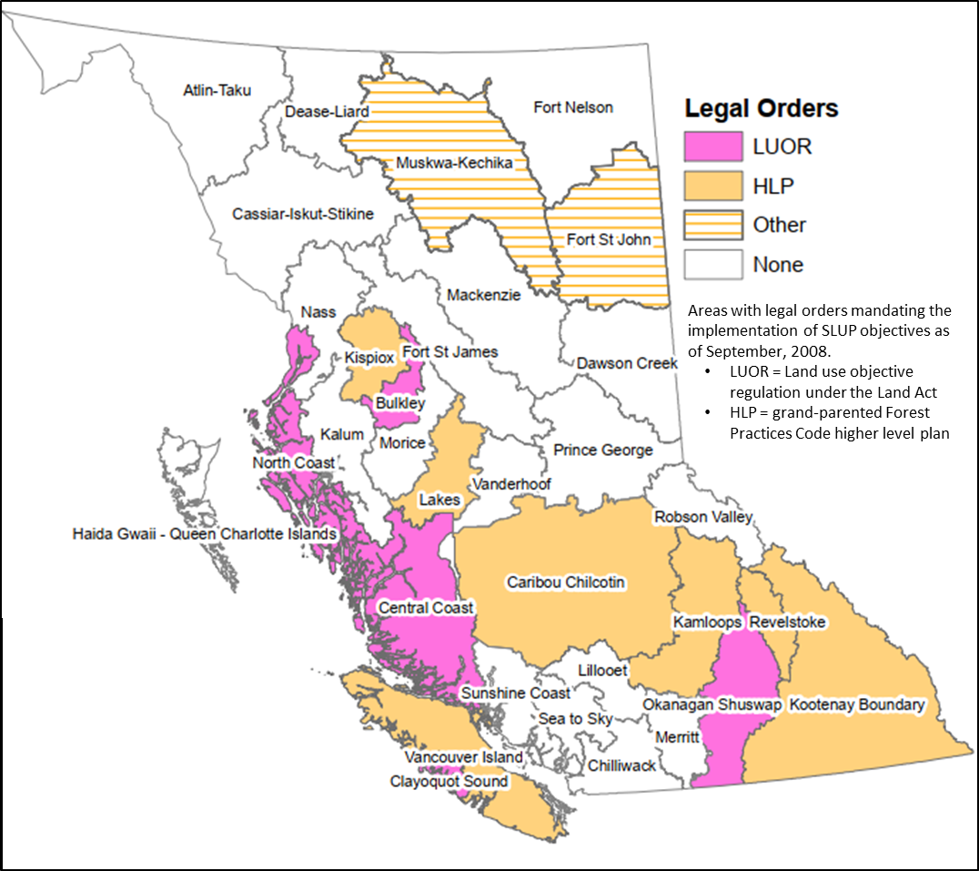
The extent to which these mechanisms have been used to implement objectives in SLUPs varies greatly and is, in part, a function of whether the related issues directly affect local residents and whether the mechanism was in place under the Code. For example, objectives for visual quality and community watersheds were well established under the Code and continue to be implemented in many places throughout the province under the FRPA regime. In contrast, objectives or measures for regionally important wildlife, or wildlife habitat features, have yet to be implemented anywhere.
The FRPA regime also contains provincial scale objectives, and practice requirements, under the Forest Planning and Practices Regulation (FPPR), the Range Planning and Practices Regulation and the Provincial Non‐Spatial Old Growth Order established under the Land Act. These objectives, and the associated practice requirements, may reflect objectives of a given SLUP. To the extent that this is the case, those SLUP objectives are legally enforceable.
Forest and range agreement holders must prepare plans (forest stewardship plans (FSPs) and range use or range stewardship plans, respectively) that specify results or strategies consistent with the objectives set by government.
In preparing FSPs, agreement holders may refer to SLUPs to clarify the “spirit and intent” of a legal objective (where an objective is vague or could be interpreted a number of ways—e.g., “maintain a mosaic of angling opportunities”), or to clarify specific terms used in a legal objectives (e.g., to more specifically define “thermal cover” and how it will be measured in the objective to “maintain at least 25 percent of the forested area in thermal cover”). Agreement holders may choose to incorporate alternative results or strategies in FSPs that reflect SLUP direction. For example, SLUP direction for pine marten could be incorporated into the results or strategies for FPPR 8 (riparian management areas) and FPPR 9.1 (stand level biodiversity), although the words “pine marten” would not appear in the FSP. If the direction is incorporated into the result or strategy for an objective, it becomes a legal commitment.
Results and/or strategies in FSPs that are tied to legal objectives are enforceable under FRPA. FSP content not tied to a legal objective is not legally enforceable.
Forest agreement holders must also prepare site plans to provide direction to operations. FRPA states that site plans must be consistent with the associated FSPs. The extent to which the SLUP direction is explicitly reflected in site plans will depend on the agreement holder’s commitment to the SLUP. SLUP direction that is out‐of‐date or unclear is unlikely to be used. Similarly, as agreement holders become less and less familiar with the SLUP, due to the passage of time and staff turnover, they are less likely to refer to it in site plans.
A key element of the FRPA regime is the reduction in regulatory burden, compared to that of the Code. FRPA’s intent was to reduce cost and administrative complexity, while maintaining high environmental standards, public acceptance of forestry operations and continued timber supply. The FRPA regime is imbedded in a policy framework that places much of the onus for maintaining these things in what some refer to as “the non‐legal realm.” Because of the relatively recent implementation of FRPA, the effectiveness of the non‐legal realm remains uncertain. While only legal constraints can require the implementation of the social choices and societal expectations expressed in SLUPs, many agreement holders and government staff have commented that social licence was indeed a factor motivating consideration of SLUPs in stewardship decisions. In the context of implementing the aspects of SLUPs related to forest and range practices, there are a number of mechanisms that affect the accountability resulting from social licence.
Professionals responsible for forest and range practices could be held accountable by their professional organizations as governed by professional accountability acts. For example, professional foresters are legally required to abide by the Code of Ethical and Professional Conduct of the Association of BC Forest Professionals (ABCFP) and could conceivably lose their right to practice if they don’t. The code of conduct states that a forester’s responsibility is to protect “the public interest by ensuring the multiple values society has assigned to BC’s forest are balanced and considered.” SLUPs provide one articulation of the values that have been assigned by society. If a forest or range professional is thought to have acted inappropriately, the principle mechanism for recourse is through a complaint to his or her professional association. However, it is forest and range agreement holders, not forest and range professionals, who are responsible for ensuring that activities on the land comply with the legal requirements of FRPA and the Land Act.
Plan implementation monitoring committees or other similar formal bodies (e.g., community resource boards) can promote accountability between the SLUP and its implementation. However, their effectiveness varies widely among SLUPs; these bodies are advisory in nature. In general, the most actively implemented SLUPs may be those that have a strong and committed public monitoring body in place.
Forestry agreement holders can enhance their social licence by obtaining certification that holds them accountable to independent standards through third‐party audits with varying degrees of rigor. Certification typically requires agreement holders to consider both the legal and non‐legal context in which they operate (which would include SLUPs) but it does not require them to implement specific SLUP provisions. Sustainable forest management plans, created for the certification process, could implement SLUP direction. Agreement holders are not legally accountable for commitments made in a sustainable forest management plan. We also note that SLUPs can be used to guide the preparation and approval of forest stewardship plans (FSPs) in a number of non‐legally binding ways. For example, district policy based on SLUPs can be interpreted as standard practices, and those could be cited in FSPs. Standard practices are assumed to represent a lower risks to the resource value, and require less supporting documentation than innovative practices.
LRMPs often led to the creation of Access Management Plans. As per its name, the general purpose of these plans is to help manage access to Crown land in the midst of multiple and often conflicting uses, such as resource development and back-country recreation. To manage access, each plan considers social, environmental, and economic values.
For example, the Vanderhoof Access Management Plan aims to ensure industrial and public access while also addressing the affects of providing access for such uses. Key elements of the plan include the following:
A Crown Land Plan is a sub-regional plan based on within settlement corridors. The purpose of a Crown Land Plan is to establish policy to guide the planning, management, and disposition of vacant Crown lands regarding residential, recreational, commercial, industrial, and institutional uses. Since the 1980s, only a few Crown Land Pans were created, perhaps only six. These include plans for each of the areas surrounding Fort St. James, Vanderhoof, and Prince George. A Crown Land Plan is primarily a map showing land designations accompanied by a legend and definitions of designations. Although Crown Land Plans exist, they are not referenced frequently.
The Fort St. James Crown Land Plan helps to illustrate the purpose and scope of these plans. Land use designations were based on “highest and best use” with consideration for the productive capability of the land (e.g., for agricultural use) and for the suitability of the land for specific uses. The capability of land accounted for such biophysical factors as climate, slope, landform, soils, and geology. The suitability of land considered present use, proximity, local agreements, and land use conflicts. The process to complete the plan was directed by a steering committee and informed by public consultations.
Crown Land Plans are connected with LRMPs in two ways. Crown Land Plans that existed prior to the creation of LRMPs were used to guide the development of the LRMP. In other cases, some LRMPs included an action item to create a Crown Land Plan.
In 2006, the Province of British Columbia shifted priorities for regional land use planning. This effort was branded as a “new direction” for Strategic Land Use Planning, as follows. The government’s priority to establish a “new relationship” with Indigenous peoples was a major thrust for this policy change. The text below is from the provincial document that set forth this new direction (pp. 8-13):
The following key questions have been addressed and a ‘New Direction’ for strategic land use planning formulated in response:
Direction
1.1 Establish a strategic plan implementation monitoring committee (PIMC) for geographical regions or sub-regions of the Province, representing all the LRMPs and SRMPs completed in the geographical area. Include representation from key participants in the LRMP and SRMP processes, as well as Indigenous Nations. Develop a standard terms of reference for the PIMCs, clearly outlining their role and responsibilities, membership, and level of support.
1.2 Develop an action plan to migrate existing monitoring and implementation committees into these structures by March 31, 2007.
1.3 Restrict LRMPs and SRMP updating or amendment activities to specific components of a plan, as opposed to the entire plan. Require approval of updating or amendment requests by the inter-agency management committees (IAMCs). Develop standard procedures for Indigenous Nations engagement, and for consultation with the public and interested parties not represented on the PIMC.
1.4 Establish a list of priority circumstances that may warrant plan component updating or amendment. This list should include the need to align plan recommendations with policy and legislative changes, to reflect critical new information such as Indigenous Nations’ interests and values, and major environmental changes such as Mountain Pine Beetle infestation.
1.5 If a business case can be made for a comprehensive and thorough update of an LRMP to reflect new legislation, policy, information or environmental changes this should be done through the development of a specific plan or planning study for the topic or issue in question and forwarded to the ILMB Board of Directors for approval.
1.6 Support the updating or amendment of existing approved LRMPs and/or SRMPs affected by the Mountain Pine Beetle epidemic.
2. Legacy LRMPs: How do we expedite government decisions for the remaining LRMPs and complete the follow-up work required?
Direction
2.1 Conclude G2G discussions on all remaining legacy LRMPs (Morice, Sea to Sky, Lillooet and HG/QCI) by March 31, 2007 for Cabinet decisions and land use announcements.
2.2 Set a three year maximum time limit (end of fiscal 2009/2010) for completion of any follow-up work required for government decisions made for the Lillooet, Morice, HG/QCI, and Sea to Sky LRMPs, should completion work be necessary.
2.3 Require any further LRMP completion requirements (e.g., EBM, adaptive management, conservancy management, Indigenous Nations interim measures, community support) to become the responsibility of the relevant ministry after the end of fiscal 2009/10, following which ILMB will restrict its level of support to planning and implementation monitoring functions.
2.4 Legacy LRMP plan implementation monitoring structures will be integrated into the sub-regional implementation structure recommended in Part 1 above.
3. FRPA planning requirements: How do we honour our current commitments to complete legislated FRPA planning while addressing new planning pressures?
Direction
3.1 Undertake an assessment of the extent of planning required for the successful implementation of the current FRPA planning model. Develop an action plan that includes a schedule and list of priorities that will allow the completion of SRMPs for OGMA objectives in support of FRPA purposes by December 31, 2007.
3.2 Complete biodiversity planning by the end of fiscal 2007/08.
3.3 Continue the FRPA planning that relates to establishing legal objectives.
3.4 Wherever possible, create efficiencies by building planning for FRPA values into plans done in partnership with Indigenous Nations, the forest sector and other stakeholders.
3.5 Complete the development of legal objectives for EBM for application on the Central and North Coast and HG/QCI.
4. New strategic plans: Should we do new strategic plans and if so, what are the circumstances, priorities, processes and products?
Direction
4.1 Confirm the conclusion of the LRMP program and the initiation of new planning direction when announcing government land use decisions for the remaining legacy LRMPs.
4.2 Drop the LRMP and SRMP terminology and re-brand the strategic planning program (e.g., Strategic Land and Resource Plans).
4.3 Review strategic planning guidelines and procedure to ensure a focus on product requirements (e.g. FRPA, marine, land allocation) as opposed to hierarchical, geographical area-based plan requirements.
4.4 Initiate new strategic planning according to the following list of priorities and only in circumstances where:
4.5 Require a “plan scoping” exercise be undertaken before formally proposing the initiation and funding of a new strategic plan.
4.6 Require ILMB Board of Directors’ endorsement prior to initiation of any new strategic plan, and based on recommendations of the “plan scoping” exercise.
4.7 All new strategic planning processes should adhere to the following principles:
4.8 Product or outcomes of strategic plans should be:
4.9 New strategic planning design, process and techniques should be structured on recommendations of the risk assessment for strategic planning.
4.10 New plans should be undertaken only when the beneficiary or implementing agencies are prepared to support the costs of implementation.
5. Indigenous Nations: What framework and processes do we use to address the New Relationship commitments to strategic land use planning with Indigenous Nations?
Direction
5.1 Develop a strategic planning Statement of Intent with the First Nations Leadership Council that provides overarching direction in accordance with key principles based on an assessment of existing, more detailed planning protocols.
5.2 Develop planning protocols with individual Indigenous Nations, where appropriate, based on the principles in the Statement of Intent developed with the Leadership Council.
5.3 Ensure that planning processes are jointly developed, address capacity, decision-making and conflict resolution, and are mutually acceptable. Strive to reach formal agreement with individual Indigenous Nations or where possible, aggregations of Indigenous Nations at the plan level on both planning processes and products, recognizing that agreements differ in each case.
5.4 Focus Indigenous Nations’ involvement in new planning and plan updating or amendment processes on incorporation of Indigenous Nations’ values and interests, and on land and resource management issues and outcomes that provide direction for these values and interests.
5.5 Ensure plan updating activities generated by PIMCs are done in collaboration with Indigenous Nations, where Indigenous Nations have responded positively to requests for engagement. Plan updating will be led by government in collaboration with Indigenous Nations and with advice from the appropriate implementation and monitoring committee.
5.6 Establish priorities for updating and amending existing plans based on:
5.7 Pursue planning process outcomes with Indigenous Nations that will reduce and streamline subsequent consultation requirements for specific developments. Planning outcomes must improve resource management and development certainty for investors, the province and Indigenous Nations.
5.8 Support for Indigenous Nations’ requests for planning funds should be guided by the following:
5.9 Continue with FRPA planning, but provide for broader engagement on strategic issues with affected Indigenous Nations to support forest and range operations on public lands. On an interim basis, until Indigenous Nations’ values and interests are incorporated into existing plans, use FRPA and Land Act provisions to manage environmental values considered important to Indigenous Nations. Amend and revise legal resource management objectives after Indigenous Nations’ values and interests are incorporated into these plans.
5.10 Consider a regionally-based process, similar to the regime now in place for the Coast, such as a traditional territory or grouped Indigenous Nation territories, where the province works collaboratively with Indigenous Nations to confirm broad areas expressing level of opportunity versus constraint, or confirm areas with different value levels that warrant variable management regimes relative to resource development activity. For each of the above areas, a different level of Indigenous Nations’ involvement in subsequent activity can be negotiated, ranging from conservancy management agreements to refined and coordinated referral processes.
5.11 Ensure planning processes and G2G planning tables do not become surrogate forums for negotiation of rights and title, interim measures and other treaty-related issues, and for negotiation over individual land transaction issues.
6. Funding and staffing: How do we allocate resources to meet the new planning direction and the associated government priorities?
Direction
6.1 Establish a three year maximum time limit for the end of ILMB’s responsibility to fund completion work by other agencies and by Indigenous Nations (e.g. protected areas, conservancy management and planning) associated with Cabinet land use plan decisions. After this period, funding for agency completion work should be advanced by the appropriate agency as part of its own budget submission.
6.2 Ensure that plan mandate and plan decision documents clearly identify the anticipated fiscal implications of proposed negotiating mandates and final land use plan recommendations to Cabinet on agency operational costs.
6.3 Ensure agencies are made aware of the need to incorporate anticipated additional operational costs resulting from Cabinet land use decisions into their individual budget submissions to Treasury Board, particularly those costs that will be assumed from ILMB after the three year maximum time limit for ILMB funding of legacy plan completion work as noted in 6.1 above.
6.4 Establish a budget contingency to address unforeseen planning demands and unforeseen planning projects with Indigenous Nations.
6.5 Continue ILMB’s FRPA related planning and development of associated legal objectives only the basis of availability of FIA and CLUPE funding.
6.6 Maintain ILMB capability to represent the province in federal and local government planning processes where provincial interests and programs may be at risk, including maintenance of a marine and coastal planning program to support provincial involvement in federal oceans planning program, a marine protected areas initiative, and foreshore and marine resource allocation programs.
6.7 Assign resources to amend existing approved strategic plans affected by the Mountain Pine Beetle epidemic.
6.8 Provide sufficient resources for ongoing monitoring and amendment of OGMA/biodiversity plans.
6.9 Continue ILMB funding of implementation monitoring committees formed to provide oversight to ongoing plan implementation activities, as well as funding of new plans and plan revisions. Provide for a uniform level of funding for the operation of the new PIMCs and dedicate regional staff support to administer the PIMCs.
6.10 Provide sufficient resources to administer legal objectives and support ILMB/MAL’s role in FRPA implementation – in ILMB regions and in Crown Land Administration Division of MAL, and ILMB, Victoria.
6.11 Support the re-establishment of strategic planning staff in resource agencies to provide capacity for direct participation in strategic plan development, and in implementation of land use plans and decisions.
Currently, the Province of BC is pursuing a policy direction to “modernise” regional land use planning. The drivers for this shift in policy centres are as follows:
The current direction for regional land use planning is presented on the government’s website, as presented below.
Source: Modernizing Land Use Planning.
The B.C. government is committed to collaborating with Indigenous governments in natural resource management that is informed by the United Nations Declaration on the Rights of Indigenous Peoples (UNDRIP) and the Truth and Reconciliation Commission Calls to Action. As part of this approach, it has committed $16 million over three years (2018-19 to 2020-21) to work collaboratively with Indigenous governments, communities, and stakeholders to modernize land use planning.
Land use planning sets the strategic direction to guide sustainable resource stewardship and management of provincial public land and waters that meets economic, environmental, social, and cultural objectives. In other words, it sets high-level direction and helps define ‘what’ can occur on the land base. Modernized land use planning is led by the B.C. government in partnership with Indigenous governments and with engagement of communities, local government, industry and other stakeholders. Land use planning will focus on priority areas in the province to resolve current land use and resource management challenges.
Ninety-four percent of British Columbia is provincial public land. Existing land use plans in B.C. cover over 90% of provincial public land. However, today’s land and resource management challenges require a renewed approach to land use planning. Key drivers include:
Modernizing land use planning will support past planning and ongoing stewardship initiatives, and capitalize on new opportunities in response to emerging challenges in the management of B.C.’s public lands and natural resources.
As well as advancing reconciliation efforts, land use planning will support economic opportunities, increase certainty for those who operate on the land and provide trusted stewardship of B.C.’s natural resources.
Land use planning will be carried out in partnership between the B.C. government and Indigenous governments. The values, traditions, knowledge, and cultural practices of Indigenous people will be an integral component of planning processes.
Land use planning will improve dialogue between the B.C. government, Indigenous governments, and industry. It will help build relationships and identify solutions needed to advance economic opportunities for rural communities and create lasting economic benefits for all B.C. residents.
Land use planning will help manage our resources in a changing climate. Updated data and information from ongoing stewardship initiatives will support and inform planning processes.
The Ministry of Forests, Lands, Natural Resource Operations and Rural Development and the Ministry of Indigenous Relations and Reconciliation are partnering with Indigenous governments and engaging with stakeholders to design and develop the modernized approach.
Targeted engagement with local governments, industry, non-government organizations, stakeholders, and the public throughout all planning processes will ensure various interests are identified and considered in all plans.
Land use planning will be targeted to selected priority areas throughout the province on provincial public land and waters. It will not include federal lands and water, private lands, or provincially designated Agricultural Land Reserve lands.
The B.C. government has been engaging with Indigenous governments and stakeholders to identify high-priority planning projects. Projects will focus on urgent land-based management challenges and will support provincial priorities, including reconciliation and the economy. New land use planning projects will begin in 2019-2020.
42
LEARNING MODULE
A number of financial and regulatory tools exist that local governments can use to support downtown revitalisation and influence the type and location of urban growth. The general aim of each tool is to provide some kind of financial incentive for developers to invest in capital projects, which might be either new construction of residential or commercial buildings or capital improvements. The benefits of these programs can include attracting new businesses, directing growth in specific locations, or improving the aesthetics of a downtown area, among other things. In addition to the range of tools available, there exist a range of considerations to be made regarding how each tool is implemented. These considerations include types of developments, amount and length of exemption, and geographic area, among other factors.
As part of a rezoning process initiated by a developer, community amenity contributions (CACs) are negotiated between the developer and local government. As the name infers, these contributions support public amenities, such as affordable housing, libraries, and fire halls, as well as financial contributions towards amenities. The contribution is provided by the developer to the local government. CACs are voluntary because, unlike DCCs, they are not enabled through provincial legislation; CACs are created by a local government’s discretionary power for zoning.
A combination of regulatory and financial tools are used as part of a broader strategies for downtown revitalisation, growth management, and economic development. Regulatory and financial tools can be designed and applied in conjunction with statutory plans, zoning by-laws, and building codes to achieve different land use strategies, such as the following.
This growth management strategy combines two priority patterns of land use:
Nodes: focussed, higher-density, and mixed-use centres, such as downtown areas, transit hubs, high-density housing, and high-use destinations.
Corridors: linear connections among nodes based on transportation routes that support concentrated, and predominantly retail, development; can employ primary and secondary corridors.
As the name implies, one land use strategy is to focus development in close proximity to a transit node (e.g., train or light rail station, high-use bus stop). The form of development is dense within walking distance of the transit node. Types of development can include commercial, office, residential, retail, and entertainment. This combination of transit node and form and type of development promotes a symbiotic relationship among mixed uses that reduces reliance on private transport while increasing ridership of public transit.
Clustering residential development is a land use strategy used in rural areas. Two primary aims are complementary. One aim is to minimise the overall footprint of a residential development in order to reduce alienation of agricultural land. A second aim is to deliver residential services more efficiently by also clustering the infrastructure required for residential uses, such as energy and communications.
43
LEARNING MODULE
The materials in this module are adapted from the following policy brief:
Connell, David J. (2018). Farmland Protection: Strengthening BC’s Legislation. Prince George, BC: University of Northern British Columbia.
The most common way to evaluate how well agricultural land is being protected is to measure the amount of farmland is converted to other uses, usually to residential, commercial, or industrial uses. Unfortunately, the record across Canada is poor. All urbanised areas have experienced significant losses of its agricultural land base, especially the loss of some of Canada’s best quality farmland.
In British Columbia (BC), the total area of land within the Agricultural Land Reserve (ALR) has remained fairly constant since 1974, with about 4.6 million hectares province-wide (Box 1). However, this overall statistic hides the fact that there have been changes in the types of agricultural land within the ALR. Between 1974 and 2008, the province has lost some of its highest quality agricultural land, mostly to urban development in the Lower Mainland. These losses have been offset by additions of lower capability agricultural land in other parts of the province. Consequently, “the quality of farmland in the ALR has decreased, with 2.8 hectares of prime farmland being excluded for every hectare of prime farmland included.”
Sources: Smith (1998); ALC (n.d.)
In addition to measuring changes in the agricultural land base, it is also important to know about the quality of the policy used to protect this land base. Protecting agricultural land is primarily a concern of land use planning. Altogether, and across jurisdictions, a legislative framework for agricultural land use planning includes laws, policies, regulations, codes of practice, guidelines, bylaws, strategies, plans, and governance structures. Many forms of government statements, at all levels of government, make up a legislative framework. A local legislative framework includes a statutory plan as well as the related regulations, policies, and strategies that frame the plan, and extend both vertically to other levels of government and horizontally to neighboring jurisdictions. A legislative framework to protect agricultural land defines the context and constraints for what a government can and must do.
It is possible to measure the quality of a legislative framework by measuring its strength of policy focus. Within the field of plan evaluation, this method is concerned with efficacy, which is the power to produce effects (rather a measure of the effects or outcomes themselves). The aim is to evaluate the content of all the elements that make up the legislative framework.
Across North America, BC is regarded widely as one of the most progressive legislative frameworks for protecting its agricultural land base. Among all provinces in Canada, the Province of BC ranks among the strongest, second only to Québec. In this module, we look at the strength of farmland protection policy for regional districts across the province and for both levels of local government in the Lower Mainland.
To measure the strength of legislative frameworks, the method of evaluation centres on a set of four principles:
These four principles are described in more detail in Appendix A.
Across the province, the strength of local legislative frameworks for farmland protection vary from very strong to somewhat weak. Although local governments are required to have statutory plans and zoning bylaws that are consistent with the ALC Act to preserve agricultural land, the results of recent analyses demonstrate a high level of inconsistency. The results for assessed regional districts are shown in Figure 1.
Figure 1. Map showing strength of legislative frameworks to protect farmland for assessed regional districts
A closer look at the strength of legislative frameworks in the Lower Mainland are not consistent between the two regional districts and their member municipalities. This area of the province has very productive agricultural lands but must also contend with very high pressure from urban development. The results in Table 1 (and Figure 2) show that the strength of the legislative frameworks for the two regional districts are different, as are the strengths of frameworks among its member municipalities. These inconsistencies highlight the need for a greater level of required integration across jurisdictions.
Table 1. Strength of legislative framework: Metro Vancouver and Fraser Valley Regional Districts
Figure 2. Strengths of municipal legislative frameworks: Lower Mainland
Maximise stability A stable legislative framework is one that makes a clear, legally-enforceable commitment to protect agricultural land. This commitment should be firmly established in statutory plans and steady in purpose. For example, “to protect agricultural land” is a strong, clear, and direct statement; “support agricultural uses of agricultural land” is moderate; and “support agriculture” is helpful, but weaker. The location in the document of the most important statements also contributes to stability. Generally, statements at the front end of a plan are important for expressing broader, over-arching public priorities, including a long-term vision and goals for land use planning. Where agriculture is a dominant feature of the landscape and economy, it is important to acknowledge the role of agriculture at the outset. Issues and driving concerns (e.g., loss of farmland and urban development pressures) should also be included. To maximise stability, the statutory plan warrants a policy section dedicated to agricultural land that includes goals and objectives to protect farmland and support agriculture. In a high quality legislative framework, a statutory plan is supported by zoning and other implementing bylaws. Jurisdictions with areas that include a significant portion of contiguous agricultural land should consider adopting a sub-area plan (i.e., agricultural area plan), which can provide more detailed goals, objectives, and policies for a geographically-limited agricultural area. In addition, a clear commitment expressed in the statutory plan should be substantiated by enforceable policies, such as an agricultural strategy, agricultural land use inventory, and food security strategy, all of which would include additional details such as a sector profile, statistics, maps, and action plans. |
Integrate public priorities across jurisdictions Integrating public priorities across jurisdictions is about one government formally aligning its commitment to protect agricultural land with similar priorities of other levels of government. For example, a local government should include a dedicated section within its statutory plan (and other relevant documents) that explicitly explains how its commitment to protect agricultural land aligns with provincial interests to protect agricultural land. Three factors influence how a commitment to protect agricultural land can be aligned with broader public priorities. First, senior governments often require lower-level government bylaws “to be consistent with” or “to conform to” upper-level legislative frameworks. Second, a local government’s authority over land use planning is affected by the extent to which senior levels of government retain (or delegate) approval of local government statutory plans and implementing bylaws. Third, if there is room for discretion, a local government may express its interest in protecting agricultural land in a way that exceeds minimum requirements. For a local government, an expression of integration can range from a single sentence that demonstrates consistency in general terms (weak) to a detailed statement that demonstrates consistency with agricultural land use policies (strong). However, if an upper-level government has a weak legislative framework, there is limited benefit for a local government to integrate. The principle of integration also applies horizontally with other municipal or regional governments at the same level, as well as with agencies working with the government. Continued on next page |
Minimise uncertainty A local government’s commitment to protect agricultural land should not be compromised by its other priorities or land use policies, especially policies related to urban development. Threats of non-farm development can be minimised through urban growth management policies that include designated urban growth boundaries and density targets. This commitment must be clear, direct, and integrated with other policies to help direct future development to urban areas. A review of the urban growth boundary should include a timeline for review, a mechanism to change the boundary, and target thresholds (e.g., based on population projections, estimates of land supply/capacity, and combinations thereof) that will trigger changes when conditions are met. Explicitly linking urban growth management to protecting agricultural land reinforces the mutual benefits of the two policies. Ambiguous language and open-ended conditions can contribute to uncertainty by undermining a commitment to protect agricultural land. Ambiguous language appears in different forms. Qualifying terms are those included at the end of a sentence, usually preceded by a comma. For example, a government may state its goal as “To protect farmland, whenever feasible.” These types of qualifiers raise questions regarding intent, signifying loopholes that can support the conversion and alienation of farmland. Similarly, the use of an unspecified qualifier for agricultural lands, e.g., “to protect viable agricultural land,” introduces uncertainty. Beneficial practices include policy tools, such as covenants and designating specific areas for future development under pre-defined conditions, and clear restrictions regarding non-farm activities in agricultural areas. Recognising “right to farm” legislation is also very important. |
Accommodate flexibility The principle of accommodating flexibility is concerned with how known or new needs and interests are addressed alongside a commitment to protect agricultural land. Thus, this principle recognises that policies that accommodate non-farm development may be justified when a need for alternative uses is substantiated. Importantly, a government should consider how it might accommodate flexibility within its legislative framework only after it addresses the other three principles. An important means to accommodate flexibility is through governance mechanisms, such as agricultural advisory committees. Governance mechanisms, in conjunction with associated tools (e.g., agricultural impact assessments), ensure that agricultural voices and interests are represented in the decision-making process. Agricultural impact assessments should be required when considering non-farm developments that affect agricultural land and farming activities. Several other beneficial practices can be employed to accommodate flexibility. Edge planning addresses farm/non-farm interface areas that are vulnerable to conflicts by using planning techniques (e.g., buffers and setbacks). The BC Ministry of Agriculture has produced a comprehensive guide to edge planning. Development permit areas help to accommodate flexibility by designating geographic locations that need special treatment for certain purposes, such as edge planning. Source: Connell, David J. (2020). “Protecting Farmland: Principles and Beneficial Practices.” Plan Canada, 60(1): 8-12. [On-line by paid subscription]
|
44
LEARNING MODULE
The materials in this module are adapted from the following source:
Connell, David J. (2021). “The Quality of Farmland Protection in Canada: An Evaluation of the Strength of Provincial Legislative Frameworks.” Canadian Planning and Policy/Aménagement et politique au Canada. Volume 2021, pp. 109-30.
Although Canada is among the top countries exporting agricultural products, the national agricultural land base is both limited and diverse. First, only about 7% of the land base is used for agriculture (Hoffman, Filoso, & Schofield, 2005; Statistics Canada, 2014). Second, agricultural land is not distributed equally across all regions of Canada, with vast differences among provinces. Saskatchewan has about 40% of the national agricultural land base; Newfoundland and Labrador (NL) has only 0.05 percent. Furthermore, we must consider not only the quantity of agricultural land but also its quality, as measured by agricultural capability (Appendix A). As shown in Figure 1 and Table 1, Saskatchewan also has the greatest amount of the most capable agricultural land (Canada Land Inventory Classes 1, 2, and 3), followed by Alberta, Ontario, and Manitoba. We can also see extremes when we look at agricultural land as a percentage of a provincial land base. Over 70% of Prince Edward Island’s land base is agricultural; only 0.7% of British Columbia’s land base is agricultural.
Since the 1950s, many studies have documented the continual loss of agricultural land and raised concerns about the future. The maps shown in Figures 2 and 3 illustrate that the loss of agricultural land between 1961 and 1976 is strongly associated with urban areas across Canada (also see Box 1).
Figure 1. Extent of the Agricultural Land Base in Canada.
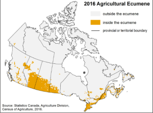
Table 1. Amount of Dependable Agricultural Land (km2), Canada and Provinces
The information in this table is adapted from two Rural and Small Town Analysis Bulletins published by Statistics Canada in 2001 and 2005.
Prime Agricultural Land | |||||||
Province/Territory | Class 1 | Class 2 | Class 3 | Prime Agricultural Land | Total Land Area of Province | …as Percent of Total Land within each Province | …as Percent of Canada’s Total Agricultural Land |
Newfoundland Labrador | – | – | 67 | 67 | 405,720 | 0.0 | 0.0 |
Prince Edward Island | – | 2,626 | 1,422 | 4,048 | 5,660 | 71.5 | 0.8 |
Nova Scotia | – | 1,700 | 10,219 | 11,919 | 55,490 | 21.5 | 2.4 |
New Brunswick | – | 2,056 | 13,823 | 15,879 | 73,440 | 21.6 | 3.2 |
Quebec | 223 | 10,713 | 13,625 | 24,561 | 1,540,680 | 1.6 | 5.0 |
Ontario | 27,635 | 23,335 | 25,567 | 76,537 | 1,068,580 | 7.2 | 15.5 |
Manitoba | 2,111 | 29,617 | 24,499 | 56,227 | 649,950 | 8.7 | 11.4 |
Saskatchewan | 12,282 | 73,341 | 104,482 | 190,105 | 652,330 | 29.1 | 38.6 |
Alberta | 6,719 | 38,701 | 61,039 | 106,459 | 661,190 | 16.1 | 21.6 |
British Columbia | 78 | 1,574 | 5,270 | 6,922 | 947,800 | 0.7 | 1.4 |
Yukon | – | – | – | – | 483,450 | 0.0 | 0.0 |
Northwest Territories | – | – | – | – | 3,426,320 | 0.0 | 0.0 |
Canada | 49,048 | 183,663 | 260,013 | 492,724 | 9,997,610 | 4.9 | 100.0 |
Figure 2. Total farmland losses and gains in western Canada (1961-1976))
Source: McCuaig and Manning (1982).
Figure 3. Total farmland losses and gains in eastern Canada (1961-1976))
Source: McCuaig and Manning (1982).
The combination of unequal amounts of agricultural land among provinces and varying degrees of urban pressure on the agricultural land base means that each province faces different circumstances regarding both the significance of agricultural land and the need to protect it. Correspondingly, provincial policy to protect agricultural land also varies, reflecting a mix of interests and efforts by all levels of government.
The most common way to evaluate how well agricultural land is being protected is to measure the amount of farmland is converted to other uses, usually to residential, commercial, or industrial uses. Unfortunately, the record across Canada is poor. All urbanised areas have experienced significant losses of its agricultural land base, especially the loss of some of Canada’s best quality farmland.
In addition to measuring changes in the agricultural land base, it is also important to know about the quality of the policy used to protect this land base. Protecting agricultural land is primarily a concern of land use planning. Altogether, and across jurisdictions, a legislative framework for agricultural land use planning includes laws, policies, regulations, codes of practice, guidelines, bylaws, strategies, plans, and governance structures. Many forms of government statements, at all levels of government, make up a legislative framework. A local legislative framework includes a statutory plan as well as the related regulations, policies, and strategies that frame the plan, and extend both vertically to other levels of government and horizontally to neighbouring jurisdictions. A legislative framework to protect agricultural land defines the context and constraints for what a government can and must do.
It is possible to measure the quality of a legislative framework by measuring its strength of policy focus. Within the field of plan evaluation, this method is concerned with efficacy, which is the power to produce effects (rather a measure of the effects or outcomes themselves). The aim is to evaluate the content of all the elements that make up the legislative framework. In this module, we look at the strength of farmland protection policy for all provinces in Canada.
To measure the strength of legislative frameworks, the method of evaluation centres on a set of four principles. Each is described briefly here, and in more detail in Appendix B.
The above four principles are used as criteria to evaluate the strength of legislative frameworks. The method involves analysing the content of all relevant laws, regulations, and policies that make up each provincial legislative framework for protecting agricultural land. The scoring is based on the presence and strength of specified items (see Appendix C). Each principle is scored on a scale from very weak (1) to very strong (5), based on the results of the content analysis.
The method can be applied not only to provinces but also to regions within a province. In Canada, there are substantial differences within the provincial legislative frameworks of BC and Ontario that warrant special attention. In BC, one zone is covered by the ALC Act; the other zone is the northeast region of the province, which includes a substantial portion (about 31%) of the province’s agricultural lands. This northeast region has very high levels of oil and gas activities, which are governed by the Oil and Gas Commission (OGC). The ALC has a delegation agreement with the OGC, such that the OGC is responsible for carrying out the mandate of the ALC—while also being responsible for oil and gas development in agricultural areas. The delegation agreement views oil and gas developments as temporary uses of agricultural land and includes conditions for mitigating impacts of permitted activities. We denote these two zones as BC.ALC and BC.OGC. In Ontario, all agricultural land in the province is covered by the Provincial Policy Statement (PPS), with higher priorities for prime agricultural land and specialty crop areas. In the Greater Golden Horseshoe area, which surrounds and includes the metropolitan area of the City of Toronto, a package of additional legislation applies, including the Greenbelt Act, Niagara Escarpment Planning and Development Act, and Places to Grow Act. We treat this “Greenbelt” area with an enhanced legislative framework as separate from the rest of the province. The effect of this additional legislation is to create two agricultural areas, one area of agricultural land covered by only the PPS (denoted as ON.PPS) and the agricultural land within the Greenbelt (denoted at ON.GB). Thus, to measure the strength of policy to protect agricultural land, each province of BC and Ontario is treated as having two legislative frameworks.
Across Canada, results show that provincial legislative frameworks to protect agricultural land range from strong to weak (Table 2). Québec has the strongest policy focus followed by BC (ALC) and Ontario (GB). The provinces of Nova Scotia, New Brunswick, Manitoba, and Saskatchewan have somewhat weak legislative frameworks. PEI, NL, and Alberta have weak frameworks (with the caveat that PEI recently amended its legislative framework and may yet adopt farmland protection policy). The diversity of all the results indicate that no two provinces have the same scores for all four principles.
Table 2. Provincial Legislative Frameworks: Assessment of Strength
Province | Overall strength | Stability | Integration | Uncertainty | Flexibility | |
QC | Strong | 5 | 4 | 4 | 3 | |
BC.ALC | Somewhat Strong | 5 | 3 | 4 | 4 | |
ON.GB | Somewhat Strong | 4 | 4 | 3 | 4 | |
ON.PPS | Moderate | 3 | 4 | 3 | 4 | |
BC.OGC | Moderate | 4 | 2 | 3 | 4 | |
NS | Somewhat Weak | 3 | 3 | 3 | 3 | |
NB | Somewhat Weak | 3 | 4 | 1 | 2 | |
MB | Somewhat Weak | 3 | 3 | 2 | 2 | |
SK | Somewhat Weak | 2 | 4 | 3 | 2 | |
PE | Weak | 2 | 4 | 2 | 2 | |
NL | Weak | 2 | 3 | 2 | 3 | |
AB | Weak | 2 | 3 | 2 | 1 | |
For the following, we describe the most important aspects of each provincial legislative framework, in order from strongest to weakest.
The policy focus of Québec’s legislative framework is strong overall, and the strongest among all provinces in Canada. Regarding stability, the most important element of Québec’s legislative framework is the Loi sur la protection du territoire et des activités agricoles (LPTAA), which was enacted in 1978. The purpose of the LPTAA (c. P-41.1 c. 1 1.1) is to “secure a lasting territorial basis for the practice of agriculture, and to promote, in keeping with the concept of sustainable development, the preservation and development of agricultural activities and enterprises in the agricultural zones established by the regime.” For this purpose, the LPTAA establishes a province-wide agricultural land reserve, a land use zone within which agriculture is a priority use, farming and ranching are encouraged, and non-farm uses are restricted. The LPTAA has priority over all other general or special laws.
Strong requirements for integrating public priorities for protecting agricultural lands in local land use plans are included in both the LPTAA (c. 3 s. 79.1) and Loi sur l’aménagement et l’urbanisme (LAU c. 1. s. 5). Both acts require local governments to promote agricultural purposes as the priority use of agricultural land. The LAU, which governs land use planning by local governments, includes the Orientations gouvernementales (or Guidelines). Land use plans of municipalities, metropolitan areas, and regional county municipalities (MRCs) must be consistent with the Guidelines.
The primary governance mechanism to accommodate flexibility is the Commission de protection du territoire agricole du Québec (CPTAQ), an autonomous, quasi-judicial body whose only function is to protect agricultural land. Central to the land management process are applications to CPTAQ, which cover including or excluding land from the agricultural land reserve, subdivision, and non-farm uses. A local government must fully substantiate an application to CPTAQ (LPTAA c.2 s.26). When rendering a decision (LPTAA c. 2 s. 62), CPTAQ must take a range of factors into consideration, including local conditions.
British Columbia and Québec are very similar, although BC has a lower rating of overall strength at somewhat strong. The primary element of the legislative framework is the Agricultural Land Commission Act (ALC Act), enacted in 1973 to establish the Agricultural Land Reserve (ALR) and the quasi-judicial Agricultural Land Commission (ALC). The ALC Act uses restrictive land zoning to protect agricultural land, plays a critical role in land use policies, and takes precedence over other legislation, including land use bylaws of local governments. The ALC Act and ALR contribute to a very strong level of stability. Strong language in the ALC Act and the Local Government Act (LGA) supports a strong level of integration between provincial interests in protecting farmland and local governments. However, the provincial government does not approve statutory plans. Instead, the LGA requires local governments only to consult with the ALC (s. 475(4)) and refer to the ALC for comment (s. 477(3)(b)), which undermine the strength of integration. Like the CPTAQ, the ALC is a quasi-judicial tribunal with a mandate (s. 6) to protect the ALR.
The policy focus of Ontario’s legislative framework for the Greenbelt area (ON.GB) is somewhat strong overall. The strong stability of the legislative framework resides in the Planning Act, which sets goals for protecting farmland. The Provincial Policy Statement (PPS), which is an enforceable policy subject to review every five years, provides direction to local planning authorities for matters of provincial interest. All agricultural land in the province is covered by the PPS, with higher priorities for prime agricultural land and specialty crop areas. Integration across jurisdictions is strong. Decisions of local planning authorities “shall be consistent with” the PPS and “shall conform with” provincial plans (Planning Act s. 3(5)). The identification of agricultural lands contributes to uncertainty. Local governments have the option to define “prime” agricultural lands, most often using a method that combines CLI ratings with ratings of suitability (e.g., parcel size, nearby conflicting land uses). The standard method is Land Evaluation and Area Rating (LEAR).
The overall strength of New Brunswick’s framework is somewhat weak. The most important source of strength is the Agricultural Land Policy (ALP), adopted in 2017 “to provide a framework to guide government decision making relative to the protection and development of agricultural lands in the Province of New Brunswick” (p. 3). The ALP is an enforceable policy. The Agricultural Land Protection and Development Act (ALPDA) (s. 4(a)) establishes agricultural land owner associations, which have the legislated purpose “to promote and facilitate the stewardship, protection and improvement of agricultural land.” A strength of the framework is strong integration of priorities across jurisdictions, primarily through ministerial approval of statutory plans. Importantly, the ALP states that land use planning in the province “shall reflect the importance of agriculture” (p. 6). The Community Planning Act (CPA) states that local government plans shall be consistent with provincial policy. However, the CPA has no specific references to the protection of agricultural land.
The policy focus of Manitoba’s legislative framework is somewhat weak overall, with a moderate rating for stability. A provincial interest in protecting agricultural land is part of the Provincial Land Use Policies (PLUP), under the Provincial Planning Regulation (R.M. 81/2011). The PLUP (Policy Area 3) states, “Planning for the agricultural use of these lands and protecting them from conversion to non-farm use is vital to the future of Manitoba’s agricultural sector.” The legislative framework has a moderate level of integration. As required in The Planning Act (s.41), all local statutory land use plans must be submitted to the minister for approval. However, whereas most provinces use the term, “must be consistent with,” The Planning Act uses the term “must be generally consistent.” The Provincial Planning Regulation (Part 4) states that “generally consistent” means that statutory plans “will embody” and “reflect the spirit and intent” of the PLUP. To accommodate flexibility, the PLUP explains that the provincial interests, by their nature, are general and cannot account for all local situations, special circumstances, and exceptions; they are intended to accommodate local needs.
The policy focus of Saskatchewan’s legislative framework is somewhat weak overall. The key elements of the provincial legislative framework are the Planning and Development Act (PDA) and The Statements of Provincial Interest Regulations (SPI). The rating for stability is weak because neither the PDA nor the SPI has a direct statement about farmland protection. The SPI states the province has an interest in supporting an agricultural sector that “optimizes the use of agricultural land for growth opportunities and diversification in primary agricultural production and value-added agribusiness.” (Chapter P-13.2 Reg 3). The strong rating for integration reflects an emphasis on consistency between local land use planning with provincial interests, which is supported by the PDA and SPI. The Ministry reviews and approves all bylaws and subdivisions in rural municipalities.
The overall strength of Nova Scotia’s legislative framework is somewhat weak. Although all principles rated as moderate, the weighting rubric lowers the overall rating. The most important contribution to stability is the SPI, which is part of the Municipal Government Act (MGA), and includes the following: “To protect agricultural land for the development of a viable and sustainable agriculture and food industry.” To support integration, a rural municipality must address all of the SPI and give agricultural lands specific zoning with the intention to protect it. The MGA (s. 196) states, “Development undertaken by the Province and municipalities should be reasonably consistent with the statements.” The Provincial Director of Planning must approve all statutory plans (MGA s. 208). Accommodating flexibility is an important factor when implementing the SPI. As the MGA (Schedule B, Introduction) states, the SPI statements “reflect the diversity found in the Province and do not take into account all local situations.” As such, they are “general in nature” and provide guidance that “must be applied with common sense.”
The overall strength of NL’s legislative framework is weak. The primary elements of the provincial framework are the Urban and Rural Planning Act (URPA) and Lands Act. Notably, NL does not have a PLUP or SPI to protect farmland directly. Notwithstanding this weakness, several mechanisms contribute to stability. The Lands Act (s. 59) enables the creation of Agricultural Development Areas (ADAs), which are protected agricultural zones to control development and topsoil removal. However, only two zone have been established. The Forestry and Agrifoods Agency has a mandate to oversee all matters relating to, among other things, the use, protection, and development of agricultural land. The Agency’s Land Use Program includes purchasing agricultural land in ADAs to protect the agricultural land base and provide land to farmers. Regarding integration, the URPA (s. 15) requires statutory plans to be reviewed by the province.
The overall strength of PEI’s legislative framework is weak. The primary elements of the provincial legislative framework are the Planning Act and Subdivision and Development Regulations. Due to the relatively small size of the province, the function of land use planning is more like of that a local government than other provinces. Notably, only 11 percent of PEI’s land base is covered by municipal statutory plans and zoning bylaws. In 2017, new legislation for land use planning was enacted and, as of 2022, all municipalities will be required to develop statutory plans and zoning bylaws. Some of the approved amendments are not yet in force, including provisions that focus on the importance of protecting natural resources, including agricultural land. There are no statements in the legislative framework that provide a direct, clear commitment to protect agricultural land. The Subdivision and Development Regulation includes Special Planning Areas (SPAs) for which one of the objectives for development is to “minimize the loss of primary industry lands” (3 (b)).
Overall, Alberta’s legislative framework for protecting farmland is weak. The primary elements are the Alberta Land Stewardship Act (ALSA), Municipal Government Act (MGA), and Provincial Land Use Policies (PLUP). The PLUP is an enforceable policy. The framework is designed to assert provincial land use priorities while respecting the land use authority of local governments; however, it does so without a clear commitment to protecting agricultural land. Regional plans developed under ALSA are the most important mechanisms for asserting provincial interests because the plans are approved by the provincial Cabinet, treated as provincial regulations, and take precedence over the PLUP priorities. However, only two of seven plans have been completed. Regarding agricultural land under PLUP, the stated goal is to “contribute to the maintenance and diversification of Alberta’s agricultural industry” (s. 6.1). Municipalities are encouraged to identify land for primary agricultural use and to limit fragmentation and premature conversion. Under ALSA, the strongest statements aim to support the agricultural industry and operations, rather than the land base. The MGA (Pt. 17 s. 622(3)) states that every statutory plan and land use bylaw “must be consistent with the [provincial] land use policies.”
Source: Agricultural Land Commission
Class 1 land either has no or only very slight limitations that restrict its use for the production of common agricultural crops.
Class 2 land has minor restrictions that require good on-going management practices or slightly restrict the range of crops, or both.
Class 3 land has limitations that require moderately intensive management practices or moderately restrict the range of crops, or both.
Class 4 land has limitations that require special management practices or severely restrict the range of crops, or both.
Class 5 land has limitations that restrict its capability to producing perennial forage crops or other specially adapted crops.
Class 6 land is non-arable but is capable of producing native and or uncultivated perennial forage crops.
Class 7 land has no capability for arable or sustained natural grazing.
There is also a set of sub-classes.
Maximise stability Something that is stable is difficult to topple; it stands strong and cannot be easily moved. Likewise, a stable legislative framework for protecting farmland is one that is not easily changed at the whim of shifting political interests; it is well-entrenched in acts of legislation, policy, and governance structures that are based on clear, concise language, and can hold up to court challenge. It is something that people can count on to secure the land base for agriculture and to know what the rules are. In this sense, a measure of stability is a measure of the thing itself – the legislative framework – as it is written in its present form. Thus, stability is a critical measure of the strength of an agricultural land use planning framework. |
Integrate public priorities across jurisdictions Integrating policies and priorities across jurisdictions is a foundation for building cohesion across provincial, regional, and local governments. This principle of integration can be viewed as a “policy thread” that weaves together traditional areas of responsibility. One can also think of integration as a formal “linkage” between policies that provides consistency among them. Such formal linkages can come in the form of a provincial policy that requires a lower-level policy “to be consistent with” provincial statements. The aim of such vertical mechanisms is to ensure that lower-level policies are set within the context of broader public priorities. The same principle of integration applies horizontally, too, so that plans and strategies are co-ordinated and consistent across local governments. In order to successfully integrate policies across jurisdictions there must be sufficient details about the legislative context that guides and constrains local government plans and strategies. |
Minimise uncertainty In addition to maximizing the stability of a legislative framework through clear rules and regulations we must also consider how the framework will be implemented and applied to land use decisions. People want to know they can rely on these rules and regulations to be applied consistently and to know how it will be applied under different circumstances. In this sense, people want not only a stable land base for agriculture but also a legislative framework that provides some certainty about how it will be used to make agricultural land use decisions. However, what we do not know is boundless so we must accept that we cannot eliminate uncertainty. What governments can do is to minimize uncertainty by eliminating loop-holes, ambiguous language, and open-ended conditions. Perhaps more importantly, uncertainty can be minimized through consistent interpretations and applications of the legislative framework. In this sense, a measure of uncertainty is a future-oriented measure of expectations about how the legislative framework will be applied to land use decisions. Thus, the presence of uncertainty is a critical measure of the weakness of an agricultural land use planning framework. |
Accommodate flexibility Creating an effective legislative framework is an act of balance without being too stable so that it cannot be changed when needed or too strict so that it cannot be applied in a range of circumstances. Thus, flexibility is necessary in order to moderate the restrictive effects of maximizing stability and minimizing uncertainty. The principle is to enable decision-makers to accommodate a controlled level of flexibility without compromising the primary functions of the legislative framework to provide stability and reduce uncertainty. The means to accommodate flexibility is typically done through governance mechanisms, such as quasi-judicial provincial commissions, advisory committees, and application processes. |
Maximize stability | Integrate across jurisdictions | Minimize Uncertainty | Accommodate flexibility | |
5 = Very strong | Clear, direct commitment to protect farmland entrenched in law; all agricultural lands protected; comprehensive complement of regulations, policies, and guides. | Clear, direct requirements for consistency; upper-level approval authority | Permitted uses clearly articulated and entrenched in law; senior-level targets set for urban growth management to be implemented at lower levels; no loopholes, vague language, or qualifying statements that undermine commitment | Senior level, quasi-judicial governing body (e.g., commission); application process (or equivalent); agricultural impact assessment process that directs development to land of lower agricultural capability |
4- Strong | Clear, direct commitment to protect farmland entrenched in law; some key supporting elements, but not a full complement | One of: clear, direct requirements for consistency; upper-level approval authority; or moderate combination of both. | Some elements of ‘very strong’ are missing | Some elements of ‘very strong’ are missing |
3- Moderate | Recognition of the importance of preserving farmland; may be in policy statement rather than law | Some general requirements, but not be as clear, direct; one of requirement for consistency or approval authority is missing | A ‘balanced’ approach that seeks to protect agricultural land while recognizing importance of development opportunities | Basic recognition of need to accommodate non-farm development while limiting impacts on agricultural land; no supporting mechanisms |
2- Weak | Minimal reference to agriculture beyond minimum requirements | Minimal requirements | Some expressed interest in developing agricultural land; significant exposure to non-farm development | Minimal attempt to minimize impacts (e.g., brief, general statement) ; no supporting mechanisms |
1- Very weak | No reference to agriculture | No requirements | Clear interest in developing agricultural land; fully exposed to non-farm development | No attempt to minimize impacts |
45
LEARNING MODULE
To maximise the economic benefits of mining in British Columbia (BC) for all Canadians, land use planning policy in the province is guided by the principle that mining is the best possible use of Crown land. The BC Ministry of Energy, Mines and Low Carbon Innovation (MEMLCI) is the principal provincial agency overseeing mineral exploration and development in British Columbia. MEMLCI is responsible for administering claim registration and referral processes and granting mineral leases. These duties are exercised under various pieces of provincial legislation including: Mineral Tenure Act (RSBC 1996, Chapter 292), Mines Act (RSBC 196, Chapter 293), Mineral Tenure Act Regulation (B.C. Reg. 529/2004), Coal Act (SBC 2004, Chapter 15), Coal Act Regulation (B.C. Reg. 251/2004 Environment and Land Use Act (RSBC 1996, Chapter 117), and Environmental Assessment Act (SBC 2018, Chapter 51), among others.
As a mining claim progresses from exploration to development, the Ministry of Environment and Climate Change Strategy (MoE) oversees the environmental assessment (EA) certification process as conducted by the Environmental Assessment Office (EAO). Following the decommissioning of a mine, the provincial government oversees remediation efforts. While jurisdiction over mine development is mostly within the provincial purview, the process is also influenced by Natural Resources Canada, Environment Canada, Fisheries and Oceans Canada, and Crown-Indigenous Relations and Northern Affairs Canada (CIRNAC). A simplified overview of the mining process is presented in Figure 1.
Figure 1. Overview of mining process.
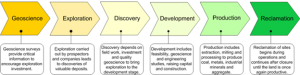
In British Columbia, the purchase of Crown land by a private landowner usually involves the exclusive transfer of surface rights. Subsurface rights, including access to minerals, natural gas, and petroleum resources, are retained by the province for disposition to individual prospectors or corporations. Mineral prospecting is prohibited on the following BC lands:
The first step to obtaining subsurface rights involves applying for a Free Miner’s Certificate. Any person of legal age who resides in Canada, or is legally entitled to work in Canada, will receive a certificate upon payment of a small fee. Once in possession of a certificate, a Free Miner has legal right of entry to any private or public lands designated as a “mineral zone” in order to conduct staking, the mechanism by which a prospector registers a mineral claim with the province. A Free Miner may use the Mineral Titles Online system to register a claim without conducting a site visit. Staking requires no consultation with affected landowners or the Crown. After registered, a claim can be maintained indefinitely provided a modicum of assessment is conducted annually. Approximately 85% of the province is available for staking by a Free Miner.
The preferential access to land by Free Miners is a tenet of the Free Entry System. Under s. 14(1) of the Mineral Tenure Act, after a Free Miner has registered a claim, that person “may use, enter and occupy the surface of a claim or lease for the exploration and development or production of minerals.” Exploration is conducted by a claim holder to determine the location and quality of potential mineral deposits. Preliminary activities involve surveying, road and trail construction, water sampling, and low impact drilling. In BC, a miner conducting exploration activities may disturb up to 1,000 tonnes of rock without triggering permitting requirements.
For more intrusive exploration activities, such as core drilling and camp construction, the MEMLCI is responsible for granting permits outlining environmental and safety requirements. Before carrying out such work, an exploration referral, termed Notice of Work, is distributed to various stakeholders who are afforded 30 days for comment. While a land owner cannot deny access to a claim holder, they may request compensation for disturbances occurring on property. Conflicts between parties are negotiated through the provincial government’s Surface Rights Board, who determines the conditions for rights of access and compensation; the Board cannot refuse exploratory access to a prospector.
If a Free Miner locates a viable deposit during exploration, they must apply for a mineral lease prior to commercial development of the claim. Provided the lease requirements are satisfied, the MEMLCI has no discretion to refuse an application. After a mineral lease has been granted, the proponent will usually negotiate to obtain surface rights necessary to access the subsurface deposit. This may involve significant compensation for private landowners or transfer from the Crown.
Prior to actual mine operations, the final stage in the Free Entry System usually involves an EA. An environmental assessment is triggered under the British Columbia Environmental Assessment Act (BCEAA) when anticipated mineral output exceeds 75,000 tonnes annually, or when the Minister determines the project will have significant environmental impacts. Depending on the scale of the proposed development, a joint EA may be conducted between provincial authorities and the Impact Assessment Agency of Canada (IAAC). EAs serve primarily to predict and mitigate the potential environmental impacts of a proposal, and to improve project design through consultation with stakeholders. An EA will also determine monitoring requirements for mine operations, and the procedures for decommissioning and reclaiming an exhausted deposit. EAs are important for establishing regulatory requirements that may have been overlooked in a proposal; however, it is uncommon for a mining development to be rejected outright during the process.
The allocation of property rights created by the free entry regime is especially salient for Indigenous peoples, whose traditional territories overlap significantly with mining operations and mineral deposits. According to the Assembly of First Nations, about 36% of all Indigenous settlements in Canada are within 50 km of a major mine operation. Furthermore, despite the duty to consult established in the Delgamuukw Supreme Court decision, the procedures for meaningful consultation are not well defined and, according to many Indigenous groups, are inadequate. Finally, since the majority of unextinguished Indigenous title in BC is not “proven,” Indigenous peoples are generally unable to exercise even the limited appeal mechanisms available to private land owners. Thus, the free entry provisions for claim staking, exploration, and mine development legislated under the Mineral Tenure Act may be viewed as potentially contrary to s.35 of the Constitution Act, 1982, which recognises and affirms Indigenous rights.
The inability of Indigenous peoples to participate meaningfully in the regulation and development of mining activities on traditional territories may also be in contravention of numerous international agreements to which Canada is obligated. These agreements include the International Covenant on Civil and Political Rights, the International Covenant on Economic, Social and Cultural Rights, the International Convention on the Elimination of All Forms of Racial Discrimination, and the United Nations Declaration on the Rights of Indigenous People.
Subsurface property rights also include oil and gas activities, including exploration and development. Like minerals, oil and gas activities are governed by legislation that cover a range of tenures. Key legislation includes Oil and Gas Activities Act(SBC 2008, Chapter 36), Pipeline Act (RSBC 1979, Chapter 328), Petroleum and Natural Gas Act(RSBC 1996, Chapter 361), among others. In addition, oil and gas activities, including exploration, development, pipeline transportation, and reclamation, must have specific approval from the BC Energy Regulator (BCER). The BCER is an independent, regulatory agency.
Under s. 72(1) of the Petroleum and Natural Gas Act, the Minister may withdraw Crown oil and gas reserves from disposition.
A mineral reserve or coal land reserve is an area in which subsurface activities are prevented or restricted (i.e., not allowed). A mineral reserve or coal land reserve is established by regulation under Section 22 of the Mineral Tenure Act and Section 21 of the Coal Act, respectively. Legally, a reserve is established to either prohibit registration (“No Registration” reserve) of a claim or to restrict the rights acquired (a “conditional” reserve). In relation to the “free entry” regime discussed above, when a No Registration reserve is established, a free miner must not register a mineral claim.
The concerns of Indigenous Nations go far beyond the negative environmental effects of mining. For many years, Indigenous Nations have raised fundamental concerns about how the governance of mining activities infringes Indigenous title and rights. The ‘free entry’ system is central to these concerns. Like elsewhere in BC (outside of protected areas), any person can stake a claim within the traditional territories of Indigenous Nations. Although legally permitted according to BC laws, this free entry process violates the requirement for free, prior, and informed consent under the United Nations Declaration on the Rights of Indigenous Peoples (UNDRIP). Nor is free entry consistent with BC’s Declaration on the Rights of Indigenous Peoples Act (DRIPA).
In the Yukon, the Ross River Dena Council took the government to court over the territory’s free entry system for mining claims. Ross River argued that free entry violated their rights. In 2013, the Court of Appeal of Yukon ruled in favour of Ross River, stating that the Territory must consult with unsigned First Nation governments before a mineral claim is staked on their traditional lands. A similar situation is taking place in BC.
In October, 2021, the Gitxaala Nation sued the Province of British Columbia over mining claims on Banks Island or Lax k’naga dzol, in the Gitxaala language. Here, too, the free entry system is a primary concern, with claims made in the Nation’s traditional territory without consultation or consent.
In 2022, the First Nations Energy and Mining Council (FNEMC) released a report, Indigenous Sovereignty: Implementing Consent for Mining on Indigenous Lands, that outlines 25 recommendations for how Indigenous Nations can assert governance over mining activities according to their own laws and traditions. The FNEMC present their recommendations as a set of “near-term practical” (p. 28) options for Indigenous Nations to exercise governance and grant consent within the framework of BC’s DRIPA, as an interim step as UNDRIP is implemented robustly. In this context, the recommendations address each of five stages of mining activities from staking claims to reclamation, as follows (from pp. 30-31).
IGBs [Indigenous governing bodies] should exercise statutory powers under the Mineral Tenure Act. This should be done exclusively by the IGB or jointly with the Province. The main statutory decision maker under the Mineral Tenure Act is the “Chief Gold Commissioner”. IGBs could establish an Indigenous equivalent to the Chief Gold Commissioner who could issue free miner certificates, cancel claims, or address conflicts related to claims. Changing the names of these statutory titles should also be considered. The title Chief Gold Commissioner does not have the same stature as a “Chief” in Indigenous governance. Moreover, the Chief Gold Commissioner is a misnomer as this position is responsible for more minerals than just gold.
IGBs should require a detailed engagement process be established prior to free miner certificates being issued. This engagement should include a knowledge-based assessment whereby the individual or company wishing to obtain a free miner certificate must demonstrate an understanding of Crown and Indigenous laws. Alternatively, free miner certificates could be abolished altogether, and replaced with an IGBs established knowledge-based assessment for any person seeking to explore for minerals on their lands (see Recommendation 4). If free miner certificates are continued, they should also be renamed.
IGB consent for a free miner certificate should limit free miner activities to the conduct of basic exploratory activities on Indigenous lands. It should be clear that the free miner certificate does not presume future activity or permits.
As IGBs strengthen their role in managing and protecting lands, IGBs could establish their own system for claim staking, which will be based on their own governance and values. This could include issuing their own mining certificates, perhaps by another name, and identifying the activities that will be allowed.
The Province’s mining laws generally enable a free miner to access surface lands as part of the subsurface claim. IGBs should consider approaches to surface land uses that are consistent with their own values. This could include restricting surface uses on their lands, or for example, expanding the use of Indigenous Protected and Conserved Areas.
Within a consent framework, the report acknowledges that Indigenous Nations will do some or all of the following:
46
LEARNING MODULE
In a relatively short period, the field of planning ranged from one extreme to another. We have embraced everything from technocratic determinism (in which we believe that we can fully know the future if only we had the right technology) to philosophical indeterminism (in which we believe that, at a fundamental level, we cannot know anything about the future). In the extreme, “indeterminacy, incommensurability, variance, diversity, complexity and intentionality” pre-occupied so much of planning’s theoretical developments that the “very notion of ‘planning’” was often questioned. For some people, the notion of planning is still questioned.
To make sense of planning theory as a whole, Allmendinger (2002) suggests two options: celebrating difference in order to keep debate completely open; and reconciling differences in order to improve understanding among varying perspectives. Whether celebrating or reconciling differences, the aim is to appreciate differences—not to eliminate them. Likewise, to reconcile differences is not to search for one answer but to understand the nature of such differences. Difference is not a basis for rejection; rather, it is, or can be, a basis for discovering and confirming meaning.
The following summary of planning theories uses Allmendinger’s (2002) survey of contemporary schools of planning as the primary point of reference. Allmendinger’s approach centres on the societal context for understanding the origin, use, and evolution of theory.
Allmendinger identified several schools of thought that have shaped planning over the past fifty years. These schools include the following:
Each school represents not a single theory but “a collection of (mostly) coherent and self-supporting theories/ideas/philosophies.”
This school is perhaps the most easily recognised and most commonly associated with planning. It is also well entrenched in a positivist worldview with strong beliefs in control and prediction, as well as a faith in technical solutions as the means for societal progress. While the historical foundations of positivism can be traced to the Enlightenment, society’s confidence in science- and technology-based planning grew in the post-war era of economic growth and urban development. The primary means of the planner-as-expert are modelling and logical, step-wise processes (e.g., identify problem, evaluate alternatives, select, implement, and evaluate). Planners in this school manage change by making decisions about human activities and urban systems (e.g., traffic flows, shopping patterns, commuting patterns). This planner-centric school is focussed on a knowable future, bounded only by available resources and technology, and guided by a desire for efficiency.
The new right school of planning is highly influenced by the political economics of the 1980s, most commonly known as Thatcherism and Reaganomics. Interest emerged after, and in relation to, the social liberalism of the 1960s and 70s. It is articulated as a solution to developing economic and political crises centred on mass unemployment, stagflation, and wage and price controls, not to mention the threat of communism and cold war politics. Although there is not a single view of planning within the new right school, which makes it difficult to sort through the details, it encompasses a liberal view of a person’s freedom to choose and of relying on the market as the mechanism for societal choices, both of which must be supported by an authoritarian strong state (conservatism). Philosophically, proponents of the new right hold high respect for private property, rational choice, and maximising utility. Under the axiom that ‘free’ markets are inherently superior to any other way of organising human societies, a good planner need only play a minimalist role – and let the market function unfettered.
Marxist thinkers present a critique of planning rather than a theory of or in planning. Primarily, Marxist planners focus on the limitations and problems of using planning as a tool of capitalism. The interest in Marxist theories can be viewed, at least in part, as a reaction to the consequences of post-war interests in consumerism and market values, such as urban sprawl, alienation, and increasing wealth inequality. From a Marxist perspective, the planning institution is either partially responsible for creating these conditions or is ineffective in dealing with the problems. Of greatest concern is the role that planners play in providing the conditions necessary for capitalism to reproduce itself, especially with regard to the allocation of urban spaces for the purposes of capital accumulation and the elimination of barriers to market functioning. In this capacity, planners are merely puppets of the market and its controlling interests. A planner’s task is to convince the public that the state is acting on its behalf. With regard to forethought, planning reacts to market conditions, which inevitably shapes the (future) conditions in which the market will operate. A shift from Marxist to neo-Marxist planning can be understood in part as a shift from a positivist view of class-based injustices to a post-positivist view of power-based injustices.
This school is often understood as ‘planning is what planners do.’ It is concerned more with practice than theory; but it is not just about doing things. Pragmatism is a particular philosophy predicated on a belief that truth is evident not in theories but in the usefulness of what one is doing. “We decide what to believe not because it corresponds to the reality of the world, but because an idea or belief makes sense to us and helps us act.” The emphasis on ‘making sense of the world through practice’ gives Pragmatism a short-term outlook that is best served through incremental rather than comprehensive planning. Agreement is the test of a policy’s correctness. There is no great goal or vision as much as a focus on day-to-day issues and problems, and the ability to plan is constrained by time and knowledge, in the practical sense of these terms.
This school is perhaps the least known and least developed. In contrast with the objective, technical pursuits of systems/rational planning, advocacy planning is deeply personal and highly political. This view of planning arose from the social disruption of the 1960s that included civil rights movements and marches, the war in Vietnam, and urban renewal projects that included extensive public housing and debilitating expressways through neighbourhoods. In this context, advocacy planning aims to bridge responsibilities between social justice and urban development. Rather than focus on what planners do, the driving question is for whom is the planner working. This question is guided by values, rather than science, thus privileging moral reason over scientific reason. The role of the planner, as an agent of change, is to represent the interests of unheard voices marginalised by formal planning processes, thereby helping more citizens to engage meaningfully.
Like the general postmodern movement, this school raises more questions than answers, thus falling short of stating clearly what planning is or should be. Notwithstanding this shortcoming, the questions raised by postmodern planners are critical to the future development of planning in the public domain. With concern for a more open and pluralist society, postmodern planners seek to expose society’s blind belief in such over-arching ‘meta-narratives’ as common values, value-neutral science, and the promise of progress Consistent with Marxist planners, they also question the relationship between governance, production, and consumption. Another meta-narrative questioned by postmodern planning is a guiding public interest. Many forms of postmodern thinking centre on individualism, thus ruling out the idea of a collective concern. Rather than focus on commonality, the emphasis is on difference.
Via its normative grounding in Habermas’ communicative rationality, collaborative planning, as the name infers, aims to cross many bridges between several aspects of positivist and post-positivist planning: (modern) rationalism and (postmodern) pluralism; celebrating differences and reaching consensus; comprehensive plans and participation/inclusion. A key element of this school’s philosophy is that its planners accept multiple forms of rationality, including both instrumental and communicative rationality. In this regard, the role of the planner is to create space for more discourse by questioning the dominance of instrumental rationality, which ‘crowds out’ other ways of knowing, such as communicative rationality.
Our brief summary of schools of contemporary planning thought drew upon Allmendinger, which in turn, drew upon a wide range of original text. General areas of concern within the literature provide useful cross-cutting themes to examine the field as a whole. How each school of planning views these concerns points to critical aspects of its foundations, including worldviews. For our purpose, these areas of concern can be stated as a set of questions:
What decisions do planners make (i.e., what is their primary area of responsibility)?
What is the role of a planner in the decision-making process?
To what extent is a planner concerned with the future?
What does a planner know about the future? To what extent is the future predictable? Or is it unknowable?
Is there a (shared) public interest that guides planning? If so, what is it?
Our analysis of the schools of planning involves using the above set of questions as cross-cutting themes to reveal how each school addresses the core concerns of planning. The results of the analysis are summarised below in Table 1. Defining elements of each school can be read across each row, while an entire row provides a summary view of each school. Each column represents a cross-cutting theme, whereby it is possible to identify similarities and differences by each area of core concern.
The following discussion is organised by each of the questions. The aim of the discussion is to highlight similarities and differences, as well as their implications for planning in the public domain.
Combing through the literature, it is difficult to isolate specific questions that each school of planning addresses. Notwithstanding this challenge, it is possible to reflect on some differences with regard to general areas of responsibility. The schools of thought that most clearly articulate its central decisions were the positivist schools of systems/rational and new right. Marxist, as a critique of these two schools, followed suit. Several schools of thought are explicitly aligned with land use decisions, including systems/rational, new right, and pragmatism. New right, via its belief in the market as society’s primary choice mechanism, is explicitly focussed on planning decisions that affect land use, but the directive is to ensure that such decisions are minimal, regarding both influence and scope. For pragmatists, land use decisions are a significant feature perhaps because these decisions are visible to the public, thereby demonstrating that planners are doing legitimate work. Advocacy, postmodern, and collaborative schools of thought are more concerned about the decision-making process than about decisions. They still make decisions, but such decisions relate to who should participate, how multiple interests should be engaged, and what should be up for discussion.
With reference to Table 1, a quick glance down the column under roles of planners in decision-making processes demonstrates a range of possibilities. Many of these roles stand out as defining features of their respective schools. The planner-centric expert of systems/rational presumes a great deal of responsibility and influence through its decisions. The Marxist view of planners as “puppets of the market” provides a quick and easy summary of its critique. The ‘do little and stay out of the way of the market’ is reflected in the new right’s role of the planner as minimal. The advocacy planner’s role is to advocate on behalf of the marginalised voices. The postmodern role of narrator is perhaps the most intriguing, for it reflects a fundamentally different conception of planning as a discourse. The primary role of the collaborative planner is to facilitate collaboration among all stakeholders through educating, providing information, and creating forums for open discussion.
A shift away from a focus on the future to a focus on the present is evident as one reads down from the top of the column. These differences reflect the shifts from end-states to process, from positivist to post-positivist worldviews, and corresponding shifts from instrumental to communicative rationality. Most broadly, they reflect similar changes in society.
One reason why the future is less of a focus in planning is a growing lack of confidence in our ability to know the future, thus accounting for a shift from technical determinism to philosophical indeterminism. However, a mediating factor is a focus on the market, especially for the new right planning school. This school believes that because society is too complex for planning it is best to leave the future to the spontaneous ordering of the market. The future is ‘visible’ to the extent that market trends can be analysed and crises can be anticipated. Postmodern and collaborative planning also think that society is too complex; the response is to focus less on comprehensive planning and more on present problems. Pragmatist planners prefer to rely on their intuition.
From a professional perspective, debate about the public interest is important for many reasons, including questions about for whom one plans, and also moral questions about social order and good governance. However, philosophical differences among schools of planning thought provide a range of responses to these questions. The difference between systems and rational planning reflects an important question of for whom does one plan in the public domain. For systems planners, the interest of the public is represented by pre-defined goals, and these goals become part of a system model. The model seeks out the most efficient means to achieve the most desirable ends. Rational planners keep the means and ends separate, believing that the public interest falls within the realm of politics, not planners. Thus, systems planners plan for the public; rational planners plan for politicians. While both schools are positivist, the relation between ends and means serves to place a planner in different positions vis-à-vis the public interest. Meanwhile, the objective stance of systems and rational planning has been the subject of criticism by other schools of planning thought, which believe that planners cannot be neutral. This is most evident in the school of advocacy planning. Further, the shift away from neutral planning corresponds with pluralist worldviews, whose emphasis on difference precludes the possibility of a common good or a public interest. Marxist planners offer another perspective of the public interest, that the idea of a ‘public interest’ is part of a false consciousness that serves to placate citizens such that they believe that the state is serving their interests.
Table 1. Schools of planning thought: analysis by areas of concern
PHILOSOPHY What is the planner’s worldview? | PURPOSE What decisions do planners make (i.e., purpose)? | ROLE What is the role of the planner in making decisions? | ORIENTATION To what extent is planning oriented to the future? | FORESIGHT What does a planner know about the future? | PUBLIC INTEREST Is there a public interest that guides planners? | |
Systems theory/ Rational comprehensive | Positivist: scientific, objective, rational, empirical | Land uses; human activities, patterns, and flows; control change | Planner-centric expert | Strong | Can be predicted | Systems: yes; set goals are inputs for models. Rational: yes, but outside the domain of planning. |
Marxism/ | Political economy; positivist with shift to post-positivist | Critique: land uses; accumulation, distribution, and the role of the state | Puppet of market | Critique: too strong | Market-driven | It is a false consciousness to justify maintaining the status quo |
New Right | Positivist view supports economic determinism; a combination of a market-orientated competitive state (liberalism) and an authoritarian strong state (conservatism) | Land uses; neighbourhood effects (e.g., noise pollution) | Minimal; provide conditions for the continuation of the market mechanism | Moderate; defer to the market mechanism; anticipate barriers to market function | Can foresee barriers to market functions | Maximise public good by maximising freedom for people to make their own choices in a free market society |
Pragmatism | Pragmatist: truth is a self-evident measure of what is working | Land uses | Act on ideas or beliefs that make sense and help others to act | Weak; spontaneous order | Intuition; the outcome of using an idea | Impossible to aggregate |
Advocacy | Post-positivist; feminist | Solutions to address power inequalities | Advocate | Weak; focus on present injustices | A matter of choice | Pluralist, but commitment to social justice |
Postmodern | Post- (or anti-) positivist; rejects rationalism | Focus on and release ‘difference’ | Narrator | Weak; focus on day to day | Weak: rejects objective knowledge | Fragmented, pluralist, and atomistic |
Collaborative | Post-positivist: accepts multiple forms of rationalism | Process: create space for discourse; agreement through free and open discourse | Facilitate collaboration among all stakeholders | Moderate; pluralistic | Points to the future, but does not define it; revealed through communicative action | Pluralist; but lifeworld and public sphere point to a public interest; achievable levels of mutual understanding |
The results of the analysis indicate there are differences regarding who makes planning decisions, as evident in the different roles of planners that help distinguish each school of planning thought. As the role of the planner changes from expert to facilitator the focus changes from planning to managing. Whereas planning is oriented to the future, managing is oriented to the present, which infers that not all planners focus their attention on planning, in a strict sense of the term. Furthermore, knowing the future is not the exclusive domain of positivist planners. That is, planning theorists are not at odds over a discernable future; they are at odds over the extent to which the future can be known. What also concerns post-positivist planners is who is doing the predicting, forecasting, and determining.
Changes are also taking place with regard to how planning is organised in the public domain and to how planning is viewed by society. Instead of arguing whether the professional planner should be either an expert or a mediator, the opportunity is to look beyond the domain of professional planning practice in order to gain insight to planning as a social phenomenon. The role of the planner and the decisions planners make may reflect changes not wholly within the field of planning but reflect broader changes taking place within the societal organisation of planning. For example, a local government undertakes planning as a complete process, whereas professional planners working for a local government may only contribute to parts of this process, of which one part is managing the process. Furthermore, changes in society’s capacity for planning are reflected in elements concerning the future and public interest, as these elements are not restricted to the domains of planners and local governments but reflect broad societal values and beliefs.
From a pluralist perspective of planning theory, the emphasis on difference, relativism, and uncertainty focusses planners’ attention on the present and the many voices of a fragmented society. In an extreme form of pluralism, one could argue that planners can do without a definition of planning, or that there is no ‘planning.’ Yet the contrasting schools of planning thought should not be dismissed as merely competing theories. By focussing on differences it is easy to lose sight of common aspects of planning that bind these disparate views.
The insights generated from our analysis affirm that we can learn something about the nature of planning as a social phenomenon, thereby contributing to the theoretical foundation upon which further discussion about differences can take place. However, not all differences can be reconciled, particularly those that are bound to worldviews or specific societal contexts. Collaborative planning is moving along a path of reconciliation by trying to accommodate both positivist and post-positivist approaches.
Notwithstanding the inherent challenges, to move beyond the limits of focussing strictly on difference, we must be willing to engage in discussion about the core concerns of planning. To focus on common concerns we must also be willing to separate theory from practice, the descriptive from the normative, and explanation from ideology. There is room to celebrate difference, but we cannot do so at the expense of undermining the ‘very notion’ of planning.