Main Body
Competing Views of the World in Early Modern Japan
Radu Leca | Kyoto Institute, Library and Archives
Explore the maps used in this essay, along with over 500 additional maps and atlases, in the UBC Library Open Collections Japanese Maps of the Tokugawa Era digital archive.
A bi-dimensional map is necessarily an imperfect approximation of the three-dimensional shape of the globe, and so a world map centred on Europe is equally ‘valid’ as one centred on Asia. Given the propensity of humans to centre their spatial knowledge on their immediate surroundings,[1] this should result in an equal distribution of world maps centred on the place of origin of their authors. However, when in the 1980s the Parochial Views of the World study analysed thousands of maps of the world drawn by first-year geography students in universities across the world, it found that 79% of the maps were Eurocentric.[2] This is due to historical and cultural factors that include the adoption of the Greenwich-centred world map as standard in 1884 at the height of the British Empire.[3]
The sheer variety of the world maps included in that study reveal that our perception of the earth’s surface is at the same time subjective and shaped by the historical and cultural context. Such maps are not concerned with accuracy in the sense of corresponding to scientific data about the earth’s surface. They are however accurate in their portrayal of thought patterns. Maps of the past also constitute rich sources for understanding the history of thinking about space. But they are often dismissed as unimportant. This is because the study of maps in history has often been undertaken by historians of science or by geographers concerned with advances in topographic accuracy. This is true also in the study of the history of Japanese maps. In 1983, for example, Jacobs concluded her thesis on world maps in the UBC collections with the bleak conclusion that Dutch world maps did not have as large an influence in Japan as would be expected.[4] That conclusion was based on a teleological concept of scientific knowledge spreading from Europe outwards. What that conclusion did not consider was the parallel system of knowledge that was evolving inside Japan. It was made up of Neo-Confucian intellectuals, Dutch Studies scholars, and Buddhist monks. The Rangaku 蘭学 (‘Dutch Studies’) scholars received Western knowledge directly through access to and translations of Dutch books obtained mainly through the Dutch trading post on Deshima, the sole point of trade with only the Dutch. Confucian scholars, on the other hand, relied more on the precedent of a map of the world initially produced by the Jesuit missionary to China Matteo Ricci, or on maps brought in through other trade routes with South and Southeast Asia.
An alternative approach to the study of historical maps has emerged in the last decades, reconsidering the networks and mentalities that produced maps.[5] Here I would like to illustrate the usefulness of that approach for cultural history by using examples from the UBC collections. For brevity, let’s focus on two issues: the first is the variety of uses and meanings that the world map had in early modern Japan. To discuss this I purposely choose maps that do not fit into the received narrative of cartographic history in Japan. The second issue is how the uses and meanings of world maps changed after the middle of the nineteenth century, when Japan entered a phase of rapid modernization.
To understand the role of world maps in East Asia, a brief review of pre-existing developments is necessary. An important premise for thinking about geographical knowledge in Japan is the fact that for most of its history, the main point of reference for Japanese culture and thought was the continental culture typified by Confucian and Daoist classics and Buddhist sutras translated in Chinese script and other narratives. Until the sixteenth century, in Japan these references mostly related to an idealized Tang period. Its world view was that of a Central Kingdom surrounded by uncivilized nations. In other words, space was defined concentrically in terms of the civilization level of its inhabitants.
This world view was updated at the end of the 16th century by Jesuit proselytizers who used geographical knowledge for persuasiveness. This resulted most notably in a customized world map written in Chinese by Matteo Ricci, a version of which appears in figure 2. Although hailed by previous research as a progress in geographic knowledge, this map also overlapped neatly with the established concept of the Central Kingdom, and the pre-existing tradition of encyclopaedic knowledge. It was thus adopted as expressing the world view of Neo-Confucianist scholars, who came to dominate the official intellectual discourse in Japan beginning with the seventeenth century.
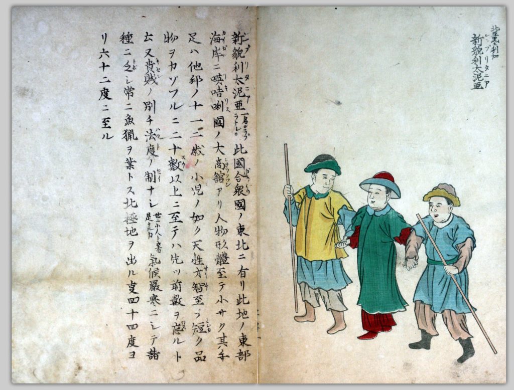
In the latter frame of thought, geographical knowledge was organized indexically as information associated with specific lands and their inhabitants [Figure 2]. For example, an 1855 illustration of a country from the American continent was accompanied by the following text: ‘Otherwise called Labrador, this country lies to the northeast of the United States, and on its eastern shore is a large trading post of Igirisu (‘England’). They say that all the people’s features are small: their hands are like that of twelve-thirteen year old kids, they are naturally clever, but when they have to count small objects they can’t remember more than twenty. They don’t have regulations separating the high from the low classes. Could this be the so-called Kobito 小人 (‘Small People’)? The climate is extremely cold, and they are missing many things [of use]. They are often fishermen. They are situated between 44 and 62 degrees from the North Pole.’ The author was trying to insert an update to geographical knowledge into the pre-existing category of the ‘Small People’ that had appeared in Matteo Ricci’s world map.
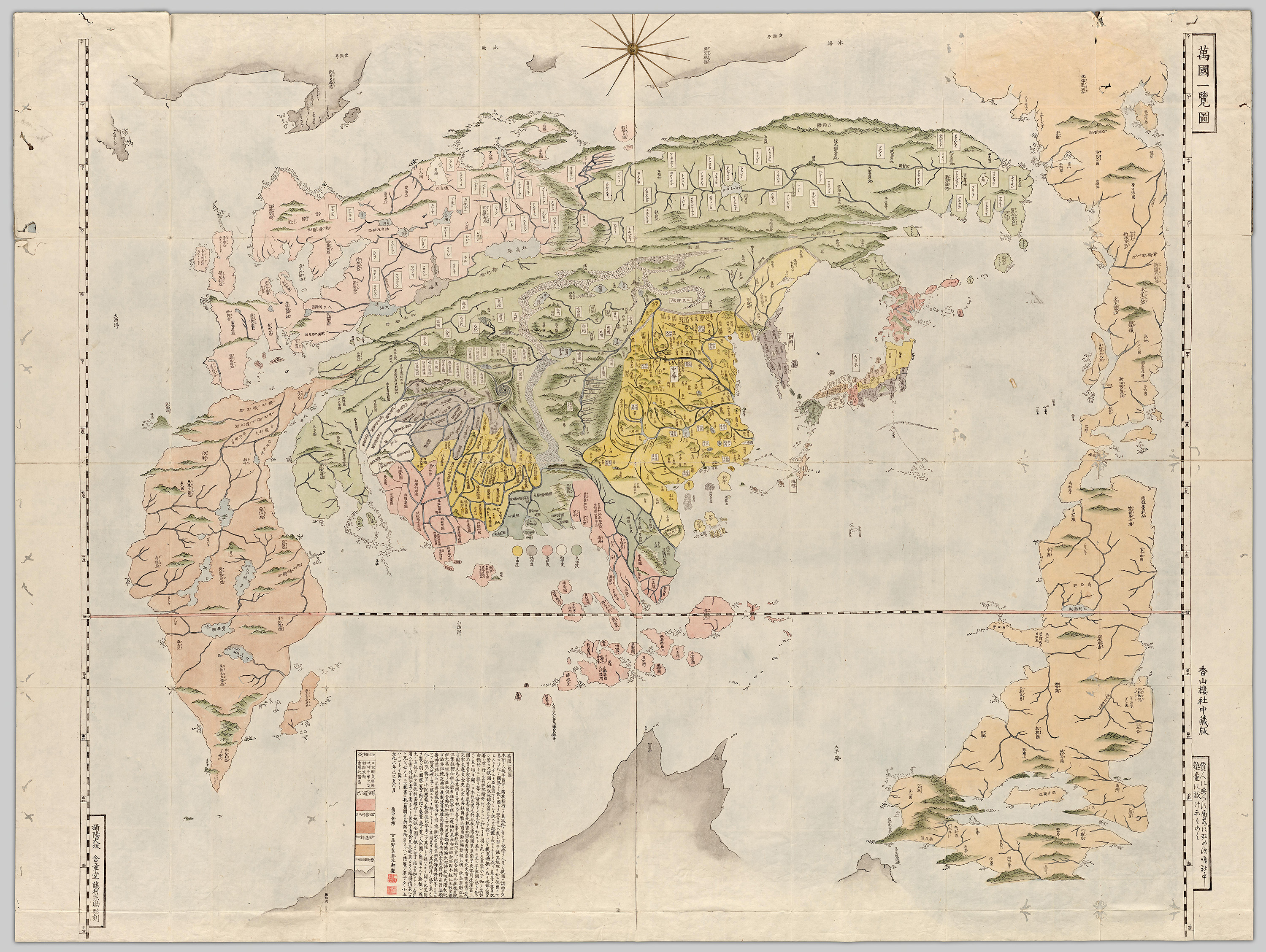
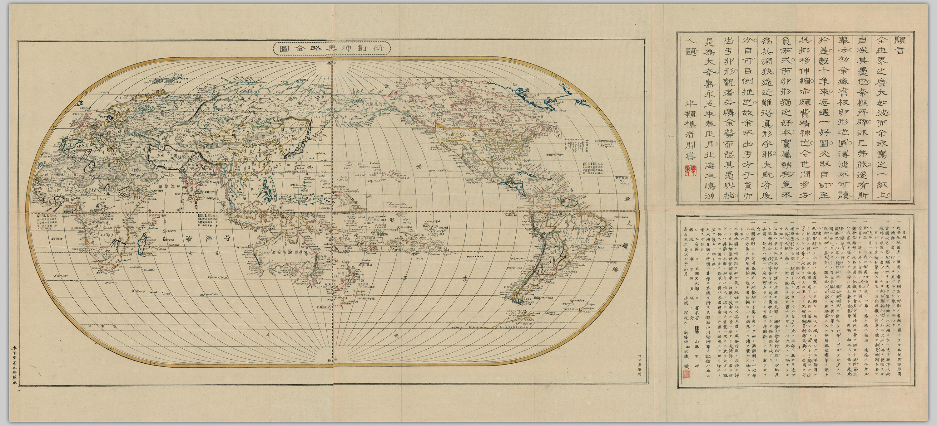
When it came to the actual Ricci-style maps, their use was reassessed when newer Dutch or French double-hemisphere projections became available at the end of the eighteenth century. A good example of a synthesis of various sources is a map of the world by a Neo-Confucian teacher from the small town of Kurashiki [Figure 3]. It mixes the toponyms from Ricci-style maps with toponyms from Buddhist world maps[6] and with newer data from Western maps such as Australia as ‘New Holland.’
The map was printed in Osaka, but a text on the map spells out that it is ‘not for sale and shown only to pupils in our private school’. In the preface of the associated explanatory text, Koyano writes that the double hemisphere world maps were too difficult to understand for beginning students, for which he prepared a simpler view of the world at a glance.
Therefore, for Koyano at least, there was a hierarchy of views of the world, appropriate for teaching to different levels of intellectual formation. Koyano’s world map was a specific mix of knowledge intended for pedagogic purposes. For a pupil, this would consist largely of copying various writings, including maps. One could imagine it was not an extremely enjoyable activity. So it is understandable that a probably bored student omitted to copy an island to the west of ‘New Holland’, and instead transcribed only part of the caption, in the process modifying it slightly to spell ‘Pig Eats Lion’.[7][/footnote]
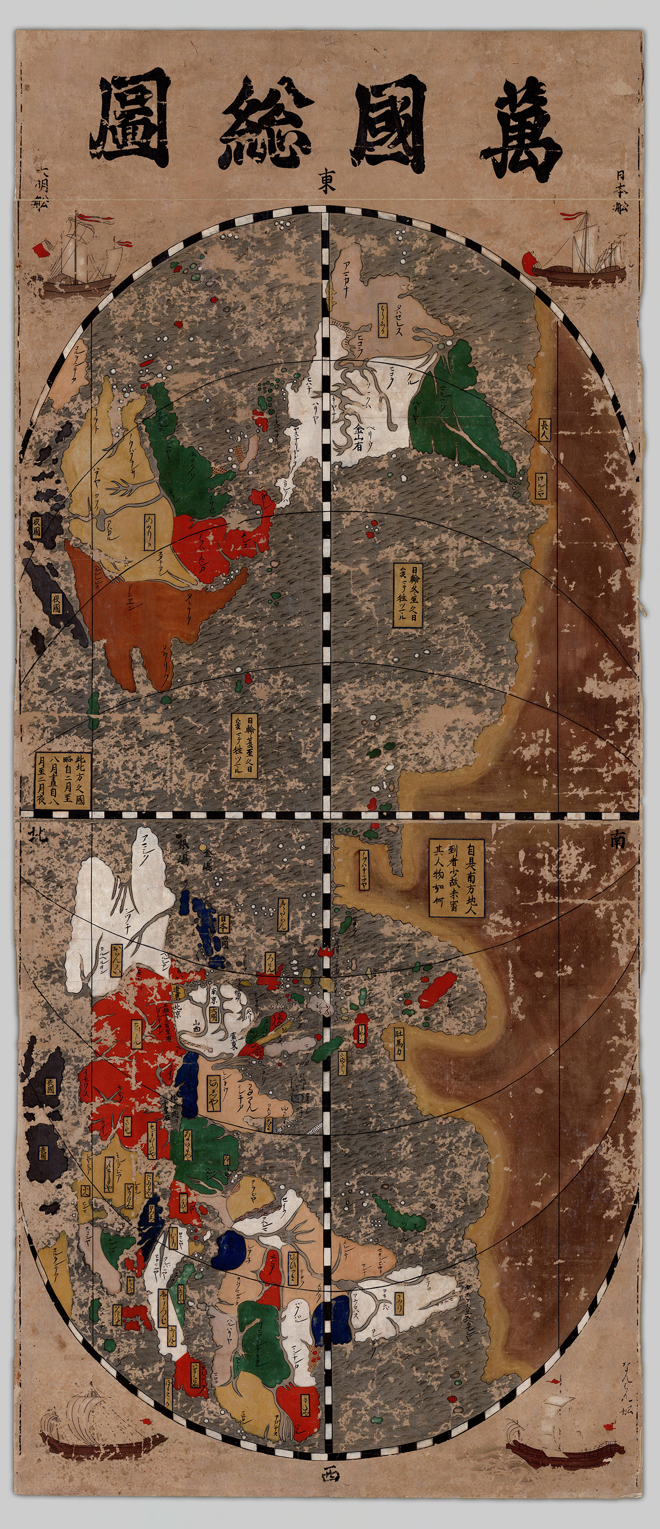
Other manuscript world maps from the same intellectual environment are further removed from the image of the world as we visualize it now. [Figure 4] But rather than dismissing them, we need to understand that they do not depict topography but rather mental connections that form a hierarchized topology, tied by unfamiliar routes. From this point of view, such world maps are snapshots of the mental landscape of intellectuals at the time.
A generation later, the range of knowledge on earth’s shape widely available just before the 1853 visit by Commodore Perry’s squadron is illustrated by the colophone of a copperplate-printed world map:
This is an egg-shaped map, and the land shapes lose their accuracy around the two poles. In the case of a double hemisphere map, the centre is compressed, while in a flat map the longitude lines widen the closer one gets to the poles. I would like the viewers to understand that and not think it odd.
World maps are not just toys to know land shapes. They are necessary to know each country’s customs, products, and the location of places where brave men fought. That’s difficult for those without detailed knowledge. I made this map for everyone to use and for the convenience of children. If I’ll have time to make another map, I’d like to compile detailed maps for each country, to help with reading the history of the world.[8]
Again, the Ricci-style ‘egg-shaped map’ is compared to the double-hemisphere map, but the breakdown of the flaws of various projections puts them on an equal par, with no political associations to Holland or China. This is followed by a clear exposition of the map’s purpose of disseminating knowledge. Although the study of the history of the world is mentioned, there is no reference to foreign sources as informing that knowledge.
This attitude changed in the next decade: in 1860s Japan, world maps started to take on a pragmatic character. Due to the increased availability of travel outside the Japanese archipelago, world maps now showed lines of possibility and anticipation for Japanese readers [Figure 6]. Such copperplate-printed world maps were usually translations of European or North American maps. This was not new, but, crucially, the foreign origin of geographic knowledge was now highlighted: foreign pedigree became a selling point.[9]
The map in Figure 6 is a translation of a Dutch map[10] which is a continuation of Edo period practice, but also marks the end of an era: this is among the last Dutch maps to be translated in Japan. From then on, British maps and the English language would serve as references. Tellingly, this map’s prime meridian crosses through Washington D.C. This is also one of the first maps on which Japan appears coloured in red (on the initial map it was in lavender colour). Colour-coding was not standardized before this period, and the red colour can be seen as corresponding to the new flag of the Japanese empire, which was also standardized around this time and is featured prominently in the title.
Interestingly, the island of Sakhalin, which was disputed with the Russian Empire, is coloured orange, an intermediary hue to red. The same red is used to highlight a specific sea route leading from South China through the Malacca Straits, South India and the Red Sea with an overland section to Cairo (The Suez Canal would only be completed in 1869). This was the main access route for Japanese travellers to Europe. The 1864 Japanese embassy to Paris followed this route, and upon meeting the scholar Phillip Franz von Siebold, the vice-ambassador Kawazu Sukekuni gifted him a copy of this same map.[11] World maps were now used as tools of international diplomacy.

After the Meiji Restoration in 1868, being conversant in the geography of the world was one of the prerequisites of being a modern citizen of Japan. But not all geographical knowledge came from Europe: a 1871 work about the United States, for example, featured both a ‘one glance’ view of the world as well as a double-hemisphere projection. It was essentially the reprint of a work written in Chinese by Bi Ziwhen裨治文, sinicized name of Elijah Coleman Bridgman (1801-1861), the first American Protestant Christian missionary appointed to China.[12] At the back of the last volume is a list of works available from the same publisher.[13] One third of these titles are of maps or geography-related books, which speaks to the importance of this topic in the period. The list is followed by an inscription that translates roughly as: ‘On the left is a catalogue of newly published books brought by foreign ships, including illustrated explanations of the celestial and terrestrial globe, as well as various other books that must be read now. They are issued every month, and willing gentlemen from any corner of the land can consult them.’[14] What is significant here is that although there was unprecedented access to information about the outside world, this information was still often packaged in the writing format of neo-Confucian traditional knowledge. Even the audience was phrased in terms of the Confucian ideal of the superior person (junzi 君子). Coupled with the lack of standardized teaching manuals for the newly established education system, this led to a plurality of cartographic solutions between worldviews. This situation gave way after 1890 to a more nationalistic geographical discourse encouraged by the Imperial Rescript on Education. Manuals on geography would be increasingly standardized and would impose a new learning system that would eventually replace the neo-Confucian paradigm.
Just like the mental maps of the world that began this argument, maps of all periods and regions show that the world is always drawn according to a particular person’s worldview as a response to other participants in his social network. When we consider the variety of world maps in early modern Japan, they show us that mentalities did not change so easily and immediately after the availability of Western maps. They configure a parallel history of visualizing the globe that needs further investigation, starting from other maps in the UBC collections.
- See Yi-Fu Tuan, Topophilia: A Study of Environmental Perception, Attitudes, and Values (Englewood Cliffs, N.J.: Prentice-Hall, 1974). ↵
- Thomas F. Saarinen, “The Eurocentric Nature of Mental Maps of the World,” Revista Internacional de Ciencias Sociales y Humanidades 9, nos. 1&2 (October 1999): 259, http://revistasociotam.campuscemir.mx/ojssociotam/index.php/SOCIOTAM/article/view/152 ↵
- See Charles W.J. Withers, Zero Degrees – Geographies of the Prime Meridian (Cambridge, Mass.: Harvard University Press, 2017). ↵
- Elisabeth Maria Jacobs, “The Red-Haired in Japan: Dutch Influence on Japanese Cartography (1640-1853)” (M.A. Thesis, The University of British Columbia, 1983). ↵
- See J.B. Harley, The New Nature of Maps: Essays in the History of Cartography (Baltimore MD: Johns Hopkins University Press, 2001). For a recent application of new approaches to the history of maps in Japan see Kären Wigen, Sugimoto Fumiko and Cary Karacas, Cartographic Japan (Chicago: University of Chicago Press, 2016). ↵
- Such as Hōtan, Nansen bushū bankoku shōka no zu 南瞻部洲萬國掌菓之圖 (‘Map of the countries in Jambudvipa’), 1710, woodblock print, 113.1 by 142.2 cm, University of British Columbia. Library. Rare Books and Special Collections. G3201 S2 1710 H6. ↵
- Manuscript copy of Bankoku ichiran zu by Ueki Naoki, Nanba Collection, Kobe City Museum. ↵
- 一、此圖卵形ニシテ兩極規外ノ地勢殆ンド真ヲ失フガ如シ兩圓圖ノ中心縮小シ平方圖ノ經度兩極ニ近キ者延擴スルト同患ナリ請フ覧ル人怪ムコト勿レ 一、凡輿地圖ハ唯地形ヲ知ル為ノ玩物ニ非ズ其各國ノ風俗所産ノ品物ヲ詳ニシ又英雄豪傑割拠闘争ノ故蹟ヲ捜索スル等ニ要タリ是精詳ノ者ニ非ザレハ得難シ本圖ノ如キハ唯人ノ求ニ因テ童蒙ニ便ニス敢テ大方ノ觀ニ供ヘズ予復刀圭ノ餘暇フ得バ各國精密ノ分圖ヲ嗣成シテ世人海外ノ史ヲ讀ム一助ト為ン. ↵
- Copperplate was a novel technique in Japan. Some printers had done it in the preceding decades, but such prints were rather objects of curiosity. In the 1860s, copperplate prints started instead to be treated as serious objects, and the copperplate technique was seen as one of the technologies that needs to be taught by foreign experts such as Edoardo Chiossone. Peter Kornicki, The Book in Japan (Honolulu: University of Hawai’i Press, 1998), 168. ↵
- J. Kuyper, Wereldkaart, naar en met de laatste ontdekkkings-reizen, opgedragen aan de to Nederlandsche Handel-Maatschappij (Amsterdam: C.F. Stemler, 1857). The Maritime Museum in Amsterdam holds a hand-coloured world map by Stemler, dedicated to the firm that succeeded the Dutch East India Company, the Nederlandse Handelmaatschappij, viewable at http://www.maritiemdigitaal.nl/index.cfm?event=search.getdetail&id=101003313. It is probably through that route that such a map made its way to Japan. ↵
- Kokuritsu Rekishi Minzoku Hakubutsukan, ed., Yomigaere! Shīboruto no Nihon hakubutsukan (Kyoto: Seigensha, 2016), 144. ↵
- Fred W. Drake, “Protestant Geography in China: EC Bridgman’s Portrayal of the West”, in Christianity in China: Early Protestant Missionary Writings, ed. Suzanne W. Barnett and John King Fairbank (Cambridge, MA: Harvard University Council on East Asian Studies, 1985), 89–106. ↵
- 博物新編、六合最談、全體新論、省諐録、新刊輿地全図、同和解、鄭板橋詩鈔、日本沿海圖、萬國公法、西醫畧論、六大洲分文割圖、地球説畧、内外新説、西洋算法分數術、聯邦志略、婦嬰新説、西洋算法此例法. ↵
- 右之外舶来新板書籍天球地球圖解其他方今必讀之諸書月々發兌希四方諸君子多披閲. ↵
