13.4 Mountain Building
While some mountains are volcanoes and form when molten rock erupts on Earth’s surface, faulting and folding on a large scale also build mountains. In fact, the majority of mountain building on Earth is from folding and faulting rather than from volcanic eruptions.
The type of stress acting on rocks will determine whether folding will happen and what kind of faults will form. Plate tectonic processes are what determine the overall stresses acting in a region, and different processes occur in different tectonic settings. What this means in the big picture is that plate tectonic setting determines what kind of mountains will form.
Mountain Building Along Convergent Margins
Ocean-Ocean Collision
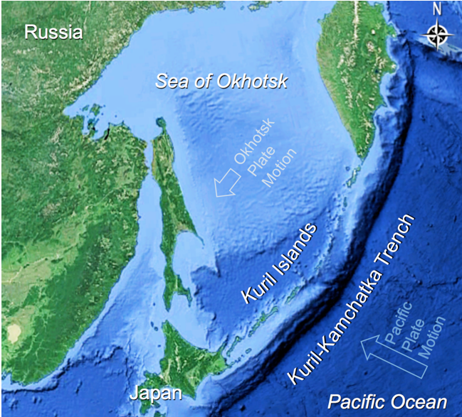
Volcanic island arcs are mountain chains made of volcanoes that form along subduction zones where two oceanic plate margins collide. The Kuril Islands (Figure 13.32; view in Google Earth) are an example. The Kuril-Kamchatka Trench marks a subduction zone where the Pacific Plate is being subducted beneath the Okhotsk Plate.
Ocean-Continent Collision
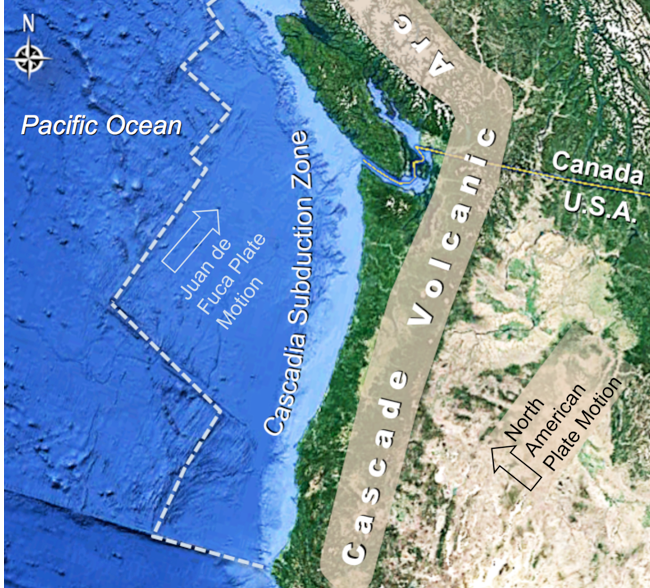
Continental volcanic arcs form along subduction zones where oceanic plate boundaries collide with continental plate boundaries and subduct beneath the continental boundaries. The Cascade Range (Figure 13.33) is an example of a continental volcanic arc. It has formed because of the subduction of the Juan de Fuca plate beneath the North American plate.
While volcanoes are an important feature of these mountain chains, folding and faulting of continental rocks are also important. The process of producing long mountain chains when tectonic plates collide and deform is called orogeny. Mountain chains formed in this fashion are called orogens.
The Sierra Nevada mountain range in Utah and Nevada (view in Google Earth) was formed by an orogeny that began around 140 million years ago. The mountain range was built up by igneous intrusions and volcanic eruptions along a continental volcanic arc (Figure 13.34). The terrain was altered further inland as well. Sheets of rock were thrust on top of each other, and pushed inland along a detachment fault, similar to the example of the McConnell Thrust in Figure 13.29.
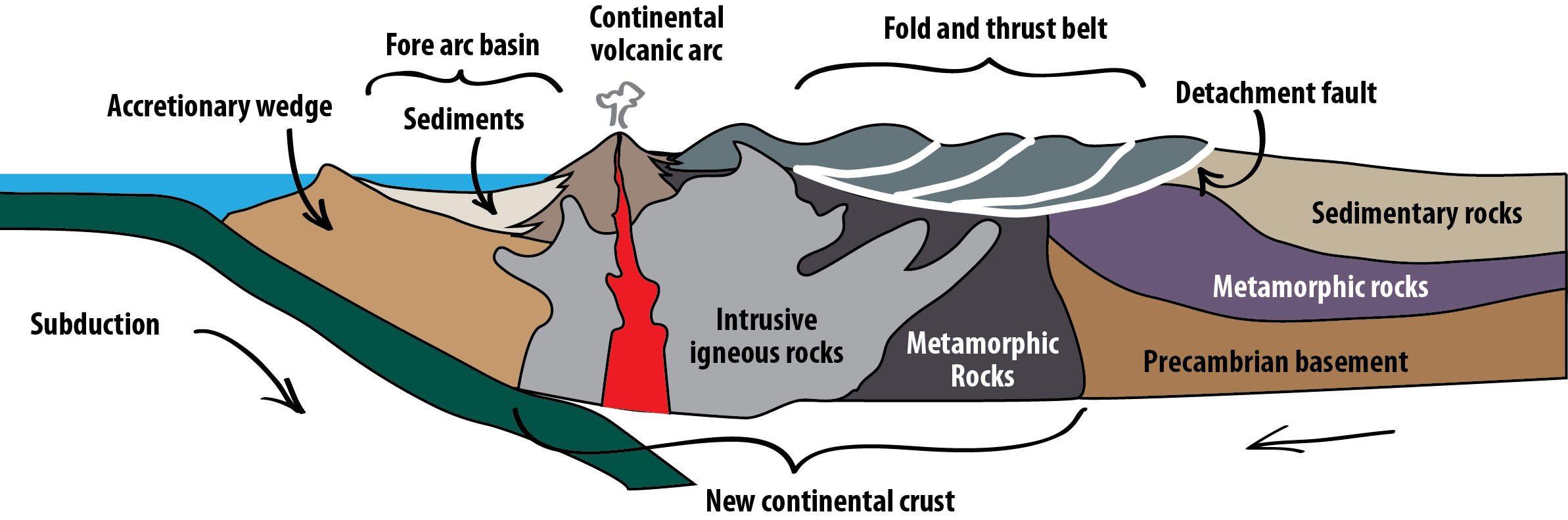
The continental crust flexed downward because of the weight of the mountains, and this formed a fore arc basin seaward of the new mountain range. Sediments accumulated within that basin. The leading edge of the continent also collected sediments and igneous rock scraped off the subducting plate, forming an accretionary wedge. Over time, the force of the collision would smash the basin sediments and the accretionary wedge against the continent, turning it into new continental crust.
Continent-Continent Collision
When two plate margins of continental crust collide, the mountain chain that forms is a result only of folding and faulting of rocks, not volcanism. The Himalayas (Figure 13.35) are an example of a mountain chain formed by continent-continent collision. The collision also raised the plateau to the north of the Himalaya mountain chain.

The Alleghenian Orogeny, which brought together North America and Africa in the process of forming Pangea, is an example of mountain building in a continent-continent collision zone. Before the continents came into contact with each other, mountain building on the eastern coast of North America would have involved deformation from an ocean-continent collision, as with Figure 13.34. But as subduction proceeded, the subducting plate drew Africa closer and closer to North America. The gap between the two continents began to close, and fill with sediments (Figure 13.36, top).

While a subduction zone existed, the addition of water to the mantle permitted partial melting of mantle rocks, and thus volcanic activity. However, when the two continents collided, the subduction zone closed off and volcanism was no longer possible. As the continents smashed together, deep faults formed and stacked blocks of crust on top of each other. Old faults were reactivated. Rocks also began to shift along the boundary between an earlier orogen—the Taconic Orogen—and North America (Figure 13.36, bottom). When the continents had finally merged, Africa met North America along a suture zone with remnants of a continental volcanic arc on one side, and folded and faulted sedimentary rocks on the other.
Orogens Are Everywhere!
Orogens can be found around the world (Figure 13.37, in cyan). Orogens along the edges of continents or in oceans indicate places where mountain belts are forming along subduction zones. Orange zones are shields: regions where the ancient stable basement rock (called a craton), is exposed. Pink zones are platforms, where the craton is covered with sediments and sedimentary rocks. Where orogens are present in the midst of shields and platforms, this indicates a place where two continental plate margins have collided, and the plates merged to form a single large continent.

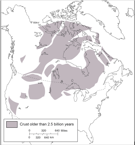
What is classified as a craton depends on the timeframe under consideration. The regions in Figure 13.37 identified as shields and platforms are in fact comprised of crust stitched together by ancient orogens. The shading in Figure 13.38 shows what part of North America consists of cratons (stable crust) older than 2.5 billion years. The gaps between the cratons are filled by orogens that have stitched the cratons together. Even these ancient cratons consist of older pieces of crust sutured by orogens.
Mountain Building Along Divergent Margins
Where plates are thinning and separating, systems (groups) of normal faults form. Mountain ranges can form when faulted blocks tilt backward or are lifted relative to the surrounding rock. Blocks that are elevated compared to adjacent blocks can form another type of mountain, called a fault-block mountain. Fault block mountains formed in eastern North America when Pangea began to split up, and Africa pulled away from North America (Figure 13.39).

Over time, elevated blocks erode, filling up valleys with sediment. The thinning of continental crust that occurs with rifting can decrease the pressure on mantle rocks enough to trigger partial melting. Magma can move up along the normal faults, forming igneous intrusions, or feeding volcanoes. The Palisades Sill in New York and New Jersey is a result of rift-zone magmatism. It is a cliff-like feature resulting from erosion that exposed the tip of a structure like the sills in Figure 13.39. Mountain building that combines faults and volcanic activity from decompression melting is currently happening in the East African Rift Zone.
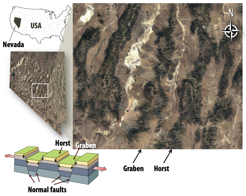
Another location you can see fault-block mountains is in the Basin and Range Province in Nevada (Figure 13.40). Stretching of Earth’s crust has resulted in a series of normal faults in a horst and graben arrangement. (Horsts are fault blocks raised higher, and graben are blocks that fall lower). In the region shown in Figure 13.40, the dark green linear features are vegetation-covered horst mountains, and the tan coloured features are graben valleys filled with sediment.
Intraplate Mountain Chains
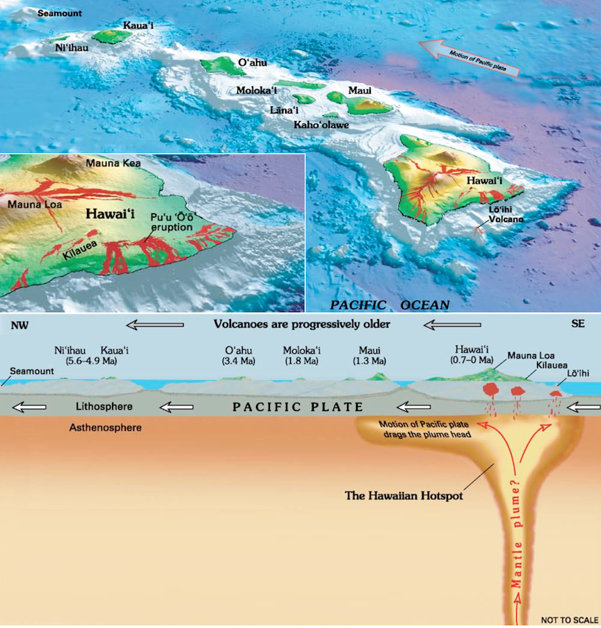
Geologic features forming away from plate boundaries are referred to as intraplate (within-plate) features. Intraplate chains of volcanic mountains such as the Hawaiian-Emperor seamount chain are formed by hotspots, where a plume of hot mantle rock rises up and melts the overlying lithosphere (Figure 13.41). The plume remains in the same location, but the plate does not. A chain of volcanoes forms because as the plate moves, a new part of the plate is exposed to the plume.
References
Whitmeyer, S., & Karlstrom, K. (2007). Tectonic model for the Proterozoic growth of North America. Geosphere, 3(4), 220-259. DOI: 10.1130/GES00055.
