4.1 Alfred Wegener’s Arguments for Plate Tectonics
Alfred Wegener (1880-1930; Figure 4.3) earned a PhD in astronomy at the University of Berlin in 1904, but had a keen interest in geophysics and meteorology, and focused on meteorology for much of his academic career. According to one of his friends from university, he wasn’t unusually talented in math and science, but what he did exceptionally well was make observations, think critically about their implications, and assemble his observations and ideas in a meaningful way. He also possessed an unwavering determination to get answers to his scientific questions (Runcorn, 1962, p. 322).
![Alfred Wegener during a 1912-1913 expedition to Greenland. [Source: Alfred Wegener Institute (Public domain)]](https://pressbooks.bccampus.ca/physicalgeologyh5p/wp-content/uploads/sites/1304/2018/08/Wegener_Expedition-1930_008-scaled.jpg)
In 1911 Wegener happened upon a scientific publication that described matching fossils in various parts of South America, Africa, India, Antarctica, and Australia. This was significant for two reasons: first, although similar organisms might evolve in similar but geographically separated environments (based on the fact that the kinds of organisms that can be successful in a location are the ones suited to that environment), the exact same organism cannot develop independently at different locations.
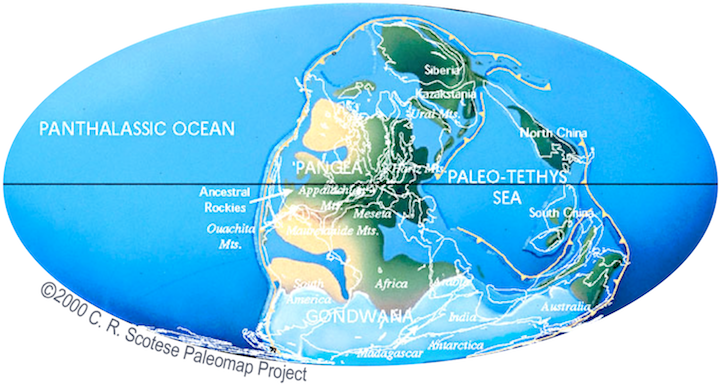
Second, the fossils were from organisms incapable of crossing oceans to get from one continent to another. Fossils distributed in this way include mammal ancestors that lived on land, an aquatic reptile that was restricted to freshwater or nearshore environments, and a fern that reproduced with heavy seed pods. The only way to explain the distribution was that the continents must have been joined in the past, permitting the animals to move from one land mass to the other (Figure 4.4). Wegener envisioned a supercontinent made up of all the present day continents, and named it Pangea (meaning “all land”). He described the motion of the continents re-configuring themselves as continental drift.

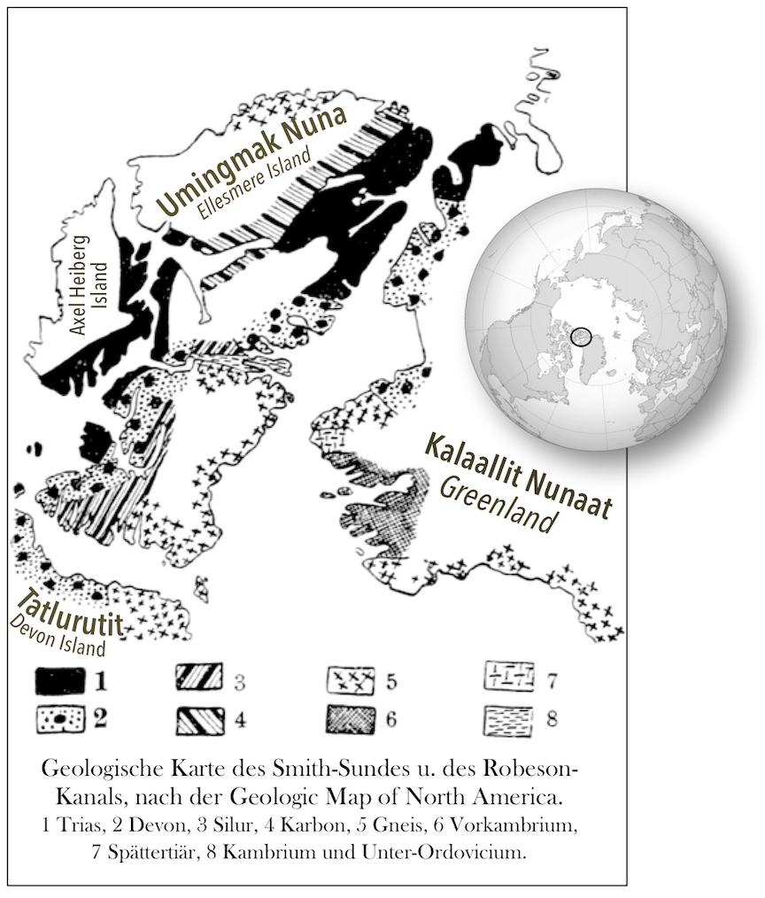
Wegener pursued his idea with determination, combing libraries, consulting with colleagues, and making observations in an effort to find evidence in support of it. He relied heavily on matching geological patterns across oceans, such as sedimentary strata in South America matching those in Africa, North American coalfields matching those in Europe, the mountains of Atlantic Canada matching those of northern Britain—both in structure and rock type—and comparisons of rocks in the Canadian Arctic with those of Greenland (Figure 4.5).
Wegener also called upon evidence for the Carboniferous and Permian (~300 Ma) Karoo Glaciation distributed throughout South America, Africa, India, Antarctica, and Australia (Figure 4.6). He argued that this distribution could only be explained if these continents were all connected as a single supercontinent at the time. He even used his own astronomical observations to demonstrate that the continents were moving relative to each other. He calculated that Greenland and Scandinavia were moving apart by 11 per year, although he admitted that the measurements weren’t accurate. (The separation rate is actually about 2.5 cm per year.)
Wegener first published his ideas in 1912 in a short book called Die Entstehung der Kontinente (The Origin of Continents), and then in 1915 in Die Entstehung der Kontinente und Ozeane (The Origin of Continents and Oceans). He revised this book several times up to 1929. It was translated into French, English, Spanish, and Russian in 1924.
The main criticism of Wegener’s idea was that he couldn’t explain how continents moved. Remember that as far as anyone was concerned, Earth’s crust was continuous, not broken into plates, and any mechanism Wegener could think of would have to fit that model.
Geologists at the time knew that continents were made of different rocks than the ocean crust, and that the material making up the continents was less dense. So, Wegener proposed that the continents plowed through the heavier ocean crust the way icebergs did through water. He suggested that continents were moved by the effect of Earth’s rotation pushing objects toward the equator, and by the lunar and solar tidal forces, which tend to push objects toward the west. But it was quickly shown that these forces were far too weak to move continents, and without any reasonable mechanism to make it work, Wegener’s theory was quickly dismissed by most geologists of the day.
Alfred Wegener died in Greenland in 1930 while carrying out studies related to glaciation and climate. At the time of his death, his ideas were tentatively accepted by a small minority of geologists, and firmly rejected by most. But within a few decades that was all to change.
Resources
On The Shoulders of Giants: Alfred Wegener
References
Runcorn, S. K. (Ed.). (1962). Continental Drift. Academic Press.
Wegener, A. (1920). Die Entstehung der Kontinente und Ozeane. Braunschweig, Germany: Friedr. Vieweg & Sohn. Full text at Project Gutenberg
