14.2 Channel Development and Drainage Basins
How Do Stream Channels Form in the First Place?
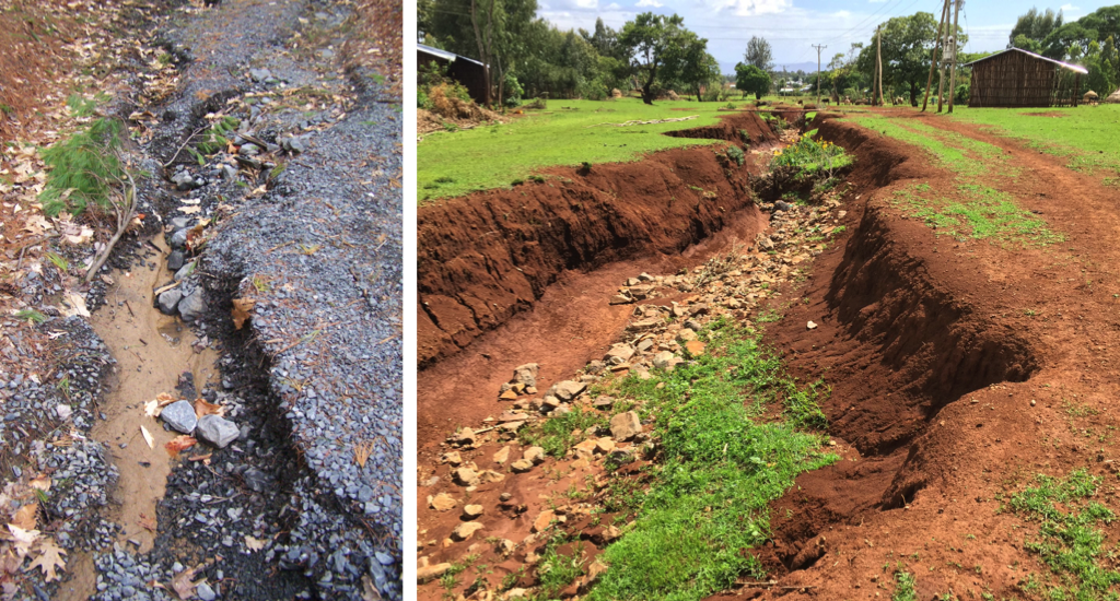
Stream channels develop because natural surfaces are not uniform. Overland flow will be directed downhill or into lower spots, and begin to erode the surface. Once a small channel forms, more water is directed into it, causing the channel to become larger. Figure 14.6 (left) shows a small channel that developed by overland flow after a few days of heavy rain. Notice near the bottom of the photo where the banks of the channel have collapsed, widening the channel. Also notice that a smaller channel formed in the upper left, and funneled more water to the main channel. Smaller streams feeding a large one are called tributaries. Figure 14.6 (right) shows what happens when this process continues in soft sediments. This channel is now wide enough to affect how people can move around their community.
Downcutting and Headward Erosion
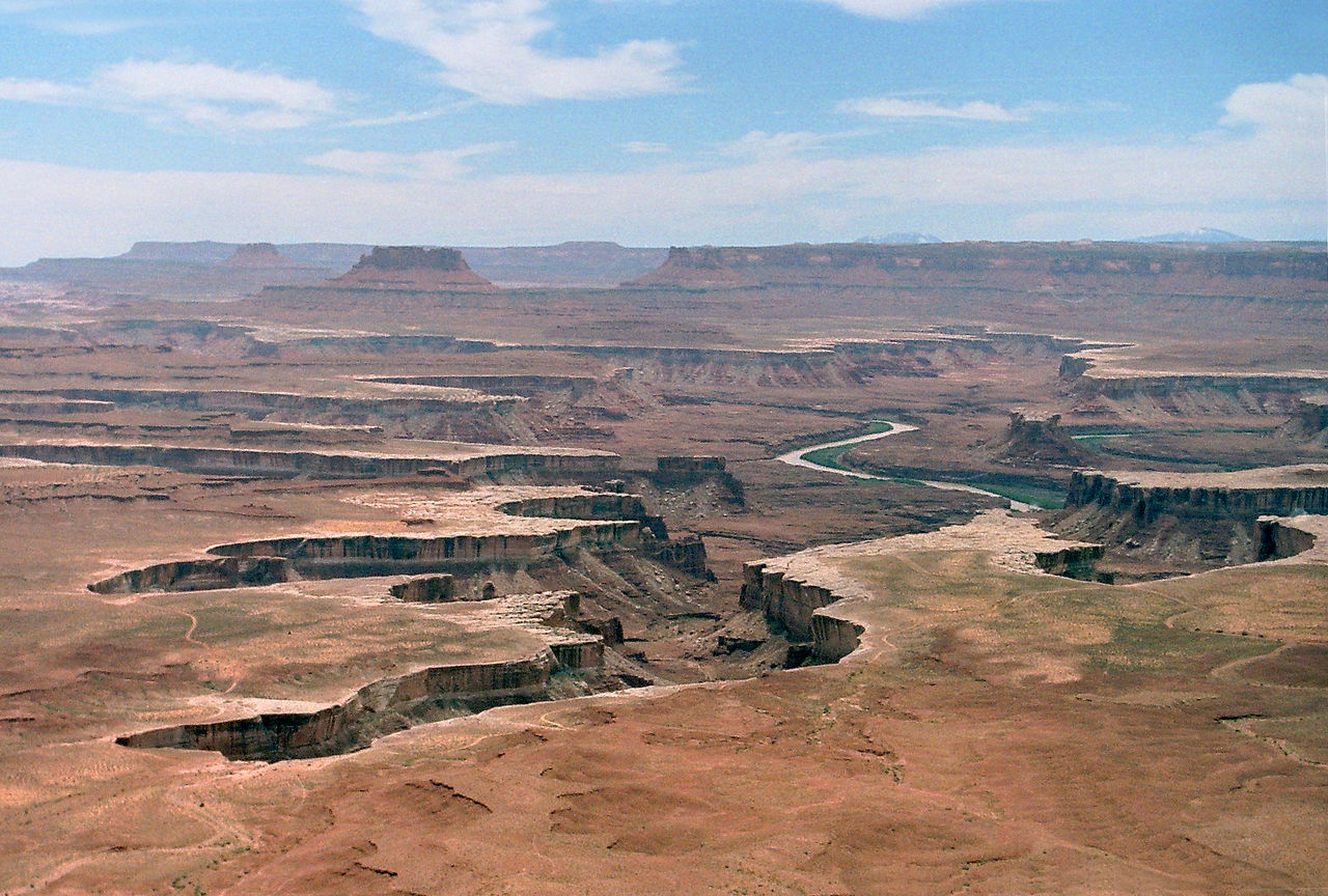
The process of a stream eroding downward into bedrock is called downcutting. Although streams cause erosion in the downstream direction, stream channels lengthen in the upstream direction through headward erosion. Figure 14.7 shows a plateau in Canyonlands National Park being cut into by headward erosion. Rapid erosion occurs where water falls over the edge of the plateau and into the streams below, causing the channel to be cut deeper and deeper into the plateau. (Click here to explore Canyonlands in Google Earth. See if you can find some examples of headward erosion.)
Stream Gradients and Graded Streams
After a time, all stream channels develop the same type of profile along their length: the closer to the source of the stream (and thus, the higher the elevation), the steeper the slope. For streams, slope is expressed as a gradient rather than an angle. The gradient of a stream indicates the change in height over a given distance. For example, a gradient of 20 m/km means that for every 1 km of distance, the elevation of the stream will drop by 20 m. A steep gradient means a large change in elevation with horizontal distance, and a shallow gradient means a slow change in elevation with horizontal distance.
Figure 14.8 shows the profiles of four streams from a study area in the Ozark Mountains. Note that the vertical scale is exaggerated (stretched) relative to the horizontal scale. If it weren’t the stream profiles would look like flat lines. Fourche Creek is an excellent example of the characteristic stream profile, and so is referred to as a graded stream. Bull Creek and Cadron Creek also display characteristics of a graded stream, except their profiles are broken up by knick points (marked by triangles), where the steep-to-gentle slope progression starts over again. Knick points reflect locations where the surface is much harder to erode. Waterfalls may be present at knick points.
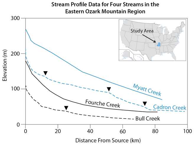
Myatt Creek has some elements of a graded stream, but overall the profile is not well developed. All streams develop a graded profile over time, so the absence of a graded profile led researchers to conclude that the area had undergone tectonic uplift approximately 5 million years ago (McKeown et al., 1988).
The graded profile of a stream reflects a balance between the rate of water and sediment flowing in and out of a channel, and uplift or subsidence in a region. The profile will change until the grade of the stream brings these things into balance by adjusting the flow rates. Once that happens, erosion will continue, but the shape of the stream profile won’t change. This is why the lack of a curve in the Myatt Creek profile tells us that Myatt Creek hasn’t had time to adjust its profile since uplift occurred. Given time, Myatt Creek will also establish a graded profile.
Base Level
A stream’s base level is the lowest point to which it can erode, and depends on the energy available from gravity. The ocean is the ultimate base level, but there can be local base levels such as lakes, or rock layers that are resistant to erosion. Knick points represent local base levels.
When the base level changes, the stream responds. If base level drops, such as with a drop in sea level, or if a region experiences uplift (this is the same as a drop in base level from the stream’s perspective because the ocean is lower than the mouth of the stream), then downcutting will occur as the stream carves its way into the surface beneath it, until the stream has recovered a graded profile. This is the process occurring in Canyonlands National Park. On the other hand, if the base level rises—such as with an increase in sea level, or tectonic subsidence—then the river will dump sediment until it builds its channel back up to base level.
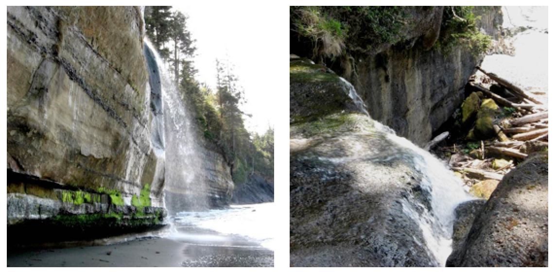
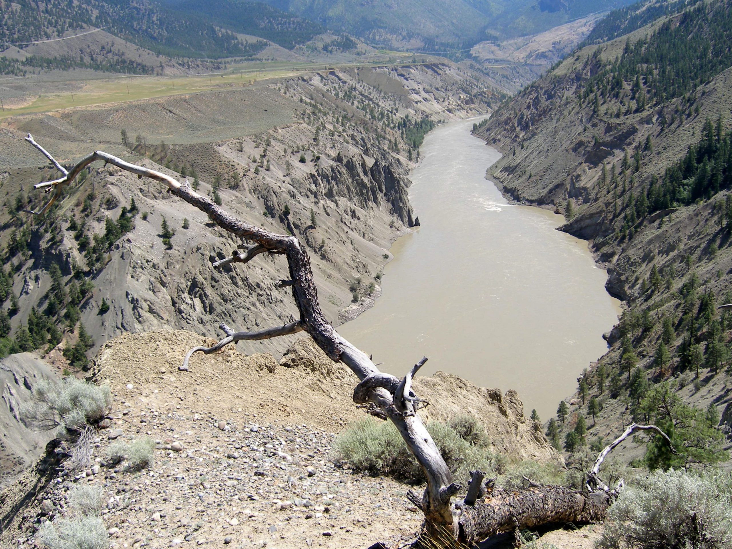
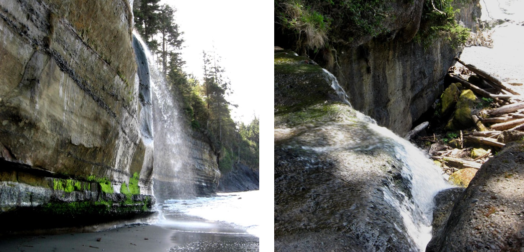
An example of a change in base level can be seen along the Juan de Fuca Trail on southwestern Vancouver Island. Many of the small streams along this part of the coast flow into the ocean as waterfalls (Figure 14.9). The land in this area has risen by about 5 m in the past few thousand years, probably in response to glaciers melting. (Click here for a refresher on glacial rebound). The streams that used to flow directly into the ocean now have a lot of downcutting to do before they will be graded streams again.
A change in base level is also evident where terraces are present. Terraces are flat, eleveated terrain adjacent to streams that form when a stream channel cuts into its flood plain (e.g., as along the Fraser River on the left side of Figure 14.10). If downcutting happens more than once, and too frequently for a stream to erode all of its previous flood plain, multiple terraces may develop, forming steps.
Base Levels and Graded Streams Are Part of a Bigger Picture
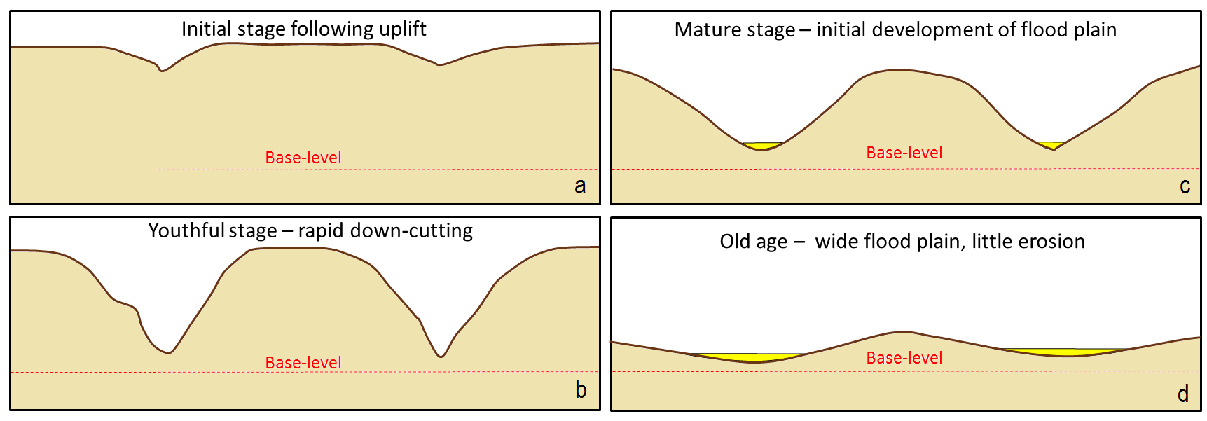
In the late 19th century, American geologist William Davis proposed that streams and the surrounding terrain develop in a cycle of erosion (Figure 14.11). Following tectonic uplift , the stream patterns are immature. Streams erode quickly, developing deep V-shaped valleys that tend to follow relatively straight paths. Gradients are high, and profiles are ungraded. Rapids and waterfalls are common. As the landscape matures, the streams erode wider valleys and deposited thick sediment layers. Even after maturity, gradients are slowly reduced and grading increases. In old age, streams are surrounded by rolling hills, and they occupy wide sediment-filled valleys. Winding patterns are common, and erosion now is focused towards the channel walls, with little downcutting. You will encounter this progression once again later in this chapter.
![Figure 13.13 A depiction of the Davis cycle of erosion: a: initial stage, b: youthful stage, c: mature stage, and d: old age. [SE]](https://pressbooks.bccampus.ca/physicalgeologyh5p/wp-content/uploads/sites/1304/2021/03/Davis-cycle-of-erosion.png)
Davis’s work was done long before the idea of plate tectonics, and he was also not familiar with the impacts of glacial erosion on streams and their environments. While some parts of his idea are out of date, it is still a useful way to understand streams and their evolution. Plate tectonic activity and other processes such as isostatic rebound after glaciation results in uplift that alters stream gradients, so streams are constantly adjusting due to these changing conditions. It would be relatively rare to find a stream that is able to mature through all of these stages without interruption.
Drainage Basins
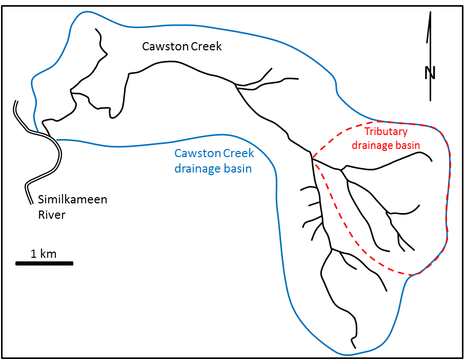
A stream’s drainage basin or watershed is the area where the water that feeds the stream comes from. The drainage basin for Cawston Creek is outlined in blue in Figure 14.12. Water draining from anywhere within the blue-outlined area will eventually find its way into Cawston Creek.
![Figure 13.4 Cawston Creek near Keremeos, B.C. The blue line shows the extent of the drainage basin. The dashed red line is the drainage basin of one of its tributaries. [SE]](https://pressbooks.bccampus.ca/physicalgeologyh5p/wp-content/uploads/sites/1304/2017/11/Cawston-Creek-e1438915203759.png)
The water supply for the Vancouver, BC metropolitan area comes from three large drainage basins on the north shore of Burrard Inlet (Figure 14.13). Some of the basins are right next to each other, but they are separated by a ridge of land called a drainage divide. Rain falling on the Capilano basin side, for example, cannot flow into the Seymour drainage basin, because of the drainage basin divide. However, a drop of rain falling exactly on the boundary between the Capilano and Seymour drainage basins could flow into either basin.

Drainage Patterns
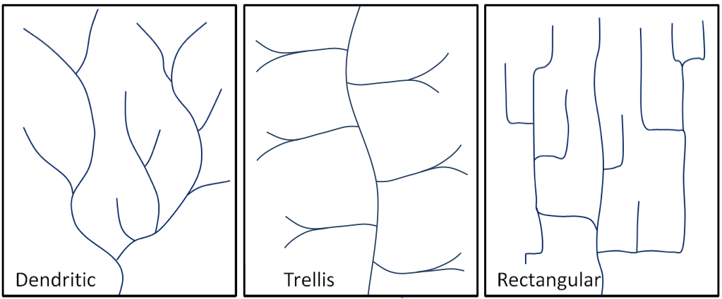
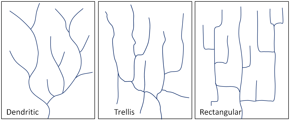
The pattern of tributaries within a drainage basin depends largely upon the type of underlying rock, and on structures within that rock (e.g., folds, fractures, and faults). Dendritic patterns (Figure 14.14, left) are by far the most common, and develop in areas where the rock (or unconsolidated material) beneath the stream doesn’t have structures that control the stream flow patterns. The materials can be eroded by the stream equally easily in all directions. Most areas of British Columbia have dendritic patterns, as do most areas of the prairies and the Canadian Shield.
Trellis drainage patterns (Figure 14.14, middle) typically develop where sedimentary rocks have been folded or tilted, and then eroded to varying degrees depending on their resistance to erosion. Tilted and eroded layers form ridges, and the spaces in between form valleys and tend to fill with sediment. The Rocky Mountains of BC and AB have some fine examples of trellis drainage.
Rectangular patterns develop in areas with generally flat terrain, and where a system of bedding planes, fractures, or faults form a rectangular network. Rectangular drainage patterns are present in Canada’s north.
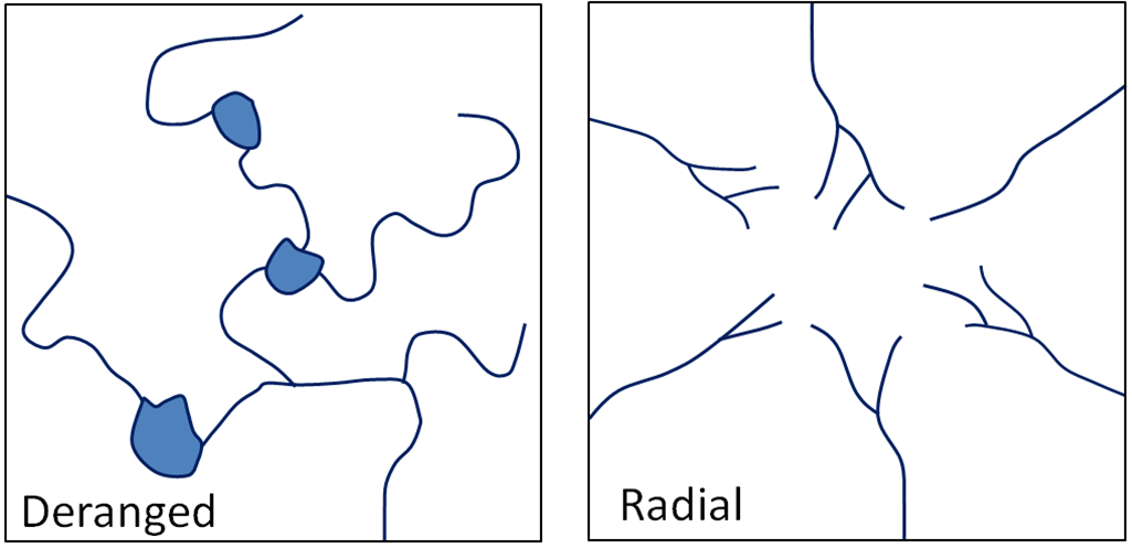
In many parts of Canada, especially relatively flat areas with thick glacial sediments, and throughout much of Canadian Shield in eastern and central Canada, drainage patterns are chaotic , also known as deranged (Figure 14.15, left). Lakes and wetlands are common in this type of environment.
Radial drainage (Figure 14.15, right) is a pattern that forms around isolated mountains (such as volcanoes) or hills. The individual streams that radiate out from the hill typically have dendritic drainage patterns.
![Figure 13.8 Left: a typical deranged pattern; right: a typical radial drainage pattern developed around a mountain or hill. [SE]](https://pressbooks.bccampus.ca/physicalgeologyh5p/wp-content/uploads/sites/1304/2021/03/deranged-and-radial.png)
References
McKeown, F. A., Jones-Cecil, M., Askew, B. L., & McGrath, M. B. (1988). Analysis of stream-profile data and inferred tectonic activity, Eastern Ozark Mountains Region (U. S. Geological Survey Bulletin No.1807). Washington, DC: U. S. Government Printing Office.
