Part 3 – Data Export
Chapter 3.2 – Export Othomosaic
Overview
This chapter describes the steps to export the Orthomosaic into a variety of external data formats.
Export Orthomosaic
One of the main applications for orthomosaics is to serve as a spatially accurate underlay in a mult-layer geographic information system (GIS). MetaShape allows export in the following data formats;
Exporting an orthomosaic in GeoTIFF format allows for further analysis and processing external software such as PCI Geomatica, ESRI ArcMap or QGIS. This is especially important when performing mult-spectral analysis using multi-band data.
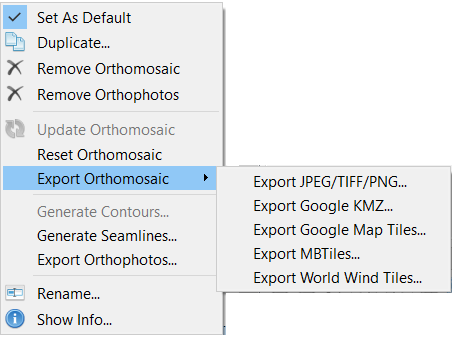
To export the Orthomosaic, right-click on it in the Workspace, select Export Orthomosaic… and choose the export file format (e.g. Export JPEG/TIFF/PNG…).
The suggested output parameters are shown in Fig. 25, but they may vary depending on the specific software and user requirements.
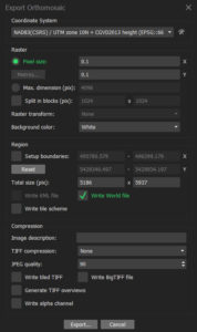
Click Export, navigate to where you want to save the orthomosaic, enter a name and click Save.
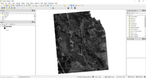
The orthomosaic (Blue band), is shown loaded in QGIS in the correct projection system below (Fig. 26).
Summary
Following the steps in Chapters 1.2 through to 3.2 allows for the set up, processing and export of multi-spectral images using Agisoft MetaShape Pro. One of the main elements to pay attention to when processing multi-spectral imagery, is the use of ground control points (GCPs). GCPs area a key element because they ensure that all five (blue, green, red, NIR and red edge) exported orthomosaics will correctly line up with each in order to ensure that the same pixels are being analyzed from each band. This is why it of great importance to make sure that the absolute alignment errors are less than one ground sampling distance.
