Chapter 7. Geological Structures Part A: Relative Age and Orientation of Geologic Layers
Lab 8 Activity
Note: This assignment refers to “units.” A unit in this context is a distinct rock layer or occurrence. For example, two sandstone beds that are nearly identical in appearance, but are different ages, are each a distinctive rock layer. If there is only one sandstone bed showing up in many different places on the map, this is still only one distinct rock layer. We use the term unit because not all units are actually beds or layers. A blob-shaped igneous intrusion is neither of those things, but still counts as a unit.
Overview
In this lab you will practice applying the concepts of strike and dip, and construct and interpret structural cross-sections.
A. Strike and Dip
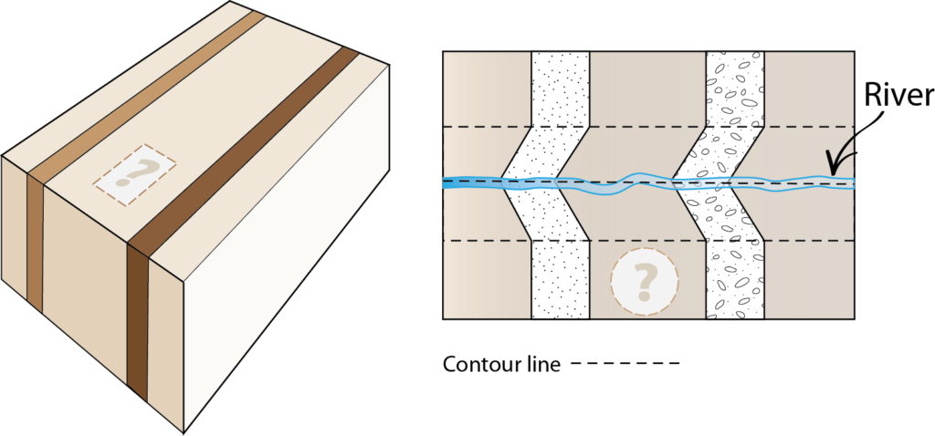
A.1. Which map symbols should replace the question marks in the figures below?
A.2. Using Google Earth or Google Maps, search for the following area in Pakistan: 27°50’35.00″N 67°10’03.70″E. (Click here to see the location in Google Earth Web. You may need to be patient for a moment if loading takes a while.) If you are using Google Maps through your browser, make sure satellite data is turned on.
Zoom out to an eye altitude of approximately 7.9 km (about 26,000 feet; the scale bar in Google Maps will be 500 m long at this height). The layers in these folded rocks can be seen from this altitude. Note: Double check that the position of the north arrow is pointed to the top of your screen before you answer the questions.
a) What evidence do you see that indicates the direction the rocks are dipping? Sketch a simple map to illustrate the key relationships. Hint: If you zoom in a little bit closer on the gully that runs through the strata near the position marker you can see an example of the rule of Vs in the darker-coloured strata.
b) Which way are the beds dipping: NW, SW, NE, or SE?
B. Drawing Structural Cross-Sections
The three geological maps on the next few pages will give you practice with constructing geological cross-sections.
Map 1: Murky Mists Mountain
Map 1 (Figure 7.15) is a geologic map showing a series of sedimentary beds, all of which have the same strike and dip as given by symbols on the map. Contour lines are shown as dashed lines and lines of contact between formations are shown as solid lines. Note that the symbol key is not in order according to age.
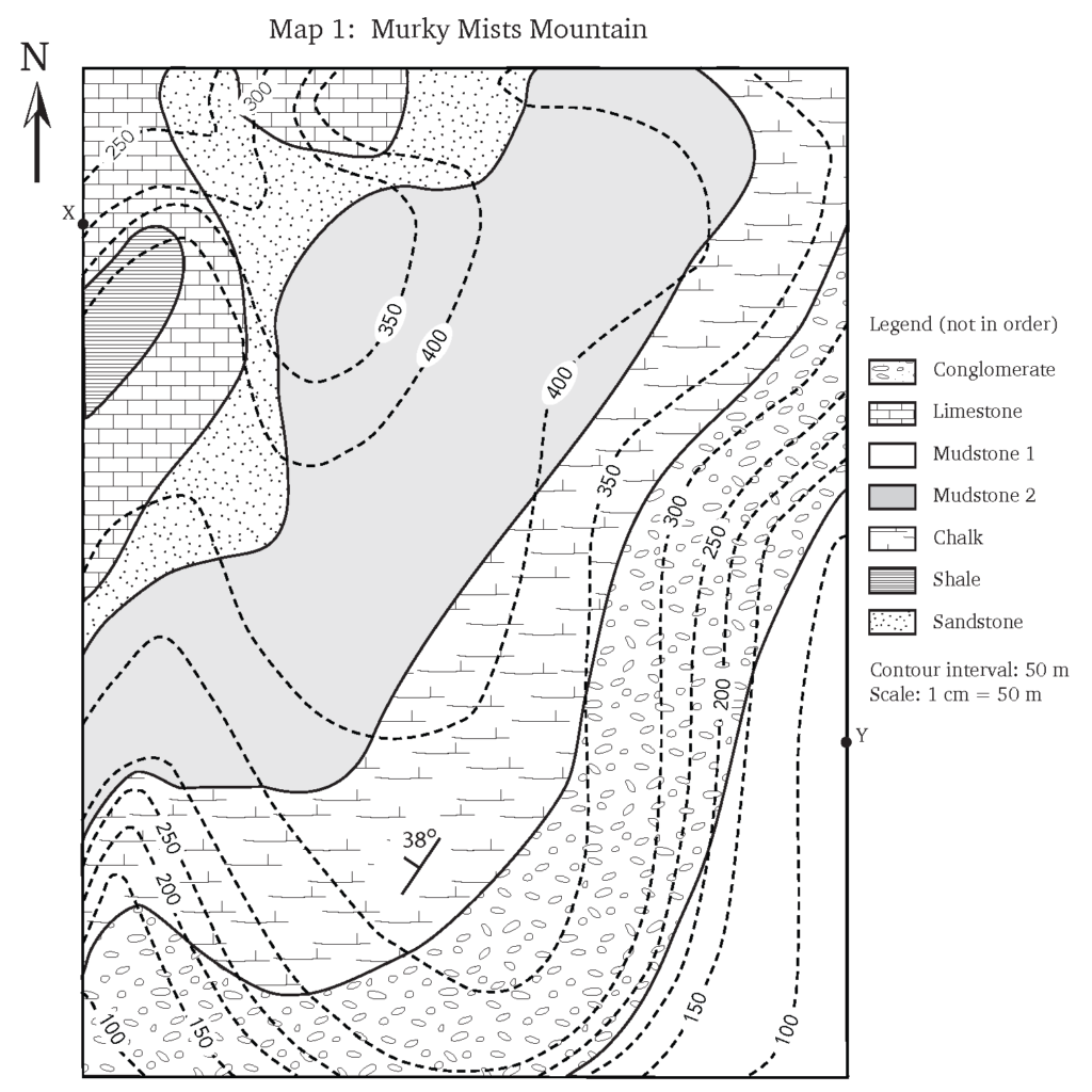
a) Examine the map of the Murky Mists Mountain. Refer to the map legend. What kinds of rocks are found in this map area: sedimentary, igneous, and/or metamorphic? How many units can you see?
b) Note the strike and dip symbol on the map. Assume that the beds all have identical strike and dip. Which direction are the units striking and dipping?
c) Examine the contour lines on the map (dashed lines). Where are the highest points on the map? Where are the lowest points on the map?
d) Note the scale of the map. What is the horizontal distance in metres between point X and point Y? If you walk from X to Y, in what direction are you walking?
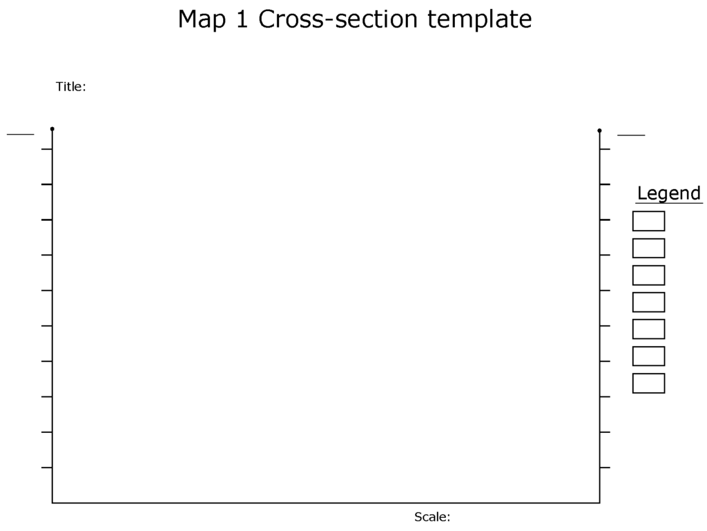
e) Prepare a cross-section through the map from position X to Y (X-Y) using the cross-section template provided (Figure 7.16). Do not forget to indicate the X and Y positions on your cross-section. Also, add a scale bar and the ratio scale, legend, and a title. To remember to add these critical components of a cross-section, remember the acronym LOTS (legend, orientation, title, scale). Note: ensure your vertical scale and horizontal scale are the same, and order the rock layers in your legend with the oldest at the bottom and the youngest at the top.
f) Using the cross-section you have prepared and the distances between the upper and lower contacts for each unit, calculate the thickness of the limestone, sandstone, mudstone 2, chalk, and conglomerate beds. Mark the locations where you measured your thicknesses with a line on your cross-section. Note: The thickness is the shortest distance between the upper and lower contact of a bed, along a line that runs perpendicular to both contacts.
g) Why can’t you measure the thickness of the shale or mudstone 1 beds?
Map 2: Delightful Dells Geological Paradise
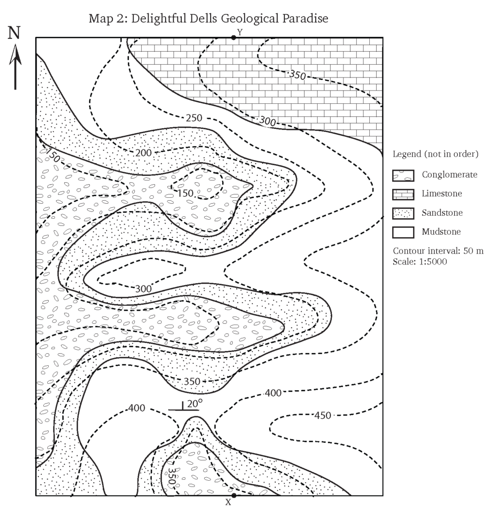
a) What kinds of rocks are found in this map area (sedimentary, igneous, and/or metamorphic)? How many units can you see?
b) Draw a geological cross-section between the points X and Y indicated on Map 2. Note: You will have to prepare a cross-section from scratch for this exercise, but you can use the format from the Map 1 cross-section as a guide. If you are not sure where to start, use the questions from Map 1 to guide you through the process of exploring Map 2 and preparing your cross-section. Do not forget to incorporate the features described in the LOTS acronym. Note: This is a more challenging cross-section—you will probably have to make several changes to get it right. Make sure you have an eraser with you!
c) What are the thicknesses of the mudstone and sandstone beds? Indicate the locations where you performed these measurements on your cross-section.
d) Why can’t you measure the thickness of the conglomerate or the limestone?
e) In point form, describe the geological history of the map area.
Map 3: Four-River Ridge
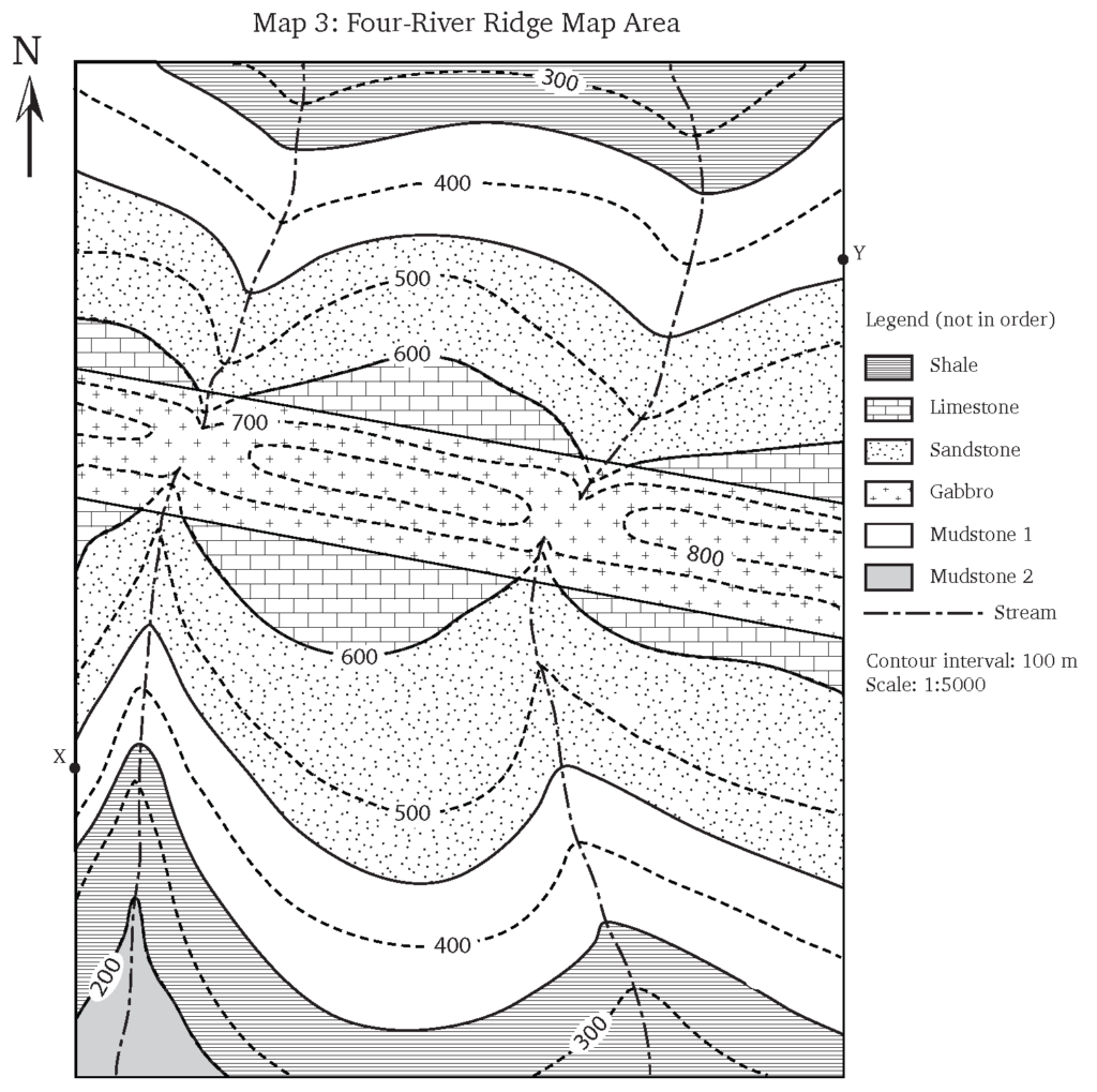
a) What kinds of rocks are found in this map area (sedimentary, igneous, and/or metamorphic)? How many units can you see?
b) Carefully study the relationship between the contour lines and the contact between the limestone and sandstone. What does this tell you about the orientation of these beds?
c) What is the strike and dip of the sedimentary units in the map area?
Strike: ____________ Dip: ____________
d) What is the strike and dip of the gabbro dike?
Strike: ____________ Dip: ____________
e) Draw a cross-section through the map area along the line between points X and Y. Don’t forget to incorporate LOTS!
f) In point form, describe the geological history of the map area.
Attributions
Adapted from:
McBeth, J., Panchuk, K., Prokopiuk, T., Hauber, L., & Lacey, S. (2020). Introductory Physical Geology Laboratory Manual, 1st Canadian Ed., Exercises on Geological Structures Part 1: Strike, Dip, and Structural Cross-Sections by K. Panchuk, J. McBeth, K. Panchuk, & L. R. Hauber. CC BY-SA 4.0
Deline, B., Harris. R. & Tefend, K. (2015) Laboratory Manual for Introductory Geology, 1st Edition, Chapter 12. “Crustal Deformation” by R. Harris & B. Deline. CC BY-SA 4.0
