Chapter 7. Geological Structures Part A: Relative Age and Orientation of Geologic Layers
Introduction
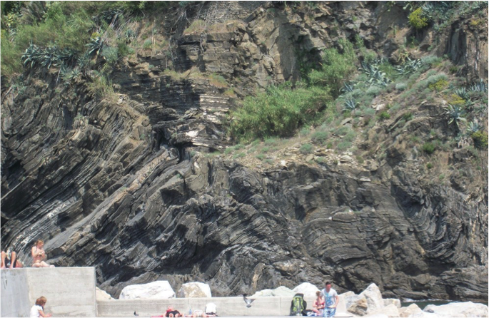
Earth is an active planet shaped by dynamic forces. The forces generated by plate tectonics and other geological processes can build mountains, and crumple and fold rocks. As rocks respond to these forces, they undergo deformation, changing the shape and/or volume of the rocks. The resulting features are geologic structures. Deformation can produce dramatic and beautiful scenery, such as the folded rocks in Figure 7.1 that started out as flat horizontal layers. Structural geology is the subfield of geology in which scientists study the relationships between geological structures (such as folds and faults) and the processes (such as plate tectonics) that have shaped Earth’s crust through time.
The topic of structural geology is broken into two chapters here. Chapter 7 is an overview of the methods geologists use to describe geological structures, including strike and dip measurements, representations of geological structures on maps, how to construct geological cross-sections and measure the thicknesses of geologic units. In Chapter 8 you will learn about how to interpret and draw more complex geological structures (folds, faults, and unconformities) on geological maps and cross-sections.
Why Study Structures and Deformation Within the Crust?
These studies can provide us with a record of the geologic history in a region, and also give us clues to the broader geological processes happening globally through time. Such information can be critical when searching for valuable mineral resources. The correct interpretation of features created during deformation helps geologists find oil and valuable metal ores. It is also essential for engineers to understand the behavior of deformed rocks to create and maintain safely engineered structures, such as in open and underground mines, and for roads.
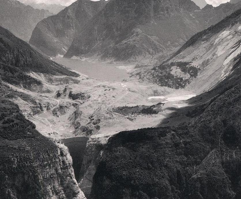
When engineers do not adequately consider geology in their planning, disaster can strike. An example of this is the disaster that occurred at the Vajont Dam, Monte Toc, Italy in the early 1960s. The location—a steep and narrow valley with undercut riverbanks at the base—was a poor choice for a dam. Aside from slope instability because of the topography, the area surrounding the dam was prone to large landslides because of cavities in the limestone canyon walls that could fill with water. Furthermore, interbedded claystones (alternating and cross cutting beds) generated zones of structural weakness in the rocks.
Thorough geological tests were not performed prior to construction. During the filling of the dam there were warning signs: rock shifted and fractured, and surface geological deposits began to move more rapidly downhill. Nevertheless, the warning signs were disregarded. In 1963, a massive landslide (visible in Figure 7.2 between the dam and the lake) sloshed water over the top of the dam, flooding downstream villages and causing almost 2,000 fatalities.
Learning Outcomes
After completing this chapter, you should be able to:
- Interpret a geologic map
- Apply the concepts of strike and dip to analyze a geologic map
- Use block diagrams to illustrate geologic features
- Create a geologic cross-section from a geologic map
Key Terms
- Apparent thickness
- Azimuth convention
- Block diagram/ block model
- Contact
- Dip
- Geological (structural) cross-section
- Geological map
- Principle of original horizontality
- Principle of superposition
- Principle of cross-cutting relationships
- Quadrant convention
- Relative age
- Strike
- True thickness
- Symbols:
![]()
Attributions
Adapted from:
McBeth, J., Panchuk, K., Prokopiuk, T., Hauber, L., & Lacey, S. (2020). Introductory Physical Geology Laboratory Manual, 1st Canadian Ed., Chapter 8. Geological Structures by J. McBeth, K. Panchuk, L. R. Hauber, T. C. Prokopiuk, & S. W. Lacey. CC BY-SA 4.0
Deline, B., Harris. R. & Tefend, K. (2015) Laboratory Manual for Introductory Geology, 1st Edition, Chapter 12. “Crustal Deformation” by R. Harris & B. Deline. CC BY-SA 4.0
