Appendix 2: Köppen Climate Classification System
INTRODUCTION
Climate can be defined as the long-term trends observed in the state of the weather (temperature, precipitation, humidity, etc.) on a time scale of years to decades. Understanding these trends allows us to make predictions about what the weather may be like in the immediate future. Several systems have been developed for classifying the climates of locations found on our planet. The classification of data is a common process in all sciences. From classification, we can determine similarities and dissimilarities in the data. The classification process also helps us to identify patterns in data that are usually controlled by other factors. For the climate of locations found on the Earth, we will discover that locations with comparable climates are often influenced by similar climatic factors despite being geographically separated by great distances.
The Köppen Climate Classification system is an empirical system that uses readily available precipitation and temperature data collected at weather stations. For the classification process, the data must be arranged as monthly totals of precipitation, monthly temperatures, annual total of precipitation, and annual temperature. Monthly temperature is calculated by first determining the daily means for all days in the month by finding the average of daily maximum and daily minimum temperatures. All the daily means are then added together and then divided by a value equal to the number of days in that particular month. Finally, monthly and annual temperature and precipitation data should be averaged over a number of consecutive years. This averaging evens out the natural variation normally found in climate data.
TROPICAL MOIST CLIMATES – “A” CLIMATES
Tropical moist climates extend northward and southward from the equator to about 15 to 25° of latitude. In these climates, all months have average temperatures greater than 18°Celsius (64°Fahrenheit). Annual precipitation is often greater than 1500 mm (59 in). Three minor Köppen climate types exist in the A group. These three categories of tropical moist climate are distinguished by the seasonal distribution of rainfall.
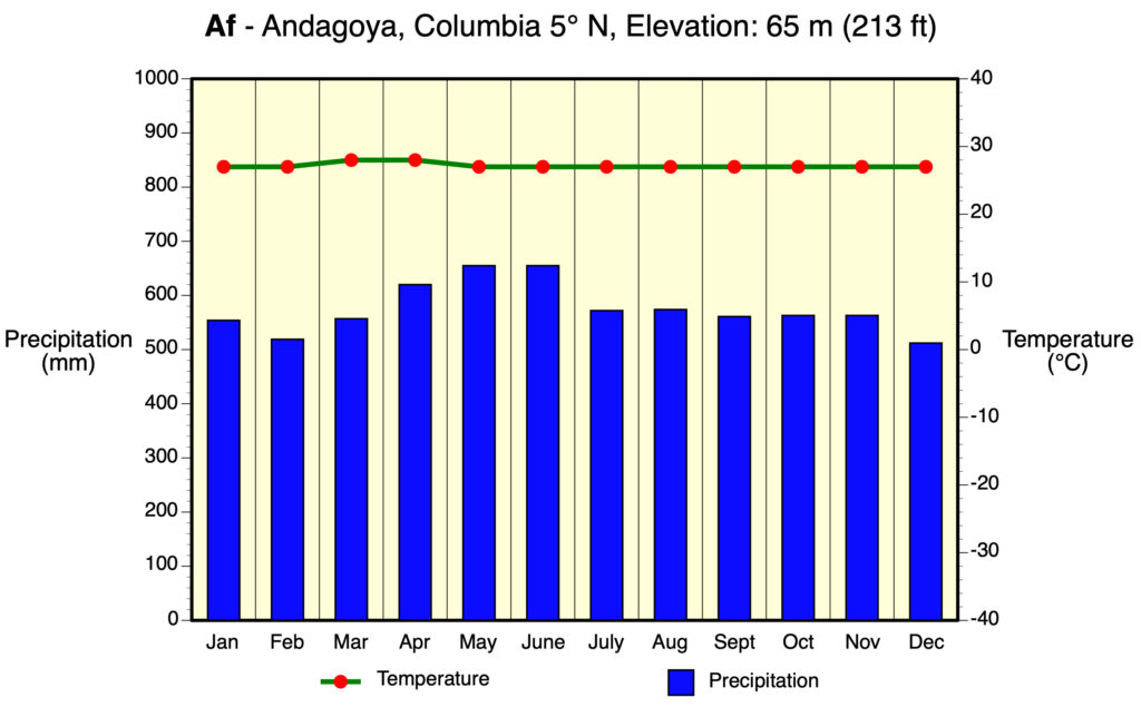
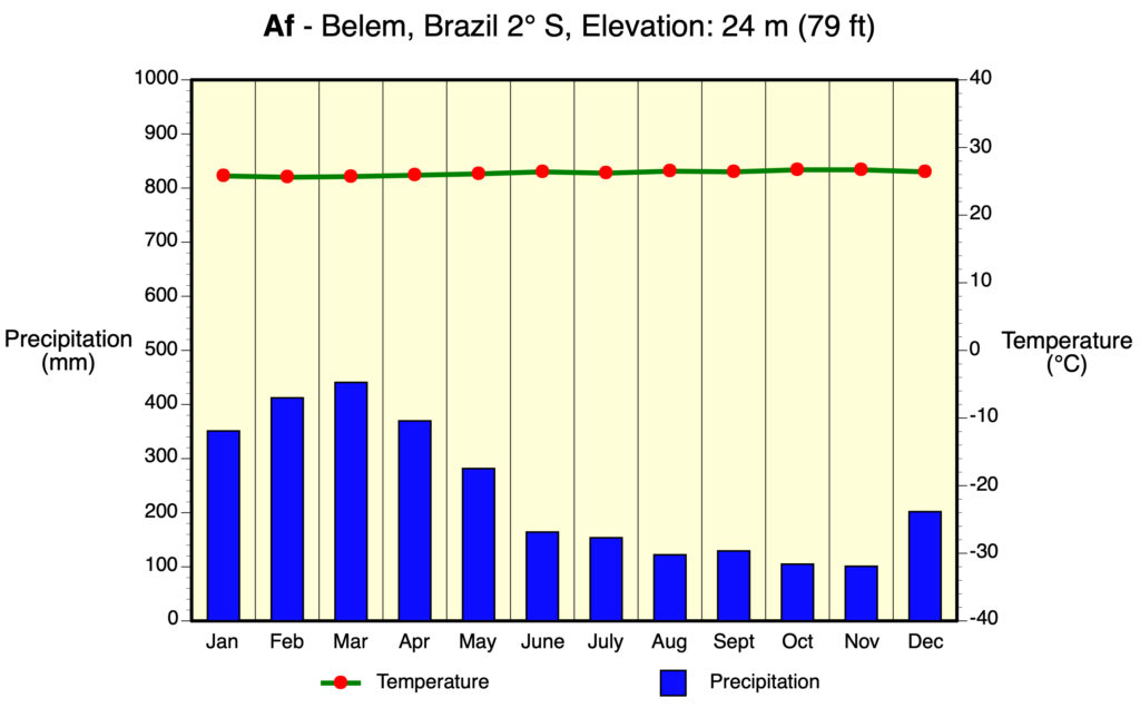
Af – Tropical Wet
Af or tropical wet is a tropical climate where precipitation occurs all year long. Monthly temperature variations in this climate are usually less than 3°C (37°F). Because of intense surface heating and high humidity, cumulus and cumulonimbus clouds (thunderstorms) form early in the afternoons almost every day. Daily highs are about 32°C (90°F). Radiative cooling during the evening is limited because of cloud cover and high humidity. Nighttime daily temperatures average about 22°C (72°F).
Locations: Amazon River Basin (South America), Congo River Basin (Africa), eastern coast of Central America, eastern coast of Brazil, the Philippines, the coast of Madagascar, eastern India, southern Bangladesh, Malaysia, and Indonesia.
Controlling Weather Factors: High year-round input of high quantities of solar radiation (insolation). High and constant monthly precipitation because of the presence of thunderstorm activity associated with the Intertropical Convergence Zone.
Climate Characteristics: Constant high temperatures throughout the year. Average monthly temperatures are very similar – yearly range is about 2 to 3°C (36 to 37°F). Monthly precipitation is evenly distributed and annual amounts are usually greater than 1500 mm (59 in). These climates also have frequent cumulus cloud development with some of these clouds becoming air mass thunderstorms. Humidity tends to be high.
Examples:
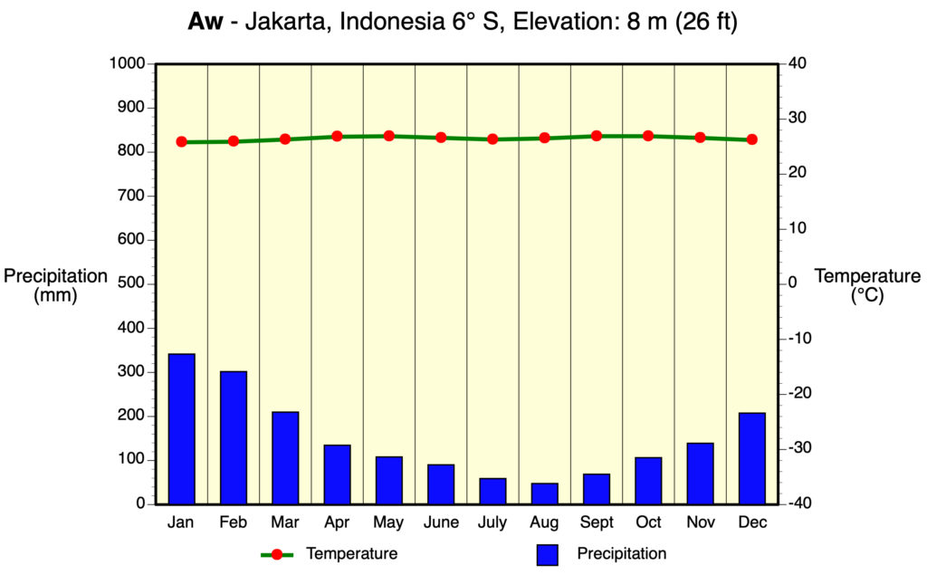
Aw – Tropical Wet and Dry
The tropical wet and dry or savanna (Aw) has an extended dry season during winter. Precipitation during the wet season is usually less than 1000 millimeters (39 in), and only during the summer season. Average monthly temperatures for all months are greater than 18°C (64°F). More than two months have less than 60 mm (2.4 in) of precipitation. There is a distinct dry season during the low-sun period (winter) and a distinct wet season during the high-sun period (summer). These climates are generally poleward of Af climate areas.
Locations: Northern and eastern India, central Myanmar, the Indo-Chinese Peninsula, northern Australia, region around the Congo River basin, south-central Africa, western Central America, parts of Venezuela, and parts of Brazil, the southern tip of Florida, and the Caribbean Islands.
Controlling Weather Factors: Alternating wet and dry seasons caused by the seasonal presence of the Intertropical Convergence Zone during the high-sun season and the Subtropical High Pressure Zone during the low-sun season.
Climate Characteristics: Monthly precipitation data shows distinct high-sun wet and low-sun dry seasons. Annual rainfall averages between 750 and 1800 mm (30 and 71 in). This climate has the highest monthly temperature ranges of the A climate category.
Example:
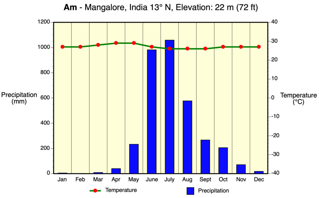
Am – Tropical Monsoon
Am is a tropical monsoon climate. Annual rainfall is equal to or greater than Af, but most of the precipitation falls in the 7 to 9 hottest months. Have a very pronounced wet season. During the dry season, very little rainfall occurs. Average monthly temperatures for all months is greater than 18°C (64°F). Have one or more months with less than 60 mm (2.4 in) of precipitation.
Locations: Coastal areas of southwestern India, Sri Lanka, Bangladesh, Myanmar, southwestern Africa, Guyana, Surinam, French Guiana, and parts of northeast and southeast Brazil.
Controlling Weather Factors: Monsoonal summer onshore and winter offshore air mass movement related to seasonally shifting Intertropical Convergence Zone and changing surface atmospheric pressure conditions over the landmasses and ocean areas involved.
Climate Characteristics: Climate of this category is transitional between Af and Aw. Heaviest rainfall records in the world occur in this climate type (Cherripunji, India – 12,000 mm (472 in)). Heavy rainfall is associated with the high-sun (summer) season. Precipitation can be greatly enhanced by orographic uplift. Yearly precipitation totals range from between 1500 to 4000 mm. Dry season is associated with the low-sun (winter) period. Annual temperature range of monthly averages is about 2 to 6°C (36 to 43°F). Highest monthly temperature often occurs just before the start of the rainy season.
Example:
DRY CLIMATES – “B” CLIMATES
The most obvious feature of this climate is that potential evapotranspiration exceeds precipitation. These climates extend from 20 – 35° North and South of the equator and in large continental regions of the mid-latitudes often surrounded by mountains. Four minor types of this climate occur:
BW – Dry Arid (Desert)
BW is a true desert climate. It covers 12% of the Earth’s land surface and is dominated by xerophytic vegetation. The additional letters h and k are used generally to distinguish whether the dry arid climate is found in the subtropics or in the mid-latitudes, respectively.
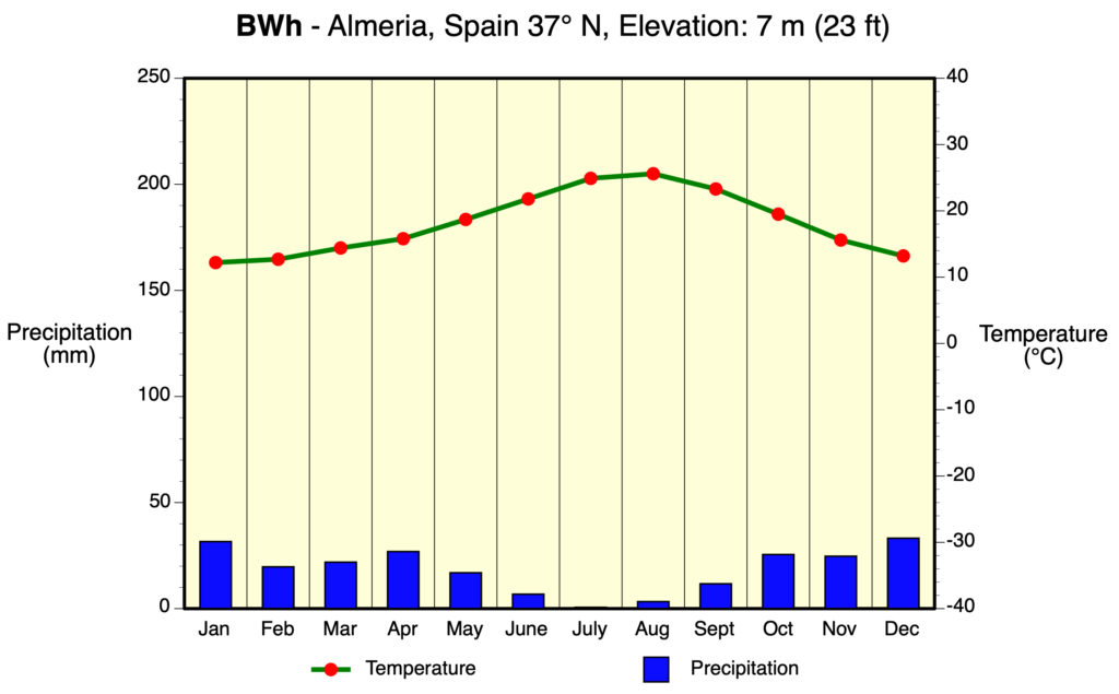
BWh – Dry Arid Low Latitudes
BWh is a dry arid climate found in low latitude deserts. The most distinguishing aspect of this climate is that precipitation is less than 50% of potential evapotranspiration. Annual average temperature is over 18°C (64°F). Daily minimum temperatures infrequently go below 0°C (32°F) during the winter season.
Locations: Northern Mexico, southwestern United States, northern Africa Saudi Arabia, Iran, western India, central and western Australia, and southern and western Africa.
BWk – Dry Arid Mid-Latitudes
BWk is a dry arid climate found in middle latitude deserts. Like BWh, precipitation is less than half of potential evapotranspiration. Annual average temperature is below 18°C (64°F). Daily minimum temperatures can frequently go below 0°C (32°F) during the winter season.
Locations: From the Caspian Sea eastward to northern China, Mongolia, and parts of southern South America.
Controlling Weather Factors (both BWh and BWk): Dominance of the Subtropical High Pressure Zone during most of the year. Locations are often far inland (continentality) and influenced by rainshadow effect.
Climate Characteristics (both BWh and BWk): Climate is very arid and air has low relative humidity. Rainfall is very irregular and unreliable. Annual rainfall totals less than 250 mm (10 in). BWh/k has the highest percentage of sunshine of all climate types. Diurnal (day to night) temperature ranges are the greatest of all climate types. Daily maximum temperatures are very high. Generally, windy conditions persist during the day.
Example:
BS – Dry Semiarid (Steppe)
This is a grassland climate that covers 14% of the Earth’s land surface. It receives more precipitation than the BW either from short incursions of the Intertropical Convergence Zone or from occasional mid-latitude cyclones. Again, the additional letters h and k are used generally to distinguish whether the dry semiarid climate is found in the subtropics or in the mid-latitudes, respectively.
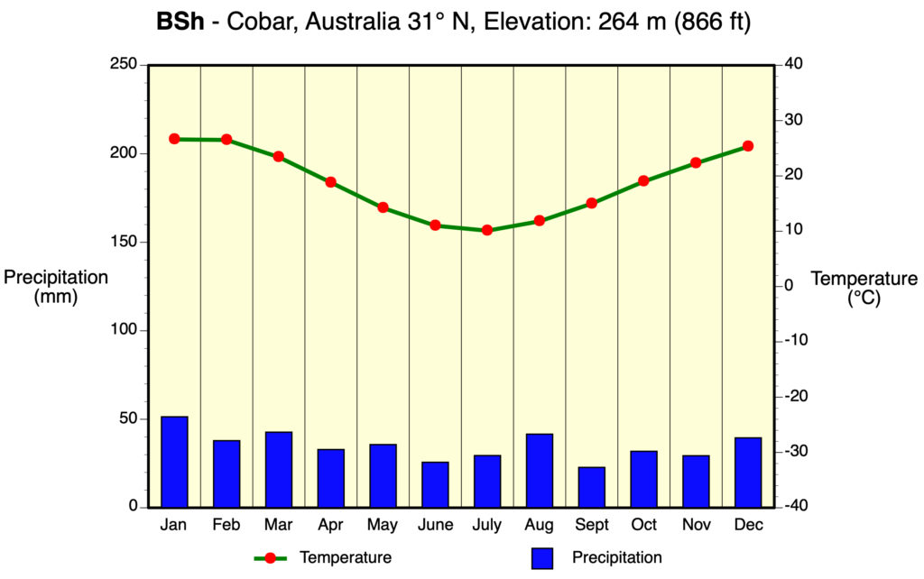
BSh – Semiarid Low Latitudes
BSh is a semiarid climate found in the low latitudes. Potential evapotranspiration exceeds precipitation on average but the difference between these two measures is less than what is found in a BWh climate. Annual average temperature is over 18°C (64°F). Annual precipitation totals greater than BWh climate.
Locations: About 13 to 15° North latitude in Africa, about 20° South latitude southern Africa, border areas around Australian desert, parts of southern South America, parts of India, and areas marginal to BWh climates of northwestern Africa, Saudi Arabia, and western India.
Example:
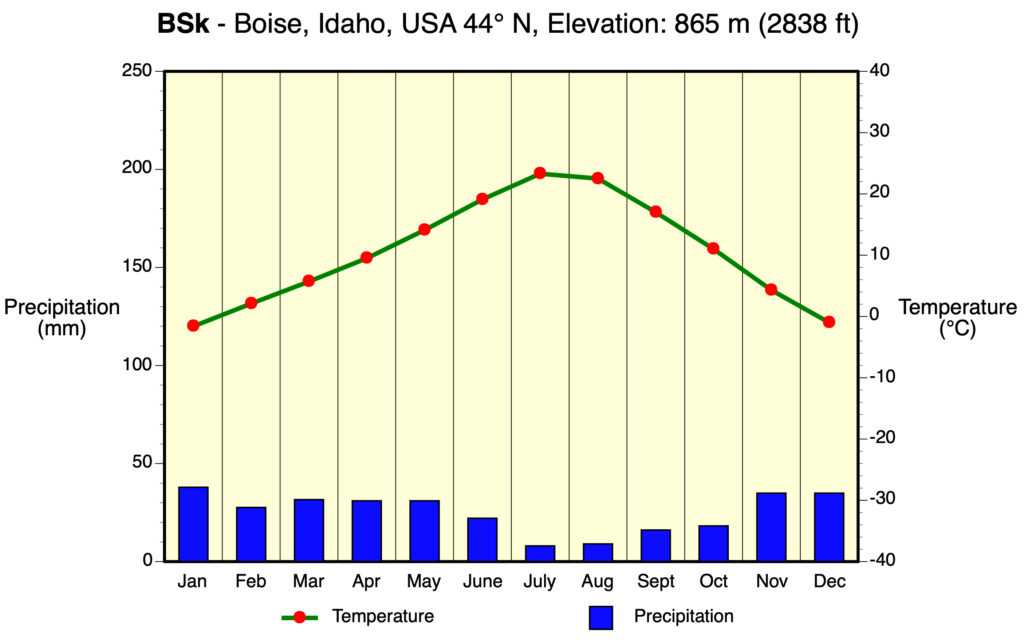
BSk – Semiarid Mid-Latitudes
BSk is a semiarid climate usually found in the middle latitudes. Potential evapotranspiration exceeds precipitation on average but the difference between these two measures is less than what is found in a BWk climate. Annual average temperature is below 18°C (64°F).
Locations: Western plains of the United States, south-central Canada, and borders BWh climate areas from the Caspian Sea eastward to China and Mongolia.
Controlling Weather Factors (both BSh and BSk): Weather is transitional between deserts and humid climates. Dominance of the Subtropical High Pressure Zone occurs during most of the year. Precipitation comes from brief incursions of the Intertropical Convergence Zone or from sporadic mid-latitude cyclones. Locations are often far inland (continentality) and influenced by rainshadow effect.
Climate Characteristics (both BSh and BSk): Climate is arid and air has low relative humidity. Rainfall is sporadic. Annual rainfall totals between 250 and 500 mm (10 and 20 in). Air temperatures for locations with this climate type vary greatly because of the effects of latitude, elevation, and continentality.
Example:
MOIST SUBTROPICAL MID-LATITUDE CLIMATES – “C” CLIMATES
This climate generally has warm and humid summers with mild winters. Its extent is from 30 to 50° of latitude mainly on the eastern and western borders of most continents. During the winter, the main weather feature is the mid-latitude cyclone. Convective thunderstorms provide precipitation in the summer months. Several dominant minor types exist:
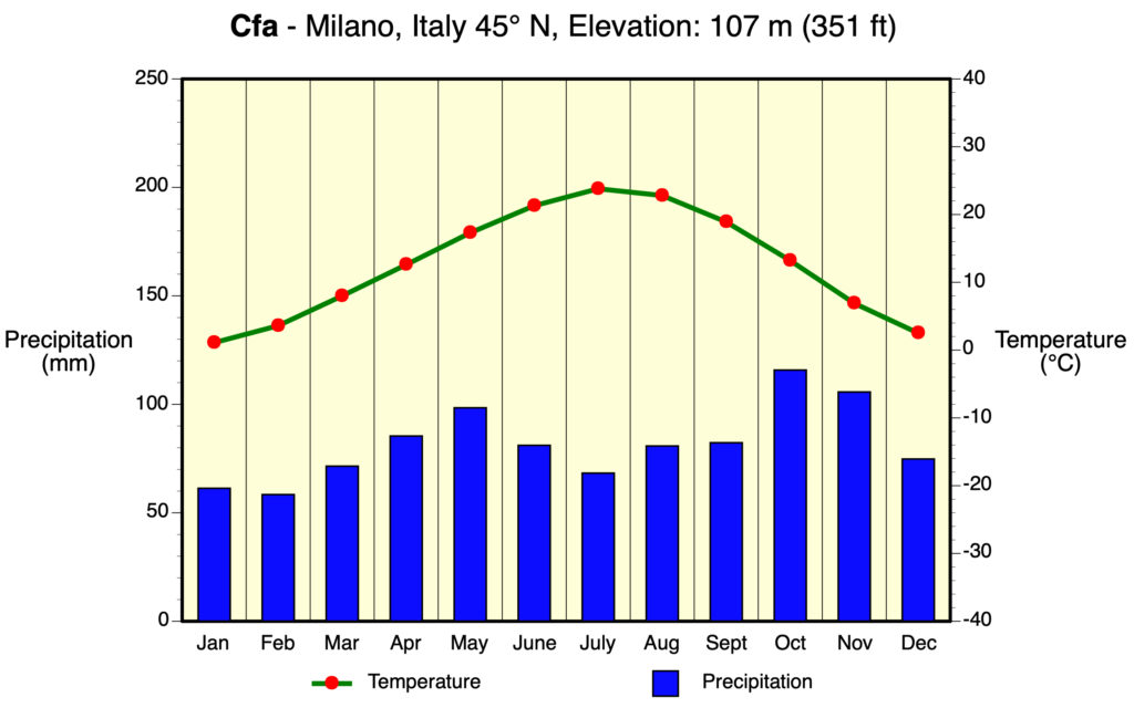
Cfa – Humid Subtropical
The humid subtropical climate (Cfa) has hot muggy summers and frequent thunderstorms. Winters are mild and precipitation during this season comes from mid-latitude cyclones. This climate type is quite common on the east coasts of continents. A good example of a region of the world with a Cfa climate is the southeastern USA. Average temperature of the warmest month is above 22°C (72°F). Average temperature of the coldest month is below 18°C (64°F) but above -3°C (27°F). Rainfall is equally spread out through the year.
Locations: Southeastern United States, northern Argentina, Uruguay, southern Brazil, southern Japan, and southern China.
Controlling Weather Factors: Mid-latitude cyclones in winter. Summer dominated by frequent thunderstorms because of the presence of Maritime Tropical Air masses and intense surface heating. Tropical storms and hurricanes during late summer and early fall can influence coastal regions of this climate type.
Climate Characteristics: High humidity occurs in summer months. Summer climate is much like humid tropics. Frost can occasionally occur with the presence of Continental Polar Air masses in winter. Precipitation varies from 650 to 2500 mm (26 and 98 in).
Example:
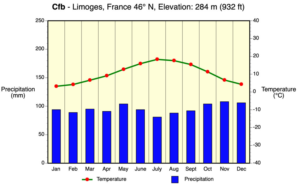
Cfb/Cfc – Marine
Cfb/Cfc marine climates are often found on the western coasts of continents. They have a humid climate with short dry summers. Heavy precipitation occurs during the mild winters because of the continuous presence of mid-latitude cyclones.
Cfb: Marine – Mild Winter
The average temperature of all months is less than 22°C (72°F). At least four months have an average temperature greater than 10°C (50°F). The average temperature of coldest month is below 18°C (64°F) but above -3°C (27°F). Precipitation is distributed evenly throughout year.
Cfc: Marine – Cool Winter
The average temperature of all months is less than 22°C (72°F). Only one to three months have an average temperature greater than 10°C (50°F). The average temperature of coldest month is below 18°C (64°F) but above -3°C (27°F). Precipitation is distributed equally throughout year.
Locations: Coastal Oregon, Washington, west coast of Canada and southern west coast of Alaska, central and northwest Europe, southern Chile, southern coast of South Africa, southeast Australia and New Zealand.
Controlling Weather Factors (both Cfb and Cfc): Mid-latitude cyclones influence weather for most of the year. Warm ocean currents keep these climates mild in winter and cool in the summer. Maritime Polar Air masses influence these climates during the winter season.
Climate Characteristics (both Cfb and Cfc): These climates have mild winters and cool summers with low annual temperature range. Weather activity at frontal zones produces heavy cloud cover and high humidity during fall, winter, and spring. Long periods of rain and drizzle from frequent occurrence of mid-latitude cyclones. Frost can sometimes occur during the winter season.
Example:
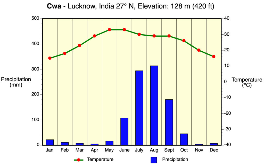
Cwa/Cwb/Cwc – Dry Winter, Wet Summer
Cwa/Cwb/Cwc dry winter, wet summer climates are generally found in the interiors of continents at the mid-latitudes. They have a humid climate with short dry summers. Heavy precipitation occurs during the summers because of the seasonal presence of unstable humid air masses that encourage the development of thunderstorms. These climates are quite limited in their distribution.
Locations (Cwa/Cwb/Cwc): Interior of central Mexico, northwestern Argentina, parts of Bolivia, Nepal, northern India, northern Bangladesh, northern Myanmar, parts of China, Angola, Zambia, Zimbabwe, and eastern South Africa.
Controlling Weather Factors (Cwa/Cwb/Cwc): Climate is influenced by hot and unstable humid air masses that dominate generally in late spring, summer, and early fall. Relatively dry winter season is often due to the presence dry Continental Polar Air masses.
Climate Characteristics (Cwa/Cwb/Cwc): High humidity occurs in summer months. Summer climate can be very similar to the humid tropics. Winters tend to be dry and cool.
Example:
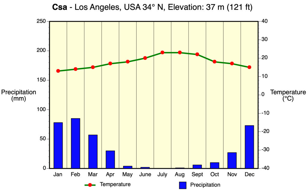
Csa/Csb – Mediterranean
Mediterranean climates (Csa/Csb) receive rain primarily during winter season from the mid-latitude cyclone. Extreme summer aridity is caused by the sinking air of the subtropical highs and may exist for up to 5 months. Locations in North America are from Portland, Oregon to all of California.
Csa: Interior Mediterranean
Warm mid-latitude climate with distinctly dry hot summer caused by continental high-pressure influence. Average temperature of the coldest month is less than 18°C (64°F) but above -3°C (27°F). Wettest winter month has about 3 times more precipitation when compared to the driest summer month. Precipitation in driest summer month is less than 40 mm (1.6 in). Warmest month has average temperature above 22°C (72°F) and at least 4 months have average temperatures above 10°C (50°F).
Csb: Coastal Mediterranean
Cool mid-latitude climate with distinctly dry cool summer caused by maritime high-pressure influence. Average temperature of the coldest month is less than 18°C (64°F) but above -3°C (27°F). Wettest winter month has about 3 times more precipitation when compared to the driest summer month. Precipitation in driest summer month is less than 40 mm (1.6 in). No month in this climate type has an average temperature above 22°C (72°F) and at least 4 months have average temperatures above 10°C (50°F).
Locations (both Csa and Csb): Interior and coastal areas of California, interior and coastal areas of Chile, area around the Mediterranean Sea, Iranian highlands, southwest tip of South Africa, and southern and southwestern regions of Australia.
Controlling Weather Factors (both Csa and Csb): Climate is influenced by subtropical highs in fall, summer, and spring and mid-latitude cycloness in winter.
Climate Characteristics (both Csa and Csb): Climate switches from mild, wet winters to hot, arid summers. This climate has a high percentage of sunshine. Diurnal range between maximum and minimum daily temperatures is quite large. Has some danger of frost during the winter season. Coastal locations can often experience low clouds and fog.
Example:
MOIST CONTINENTAL MID-LATITUDE CLIMATES – “D” CLIMATES
Moist continental mid-latitude climates have warm to cool summers and cold winters. The location of these climates is poleward of the C climates. The average temperature of the warmest month is greater than 10°C (50°F), while the coldest month is less than -3°C (27°F). Winters are severe with snowstorms, strong winds, and bitter cold from Continental Polar or Arctic Air masses. This climate has three second-level types: Dw – dry winters; Ds – dry summers; and Df – wet all year.
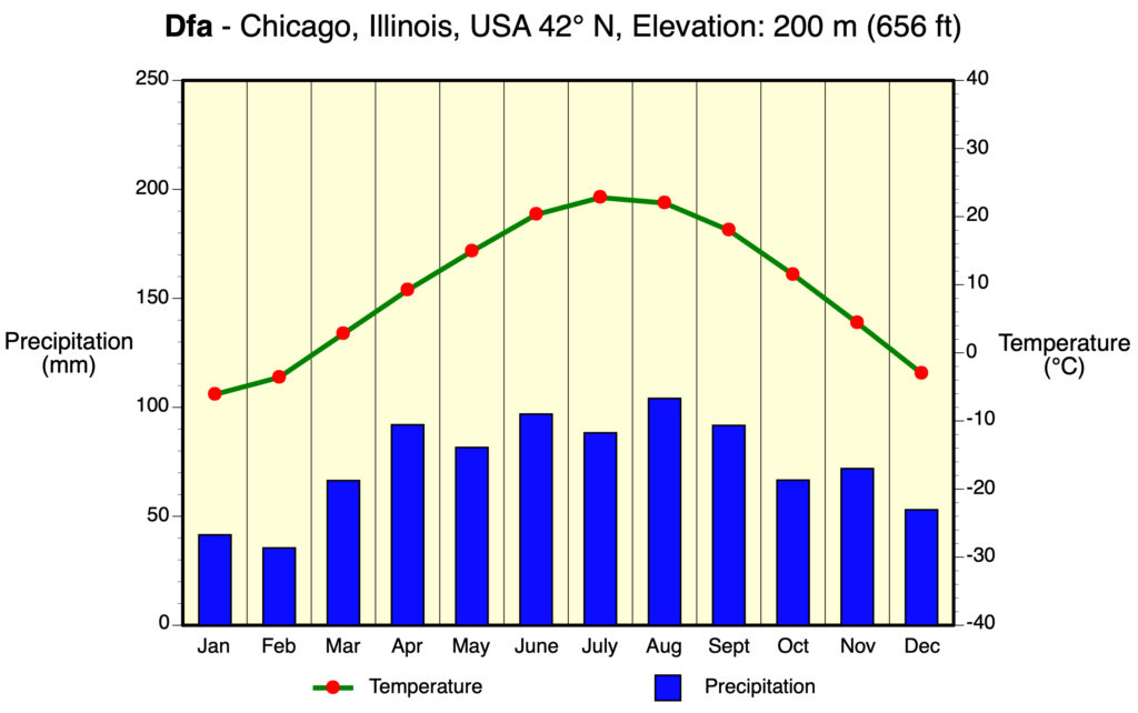
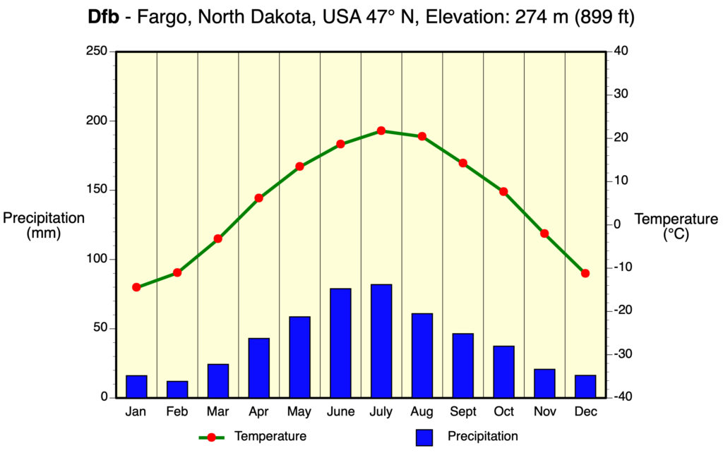
Dfa/Dwa
Dfa: Humid Continental Hot Summer, Wet All Year
Average temperature of the coldest month is -3°C (27°F) or lower. Average temperature of the warmest month is greater than 10°C (50°F). Precipitation is equally spread across the year.
Dwa: Humid Continental Hot Summer, Dry Winter
Average temperature of the coldest month is -3°C (27°F) or lower. Average temperature of the warmest month is greater than 10°C (50°F). Wettest summer month has about 10 times more precipitation when compared to the driest winter month.
Locations (both Dfa and Dwa): Northeastern and midwestern United States, east-central Europe, northern China, and northern Korea.
Controlling Weather Factors (both Dfa and Dwa): Weather influenced by mid-latitude cyclones that form along the polar front in fall, winter, and spring. Winter weather can be clear and cold when Continental Polar Air dominates. Occasional thunderstorms during summer months.
Climate Characteristics (both Dfa and Dwa): Climate has hot, often humid summers. Occasional winter spells with very cold temperatures and clear skies. Immense weather variability on yearly basis and quite large annual temperature ranges. Yearly precipitation total is between 500 to 1150 mm (20 and 45 in).
Example:
Dfb/Dwb
Dfb: Humid Continental Mild Summer, Wet All Year
Average temperature of the coldest month is -3°C (27°F) or lower. Average temperature of the warmest month is greater than 10°C (50°F). No month has an average temperature over 22°C (72°F). Precipitation is equally distributed across the year.
Dwb: Humid Continental Mild Summer, Dry Winter
Average temperature of the coldest month is -3°C (27°F) or lower. Average temperature of the warmest month is greater than 10°C (50°F). No month has an average temperature over 22°C (72°F). Wettest summer month has about 10 times more precipitation when compared to the driest winter month.
Locations (both Dfb and Dwb): New England and around the Great Lakes in the United States, south-central and southeastern Canada, southeastern Scandinavia, eastern Europe, west-central Asia, and northeastern China.
Controlling Weather Factors (both Dfb and Dwb): Weather influenced by mid-latitude cyclones that form along the polar front in fall, winter, and spring. Winter weather can be clear and cold when Continental Polar Air and Continental Arctic Air masses are present. Occasional thunderstorms during summer months.
Climate Characteristics (both Dfb and Dwb): Climate has mild summers. Long winters with frequent periods of very cold temperatures and clear skies. Immense weather variability on yearly basis and quite large annual temperature ranges. Yearly precipitation total is less than Dfa or Dwa climates.
Example:
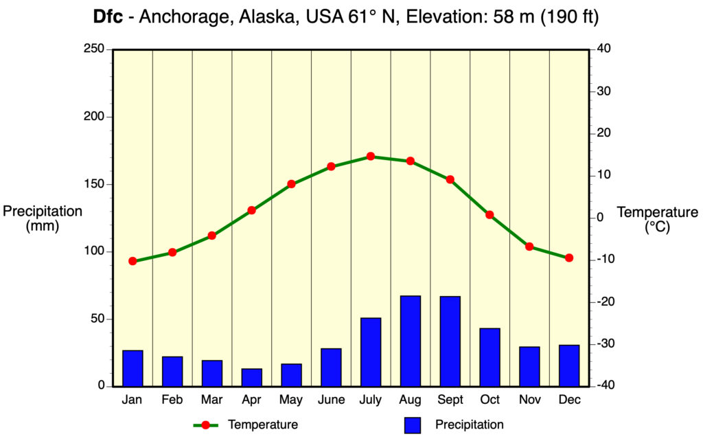
Dfc/Dwc/Dfd/Dwd
Dfc: Subarctic With Cool Summer, Wet All Year
Average temperature of the coldest month is -3°C (27°F) or lower. Average temperature of the warmest month is greater than 10°C (50°F). One to three months with an average temperature over 10°C (50°F). Precipitation is equally distributed across the year.
Dfd: Subarctic With Cold Winter, Wet All Year
Average temperature of the coldest month is -38°C (-36°F) or lower. Average temperature of the warmest month is greater than 10°C (50°F). Precipitation is evenly distributed over the year.
Dwc: Subarctic With Cool Summer, Dry Winter
Average temperature of the coldest month is -3°C (27°F) or lower. Average temperature of the warmest month is greater than 10°C (50°F). One to three months with an average temperature over 10°C (50°F). Wettest summer month has about 10 times more precipitation when compared to the driest winter month.
Dwd: Subarctic With Cold Winter, Dry Winter
Average temperature of the coldest month is -38°C (-36°F) or lower. Average temperature of the warmest month is greater than 10°C (50°F). Wettest summer month has about 10 times more precipitation when compared to the driest winter month.
Locations (Dfc, Dwc, Dfd and Dwd): Northern North America and northern Eurasia.
Controlling Weather Factors (Dfc, Dwc, Dfd and Dwd): Weather influenced by occasional mid-latitude cyclones in spring, summer, and fall. Continental Polar Air and Continental Arctic Air masses are dominant during much of the year.
Climate Characteristics (Dfc, Dwc, Dfd and Dwd): Climate has brief cool summer. Winters are very long with extended periods of extremely cold temperatures and clear skies. Immense weather variability on yearly basis and quite large annual temperature ranges. Permafrost is common in ground. Yearly precipitation total is between 250 to 500 mm (10 and 20 in).
Example:
POLAR CLIMATES – “E” CLIMATES
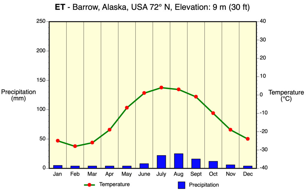
Polar climates have year-round cold temperatures with the warmest month less than 10°Celsius. Polar climates are found in the northern coastal areas of North America, Europe, Asia, and on the landmasses of Greenland and Antarctica. Two minor climate types exist. ET or polar tundra is a climate where the soil is permanently frozen to depths hundreds of meters, a condition known as permafrost. Vegetation is dominated by mosses, lichens, dwarf trees, and scattered woody shrubs. EF or polar ice cap has a surface that is permanently covered with snow and ice.
ET – Polar Tundra
Average temperature of warmest month for this climate is below 10°C (50°F) but is above 0°C (32°F). Precipitation generally is greater than potential evaporation.
Locations: Regions in North America, Greenland, and Eurasia that border the Arctic Ocean, Antarctic Peninsula, and many polar islands.
Controlling Weather Factors: Continual presence of Continental Arctic Air and Antarctic Air masses, polar vortex, and closeness to oceans.
Climate Characteristics: This climate essentially has no summer. At least 9 months have average temperatures below freezing. Very low evaporation because of cold temperatures. Precipitation is normally less than 250 mm (10 in). Winds tend to be strong and cold.
Example:
EF – Polar Ice Cap
Average temperature of warmest month for the EF climate is 0°C (32°F) or less. Precipitation generally is greater than potential evaporation.
Locations: Interior Greenland, most of Antarctica, and most Arctic Islands.
Controlling Weather Factors: Continual presence of Continental Arctic Air and Antarctic Air masses and polar vortex produce the planet’s coldest temperatures. Permanent ice cover and high elevations enhance the coldness of this climate.
Climate Characteristics: No summer and all average monthly temperatures are below freezing. Very low evaporation because of cold temperatures. Very small amounts of precipitation occur, mainly falling as snow.
Example:

Köppen Maps PDF Files
Köppen Decision System PDF
This Appendix is Licensed Under Attribution-NonCommercial-NoDerivatives 4.0 International (CC BY-NC-ND 4.0).
Updated April 4, 2021
General pattern of weather conditions for a region over a long period time (at least 30 years).
The state of the atmosphere in the terms of measured meteorological variables and observed atmospheric phenomena for a particular place or region, for a moment or period in time.
Temperature is defined as the measure of the average speed of atoms and molecules. The higher the temperature the faster they move.
Is any aqueous deposit, in liquid or solid form, that develops in a saturated atmosphere (relative humidity equals 100%) and falls to the ground generally from clouds. Most clouds, however, do not produce precipitation. In many clouds, water droplets and ice crystals are too small to overcome natural updrafts found in the atmosphere. As a result, the tiny water droplets and ice crystals remain suspended in the atmosphere as clouds. Some forms of precipitation include rain, snow, drizzle, hail, ice pellets, and snow pellets.
A general term used to describe the amount of water vapor found in the atmosphere. Also see relative humidity, vapor pressure, and mixing ratio.
System that uses monthly precipitation and temperature data and total annual precipitation data to classify a location's climate into one of five main categories: Tropical Moist Climates (A); Dry Climates (B); Moist Mid-latitude Climates with Mild Winters; (C) Moist Mid-Latitude Climates with Cold Winters (D); and Polar Climates (E). These categories are further divided into number of subcategories. First developed in 1918 by German biologist W. Köppen, this system has undergone a number of modifications.
The occurrence of rain falling from clouds to the Earth’s surface.
Puffy clouds with relatively flat bases. Cumulus clouds form when moist warm air bubbles vertically escape from the Earth's surface. Found in an altitude range between 300 to 2000 meters (984 to 6560 feet).
A well developed vertical cloud that often displays a top shaped like an anvil. Cumulonimbus clouds are very dense with condensed water droplets and deposited ice crystals. Common weather associated with this cloud includes: strong winds; hail; lightning; tornadoes; thunder; and heavy rain. When this weather occurs these clouds are then officially called thunderstorms. These clouds can extend in altitude from a few hundred meters above the surface to more than 12,000 meters (39,400 feet).
A storm that typically ranges in size from several kilometers (several miles) to over 50 kilometers (30 miles) in diameter created by the quick lifting of moist warm air which creates a cumulonimbus cloud. Thunderstorms can occur in isolation as a single celled storm or as a multi-celled storm arranged in a cluster or as a line of adjacent cells (called a squall line) found along or ahead of a mid-latitude cyclone cold front. Thunderstorms can have the following severe weather associated with them: strong winds; hail; lightning; tornadoes; thunder; and heavy rain.
Process where an object cools in temperature and experiences a reduction in internal heat energy because of the net loss of radiation. This net loss of radiation occurs because outgoing radiation exceeds incoming radiation for the object.
Electromagnetic radiation that originates from the Sun. Most of the Sun's radiation is emitted at wavelengths between 1.0 and 0.1 microns (µm). Also see insolation, direct solar radiation, and diffused solar radiation.
Zone of low atmospheric pressure and ascending air located at or near the equator. The rising air currents at the ITCZ are the result of global wind convergence and convection from thermal heating. The ITCZ generally has the same geographic location as the thermal equator.
An extensive region of surface atmospheric high pressure located at about 30° North and South latitude. These high pressure systems produced by vertically descending air currents from the Hadley Cell.
Zone of low atmospheric pressure and ascending air located at or near the equator. Rising air currents are due to global wind convergence and convection from thermal heating. Location of the thermal equator.
The forced uplift of an air mass because of the presence of a topographic obstruction. This uplift also causes the cooling of the air mass. If enough cooling occurs condensation can occur and form into orographic precipitation. Also called orographic lifting.
Is a measure of the ability of the atmosphere to remove water from the surface through the processes of evaporation and transpiration assuming no limitation on water supply.
A plant that has adaptations to survive long periods of drought.
The tendency of terrestrial surfaces on Earth to experience more temperature variation than ocean surfaces. The main factor responsible for this fact is that the soil, sediment, and rock that makes up land has a lower specific heat than water.
The reduction of precipitation commonly found on the leeward side of a mountain. This reduction in precipitation is the result of compression warming of descending air.
Cyclonic storm that forms primarily in the middle latitudes. The formation of these storms is triggered by the development of troughs in the polar jet stream. These storms also contain warm, cold, and occluded fronts. Atmospheric pressure in their center can get as low as 970 millibars. Also called wave cyclones or frontal cyclones.
The ratio between the actual amount of water vapor held in the atmosphere compared to the amount required for saturation. Relative humidity is influenced by temperature and atmospheric pressure.
Cyclonic storm that forms primarily in the middle latitudes. Its formation is triggered by the development of troughs in the polar jet stream. These storms also contain warm, cold and occluded fronts. Atmospheric pressure in their center can get as low as 970 millibars. Also called wave cyclones or frontal cyclones.
Air mass that forms over extensive ocean areas of the low latitudes. Around North America, these system form over the Gulf of Mexico and the eastern tropical Pacific. Maritime Tropical air masses are warm and humid in both winter and summer. In the Northern Hemisphere, maritime tropical air masses can normally stable during the whole year if they have form just west of a continent. If they form just east of a continent, these air masses will be unstable in both winter and summer.
An organized group of thunderstorms often found over a tropical ocean that generates a cyclonic flow of between 64 and 118 kilometers per hour (39 to 73 miles per hour). Often develops into a hurricane.
An intense cyclonic storm consisting of an organized mass of thunderstorms that develops over the warm oceans of the tropics. To be classified as a hurricane, wind speeds in the storm must be greater than 118 kilometers per hour (73 miles per hour).
Air mass that forms over extensive landmass areas of middle to high latitudes. In North America, these systems form over northern Canada. Continental Polar air masses are cold and very dry in the winter and cool and dry in the summer. These air masses are also atmospherically stable in all seasons.
Large scale horizontal flow of ocean water that is persistent and driven by atmospheric circulation.
Air mass that forms over extensive ocean areas of the middle to high latitudes. Around North America, these air mass system form over the Atlantic and Pacific oceans at the middle latitudes. Maritime Polar air masses are mild and humid in summer and cool and humid in winter. In the Northern Hemisphere, maritime polar air masses are normally unstable during the winter. In the summer, atmospheric stability depends on the position of the air mass relative to a continent. Around North America, Maritime Polar air masses found over the Atlantic are stable in summer, while Pacific systems tend to be unstable.
A transition area that exists between two air masses with different air temperature and/or humidity characteristics. Differences in air temperature and/or humidity causes the air mass with lower air density to be pushed over the denser air mass. This process is known as frontal lifting and can result in the development of clouds and precipitation.
A form of precipitation. It is any liquid deposit that falls from clouds in the atmosphere to the ground surface. Rain normally has a diameter between than 0.5 and 5.0 millimeters.
A form of precipitation where the water droplets are smaller than rain. Drizzle has a size that is between 0.2 and 0.5 mm (0.008 to 0.02 in) in diameter.
Deposition of ice crystals on the surface of an object because of atmospheric cooling.
An atmospheric condition near the Earth’s surface where minute water droplets, ice crystals or smoke particles reduce visibility. Fog exists if the atmospheric visibility near the Earth's surface is reduced to 1 kilometer (0.62 miles) or less. Fogs composed primarily of water droplets are classified according to the process that causes the air to cool to saturation.
Air mass that forms over extensive landmass areas of middle to high latitudes. In North America, these systems form over northern Canada. Continental Polar air masses are cold and very dry in the winter and cool and dry in the summer. These air masses are also atmospherically stable in all seasons. On weather maps, the symbol cP is used to identify a Continental Polar air mass.
Air mass that forms over extensive landmass areas of the high latitudes. In the Northern Hemisphere, these systems form only in winter over Greenland, northern Canada, northern Siberia, and the Arctic Basin. Continental Arctic air masses are very cold and extremely dry. These air masses are very stable.
Weather front located typically in the mid-latitudes that separates arctic and polar air masses from tropical air masses. Along the polar front we get the development of the mid-latitude cyclone. Above the polar front exists the polar jet stream.
Air mass that forms over extensive landmass areas of middle to high latitudes. In North America, these systems form over northern Canada. Continental Polar air masses are cold and very dry in the winter and cool and dry in the summer. These air masses are also atmospherically stable in all seasons.
Air mass that forms over extensive landmass areas of the high latitudes. In the Northern Hemisphere, these systems form only in winter over Greenland, northern Canada, northern Siberia, and the Arctic Basin. Continental Arctic air masses are very cold and extremely dry. These air masses are very stable.
Air mass that forms over extensive landmass areas of the high latitudes. In the Northern Hemisphere, these systems form only in winter over Greenland, northern Canada, northern Siberia, and the Arctic Basin. Continental Arctic air masses are very cold and extremely dry. These air masses are very stable.
Zone of permanently frozen water found in high latitude soils and sediments. Five types of permafrost have been recognized: continuous permafrost, discontinuous permafrost, sporadic permafrost, alpine permafrost, and subsea permafrost.
A type of solid precipitation that forms in clouds with an air temperature below freezing. Snow forms when water vapor deposits directly as a solid on a deposition nuclei. Snowflakes begin their life as very tiny crystals developing on a six-sided hexagonal deposition nuclei. The developing snowflake, then grows fastest at the six points of the nuclei as these surfaces are more exposed to atmosphere’s water vapor. Snowfall is most common with the frontal lifting associated with mid-latitude cyclones during fall, winter, and spring months when air temperatures are below freezing.
Air mass that forms over the Antarctic landmass in the Southern Hemisphere. These air mass systems form during the entire year. Continental Antarctic air masses are very cold and extremely dry. These air masses are very stable.
High pressure system located in the upper atmosphere at the polar regions. In this system, air in the upper troposphere moves into the vortex center and then descends to the Earth's surface to create the polar highs.
Evaporation can be defined as the process by which liquid water is converted into a gaseous state. Evaporation can only occur when water is available. It also requires that the humidity of the atmosphere be less than the evaporating surface (at 100% relative humidity there is no more evaporation). The evaporation process requires large amounts of energy. For example, the evaporation of one gram of water at a temperature of 100°C requires 540 calories of heat energy (600 calories at 0°C).
