Michael Pidwirny
LABORATORY 5: CLASSIFICATION OF GLOBAL CLIMATES
LEARNING GOALS
In this laboratory, we will examine the classification of climates for places found on our planet.
Upon completion of this laboratory you will be able to:
- Use the Köppen Climate Classification system to categorize the climates of places.
- Understand the climatic factors responsible for the types of climates located on our planet.
- Recognize climatic similarities between spatially isolated locations found on the Earth.
INTRODUCTION
Climate can be defined as the long-term trends observed in the state of the weather (temperature, precipitation, humidity, etc.) on a time-scale of years to decades. Understanding these trends allows us to make predictions about what the weather may be like in the immediate future. Several systems have been developed for classifying the climates of locations found on our planet. The classification of data is a common process in all sciences. From the classification process, we can determine similarities and dissimilarities in the data. The classification process also helps us to identify patterns in data that are usually controlled by other factors. In terms of the climate of locations found on the Earth, we will discover that locations with comparable climates are often influenced by similar climatic factors despite being geographically separated by great distances.
The Köppen Climate Classification system is an empirical system that uses readily available precipitation and temperature data collected at weather stations. For the classification process, the data must be arranged as monthly totals of precipitation, monthly temperatures, annual total of precipitation, and annual temperature. Monthly temperature is calculated by first determining the daily means for all days in the month by finding the average of daily maximum and daily minimum temperatures. All of the daily means are then added together and then divided by a value equal to the number of days in that particular month. Finally, monthly and annual temperature and precipitation data should be averaged over a number of consecutive years. This averaging evens out the natural variation normally found in climate data.
TROPICAL MOIST CLIMATES – “A” CLIMATES
Tropical moist climates extend northward and southward from the equator to about 15 to 25° of latitude. In these climates, all months have average temperatures greater than 18°Celsius. Annual precipitation is often greater than 1500 mm. Three minor Köppen climate types exist in the A group. These three categories of tropical moist climate are distinguished by the seasonal distribution of rainfall.
Af – Tropical Wet
Af or tropical wet (also called tropical rainforest) is a tropical climate where precipitation occurs all year long. Monthly temperature variations in this climate are usually less than 3°Celsius (C). Because of intense surface heating and high humidity, cumulus and cumulonimbus clouds (thunderstorms) form early in the afternoons almost every day. Daily highs are about 32°C. Radiative cooling during the evening is limited because of cloud cover and high humidity. Nighttime daily temperatures average about 22°C.
Locations: Amazon River Basin (South America), Congo River Basin (Africa), eastern coast of Central America, eastern coast of Brazil, the Philippines, coast of Madagascar, eastern India, southern Bangladesh, Malaysia, and Indonesia.
Controlling Weather Factors: High year-round input of high quantities of solar radiation (insolation). High and constant monthly precipitation because of the presence of thunderstorm activity associated with the Intertropical Convergence Zone.
Climate Characteristics: Constant high temperatures throughout the year. Average monthly temperatures are very similar – yearly range is about 2 to 3°C. Monthly precipitation is evenly distributed and annual amounts are usually greater than 1500 mm. These climates also have frequent cumulus cloud development with some of these clouds becoming air mass thunderstorms. Humidity tends to be high.
Am – Tropical Monsoon
Am is a tropical monsoon climate. Annual rainfall is equal to or greater than Af, but most of the precipitation falls in the 7 to 9 hottest months. Have a very pronounced wet season. During the dry season, very little rainfall occurs. Average monthly temperatures for all months is greater than 18°C. Have one or more months with less than 60 mm of precipitation.
Locations: Coastal areas of southwestern India, Sri Lanka, Bangladesh, Myanmar, southwestern Africa, Guyana, Surinam, French Guiana, and parts of northeast and southeast Brazil.
Controlling Weather Factors: Monsoonal summer onshore and winter offshore air mass movement related to shifting Intertropical Convergence Zone and changing pressure conditions over the landmasses and ocean areas involved.
Climate Characteristics: Climate of this category is transitional between Af and Aw. Heaviest rainfall records in world occur in this climate type (Cherripunji, India – 12,000 mm). Heavy rainfall is associated with the high-sun (summer) season. Precipitation can be greatly enhanced by orographic uplift. Yearly precipitation totals range from between 1500 to 4000 mm. The dry season is associated with the low-sun (winter) period. Annual temperature range of monthly averages is about 2 to 6°C. Highest monthly temperature often occurs just prior to the start of the rainy season.
Aw – Tropical Wet and Dry
The tropical wet and dry or savanna (Aw) has an extended dry season during winter. Precipitation during the wet season is usually less than 1000 millimeters, and only during the summer season. Average monthly temperatures for all months are greater than 18°C. More than two months have less than 60 mm of precipitation. There is a distinct dry season during the low-sun period (winter) and a distinct wet season during the high-sun period (summer). These climates are generally pole ward of Af climate areas.
Locations: Northern and eastern India, central Myanmar, the Indo-Chinese Peninsula, northern Australia, the region around the Congo River basin, south-central Africa, western Central America, parts of Venezuela, and parts of Brazil, southern tip of Florida, and the Caribbean Islands.
Controlling Weather Factors: alternating wet and dry seasons caused by the seasonal presence of the Intertropical Convergence Zone during the high-sun season and the Subtropical High Pressure Zone during the low-sun season.
Climate Characteristics: Monthly precipitation data shows distinct high-sun wet and low-sun dry seasons. Annual rainfall averages between 750 and 1800 mm. This climate has the highest monthly temperature ranges of the A climate category.
DRY CLIMATES – “B” CLIMATES
The most obvious climatic feature of this climate is that potential evapotranspiration exceeds precipitation. These climates extend from 20 – 35° North and South of the equator and in large continental regions of the mid-latitudes often surrounded by mountains. Four minor types of this climate occur:
BW – Dry Arid
BW – dry arid (desert) is a true desert climate. It covers 12 % of the Earth’s land surface and is dominated by xerophytic vegetation. The additional letters h and k are used generally to distinguish whether the dry arid climate is found in the subtropics or in the mid-latitudes, respectively.
BWh – Dry Arid Low Latitudes
BWh is a dry arid climate found in low latitude deserts. The most distinguishing aspect of this climate is that precipitation is less than 50% of potential evapotranspiration. Annual average temperature is over 18°C. Daily minimum temperatures infrequently go below 0°C during the winter season.
Locations: Northern Mexico, southwestern United States, northern Africa Saudi Arabia, Iran, western India, central and western Australia, and southern and western Africa.
BWk – Dry Arid Mid-Latitudes
BWk is a dry arid climate found in middle latitude deserts. Like BWh, precipitation is less than half of potential evapotranspiration. Annual average temperature is below 18°C. Daily minimum temperatures can frequently go below 0°C during the winter season.
Locations: From the Caspian Sea eastward to northern China, Mongolia, and parts of southern South America.
Controlling Weather Factors (both BWh and BWk): Dominance of the Subtropical High Pressure Zone during most of the year. Locations are often far inland (continentality) and may be influenced by rain shadow effect.
Climate Characteristics (both BWh and BWk): Climate is very arid and air has low relative humidity. Rainfall is very irregular and unreliable. Annual rainfall totals less than 250 mm. BWh/k has the highest percentage of sunshine of all climate types. Diurnal (day to night) temperature ranges are the greatest of all climate types. Daily maximum temperatures are very high. Generally, windy conditions persist during the day.
BS – Dry Semiarid (Steppe)
This is a grassland climate that covers 14 % of the Earth’s land surface. It receives more precipitation than the BW either from short incursions of the Intertropical Convergence Zone or from occasional mid-latitude cyclones. Once again, the additional letters h and k are used generally to distinguish whether the dry semiarid climate is found in the subtropics or in the mid-latitudes, respectively.
BSh – Semiarid Low Latitudes
BSh is a semiarid climate found in the low latitudes. Potential evapotranspiration exceeds precipitation on average but the difference between these two measures is less than what is found in a BWh climate. Annual average temperature is over 18°C. Annual precipitation totals greater than BWh climate.
Locations: About 13 to 15° North latitude in Africa, about 20° South latitude southern Africa, border areas around the Australian desert, parts of southern South America, parts of India, and areas marginal to BWh climates of northwestern Africa, Saudi Arabia, and western India.
BSk – Semiarid Mid-Latitudes
BSk is a semiarid climate usually found in the middle latitudes. Potential evapotranspiration exceeds precipitation on average but the difference between these two measures is less than what is found in a BWk climate. Annual average temperature is below 18°C.
Locations: Western plains of the United States, south-central Canada, and borders BWh climate areas from the Caspian Sea eastward to China and Mongolia.
Controlling Weather Factors (both BSh and BSk): Weather is transitional between deserts and humid climates. The dominance of the Subtropical High Pressure Zone occurs during most of the year. Precipitation comes from brief incursions of the Intertropical Convergence Zone or from sporadic mid-latitude cyclones. Locations are often far inland (continentality) and may be influenced by rain shadow effect.
Climate Characteristics (both BSh and BSk): Climate is arid and air has low relative humidity. Rainfall is sporadic. Annual rainfall totals between 250 and 500 mm. Air temperatures vary greatly because of the effects of latitude, elevation, and continentality.
MOIST SUBTROPICAL MID-LATITUDE CLIMATES – “C” CLIMATES
Moist subtropical mid-latitude C climates generally have warm and humid summers with mild winters. Its extent is from 30 to 50° of latitude mainly on the eastern and western borders of most continents. During the winter, the main weather feature is the mid-latitude cyclone. Convective thunderstorms provide precipitation in the summer months. Several dominant minor types exist:
Cfa – Humid Subtropical
The humid subtropical climate (Cfa) has hot muggy summers and frequent thunderstorms. Winters are mild and precipitation during this season comes from mid-latitude cyclones. This climate type is quite common on the east coasts of continents. A good example of a region of the world with a Cfa climate is the southeastern USA. Average temperature of the warmest month is above 22°C. Average temperature of the coldest month is below 18°C but above -3°C. Rain is equally spread out over the year.
Locations: Southeastern United States, northern Argentina, Uruguay, southern Brazil, southern Japan, and southern China.
Controlling Weather Factors: Mid-latitude cyclones in winter. Summer dominated by frequent thunderstorms because of intense surface heating and the presence of Maritime Tropical air masses.
Climate Characteristics: High humidity occurs in the summer months. The summer climate is much like the humid tropics. Frost can occasionally occur with the presence of Continental Polar air masses in winter. Precipitation varies from 650 to 2500 mm.
Cfb/Cfc – Marine
Cfb/Cfc marine climates are usually found on the western coasts of continents. They have a humid climate with short dry summers. Heavy precipitation occurs during the mild winters because of the continuous presence of mid-latitude cyclones.
Cfb – Marine Coast – Mild Winter
The average temperature of all months is less than 22°C. At least four months have an average temperature greater than 10°C. The average temperature of the coldest month is below 18°C but above -3°C. Precipitation is distributed evenly throughout the year.
Cfc – Marine Coast – Cool Winter
The average temperature of all months is less than 22°C. One to three months have an average temperature greater than 10°C. The average temperature of the coldest month is below 18°C but above -3°C. Precipitation is distributed equally throughout the year.
Locations: Coastal Oregon, Washington, west coast of Canada and southern west coast of Alaska, central and northwest Europe, southern Chile, southern coast of South Africa, southeast Australia and New Zealand.
Controlling Weather Factors (both Cfb and Cfc): Mid-latitude cyclones influence weather for most of the year. Warm ocean currents keep these climates mild in winter and cool in the summer.
Climate Characteristics (both Cfb and Cfc): These climates have mild winters and cool summers with low annual temperature range. Frontal activity produces heavy cloud cover and high humidity during fall, winter, and spring. Long periods of rain and drizzle from the frequent occurrence of mid-latitude cyclones. Frost can sometimes occur during the winter season.
Csa/Csb – Mediterranean
Mediterranean climates (Csa/Csb) receive rain primarily during the winter season from the mid-latitude cyclone. Extreme summer aridity is caused by the sinking air of the subtropical highs and may exist for up to 5 months. Locations in North America are from Portland, Oregon to all of California.
Csa – Interior Mediterranean
Warm mid-latitude climate with distinctly dry hot summer caused by continental high-pressure influence. Average temperature of the coldest month is less than 18°C but above -3°C. Wettest winter month has about 3 times more precipitation when compared to the driest summer month. Precipitation in driest summer month is less than 40 mm. Warmest month has average temperature above 22°C and at least 4 months have average temperatures above 10°C.
Csb – Coastal Mediterranean
Cool mid-latitude climate with distinctly dry cool summer caused by maritime high-pressure influence. Average temperature of the coldest month is less than 18°C but above -3°C. Wettest winter month has about 3 times more precipitation when compared to the driest summer month. Precipitation in driest summer month is less than 40 mm. No month with an average temperature above 22°C and at least 4 months have average temperatures above 10°C.
Locations (both Csa and Csb): Interior and coastal areas of California, interior and coastal areas of Chile, area around the Mediterranean Sea, Iranian highlands, southwest tip of South Africa, and southern and southwestern regions of Australia.
Controlling Weather Factors (both Csa and Csb): Climate is influenced by subtropical highs in fall, summer, and spring and mid-latitude cyclones in winter.
Climate Characteristics (both Csa and Csb): Climate switches from mild, wet winters to hot, arid summers. This climate has a high percentage of sunshine. Diurnal range between maximum and minimum daily temperatures is quite large. Has some danger of frost during winter season. Coastal locations can often experience low clouds and fog.
MOIST CONTINENTAL MID-LATITUDE CLIMATES – “D” CLIMATES
Moist continental mid-latitude D climates have warm to cool summers and cold winters. The location of these climates is pole ward of the C climates. The average temperature of the warmest month is greater than 10°C, while the coldest month is less than -3°C. Winters are severe with snowstorms, strong winds, and bitter cold from Continental Polar or Arctic air masses. This climate has three second-level types: Dw – dry winters; Ds – dry summers; and Df – wet all year.
Dfa/Dwa
Dfa – Humid Continental Hot Summer, Wet All Year
Average temperature of the coldest month is -3°C or lower. Average temperature of the warmest month is greater than 10°C. Precipitation is equally spread across the year.
Dwa – Humid Continental Hot Summer, Dry Winter
Average temperature of the coldest month is -3°C or lower. Average temperature of the warmest month is greater than 10°C. Wettest summer month has about 10 times more precipitation when compared to the driest winter month.
Locations (both Dfa and Dwa): northeastern and mid-western United States, east-central Europe, northern China, and northern Korea.
Controlling Weather Factors (both Dfa and Dwa): Weather influenced by mid-latitude cyclones that form along the polar front in fall, winter, and spring. Winter weather can be clear and cold when Continental Polar air dominates. Occasional thunderstorms during summer months.
Climate Characteristics (both Dfa and Dwa): Climate has hot, often humid summers. Occasional winter spells with very cold temperatures and clear skies. Immense weather variability on yearly basis and quite large annual temperature ranges. Yearly precipitation total is between 500 to 1150 mm.
Dfb/Dwb
Dfb – Humid Continental Mild Summer, Wet All Year
Average temperature of the coldest month is -3°C or lower. Average temperature of the warmest month is greater than 10°C. No month has an average temperature over 22°C. Precipitation is equally distributed across the year.
Dwb – Humid Continental Mild Summer, Dry Winter
Average temperature of the coldest month is -3°C or lower. Average temperature of the warmest month is greater than 10°C. No month has an average temperature over 22°C. Wettest summer month has about 10 times more precipitation when compared to the driest winter month.
Locations (both Dfb and Dwb): New England and around the Great Lakes in the United States, south-central and southeastern Canada, southeastern Scandinavia, eastern Europe, west-central Asia, and north-eastern China.
Controlling Weather Factors (both Dfb and Dwb): Weather influenced by mid-latitude cyclones that form along the polar front in fall, winter, and spring. Winter weather can be clear and cold when Continental Polar and Arctic air masses are present. Occasional thunderstorms during summer months.
Climate Characteristics (both Dfb and Dwb): Climate has mild summers. Long winters with frequent periods of very cold temperatures and clear skies. Immense weather variability on yearly basis and quite large annual temperature ranges. Yearly precipitation total is less than Dfa or Dwa climates.
Dfc/Dwc/Dfd/Dwd
Dfc – Subarctic With Cool Summer, Wet All Year
Average temperature of the coldest month is -3°C or lower. Average temperature of the warmest month is greater than 10°C. One to three months with an average temperature over 10°C. Precipitation is equally distributed across the year.
Dfd – Subarctic With Cold Winter, Wet All Year
Average temperature of the coldest month is -38°C or lower. Average temperature of the warmest month is greater than 10°C. Precipitation is evenly distributed over the year.
Dwc – Subarctic With Cool Summer, Dry Winter
Average temperature of the coldest month is -3°C or lower. Average temperature of the warmest month is greater than 10°C. One to three months with an average temperature over 10°C. Wettest summer month has about 10 times more precipitation when compared to the driest winter month.
Dwd – Subarctic With Cold Winter, Dry Winter
Average temperature of the coldest month is -38°C or lower. Average temperature of the warmest month is greater than 10°C. Wettest summer month has about 10 times more precipitation when compared to the driest winter month.
Locations (Dfc, Dwc, Dfd and Dwd): Northern North America and northern Eurasia.
Controlling Weather Factors (Dfc, Dwc, Dfd, and Dwd): Weather influenced by occasional mid-latitude cyclones in spring, summer, and fall. Continental Polar and Arctic air masses are dominant during much of the year.
Climate Characteristics (Dfc, Dwc, Dfd, and Dwd): Climate has brief cool summer. Winters are very long with extended periods of extremely cold temperatures and clear skies. Immense weather variability on yearly basis and quite large annual temperature ranges. Permafrost common. Yearly precipitation total is between 250 to 500 mm.
POLAR CLIMATES – “E” CLIMATES
Polar E climates have year-round cold temperatures with the warmest month less than 10°Celsius. Polar climates are found in the northern coastal areas of North America, Europe, Asia, and on the landmasses of Greenland and Antarctica. Two minor climate types exist. ET or polar tundra is a climate where the soil is permanently frozen to depths of hundreds of meters, a condition known as permafrost. Vegetation is dominated by mosses, lichens, dwarf trees, and scattered woody shrubs. Locations designated EF or polar ice caps have a surface that is permanently covered with snow and ice.
ET – Polar Tundra
Average temperature of the warmest month for this climate is below 10°C but is above 0°C. Precipitation generally is greater than potential evaporation.
Locations: Regions in North America, Greenland, and Eurasia that border the Arctic Ocean, Antarctic Peninsula, and many polar islands.
Controlling Weather Factors: Continual presence of Arctic and Antarctic air masses, polar vortex, and closeness to oceans.
Climate Characteristics: This climate essentially has no summer. At least 9 months have average temperatures below freezing. Low evaporation due to cold temperatures. Precipitation is normally less than 250 mm. Winds tend to be strong and cold.
EF – Polar Icecap
Average temperature of the warmest month for the EF climate is 0°C or less. Precipitation generally is greater than potential evaporation.
Locations: Interior Greenland, most of Antarctica, and most Arctic Islands.
Controlling Weather Factors: Continual presence of Arctic air masses and Antarctic air masses, and the polar vortex produce the planet’s coldest temperatures. Permanent ice cover and high elevations enhance the coldness of this climate.
Climate Characteristics: No summer and all average monthly temperatures are below freezing. Very low evaporation because of cold temperatures. Very small amounts of precipitation occur, mainly falling as snow.
LABORATORY 5 QUESTIONS
With the help of the file Lab5 Koppen Classification Guide.pdf, classify the following locations using the available data according to the Köppen Climate Classification system.
QUESTION 1
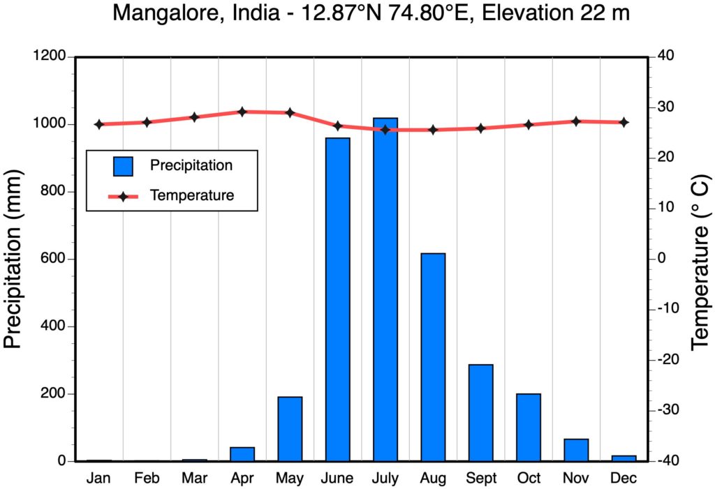
1.1) What is Mangalore’s Köppen Climate Classification?
1.2) What climate factors are responsible for Mangalore’s wet season (June to August)?
A Monsoons.
B Intertropical Convergence Zone.
C Mid-latitude Cyclones.
D Hurricances.
1.3) Peak input of solar radiation to this location should occur in June and July. As a result, these months should have the warmest temperatures. Yet the monthly mean temperatures in April and May are warmer. What factor (associated with the rainfall) may be limiting how much solar radiation is being received? Explain.
QUESTION 2
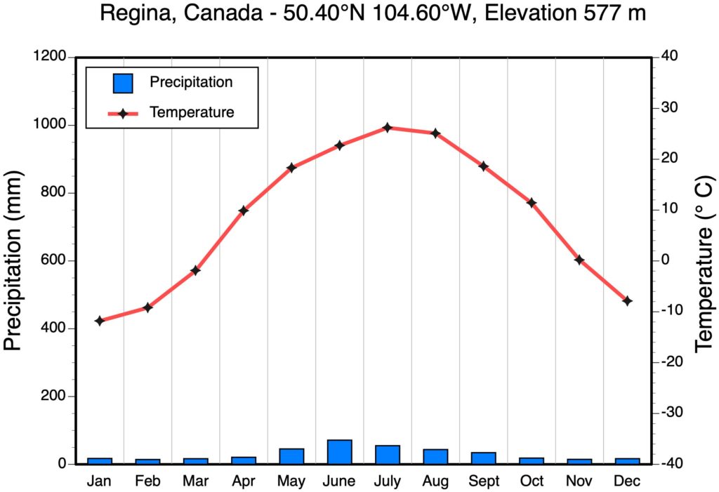
2.1) What is Regina’s Köppen Climate Classification?
2.2) Explain the wide range of average monthly temperatures found here.
QUESTION 3
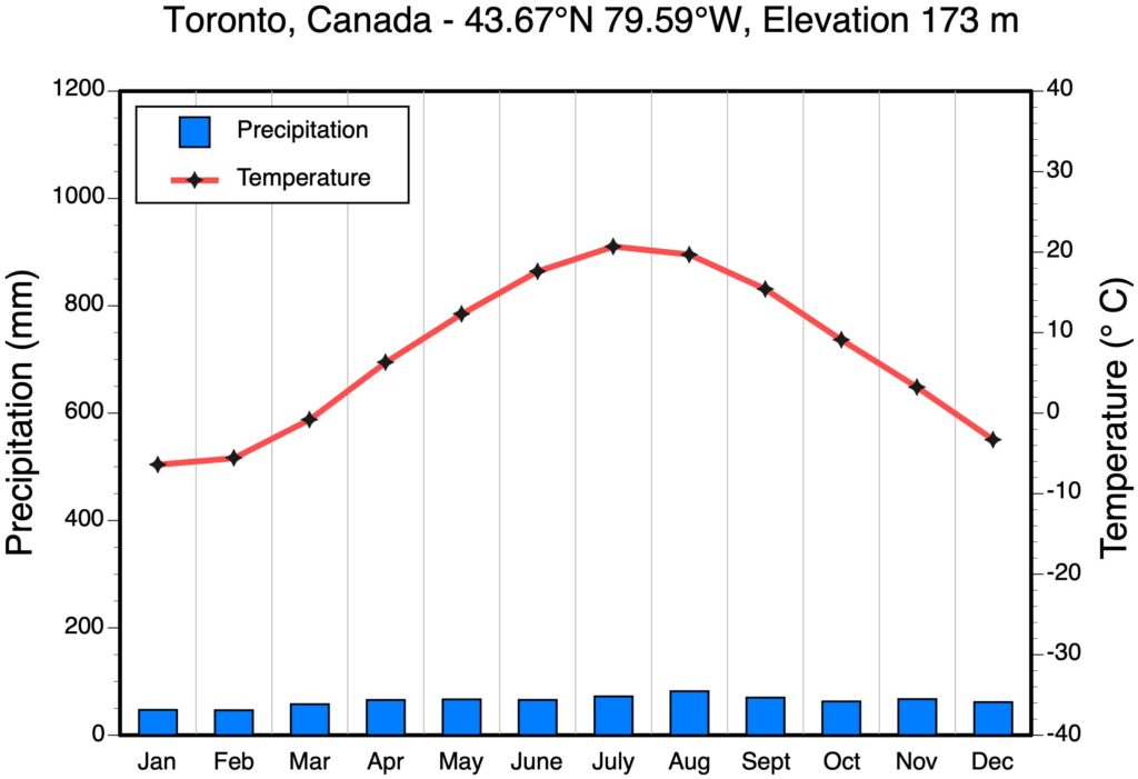
3.1) Toronto’s Köppen Climate Classification?
3.2) What climate factors are responsible for summer (June, July, and August) precipitation in Toronto? (Multiple answers are accepted for this question)
A Monsoons.
B Intertropical Convergence Zone.
C Mid-latitude Cyclones.
D Thunderstorms.
3.3) What climate factors are responsible for winter (December, January, and February) precipitation in Toronto?
A Monsoons.
B Intertropical Convergence Zone.
C Mid-latitude Cyclones.
D Thunderstorms.
QUESTION 4
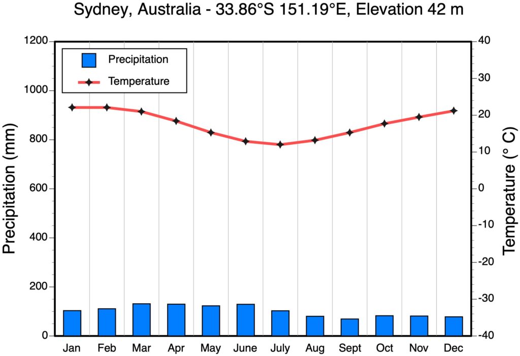
4.1) What is Sydney’s Köppen Climate Classification?
4.2) How can we tell from the graph that this location is in the Southern Hemisphere?
4.3) Explain why average monthly temperatures do not vary much throughout the year.
QUESTION 5
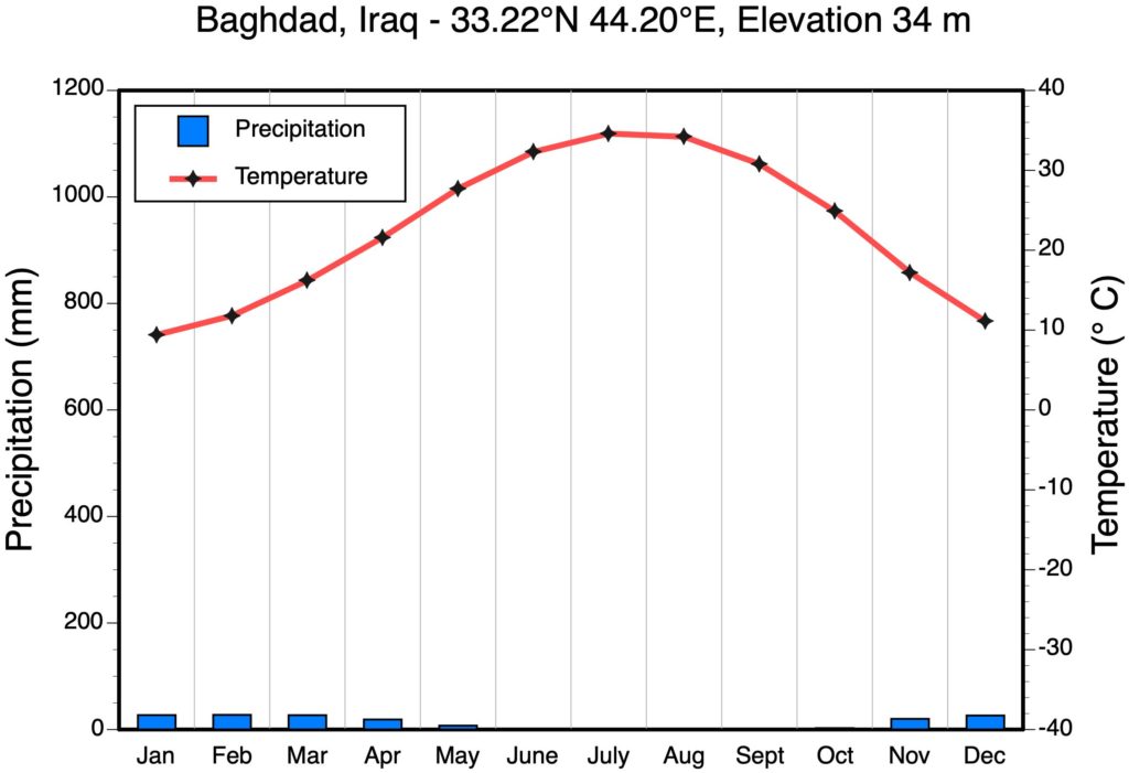
5.1) What is Baghdad’s Köppen Climate Classification?
5.2) Why is it so arid in Baghdad? Is Baghdad a subtropical or mid-latitude desert?
5.3) Which climate factor is responsible for the winter precipitation that falls here?
A Monsoons.
B Intertropical Convergence Zone.
C Mid-latitude Cyclones.
D Hurricanes.
QUESTION 6
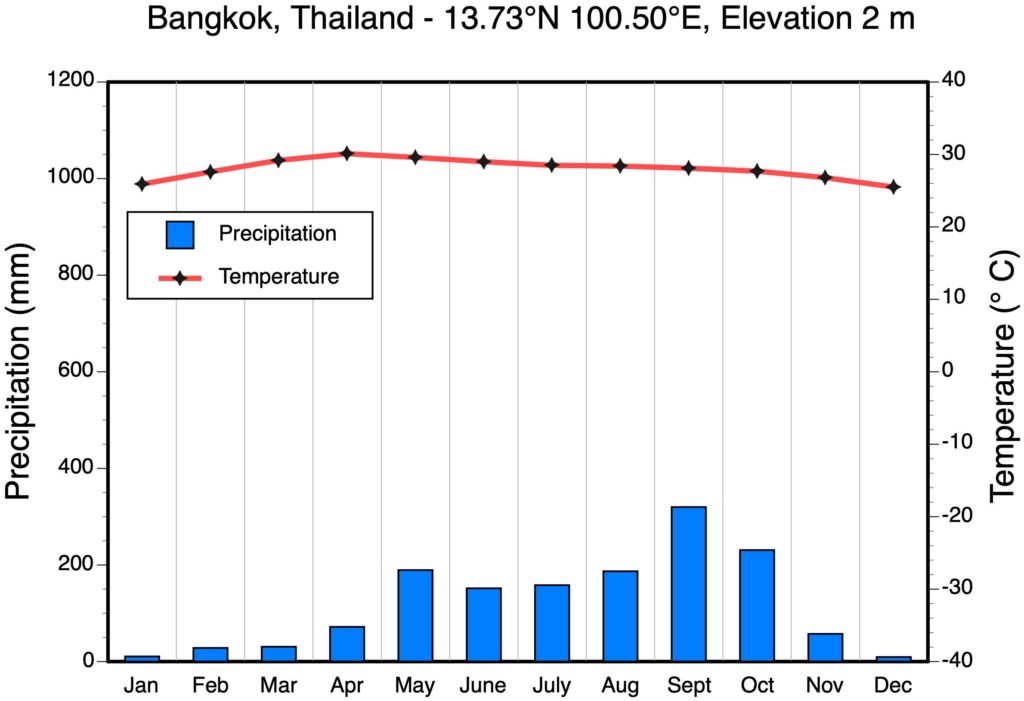
6.1) What is Bangkok’s Köppen Climate Classification?
6.2) Which climate factor is responsible for the May to October precipitation that falls here? (Multiple answers are accepted for this question)
A Monsoons.
B Intertropical Convergence Zone.
C Mid-latitude Cyclones.
D Thunderstorms.
QUESTION 7
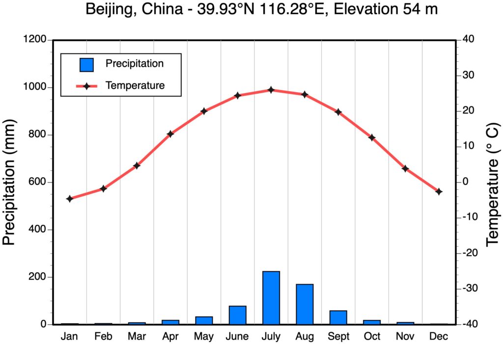
7.1) What is Beijing’s Köppen Climate Classification?
QUESTION 8
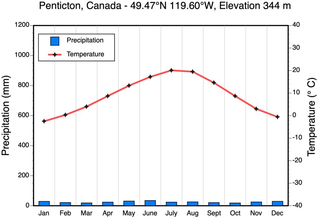
8.1) What is Penticton’s Köppen Climate Classification?
8.2) Why is it so arid (dry) in Penticton?
QUESTION 9
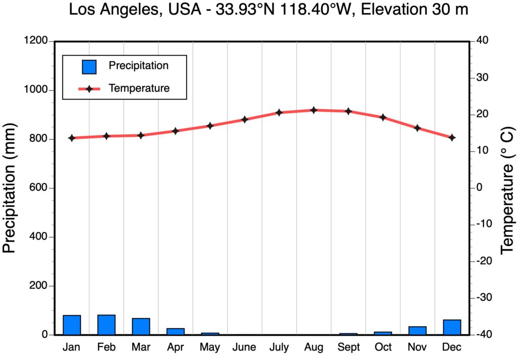
9.1) What is the Köppen Climate Classification of Los Angeles?
9.2) Which climate factor is responsible for the November to April precipitation that falls here?
A Monsoons.
B Intertropical Convergence Zone.
C Mid-latitude Cyclones.
D Thunderstorms.
QUESTION 10
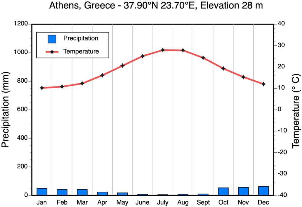
10.1) What is the Köppen Climate Classification of Athens?
10.2) What location already examined has a similar climate to Athens? (HINT: it might not have exactly the same classification.)
QUESTION 11

11.1) What is Yellowknife’s Köppen Climate Classification?
11.2) Which climate factor is responsible for the July to October precipitation that falls here?
A Monsoons.
B Intertropical Convergence Zone.
C Mid-latitude Cyclones.
D Thunderstorms.
11.3) Why is Yellowknife so cold in the winter? What air mass dominates this location in winter?
QUESTION 12
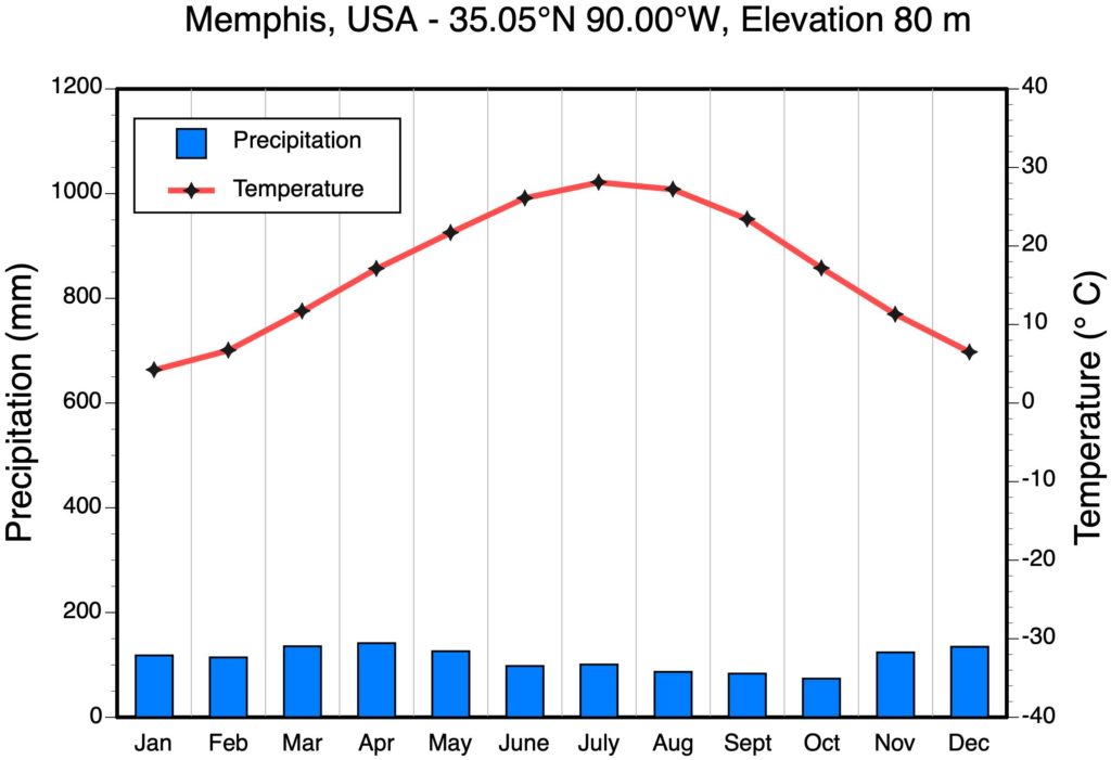
12.1) What is the Köppen Climate Classification of Memphis?
12.2) Which climate factor is primarily responsible for the summer (June to August) precipitation that falls here?
A Monsoons.
B Intertropical Convergence Zone.
C Mid-latitude Cyclones.
D Thunderstorms.
12.3) Which climate factor is primarily responsible for the winter (December to February) precipitation that falls here?
A Monsoons.
B Intertropical Convergence Zone.
C Mid-latitude Cyclones.
D Thunderstorms.
QUESTION 13
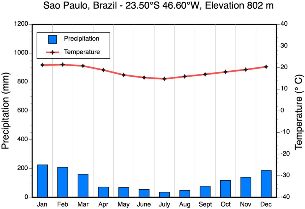
13.1) What is the Köppen Climate Classification of Sao Paulo?
13.2) Which climate factor is responsible for the October to March precipitation that falls here?
A Monsoons.
B Intertropical Convergence Zone and thunderstorms.
C Mid-latitude Cyclones.
D Hurricanes.
13.3) Why does precipitation decreases from April to September?
QUESTION 14
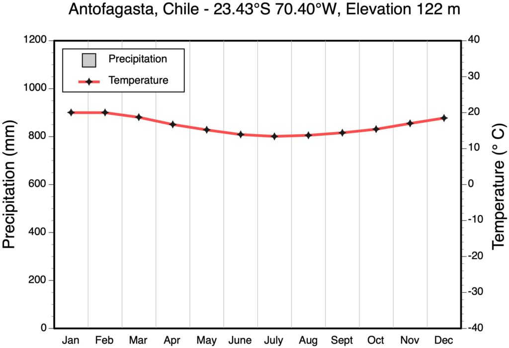
14.1) What is the Köppen Climate Classification of Antofagasta?
14.2) Why is there a lack of precipitation all year long?
QUESTION 15
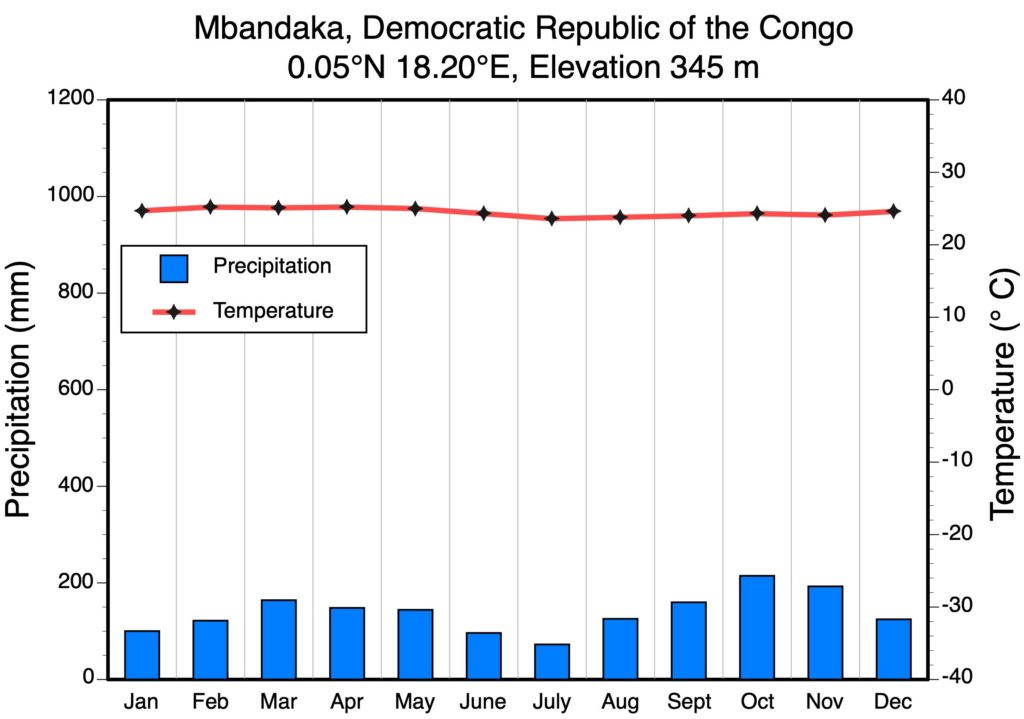
15.1) What is the Köppen Climate Classification of Mbandaka?
15.2) Why is there so little variation in average monthly temperature at this location?
15.3) Why are the average monthly temperatures so high at this location?
QUESTION 16
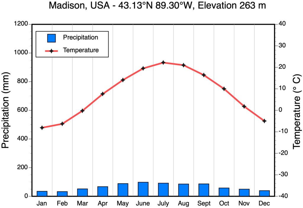
16.1) What is the Köppen Climate Classification of Madison?
16.2) Which climate factor is primarily responsible for the summer (June to August) precipitation that falls here?
A Monsoons.
B Intertropical Convergence Zone.
C Mid-latitude Cyclones.
D Thunderstorms.
16.3) Which climate factor is primarily responsible for the winter (December to February) precipitation that falls here?
A Monsoons.
B Intertropical Convergence Zone.
C Mid-latitude Cyclones.
D Thunderstorms.
IMAGE CREDITS
All Climograph Images Copyright Michael Pidwirny.
QUESTION ANSWER SHEET
FIGURES AND TABLES – PDF FILES
Lab 5 Koppen Classification Guide
This Laboratory Exercise is Licensed Under Attribution-NonCommercial-NoDerivatives 4.0 International (CC BY-NC-ND 4.0).
Updated April 4, 2021
A storm that typically ranges in size from several kilometers (several miles) to over 50 kilometers (30 miles) in diameter created by the quick lifting of moist warm air which creates a cumulonimbus cloud. Thunderstorms can occur in isolation as a single celled storm or as a multi-celled storm arranged in a cluster or as a line of adjacent cells (called a squall line) found along or ahead of a mid-latitude cyclone cold front. Thunderstorms can have the following severe weather associated with them: strong winds; hail; lightning; tornadoes; thunder; and heavy rain.
Zone of low atmospheric pressure and ascending air located at or near the equator. The rising air currents at the ITCZ are the result of global wind convergence and convection from thermal heating. The ITCZ generally has the same geographic location as the thermal equator.
The forced uplift of an air mass because of the presence of a topographic obstruction. This uplift also causes the cooling of the air mass. If enough cooling occurs condensation can occur and form into orographic precipitation. Also called orographic lifting.
An extensive region of surface atmospheric high pressure located at about 30° North and South latitude. These high pressure systems produced by vertically descending air currents from the Hadley Cell.
Combined loss of water to the atmosphere through the processes of evaporation and transpiration.
The tendency of terrestrial surfaces on Earth to experience more temperature variation than ocean surfaces. The main factor responsible for this fact is that the soil, sediment, and rock that makes up land has a lower specific heat than water.
The reduction of precipitation commonly found on the leeward side of a mountain. This reduction in precipitation is the result of compression warming of descending air.
Cyclonic storm that forms primarily in the middle latitudes. The formation of these storms is triggered by the development of troughs in the polar jet stream. These storms also contain warm, cold, and occluded fronts. Atmospheric pressure in their center can get as low as 970 millibars. Also called wave cyclones or frontal cyclones.
Air mass that forms over extensive ocean areas of the low latitudes. Around North America, these systems form over the Gulf of Mexico and the eastern tropical Pacific. Maritime Tropical air masses are warm and humid in both winter and summer. In the Northern Hemisphere, maritime tropical air masses can normally be stable during the whole year if they have form just west of a continent. If they form just east of a continent, these air masses will be unstable in both winter and summer. On weather maps, the symbol mT is used to identify a Maritime Tropical air mass.
Air mass that forms over extensive landmass areas of middle to high latitudes. In North America, these systems form over northern Canada. Continental Polar air masses are cold and very dry in the winter and cool and dry in the summer. These air masses are also atmospherically stable in all seasons. On weather maps, the symbol cP is used to identify a Continental Polar air mass.
Air mass that forms over extensive landmass areas in the high latitudes of the Northern Hemisphere. These air mass systems form only in winter over Greenland, northern Canada, northern Siberia, and the Arctic Basin. Continental Arctic air masses are very cold, extremely dry, and very stable. On weather maps, the symbol cA is used to identify a Continental Arctic air mass.
Air mass that forms over extensive landmass areas in the high latitudes of the Northern Hemisphere. These air mass systems form only in winter over Greenland, northern Canada, northern Siberia, and the Arctic Basin. Continental Arctic air masses are very cold, extremely dry, and very stable. On weather maps, the symbol cA is used to identify a Continental Arctic air mass.
Air mass that forms over the Antarctic landmass in the Southern Hemisphere. These air mass systems form during the entire year. Continental Antarctic air masses are very cold, extremely dry, and very stable. On weather maps, the symbol cAA is used to identify a Continental Antarctic air mass.
High pressure system located in the upper atmosphere at the polar regions. In this system, air in the upper troposphere moves into the vortex center and then descends to the Earth's surface to create the polar highs.
