Part I. Relative Time & Stratigraphy
Introduction
Earth scientists refer to both relative and the absolute time scales. A relative time scale simply tells you that one event or object is older or younger than another. For example, the fact that you were born after your mother fixes your relative ages. An absolute time scale fixes units of time to events or objects. If you were born in 1990 and your mother in 1965, then you are 25 years younger than your mother.
A set of stratigraphic principles were developed to reconstruct the relative order of geological events. By the 1800s, geoscientists had developed a relative time scale for many events in Earth history, but vigorously debated the absolute time required to account for them. They were not able to fix absolute ages to these events until the discovery of radioactivity and advent of radiometric dating in the early 1900s.
Stratigraphic Principles
Geoscientists use a number of principles to determine the relative timing of rocks and the events that formed and modified them:
1. Principle of Original Horizontality
Beds are usually deposited in a near-horizontal manner (there can be exceptions). Beds that dip or slope significantly have therefore been affected by tectonic forces.
2. Principle of Superposition
In any sequence of flat-lying strata, the oldest layers occur at the bottom and the youngest occur at the top of the sequence.
3. Principle of Lateral Continuity
Sedimentary layers can be traced laterally (sideways) in all directions for varying distances, making it possible to correlate rocks (infer that they are the same) between boreholes or localities. Exception: geological strata will not be laterally continuous if they:
-
- Gradually change in composition.
- Thin to nothing as you move laterally (also known as pinching out).
- End at an igneous intrusion.
4. Principle of Fossil Succession
Fossils, and assemblages of fossils, succeed (follow) one another up through a stratigraphic succession (and therefore through time) in a regular and determinable order. A fossil assemblage describes when a number of fossil species are found together in the same rocks, and the whole group together is a characteristic of that rock. We will be learning more about fossil assemblages and the principle of fossil succession in later labs.
5. Principle of Inclusions
Inclusions are pre-existing foreign rock or mineral fragments contained within (i.e., included) in a rock unit. Inclusions are older than the rock unit that contains them.
6. Principle of Cross-Cutting Relationships
When one rock unit is found cutting a second (only pertaining to igneous dykes and intrusions), the one doing the cutting is the younger of the two. The same applies for faulting. The fault must be younger than the material that is faulted. (You can’t cut a sandwich in half without the sandwich being there first.)
7. Walther’s Law
The vertical sequence of rocks mirrors the distribution of rocks commonly observed laterally. In other words, the horizontal gradations in depositional environments that you learned about in Lab 2 are repeated vertically as environmental conditions at a location change over time (for example, as sea level rises and falls). This applies when the rock record is continuous and has no gaps in time (see Unconformities below). This is covered in detail in Part II of this lab.
8. Unconformities
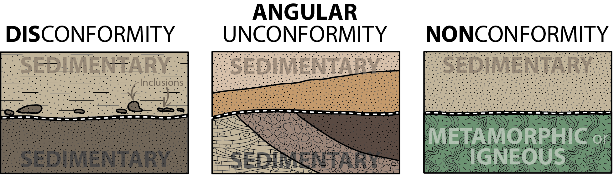
Unconformities are gaps in the rock record for which there is no evidence of sediment being deposited (white dashed lines in Figure 3.1). Certain geological conditions may create an environment in which no deposition occurred, leading to break (a hiatus) in the sediment record. Alternatively, the missing rock may have been deposited, but then eroded away. Both result in sediments “missing” from the rock record and therefore the rocks above and below the unconformity are not in direct time sequence. If the sedimentary beds above and below the hiatus are parallel to each other, the unconformity is called a disconformity (Figure 3.1, left).
If strata below the unconformity have been tilted or folded prior to erosion, then overlain by younger strata that may or may not be tilted relative to the unconformity, this is an angular unconformity (Figure 3.1, middle).
A nonconformity is a type of unconformity where the erosional surface is in an igneous or metamorphic rock that is overlain by sedimentary rock (Figure 3.1, right).
Unconformities are sometimes drawn in cross-sections or in stratigraphic logs using dark thick lines, or with wiggly lines. However, it may also be that they are not highlighted in any way, and must be identified by the relationships of the rocks.
Unconformities usually represent a large-scale event, in that the time “missing” is significant, and the lateral scale is large. For example, a surface representing a period of erosion lasting 10 million years caused by sea level change would be considered an unconformity. In contrast, erosion caused by a river flooding and partially eroding the surrounding river delta would not.
Geologic Cross-Sections
A geological cross-section presents the side view of a imaginary vertical slice cut from the ground. The information needed to construct a cross-section may only be available from a limited number of outcrops, or may be obtained from boreholes drilled to obtain stratigraphic information. The raw outcrop or borehole data is used to interpolate between locations using the stratigraphic principles above. You will construct cross-sections from raw geological data in Lab 4. For now, we will use ones that have already been made.