Lab 4. Stratigraphic Correlation
Printer-friendly worksheets for Lab 4 (Exercises 4.1-4.3)
Goals
By the end of this lab you will be able to:
- Understand the principles used to match stratigraphy from one location to another using rock type, fossil assemblage, or by similarity in time of deposition.
- Construct stratigraphic cross-sections like those you saw in Lab 3 using raw borehole stratigraphic data.
- Correlate stratigraphy from multiple locations and reconstruct changes in facies in both time and space.
Introduction
In Lab 4 you will use apply what you’ve learned in Labs 2 and 3 about facies and sea level change. Let’s review:
Lab 2: One Time, Different Environments
Lab 2 introduced the idea of sedimentary facies, which links specific depositional environments (like those in Figure 4.1) to the rocks that form from sediments deposited in those specific conditions. You looked at satellite photos of depositional environments in different landscapes to see how those environments were related in space, and then learned to connect that spatial distribution to the location of specific rock types.
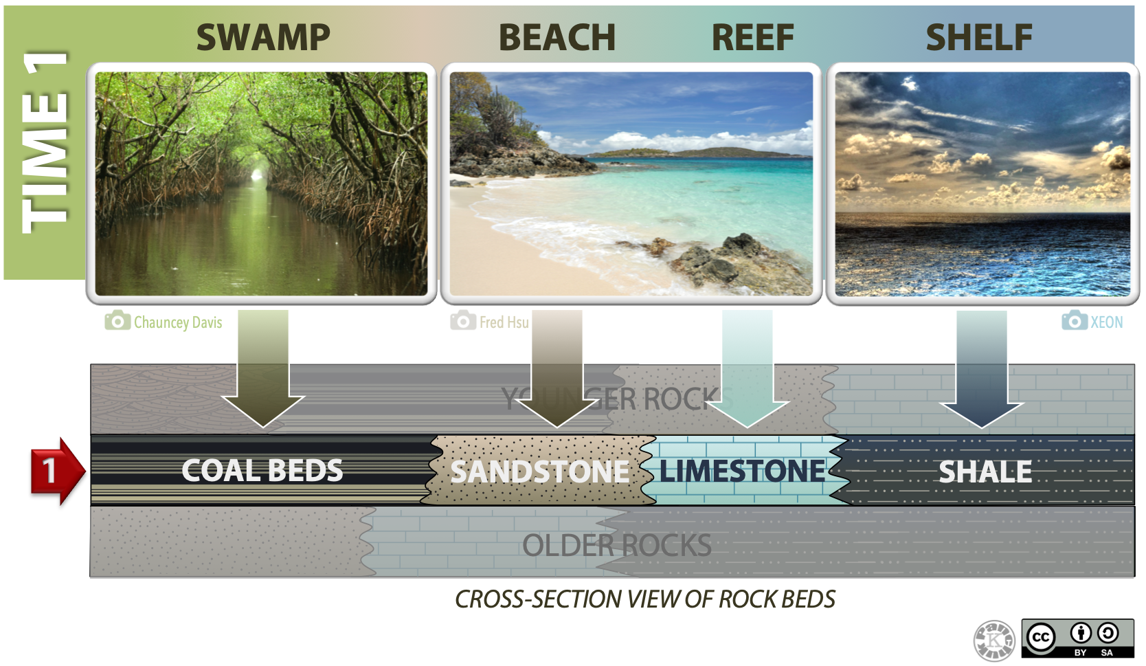
The environments in Figure 4.1 are arranged in the spatial sequence in which they would be present, from transitional on the left, to marine on the right. Imagine yourself going on a journey one day, and the images from left to right are the photos you take as you travel to the ocean. (Note: distances are not to scale.) If you took a time machine and travelled millions of years into the future, you could see a geological “snapshot” of your journey in the form of a lateral sequence of rock types representing environments that existed at that time (cross-section layer marked with the arrow), and capturing the special characteristics of each environment. The rock layers would be in the same spatial arrangement as the environments they correspond to.
Lab 3: One Location, Different Times, Different Environments
Lab 3 introduced the relative geological time, and the methods used to determine the time sequence of rocks relative to each other. You learned how to construct a sedimentary history from the rock record at one location (a stratigraphic log).
Lab 3 added the dimension of time to the lateral distribution of facies. You learned to recognize lateral changes in facies boundaries from the changes they created vertically at a single location. For example, if sea level is falling and moving further offshore, your observation location will change from being underwater to being a terrestrial location. The sediments deposited will change as well.
This is illustrated in Figure 4.2, where the environment at Time 1 is the same as the one in Figure 4.1, but we also see what the environment was like at an earlier time (Time 0) and a later time (Time 2). The red line and markers indicate the same geographic location as sea level falls from a high at Time 0 to a low at Time 2 (i.e., regression is happening). Depositional settings “slide” to the right, and this is recorded in the rocks that form from the sediments that accumulated at different time (see the cross-section at the bottom of Figure 4.2).
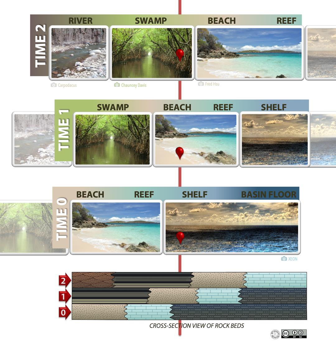
Figure 4.1 summarizes the progression from Labs 2 to 4. It follows an example of a sedimentary sequence deposited over three different time periods: Time 1, Time 2 and Time 3 (from oldest to youngest). The top of the figure shows a plan view (from above) of the area during Time2 and what we know about the spatial distribution of rock types. The bottom of the figure shows a cross section west-east across the middle of the plan view along the line from B to B’ from left to right. Refer to Figure 4.1 as you read the following paragraphs.
Lab 4: Reconstructing Different Times, Environments, & Locations
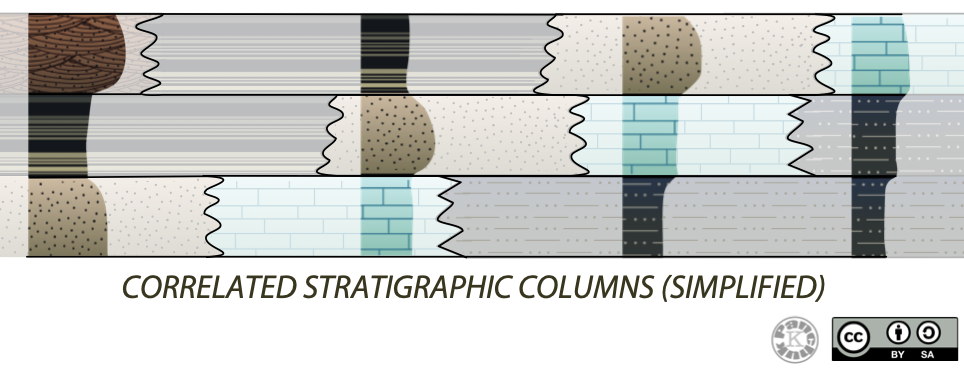
In this lab, you will use data from stratigraphic logs at multiple geographic locations to make a geological cross section. This is like being shown only a few segments of the cross-section in Figure 4.2, and deciding which beds are connected so you can reconstruct how the environments were related (Figure 4.3; note that this figure is highly simplified).
Geoscientists who study the history of Earth, seek hydrocarbons for the oil industry, or work in mineral exploration take things one step further. They would use observations at multiple locations to construct additional cross-sections and in additional orientations. They then bring the information in all those cross-sections together to reconstruct full plan views (map views) of the environment at multiple time periods.