Chapter 2 – Archaeology and Yukon’s First Peoples
Archaeological Sites of Significance
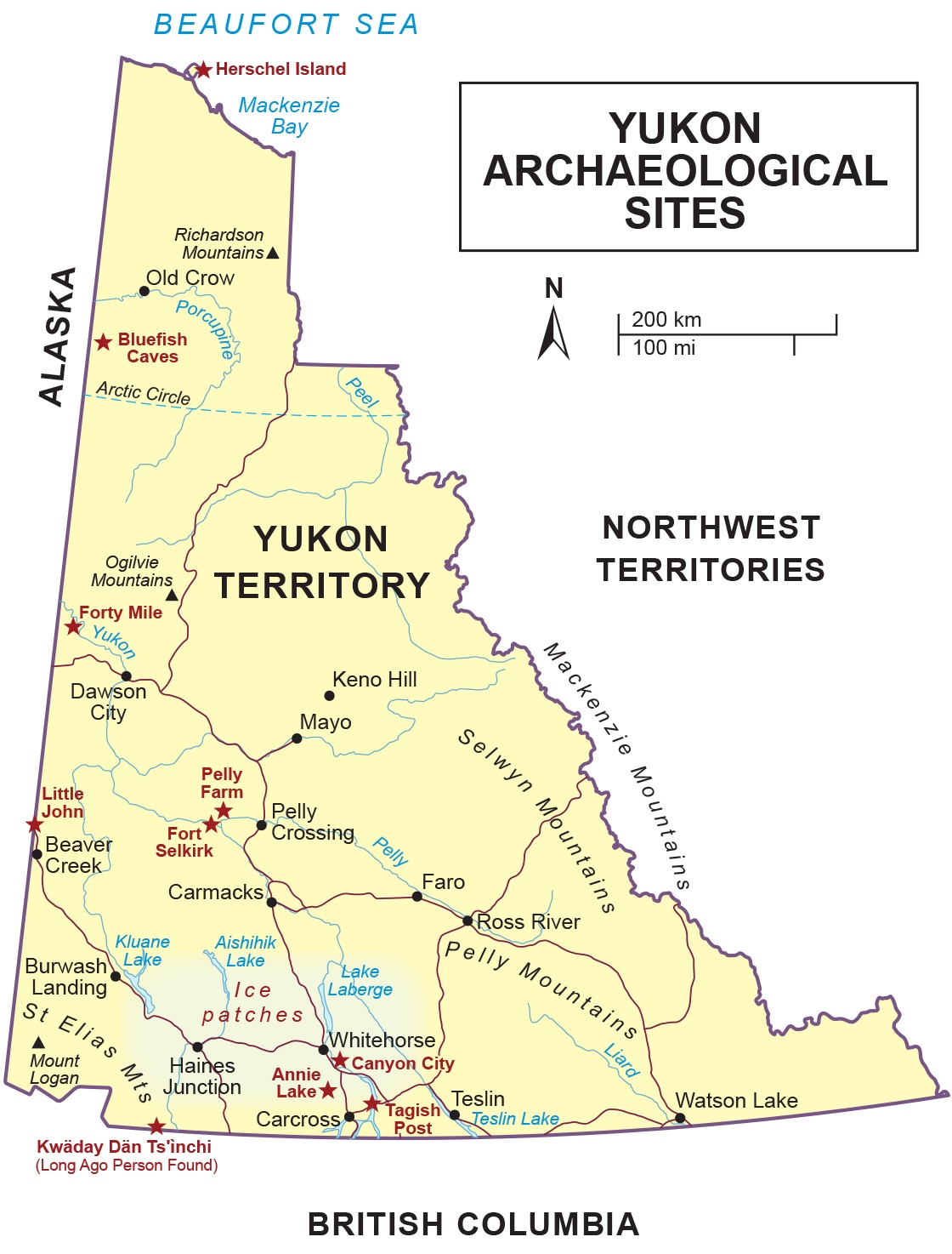
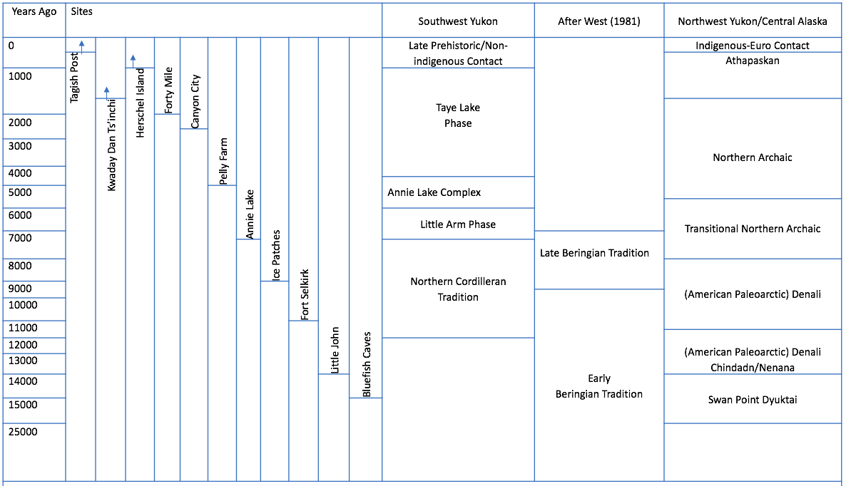
Before moving forward with a brief overview of some key archaeological sites that have been recorded in Yukon, it is worthwhile noting that there is still a great deal of disagreement within the archaeological community regarding terminology, dates, and archaeological traditions.[1] Figure 2.2 shows the archaeological sites discussed in this book. The following cultural historical sequence[2] (Figure 2.3) is by no means definitive; rather, it is a cursory sequence intended to help readers identify some of the more significant Yukon archaeological sites.
Earliest Sites
Bluefish Caves
Possibly the earliest site in Yukon is located in the northwestern portion of the territory. Bluefish Caves, 54 km southwest of the Vuntut Gwitchin First Nation village of Old Crow, overlooks the Bluefish River, a tributary of the Porcupine River (Cinq-Mars 1979; Morlan and Cinq-Mars 1982). These caves, located on the traditional territory of the Vuntut Gwitchin, contain evidence of three distinct periods. The earliest period is represented by small cobbles and pebbles as well as split long bones that may show traces of whittling and high polish, possibly man-made. One bone, a split caribou tibia,[3] dates to 24,800 years ago and may have been used as a fleshing tool used to process animal hides (Cinq-Mars and Morlan n.d. in Ackerman 1996:512–513; Bourgeon et al. 2017). A 23,500-year-old mammoth bone core and reattached flake may also indicate that people were making bone tools (Cinq-Mars in Morlan 1987:286). There are no associated stone (or lithic) artifacts found within the deepest layers, thus these remains may have been created by natural processes; this is still up for debate (Dixon 1999). Younger artifacts, which may be from a later period, have also been found at this site and include microblades[4], burins,[5] and debris—known as debitage in archaeology—left from the production of stone tools.
Little John
Another early site is the Little John site, which was excavated from 2002 to 2017 by Norman Easton (Figure 2.4). This site is located just off the Alaska Highway, 12 km north of the village of Beaver Creek, Yukon, and about 2 km from the international border with Alaska. This site, is within the traditional territory of the White River First Nation and unglaciated Beringia, and contains evidence of human occupation from the most recent past back to the end of the Pleistocene (10,000 years ago). The deepest identified site layer represents what may be the earliest precisely dated tool collection found in Canada. The tools found in that layer include bifaces, scrapers, large blades, and tear-drop–shaped Chindadn projectile points, two of which are dated to 13,200 years ago, while many of the rest are characteristic of this early time period. Subsequent layers also have evidence of human occupation ranging in time from after the Pleistocene to the present. In addition, excavations in 2008 uncovered bison and wapiti bones that had been modified by people. These modified bones were found in association with stone flakes and cores dating to 14,000 years ago (Easton et al. 2011:289). The Little John site represents a sequence of shifting lifeways over time, the movement of people and/or artifacts, and expressions of cultural identity through artifact remains (Easton and MacKay 2008).
Annie Lake
Located in the south-central Yukon, the Annie Lake site is in the Southern Lakes District and lies in the traditional territory of the Carcross/Tagish and Kwanlin Dün First Nations. This site contains evidence of occupation spanning from 7,200 years ago to the present day and is one of the older documented archaeological sites in Yukon. The site was originally discovered and excavated by Sheila Greer in the 1980s; Greg Hare continued excavations at the site in the 1990s (Greer 1981, 1982, 1983; Hare 1995; Hare and Greer 1994). The earliest layers showing human occupation of the site occur during a time when shrubs and forest were just becoming established again, as the glaciers began retreating and caribou and bison started to become plentiful. The site contains well-made projectile points constructed with high-quality materials. This site also contains a distinctive tool form called a lanceolate spear point, which is similar to points found in the Plains and Plateau regions and may represent cultural interaction between different groups. A large scallop shell is evidence of transport with coastal peoples during the past 1,000 years.
Ice Patches
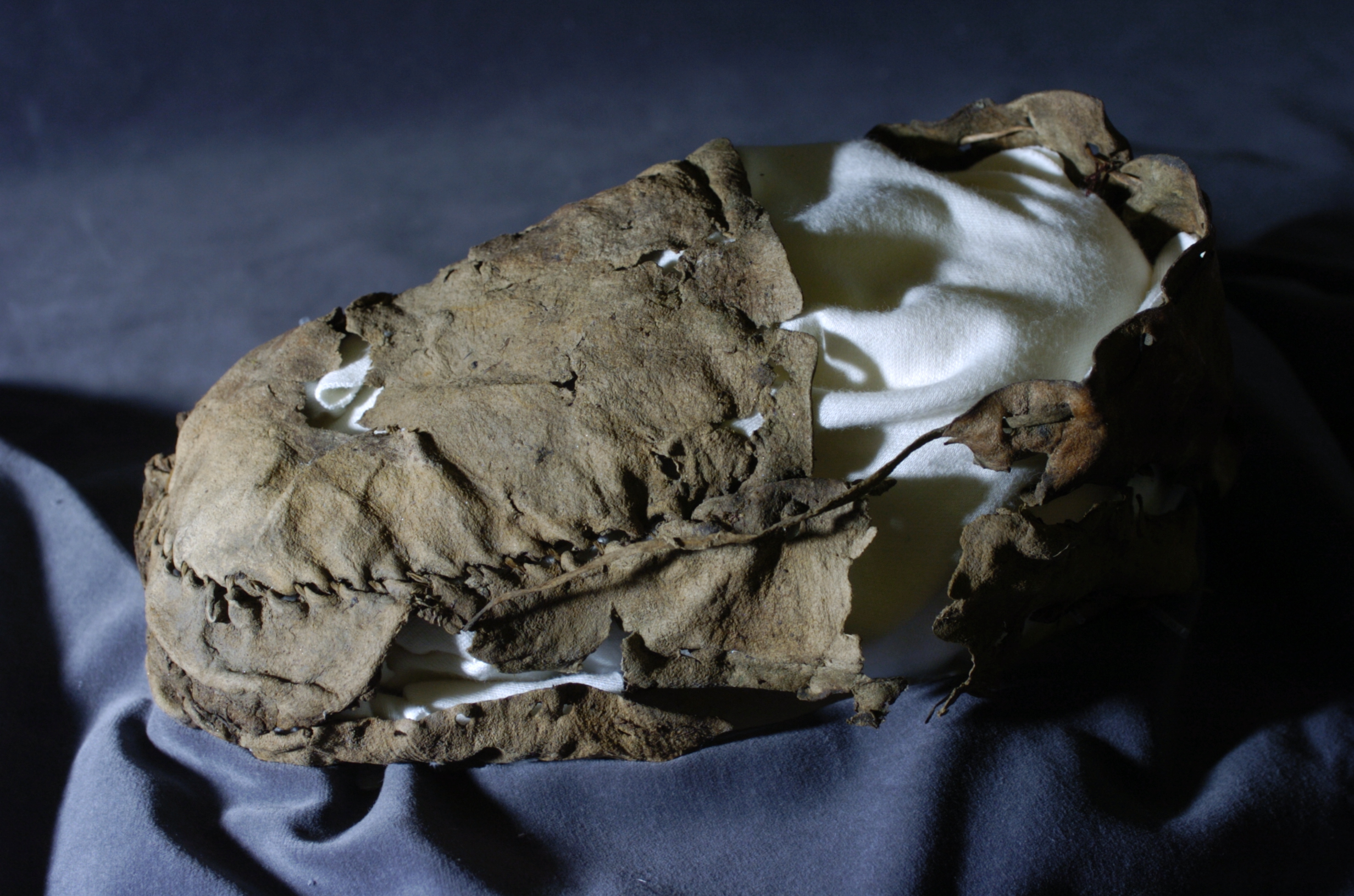
In 1997, two sheep hunters walking on the ice-covered peaks around Kusawa Lake in the southern Yukon discovered a wooden stick with string attached to it resting on an enormous pile of caribou dung. Yukon government archaeologists identified the string as sinew and also discovered some feathers attached to the stick. The dung and stick (which ended up being an atlatl[6] dart shaft) were dated to 2,400 and 4,300 years old (Hare 2011:6). The discovery prompted more research in what became known as the Ice Patch Project. There are currently sixteen Ice Patch sites identified on various mountaintops. These sites are located on the traditional territories of the Champagne and Aishihik First Nations, Kluane First Nation, Kwanlin Dün First Nation, Ta’an Kwäch’än Council, and the Teslin Tlingit Council. Some of the more significant archaeological finds include an ancient moccasin found in the Ruby Range that is approximately 1,400 years old, the oldest known moccasin in Canada (Figure 2.6) (Hare 2011:18). As well, there are approximately 200 artifacts made of bone, antler, wood, and stone, all of which are extraordinarily well preserved. The oldest artifact, a dart found west of Aishihik Lake, is 9,000 years old (Greer and Strand 2012:146-147; Hare 2011:22).
Anthropologists in Yukon and Their Collaborators: Norman Easton and Chief David Johnny
Norman Alexander Easton is a Canadian anthropologist. He has been an anthropology lecturer at Yukon University (formerly Yukon College) in Whitehorse since 1986. His research focuses on the social history of Northern Athapaskan (Déne) Indigenous people and prehistoric underwater archaeology. His current research activities in Yukon include projects in archaeology, social history, linguistics, and contemporary social issues. A large component of his research concentrates on the Little John site (discussed in this chapter). Norman was born in Vancouver and moved to Yukon by happenstance in 1986 when his wife found work there. He had just finished his master’s degree in underwater archaeology at the University of Victoria. While attending a Yukon Underwater Diving Association (YUDA) general meeting, he offered to take part in a project conducting an archaeological survey of the Yukon River system. This survey, conducted from 1986 to 1989 as part of YUDA’s Underwater Heritage program, was the first of three major research highlights of Norman’s northern archaeology career.
The second highlight was working on the Fort Selkirk Culture History Project from 1987 to 1991 in collaboration with the Selkirk First Nation and archaeologist Dr. Ruth Gotthardt. This was the beginning of Norman’s collaborative work with First Nations. The third highlight of his career has been working on the Yukon-Alaska borderlands since 1990 and discovering the different sites that are located there, including the site of Little John.
Norman graduated from university in the 1980s, a time when young anthropologists were starting to try different types of research, particularly through community involvement. He began conducting ethnographic and linguistic research with the White River First Nation of Beaver Creek, and Native Alaskans in Northway, Tanacross, and Tetlin, but did not conduct archaeological projects until his fifth year of research. That allowed him to establish rapport and trust with people in White River. This long-term community research has resulted in people throughout the Upper Tanana Valley region on both sides of the border feeling comfortable enough with Norman to share their time with his field school students, and to teach them about subsistence pursuits, such as hunting and fishing. He believes there is great value in having his students, many of whom are urban dwellers, leave the field school with a real appreciation of the value and importance of a village subsistence lifestyle. To Norman, collaboration means being patient and willing to put in the time to come back year after year, establishing personal relationships, not just professional ones. He feels that this is what counts with villagers: you need to be committed for the long term. What comes out of that is something really great that goes in all different directions. People will have a sense of real trust and they will know that the researcher cares about the people and their culture. It should not be about working with people for two weeks never to return. He feels you also have to be willing to be a part of the community.
What Norman loves most about Yukon are the people he has met in the course of his work that have taught him about the Déne way—the values that the Déne people hold. He has tried to integrate these values into his life and feels that he would not be the person that he is today without the guidance and support of Déne people.

David Johnny Senior is a former Chief of White River First Nation of Beaver Creek, Yukon. He has collaborated with Norm (Norman) Easton on archaeology and culture history projects for over 20 years. It took some time before their collaboration started. When Norm first arrived in Beaver Creek to begin his research on the borderlands at the invitation of Bessie John, David’s older sister and village matriarch, many in the community, including David, were not convinced that collaboration could happen. “You know,” says David, “you have government people coming up. They dig this site or that site but they never tell the First Nation nothing. When I became chief way back when, and Norm came and said he wanted dig, everybody was waiting for him to make a move. It took a few years but he came back and stayed with us.” In 1996, Bessie John adopted Norm with a traditional potlatch. This means Norm is now David’s nephew. “He stayed with my brother and he learned our ways. He learned our language, he learned by walking in our country. It took a few years to do that.”
Eventually, when Norm asked for permission to conduct archaeological excavations at Little John in 2002, the community told him he could but that he would have to get approval in the traditional way from Elders in Beaver Creek and Northway, Alaska. With their approval, Norm began bringing students from southern Canada, the United States, and Europe to excavate the site and learn about the cultural traditions of White River peoples. Graduate students would conduct their research and others would participate in the field school he put on every summer until 2016. Part of the student’s curriculum included Upper Tanana language lessons and listening to White River traditional stories as told by community members. David encouraged students to participate in moose cutting, packing, and cooking (including eating moose guts, moose head soup, and tongue, all delicacies).
Community members participating in the field school created some long-lasting friendships. David notes, “Still today, a lot of them call us, talk to us. A couple of them had kids and when we see them the kids say, ‘hi grandma, hi grandpa’. It came to the point where we interacted with them so much that a lot of them came into our family.” The community also supported student’s research by providing feedback on research publications.
For David, one of the highlights of working with Norm is his willingness to “put his side away, he took our side. He dressed like us, he talked like us, and he started thinking like us. We have a different way of thinking when it comes to digging up your ancestors [material culture]. It took a few years for us to get easy with that. For thousands of years we’ve had that tradition. We showed him our way and he accepted it and in turn taught us about archaeology.” Having Norm teach White River youth about their deep-time culture in a different way is also valuable. “Before it was Injii [forbidden], you can’t touch that stuff, but now just a simple rock draws their attention if it has a different shape.” David adds that, “before, nobody took the time to say, ‘here is my grandmother or great-great-grandfather, from 15,000 years ago.” He believes that learning through archaeology allows people to understand themselves better.
When asked what his favourite part of being from and living in Yukon is he says, “I would say the Little John site because we always had a hunting camp there. My dad said that people use to camp there a long time ago. It never really dawned on us. We thought about it and [back in the Pleistocene] there’s no trees, a big valley there and the animals travel up and down the valley. That’s when we looked at it from another way.”
Pelly Farm
The Pelly Farm site is located in the traditional territory of the Selkirk First Nation, on the north bank of the Pelly River approximately 5 km from its confluence with the Yukon River. The site, discovered in 1957 by Scott MacNeish, sits on an 18-metre-high terrace overlooking Pelly Farm (MacNeish 1964:220). Excavations uncovered a collection of stone tools and animal bones related to multiple occupations ranging from 5,000 years ago to until approximately 1,200 years ago. The deepest layers, showing the oldest human occupations, contained evidence of a small group of hunters who were processing bison and elk during the winter and muskoxen, bison, elk, caribou, bear, beavers, and birds during the summer. Over time, different people arrived and deposited their animal processing remains at the site. The final occupancy of the site indicates that people had new tools and were processing animals such as moose, caribou, goat, sheep, and rabbits. The numerous stone tools recovered include spear points, scrapers, choppers, burins, and hammerstones, indicating that people occupied this location multiple times over many years (MacNeish 1964:229–230).
A Change in Environment: White River Ash
Approximately 1,900 years ago and then again 1,250 years ago, massive volcanic eruptions occurred at Mt. Churchill, located in eastern Alaska close to the Yukon border. The second eruption was incredibly large and filled the air with plumes of volcanic ash, which spread eastward through Yukon to the Northwest Territories and beyond. Ingesting the ash would have seriously injured the eyes and lungs of animals and people—inhaling it would have been like inhaling particles of glass. Once the clouds settled, most of the central Yukon was covered with a substantial amount of volcanic ash. (This layer of ash is called White River Ash because its thickest deposits and first description are from along the White River.) Water sources would have become contaminated and vegetation would have been destroyed. Digesting the ash would have been akin to eating small shards of glass. No one is sure when plants and animals returned. What is visible archaeologically is the change in tool types that took place after the eruption (Clague et al. 1995:1177; Lerbekmo et al. 1975:203–209).
The fifteen hundred years after the eruption brought about notable innovations in technology and tool manufacture. Items made of copper appeared for the first time. Nuggets of native copper were heated and hammered into tools, including awls and arrow points, and adornments such as tinkling cones began appearing. As well, there was a greater prevalence of bone and antler tools. Some of these items often contained line and dot decorative motifs. Interestingly, this is a time when small stemmed and notched arrow points appeared in the tool kit, indicating a transition from the use of the atlatl to bow and arrow, a completely new technology. In interviews with Upper Tanana Elders, Mr. Andy Frank and Mrs. Bessie John (interviewed in Northway Alaska, August 2004), and Mr. Joseph Tommy Johnny (interviewed in Tsoogot Mann, July 2001), Norm Easton was told that the traditional village of Leek’ath Niik (Muddy Water Creek), which is located on the eastern side of the middle of Scottie Creek valley, “was the location to which their ancestors retreated at the time of the eruption and subsequent ash fall – a time referred to in their oral history as the year of two winters” (Easton 2009:17).
Later Sites
Fort Selkirk
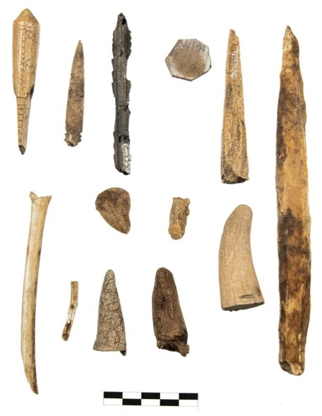
The late pre-contact and early contact period in Yukon is represented by a number of prominent archaeological sites. Fort Selkirk and the surrounding locality are situated on the confluence of the Pelly and Yukon rivers in the central Yukon and are part of Selkirk First Nation settlement land. The oldest evidence of occupation of this locality is an 11,300-year-old tool made from caribou antler. Local inhabitants have used the area as a seasonal fishing village and trading site for thousands of years. In 1848, Robert Campbell opened the first Hudson’s Bay Company (HBC) fur-trade post in Yukon across the river from the fishing village. His intent was to conduct trade with the Northern Tutchone people who had access to a significant quantity and variety of furs, such as beaver and marten. Campbell and his crew were the first non-Indigenous people that the Northern Tutchone had ever met. In 1852, the Coastal Chilkat Tlingit raided the fort, permanently ejecting the HBC fur traders from the post, because they wanted to maintain their fur-trade monopoly with the Selkirk people. The first archaeological testing of the site occurred in the late 1980s. At that time exposed chimney remains and a log-lined cellar were discovered. Additional excavations in the 2000s exposed the original fur-trade post, including wooden foundation beams, a large wood-lined cellar, and typical fur-trade post artifacts such as blue-on-white transfer print ceramics, trade beads, glass medicine bottles, cut copper sheets, metal buttons, and square cut nails. Interestingly, the site also contained a small number of Indigenous-use artifacts such as a bird blunt,[7] beamers,[8] barbed bone points,[9] and lithic and copper tools (Figure 2.7). Many of these artifacts were found within living quarters and may indicate developing social interactions between the Northern Tutchone and the HBC (Easton and Gotthardt 1987; Castillo 2012a).
 |
 |
 |
 |
| Figure 2.7 Fort Selkirk contact-period artifacts (Castillo 2012:119, 123, 142, 147). | |
Forty Mile
Beginning in 1988, the Tr’ondëk Hwëch’in First Nation and Yukon government conducted multi-year excavations at the Forty Mile site, which is located on Tr’ondëk Hwëch’in settlement lands at the confluence of the Yukon and Fortymile rivers in the northwestern Yukon. The site was tested in the 1990s to identify the location of archaeological evidence, and subsequent excavations between 2000 and 2005 resulted in evidence of periodic site use over thousands of years. These excavations uncovered artifacts and broken-down building structures of an early gold rush town (c. 1886), including Fort Cudahy, Fort Constantine (Northwest Mounted Police detachment), Forty Mile town, and Forty Mile Island. Artifacts and features included hearths with burnt bones still present, “triangular-shaped end scrapers, a bone point, a flaked-stone axe or wedge, birch bark and wood remains, and a small amount of stone debris from tool making” (Hammer and Thomas 2006:20). There is also evidence of bone and antler tools, the use of “copper working using small native copper nuggets, and the adoption of the bow and arrow” (Hammer and Thomas 2006:21). The site also demonstrates the importance of fishing and caribou hunting by the Hän people (Hammer and Thomas 2006).
Kwädąy Dän Ts’ìnchį
Kwädąy Dän Ts’ìnchį (Long Ago Person Found in Southern Tutchone) was an Indigenous man whose remains were found in 1999 in Tatshenshini-Alsek Park, British Columbia.[10] Using radiocarbon dating he is estimated to have lived during the “late pre-contact or Early European contact period ca. 1720 – 1850 cal AD” (Richards et al. 2017:118). His remains were well preserved, as were the tools and clothing he was travelling with. Through scientific analysis it was discovered that he was “a young man, essentially healthy, but also a carrier of a latent form of tuberculosis. He had eaten seafood much of his life and likely grew up close to salt water. He started his final journey in the late summer on or near the coast in the Haines-Klukwan area of Alaska and died only a few days later on the glacier” (Greer et al. 2017:571-572). Using “first-hand 19th century accounts, contemporary research and oral history from peoples of the area” (Champagne and Aishihik et al. 2017:201) researchers were able to begin to understand Kwädąy Dän Ts’ìnchį’s travel and lifeways as he followed a “variant of the western routing of the Chilkat Trail” possibly choosing this specific route because “the Dän, Tagish and Tlingit narratives of glacier travel indicate that glaciers were known as effective travel routes…” (Mathews et al. 2017: 481). His final destination may have been “one of the settlements on the Tatshenshini River or its tributaries (Champagne and Aishihik First Nation et al. 2017: 185). Through a community DNA study that included citizens from fifteen groups who had connections to the Tatshenshini-Alsek area, it was determined that 17 of 246 participants were related to him.[11] The project members who participated in this study considered it successful because of their reliance on different ways of knowing, which “included scientific studies involving scholars at many institutions, insights from old documentary sources and learning at the feet of knowledgeable First Nation elders” (Greer et al. 2017:572).
Archaeologists in Yukon and Their Collaborators: Dr. Raymond Le Blanc and Brandon Kyikavichik
Raymond (Ray) Le Blanc grew up just northwest of Toronto, in Rexdale (which is now a part of Etobicoke). Ray’s interest in archaeology was piqued at the age of 14 during a grade 11 history class at North Albion Collegiate Institute. The class partly focused on classical archaeology, which sparked in him a desire to learn more about archaeology, and he eventually discovered that there was more to the discipline than just the classics. He realized that there was a rich archaeological heritage in North America and, once he was accepted into the University of Toronto (U of T) as an undergrad, he dedicated himself to becoming an archaeologist.
After receiving his bachelor’s degree in archaeology from the U of T, Ray moved on to pursue a master’s degree at Memorial University. His thesis, titled “The Wigwam Brook Site and the Historic Beothuk Indians,” was completed in 1973. He returned to the U of T for his doctorate and cites Bill Irving, his dissertation supervisor, as one of his most influential mentors. In 1975, when Ray’s plan to work on Hudson’s Bay materials fell through, Bill invited him to join the Northern Yukon Research Program (NYRP) and go to Old Crow, Yukon, for the summer. As Ray says, “Once I got off the plane I realized I wasn’t going back to eastern North America.” He continued doing doctoral research in Old Crow for four years as part of the NYRP. It was during this time that he met Jacques Cinq-Mars, who was co-director of the NYRP with Bill Irving. It was Jacques who encouraged Ray to take on research at the Rat Indian Creek site, which is located 60 km upstream from Old Crow. The stratified site dates back to 2,500 years ago. Here he conducted major research on the development of the culture history in the Middle Porcupine area. And, during his years working with the NYRP, Ray also became familiar with many of the now well-known Yukon sites: Bluefish Caves, Dog Creek, K-Ridge, and the caribou fence sites of the northern Yukon. Ray has always made collaboration a key part of his work. To him, it isn’t collaboration so much as being a student, particularly when working with Indigenous Elders. For his doctorate, he was part of a multi-disciplinary research project that included people from Old Crow, both young people and Elders. He worked with community members Peter Tizya, Richard Charlie, Danny Kassi, Hugh Charlie, and Timothy Charlie. He also mentored younger archaeologists such as Sheila Greer and Ruth Gotthardt; Ruth was his field assistant in 1976 and 1977.
In 1979, Ray began working for the Archaeological Survey of Alberta. As Northern Archaeologist, he completed many major projects, including surveys of the Peace Country and Lesser Slave Lake, and excavated the Bezya microblade site in the oil-sands region. This work strongly resonates with northern Alberta researchers to this day. The lure of the North proved to be too strong, however, and after five years, Ray joined NOGAP—the Northern Oil and Gas Action Plan at the Archaeological Survey of Canada. As part of NOGAP, Ray again worked with Jacques Cinq-Mars on a number of important sites in the northern Yukon and in the Mackenzie Delta.
In 1983/1984, Ray completed his dissertation, The Rat Indian Creek Site and the Late Prehistoric Period in the Interior Northern Yukon (Le Blanc 1984). This work is one of the most solid discussions of the late prehistoric in Yukon and one of the first, and still most referenced, works on prehistoric antler and bone technology. In William Workman’s review of the dissertation monograph, he says that Ray “sets a new standard of rigour and detail… Le Blanc has made a valuable contribution to our understanding of a poorly known area… Certain of the analytical techniques break new ground and set new standards” (1987:189-191).
When NOGAP came to an end in 1991, Ray took up research and teaching duties at the University of Alberta (U of A), where he remained until his retirement in 2013. In 1994 he published the much-cited monograph The Crane Site and the Palaeoeskimo Period in the Western Canadian Arctic. In his review of this publication, Charles Arnold states, “Raymond Le Blanc’s research on the Crane site… significantly advances our understanding of the Palaeoeskimo period in the history of the western Canadian Actic… It is also an excellent example of how to carry out archaeological fieldwork, analyze and present data: it could be used in archaeological instruction as a model of a good report” (2010:104-105).
Ray supervised almost two dozen graduate students during his tenure at the U of A and taught courses in North American Prehistory, Cultural Resource Management, Lithic Technology, and Archaeological Methods, to name a few. He was also chair of the Department of Anthropology. In this period, he continued working in the northern Yukon independently and with his students, and at all times collaborating closely with the Vuntut Gwitchin community in Old Crow. The various sites he worked on included Rampart House, Schaeffer Creek, and Dechyoo Njik in Old Crow Flats, the moss houses at Berry Creek, and Rat Indian Creek, once again, where he researched the semi-subterranean house occupations. Beginning about 2005, Ray worked closely with the Vuntut Gwitchin Government Heritage Office as they began a long program of documenting their culture and history and places of importance in their traditional territory. Over a number of years, Ray worked with elders, community members and youth documenting caribou fences and archaeological localities and sharing his knowledge of the archaeology of the region acquired over many years. Other community members he has worked with include Lazarus Charlie, Charlie Thomas, Peter Tizya, Hugh Charlie, Danny Kassi, Joseph Bruce, Lance Nagwan, Chelsea Charlie and Brandon Kyikavichik. This work with the Vuntut Gwitchin continues to the present day. When asked what his favourite part of Yukon is he replies, “It’s being there. I enjoy the people and the environment, more the northern Yukon than anything else. I just love when I fly over there, I feel kind of enveloped in an area I know very well. I’ve actually had a fantastic opportunity to see so much of the country. I’ve had the privilege of being able to go into some pretty remote locations.”
Brandon Tyler Kyikavichik is a Vuntut Gwitchin culture and heritage specialist, and former Vuntut Gwitchin Chief and Council member. He was born in Whitehorse and raised in Old Crow, Yukon. Brandon became fascinated with his culture as a child. When he was twelve years old, he spent a few spring months in the bush with his grandfather who taught him about their history, language, and place names. That’s when he first became interested in heritage and culture.
Brandon first began working with Ray Le Blanc when he was in high school. He had gotten a job with the Vuntut Gwitchin Heritage Department when he was 15 years old. Every school year he would go and live in Whitehorse for high school and then in the summers he would return to work in heritage. He was asked to participate in a cultural technology camp which was meant to teach youth about the different “types of technology that Gwitchin people used to survive in an Arctic wilderness in ancient times before the advent of Europeans, when we were making everything from the land.” As an archaeologists with a focus on northwestern archaeology of the area, Ray Le Blanc was a facilitator during that project.
As Brandon explains it, “In the 1970s, Ray went around with an Elder named Lazarus Charlie, in Gwitchin his last name is Tetlichi. He went around to ancient sites with Lazarus, and they studied the archaeology of those sites, the human use of those sites together. Lazarus showed him where a lot of the old moss houses were and where the old underground cellars for storing meat, and fish, and berries were. We had all heard stories about the area from our Elders. It was called Dinizhoo. It’s a place where Gwitchin people used to gather and they would play games, and they would have events, and they would hunt and fish, and cook and work together. It’s right near a couple of caribou fences. It was an area that fell into disuse. For over a hundred years it hadn’t been used. But the Elders had heard many stories from their grandparents about the area. That’s where we did our cultural technology camp. Ray had been told about it by Elders, and he went there and found all kinds of amazing things. When he and I walked through the forest there we found dozens of huge underground cellars for storing meat and food and other things. He showed us old moss houses. I had heard all of those stories all of my life about how incredible our ancestors were and just being there the feeling was… inspiring doesn’t begin to explain the feeling when you’re there.” They also looked at caribou fences used to hunt caribou. “Decades later, after Ray had done a lot of studies around the Vuntut territory and had written a couple of books, he probably knew the most out of a lot of researchers so they brought him along [to the cultural technology camp].” Ray and some Vuntut Elders showed the youth the location of underground cellars, caribou and adze-cut trees (an axe-like tool used for cutting wood), stone tool replicas such as obsidian knives, bow and arrows and atlatls. Brandon says, “You know, it was pretty cool. And that was my first experience with Ray… Going to the caribou fences. It was my first time ever experiencing, seeing, actually being around the caribou fences, with Ray. That was a pretty amazing experience.”
One of the things Brandon is most proud of is his community’s ability to connect youth, adults and Elders during the culture camps. “We have youth there, we have young adults who help do a lot of the work, and they do a lot of the hunting and teaching as well. Then, you also have the Elders there for their stories and teachings. We add in the archaeologists and the technical help, the scientists, everyone working together. Everyone knows their role. There’s another level of inspiration that comes when you actually get out there and you see the proof of the evidence. The stories we hear growing up, the next thing you know you’re out there and you’re seeing the archaeologists and the people they’re working with finding evidence of these stories.”
Brandon also spent time with Ray visiting Gwiinzii Cave. In the Gwitchin language, this means good. He comments that Ray isn’t someone who likes to sit around. When they visited Gwiinzii Cave, Ray trekked up and down the mountain, a very steep mountain every day. “We were living on top of a mountain, in the summit, and we had to build a camp, chop and pack wood. Ray had some physical issues at the time but he was putting in 12 to 13 hours a day of strenuous labour.” Brandon enjoyed working with Ray because he was able to learn new skills, techniques, and methods.
Recently, Brandon has been working with his uncle Joe, writing the Gwitchin language, in the modern orthography. His uncle is one of the most fluent speakers of the Vuntut dialect. They listen to recordings of Elders that were made in the 1970s and 80s. Many of those Elders were born in the late 1800s. They transcribe the Elders words in Gwitchin and then translate that into English. Brandon and his uncle transcribed Elder Myra Kay Kyikavichiks story, and in that story she talked about the moss houses that Brandon had visited with Ray. She described how they were built and that they were meant for people who decided to settle down. “When you start to get to a certain age, you can’t really live that life anymore. The moss houses were close to a caribou fence and they were also close to a fishing area as well. Myra tells a story about two old women that got left behind. They were done with the chase, they were done with the migrating, and the moving and the nomadic lifestyle. And so the community built them two moss houses, one each. Then they built them a fish trap. They let them live by that fish trap in those moss houses and that’s where they stayed most likely. Those are pretty inspiring stories.”
When asked what his favourite part of living in Yukon is, Brandon responds, “Obviously, it’s going to be the wilderness. It’s beautiful. One of the things I’m lucky with up here is that I’m scholastically inclined. I can be academic and scientific at times. But, I grew up right here in Old Crow in the bush. I can do whatever I need to do on the land as well. There’s just nowhere else in the world where you can become such a well-rounded person.” Brandon’s favourite place is Old Crow. “I lived in Old Crow my whole life, it’s a difficult place to live, it’s such a harsh climate. But, there really is something inherently beautiful about this place and about the people that grew up here as well. I would have to say Old Crow.”
Tagish Post
The Northwest Mounted Police established Tagish Post in 1897 to deal with the influx of thousands of prospectors heading to the Klondike[12] gold rush (Dobrowolsky 1995). The post was located upstream of a major Tagish Indigenous village near the head of Marsh Lake in the southwestern part of Yukon. For the duration of the Klondike gold rush (see Chapter 4) Tagish Post was the only Canadian customs port for those entering the country via the White Pass, Chilkat, and Taku River trails. Many local Indigenous people worked as guides and packers assisting the southern gold seekers. The site was tested in the 1980s and 1990s (Greer 1981; Hare and Gotthardt, personal communication 2007), and archaeological excavations of the site were conducted in 2007 and 2008 (Castillo 2008, 2009). Twenty-nine building features, 22 garbage middens, and over 120 artifacts were identified and/or recovered at the site. Building features include the inspector’s quarters, the sergeant’s quarters, the hospital, and the detachment. Recovered artifacts include semi-synthetic leather, the butt of a gun, a horseshoe, a metal latch, complete medicine bottles, a key, and a round wooden container with a preserved salve still inside. Interestingly, although some Indigenous people earned part of their living here, there were no Indigenous artifacts recovered at Tagish Post.
Canyon City
Canyon City is an archaeological site located in the city of Whitehorse at Miles Canyon in the traditional territory of the Kwanlin Dün First Nation. The site was first excavated in 1994 and contained evidence of people living at Canyon City from 2,500 years ago until the year 1900. Originally the site was a summer gathering place for Indigenous people, and archaeological remains from this time include skin scrapers, flakes, and points, which indicate that hunting and fishing were conducted there. A foot trail following the Yukon River, traditionally used by people on their way from Marsh Lake to Lake Laberge and back, cuts through the site. The trail has not been dated but it was likely in use even during the early days of Indigenous occupation of the site. In 1897, a saloon was built at the site for the prospectors moving through on their way to the Klondike goldfields. A tramline was built a year later to move people’s goods through Miles Canyon. By the summer of 1898 a hotel, a restaurant, a store, stables, a machine shop, a Northwest Mounted Police post, and cabins and tents had been erected. Material remains from this time period include metal-working tools, household goods, beer and liquor bottle fragments, and thousands of food cans (Hammer and Hare 1999). With the establishment of the White Pass Railway Company in 1900, which moved people and goods from Skagway to Whitehorse, and the sale of the tramline to the aforementioned company, Canyon City was almost completely abandoned.
Herschel Island
Herschel Island (Qikiqtaryuk) is located off the northernmost part of Yukon on the Beaufort Sea, in the traditional territory of the Inuvialuit people. The island has a long history of occupation by Indigenous hunters, European whalers, the Northwest Mounted Police, and missionaries. This small island, measuring approximately 12 km in length, contains archaeological remains of the Thule culture dating back over 800 years ago and was occupied until the twentieth century. Archaeological excavations at Herschel were first conducted in the 1970s and 1980s near Pauline’s Cove, at a site called Washout. In the early 1990s, Max Friesen led an archaeological project as part of the Qikiqtaryuk Archaeology Project. Archaeological remains from these excavations included the discovery of three rectangular Thule houses. Hunting and fishing tools, sewing materials, evidence of skin preparation, and cooking implements, including pottery, were found within one of the houses. Animal bones, especially from ringed seals, and a large quantity of baleen from bowhead whales were also discovered, indicating their importance as a source of food and materials (Friesen 2012:146). Other early Herschel Island sites, such as Avadlek Spit, a long spit on the southwest side of the island, are also interesting for the lack of mammal bones and the abundance of fish and bird remains, which Friesen indicates is a rarity among Thule sites (Friesen 2012:149).
- The term tradition “refers to styles of artifacts, assemblages of tools or other items of material culture, architectural styles, economic practices, or artistic styles that last” over a long period of time (Darvill 2008:465–466). “The idea of a tradition implies a degree of cultural continuity even if there are local or regional patterns in the archaeological material” (Darvill 2008:466). ↵
- A cultural historical sequence is done by placing historical societies into distinct ethnic and cultural groupings according to their material culture or the objects they left behind. “The development of a robust culture history remains the object of some archaeological work, especially the geographical and chronological mapping of cultures and cultural influences” (Darvill 2008:118). ↵
- The tibia, or shinbone, is the larger and stronger of the two bones in the leg below the knee in vertebrates. It connects the knee with the talus, or ankle bone. ↵
- A microblade is a small, narrow stone blade, ranging from less than 5-11 mm wide and about 15-45 mm long. They were often made from a conical or wedge-shaped microcore, often punch-struck or pressure-flaked. ↵
- A burin is a “flake tool with a chisel edge that was produced by the removal of two flakes or spalls at right angles to one another to create a very fine sharp and durable edge” (Andrefsky 2005:254). It is “used for working bone, antler, and ivory and perhaps for engraving” (Darvill 2008:64). ↵
- Atlatl is an Aztec word for an early type of dart or spear thrower. An atlatl provided a means of increasing the thrust exerted on a spear or other projectile by artificially extending the length of the thrower’s arm and thus the leverage available (Darvill 2008:29). ↵
- A bird blunt is a bone or antler object used to stun birds (Emmons 1991: 138). One end of the shaft has a semi-rounded tip (Castillo 2012b:120). ↵
- A beamer is a split long bone, typically a caribou toe bone (metatarsal), which provides scraping edges. Beamers were used for hide tanning. People would remove the hair by scraping the skins or hides (Morlan 1973:300). ↵
- A barbed bone point is typically attached to a shaft and is thrown or shot at animals. The barbs keep the point in the animal. ↵
- This park is part of a UNESCO World Heritage Site, which also incorporates Kluane National Park in Yukon, and the Wrangell-St. Elias and Glacier Bay national parks in Alaska. ↵
- Participant groups included: Yakutat Tlingit Tribe, Chilkat Indian Tribe, Chilkoot Indian Association, Sealaska Heritage Inc., Kluane First Nation, White River First Nation, Carcross-Tagish First Nation, Kwanlin Dun First Nation, Ta’an Kwäch’än Council, Teslin Tlingit Council, Taku River Tlingit, Little Salmon-Carmacks First Nation, Selkirk First Nation, First Nation of Nacho Nyak Dun and Champagne and Aishihik First Nations (Greer et. al. 2017: 496). ↵
- The Klondike gold rush (1996-1899) was a time when there was a “massive influx of southerners into the Klondike area, Yukon, following news of the discovery of gold” (Dickason and Newbigging 2010:346). ↵
