Lab 12: Coastal Forest Virtual Field Trip
Nina Hewitt
British Columbia’s coastal forests are some of the most productive in the world. In particular, the mild rainy winters sustain the regional evergreen needleleaf (conifer) species that occur, and that attain truly goliath proportions over their long lifespans. Coastal forests sustain a species-rich biota ranging from tiny edaphic (soil) organisms, to mammals, birds, and understory plants. Several nations of Coast Salish peoples (including the Musqueum, Squamish, Tsleil-Waututh Nations) have lived sustainably in the region for millennia. Since European settlement, many coastal forests in the lower mainland region have been extensively logged and some converted completely to other human land uses.
This lab explores a large remnant of Coastal forest in Pacific Spirit Park [VIDEO], Point Grey, Vancouver, to examine its species composition, structure, and dynamics, particularly in relation to human and natural disturbance processes. A set of 360° photos and videos (one in 360°) will be used to demonstrate the local species and landscapes. At the end of the lab, you will have an appreciation for the main species present and the sorts of processes that affect coastal forest dynamics, both natural and human-caused.
Learning Objectives
After completion of this lab, you will be able to
- Become familiar with the species composition, structure and disturbance ecology of BC’s coastal forest ecosystems via an immersive digital experience.
- Use a dichotomous key to name and identify tree and shrub species present in coastal forests.
- Make field observations of forest stand structure and species composition and apply these to infer disturbance histories and predict future changes.
- Summarize some techniques for studying forests, including tree-ring dating (dendrochronology).
- Learn about and identify some of the woody invasive species that have been introduced into Vancouver’s Pacific Spirit Forest and other local ecosystems.
- Consider some of the forest management practices of Indigenous peoples in the region and how these practices contrast with those of modern settlers.
Pre-Readings
Forest Ecosystems, Ecological Disturbance, and Plant Succession
In order to complete this lab, some background information in forest ecosystems, plant succession, and disturbance processes is required. Consult your text and lecture materials to review background concepts of forest structure and dynamics, and concepts of ecological disturbance and succession. An overview is provided here.
Disturbance
Disturbance is a pervasive process in ecosystems. In the context of vegetation dynamics, it may be defined as any event that destroys part or all of the above-ground vegetation in an ecosystem. Disturbance includes wildfire, flooding, large-scale disease outbreaks, and major windstorms. Once viewed as a negative force acting on ecosystems, disturbance is now recognized as integral and essential to the function of many ecosystems. In forest ecosystems fire is often a critical disturbance. It has been a regular feature of BC’s dry interior ecosystems and even to some degree in the wetter coastal regions of this field trip. Fire-adapted species require regular, frequent fires to remove competition, prepare the soil for their seeds by removing litter and, for some conifers, provide the intense heat needed to open cones and release seeds. Without periodic fires, species in fire-prone ecosystems would gradually be replaced with less fire-adapted species.
For millennia in North America, wildfires were ignited by lightning or Indigenous peoples. However, European settlers engaged in fire suppression in many ecosystems for decades. Thanks to growing scientific evidence, land managers now recognize fire’s role and, over the last several decades, have begun to implement controlled or prescribed burns to restore this critical ecosystem process. Nevertheless, catastrophic fires have become increasingly frequent and intense in recent years due to a combination of factors, including previous fire suppression and buildup of dead wood that increases fuel loads, as well as hotter, drier conditions, and insect outbreaks associated with climate change. Although these newsworthy catastrophic fires have had tragic consequences for human populations, fire must be recognized as a critical ecosystem process in many systems, and considered in conservation and management agendas (Hewitt in Arbogast et al., 2018).
Plant Succession
Plant succession refers to gradual changes in plant community composition and structure that occur following large-scale disturbance (e.g., fire, logging, or cultivation) or on areas of new terrain (e.g., recently exposed glacial till, lava flows). Initial colonizing plant species are referred to as pioneer species. These are plants that arrive quickly via effective seed dispersal, or that are adapted to grow rapidly in the open, well-lit conditions of early succession. Other names for pioneer species include r-selected species or r-strategists, and early-successional species. They may contribute to the establishment of additional species via root penetration and the cycling of organic material and minerals in the soil, though their role may be less pivotal in facilitating subsequent plant populations than once assumed. Later in succession, additional plant species establish populations as their seeds arrive from neighbouring sites, or, if the substrate is intact (e.g., following fire), as they emerge from buried seed and vegetative plant parts in the soil. In time, trees and shrubs mature, casting shade and altering the microclimate at ground level. The changes in humidity and soil temperature create conditions for shade-adapted understory plant species to establish. If a major disturbance such as fire or human activity does not occur, an increasingly complex community structure may develop, and species more adapted to shady understory conditions may dominate. These mid-to-late successional species are sometimes categorized as k-strategists (or climax species, particularly in older literature).
Succession was previously considered a relatively predictable process in which a sequence of plant communities replaced one another in a unidirectional fashion, with a stable endpoint called a climax community. Today, it is recognized to be a much less orderly process and that the climax concept is misleading. The particular sequence of changes may be random as a result of stochastic processes (involving an element of randomness), such as dispersal, that affect which species will establish. Patterns of succession may vary even across similar sites within one ecological region. Further, given the prevalence of disturbance, succession may be interrupted and reset frequently, for example, in fire-prone ecosystems, so there is no guarantee that the elusive climax community will take hold. Thus, while this idea of a uniform, highly predictable successional process continues to be articulated in many university textbooks (Johnson and Miyanishi, 2008), the evidence exists for a more stochastic, less predictable trajectory of change.
Forest Structure
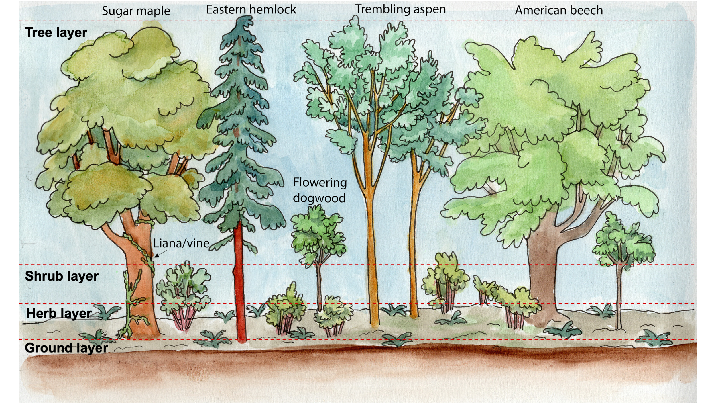
Forests are complex associations of tall, woody vegetation (trees, both alive, and as standing dead wood) and smaller stature species of woody shrubs, herbs (e.g., ferns and ephemeral flowering plants like lilies), as well as a ground layer that includes living plants (eg, mosses, lichen), and dead, decaying litter on the forest floor. The vertical and horizontal distribution of these different subsets is the forest structure (Figure 12.1).
Structure encompasses a variety of properties related to these different structural layers that influence ecosystem function. For example the depth and extent of the forest canopy that intercepts solar radiation influences the micro-climate (temperature, shadiness) of the forest understory. The number and position of nesting cavities in tree trunks influences wildlife habitat and the trophic functioning of the ecosystem. The number of tip-up mounds produced by fallen trees affects conditions for plant establishment…
Forest ecologists are often interested in how species in the tree layer are distributed into different size classes (small, medium, large), as measured by tree height and diameter. Tree diameter, the distance through the centre of the trunk, is generally measured at chest height. This information can hint at when the trees established, which species are dominant, especially in the canopy (in terms of size and abundance), which species are likely to replace the canopy species (the species of smaller stemmed individuals) and more. Therefore, the present structure provides clues about forest history and its future development.
Background Information About the Tour Location
Park History
The Park was initially a part of the UBC Endowment Lands which were set aside in 1923 by the BC government to be used as a source of revenue for the fledgling University of British Columbia. Logging for export to European markets was the main revenue generator. Eventually, all but a narrow band of forest along the western tip of Point Grey was harvested. Today the forest is mostly second growth that established after logging or more recent disturbances. In 1975, the provincial government designated part of the UBC Endowment Lands as an ecological reserve and Pacific Spirit Park was established in 1989 (UBC Geography, 2019).
Vegetation and Soils
Both human activity and soils influence the tree and understory plant species across the park. Differences in the kind of past disturbance as well as the severity and timing, have contributed to the patchwork of varied plant associations throughout the park. The soils vary considerably among locations, although they are influenced by the same general climate and have common parent materials. Podzols underlie much of the park and are characterized by a leached layer where minerals and decayed organic matter have been removed by rain seeping through the soil. Differences in soils between sites can be attributed to the growth and decay of organic material, which itself varies between sites based on local topography, the distribution of water and drainage of rainfall, and vegetation cover (UBC Geography, 2019). A video interpreting the soils in the Park in the second growth needleleaf forest is available at Second Growth Forest – Soil Description.
Dichotomous Key to Common Trees in Pacific Spirit Park
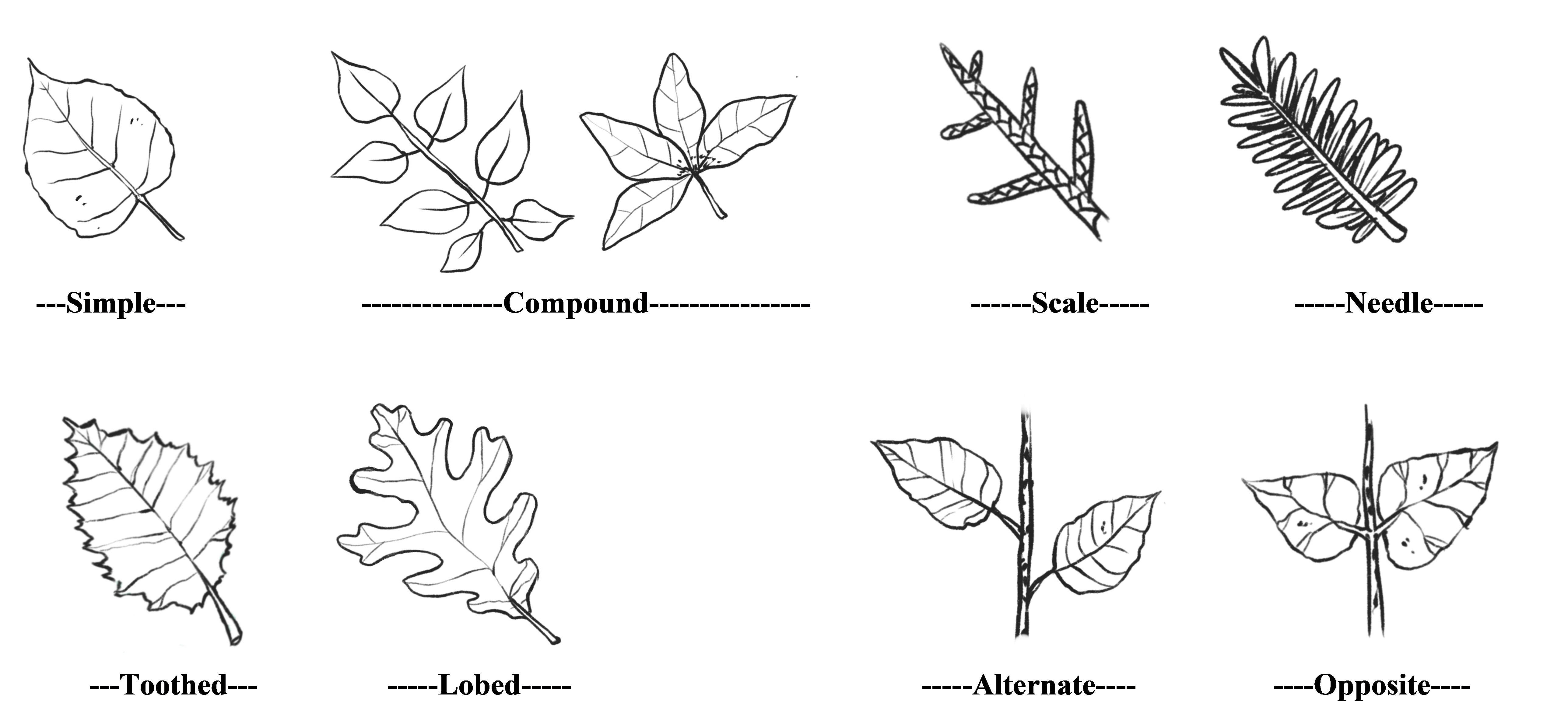
A key is a tool for identifying plants. Download and view the Key to Common Trees in Pacific Spirit Park from the Supporting Material. A simplified Pictorial Key to Common Trees in Pacific Spirit Park is also available for you in the Supporting Material, but you should be able to work with the language in the text-based key. This is called a dichotomous key because characteristics of the plant are described in couplets (e.g., 1a and 1b). For each species, only one of the two statements is accurate. For each accurate description, follow the instructions indicated in the right column; continue to the next pair of couplets or note the identification of the plant. Ultimately you will determine the genus and species of each plant using this key or by referring to other field guides. Remember to follow protocol when using scientific names of plants. An asterisk (*) next to a species name in the key indicates non-native species.
It is important to learn how to use a plant key and to become familiar with the vocabulary used to describe plants. The vocabulary is very specific to plant taxonomy and requires some attention. In particular, the following terms will be useful when using the key:
- Simple: a broadleaf, with only a single blade and is joined by its stalk to a twig or branchlet that is woody.
- Compound: a broadleaf, with several distinct leaflets attached to a midrib that is not woody. It is the stalk of the midrib that is attached to the woody twig.
- Leaflet: leaf-like subdivision of compound leaves, species usually have a characteristic number of leaflets per leaf.
- Alternate: leaves (simple or compound) are arranged singly at intervals along the twig.
- Opposite: leaves (simple or compound) that occur in opposing pairs along the twig.
- Lobed: a leaf with incompletely separated, rounded or bristle-tipped sections.
- Toothed: a leaf having large, dentate or serrate teeth at its edges.
- Palmate – leaf structures (e.g., veins or leaflets of compound leaves) radiating out from a common point
- Pinnate – leaf structures (e.g., veins or leaflets of compound leaves) distributed along a central line
- Branchlet: the end portion of a branch containing the previous year’s growth
Illustrations of a number of these features are provided on Figure 12.2.
Lab Exercises
In this lab, you will
- Identify BEC zones and related climate information.
- Examine the forest stand structure and species composition of Pacific Spirit Forest along the Spanish Trail through an immersive virtual tour.
- Complete a self-guided tour on which you will identify plants growing in your local neighbourhood.
This lab consists of 4 exercises. Exercises 1-3 are completed online and should take about 2-3 hours to complete Exercise 4 includes outdoor data collection and should take an hour or so.
EX1: Identify the BEC Zone for the Forest Tour
BC’s original coastal forest ecosystems have been classified using the Biogeoclimatic Ecosystem Classification System (BEC zone). In this exercise you will identify the two main types of coastal forests in BC, including the one where this tour is situated. This exercise should take 10-15 minutes to complete.
Step 1: Open Google Maps and enter these coordinates to locate the tour: 49°16’07.9″N, 123°14’09.5″W (49.268851, -123.235963).
Step 2: Go to the Climate BC map. You can find instructions for navigating this site in Lab 10 under the section, “Climate and Biogeoclimatic Ecosystem Classification (BEC)”, under Steps 1-4. Locate the tour area by zooming into the map near known features (e.g., coastlines, rivers) based on the location you have identified in Google Maps.
Step 3: In Climate BC map, select BEC Zone at the top under Overlays. The map will be coloured by BEC zone. Navigate to the area of Pacific Spirit Park, using the landmarks on Google Maps if you need to. Find zone abbreviation for the BEC zone. Note neighbouring zone abbreviations. What do the abbreviations stand for? You can find out at: About BEC and BGC units.
Step 4: Go to Biogeoclimatic Zones of British Columbia. Click on the zone name that you identified in Step 3. You will see just that particular zone highlighted on the map. Download the brochure for that zone to see its description at the URL at the top of each webpage, below the zone name. You will find information about the environment, vegetation and wildlife, and more.
Using websites in Step 3 and Step 4 of this exercise, briefly describe the following:
- The climate conditions, including temperature and rain/snowfall conditions of Pacific Spirit Park’s BEC zone. A climograph of the region is available for your perusal at Climate Vancouver (Canada).
- The main ecosystem characteristics, and 3-4 of the major tree species found in this zone (2-3 sentences). Note that this zone is variable within, and you may not see all of these species along the tour.
- The name of another adjacent/nearby coastal forest type common in the region (which you can locate using the Biogeoclimatic Zones of British Columbia website in this step), and one difference between it and the Pacific Spirit Park’s BEC zone (if any).
EX2: Take the Tour!
Now that you are aware of the regional context, you are ready to begin the tour. It starts at the head of the Spanish Trail where College Highroad meets Pacific Spirit Park as shown on the Pacific Spirit Forest Tour in Map 12.1 below. To zoom into the map, use the + icon. You may click the blue markers and a sidebar will appear with a brief overview of three major locations we will visit on the tour.
Map 12.1. Pacific Spirit Forest Tour Map.
Note: For a more immersive experience, at anytime you may try this Interactive 360 H5P version of the Pacific Spirit Forest Tour. Only the 360 photos and videos are embedded, however, so you will need to view the other learning materials (photos, text, linked resources) in the body of this lab.
We respectfully acknowledge that this tour takes place on the traditional, ancestral and unceded territory of the xʷməθkʷəy̓əm (Musqueam) People. We are grateful for the chance to study and enjoy this ecosystem, which they have sustained for millennia, and continue to do so.
Introduction
Step 1: Watch the tour introduction in Video 12.1. This is a 360 video, so you may click and drag within the video to explore the .
Video 12.1. Introduction to Pacific Spirit Park Tour. Transcript available: [Word] [ODT] [PDF]
As you learned in Video 12.1, the disturbance event that led to stand initiation here was a human-caused one. In 1952 the site was cleared of trees, stumps, and even topsoil to make way for a residential development. Clearly, the development plan did not go through, explaining why you see second-growth forest here, rather than apartments! Broadleaf, deciduous tree species regenerated spontaneously following the disturbance.
Step 2: Click and drag within 360 Photo 12.1 to explore the head (start) of the Spanish Trail in 360°.
360 Photo 12.1. The Spanish Trailhead.
Step 3: Using Video 12.1 and 360 Photo 12.1, be a field ecologist and apply your observational skills, paying particular attention to visible evidence of:
- Species composition: inferred from, e.g., bark characteristics (color, texture/pattern); plant type, based on life-form by forest layer (shrub vs. tree; see Figure 12.1), stem morphology and branch pattern, etc.
- Age structure: inferred from the range of stem sizes visible. Is this a stand with even-aged stems or one with stems in lots of different size/age categories? Note your responses.
Stop #1: Broadleaf Forest
Before we move into this first stop, a word of clarification about the terms broadleaf and hardwood. Broadleaf and hardwood are terms related to morphology and forestry. They both refer to woody, angiosperm (flowering plant), taxa. Broadleaf refers to the leaf shapes typical among woody angiosperms (as opposed to needleleaf, which you will meet at Stop #2). Hardwood refers to the harder (more dense) wood typical of these species.
Step 4: Watch Video 12.2 Broadleaf (Hardwood) Forest.
Video 12.2. Broadleaf (hardwood) forest. Transcript available: [Word] [ODT] [PDF]
Step 5: Click and drag within 360 Photo 12.2 to explore Stop 1 in 360°.
360 Photo 12.2. Stop 1: Broadleaf forest.
360 Photo 12.3 is the same scene in midsummer, June 17 2020, when deciduous trees had leafed out.
360 Photo 12.3. Stop 1: Broadleaf forest. June 2020.
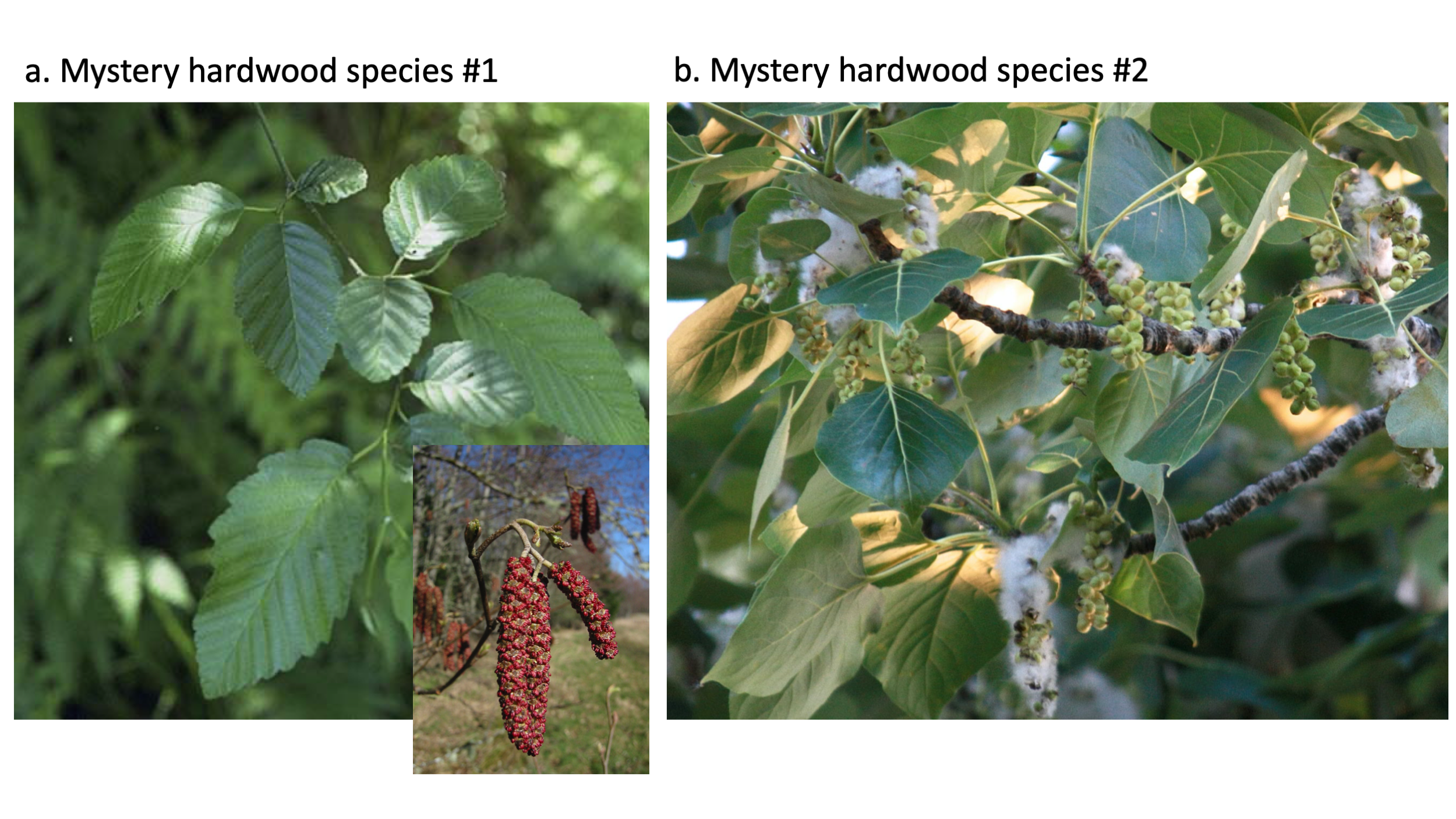
Ideas to consider before proceeding to the next step: Can you identify the two main species discussed in the video and shown in Figure 12.3? Use your Key to Common Trees in Pacific Spirit Park to find their Latin binomials and common names. Both species are early successional, and these individuals recruited shortly after the site had been disturbed when there was no tree canopy, little competition, and ample light. One of these species is more abundant (common) than the other in this forest. You should be able to determine which by looking around the photosphere once you can identify each from its bark (seeVideo 12.2 for clues) and other features, even without leaves on the trees!
Have a think about the sorts of characteristics these species have that allow them to arrive and thrive in recently disturbed sites. You may wish to refer to your text or lecture materials. These characteristics are adaptations, traits that evolved over time that help to match the species with the type of environment for which it is specialized. In this context, examples of the type of environment include open, recently disturbed sites and shady, undisturbed sites). A few considerations:
- Seed size vs. seed numbers: There is often a trade-off between the size of a species’s seeds and the number it can produce with limited resources – species tend to fall into categories, either producing many small seeds (many-small), or else few large seeds (few-large) (Leishman, 2001).
- Seed dispersal characteristics: Do the seeds have appendages such as plumes or wings to be scattered broadly by wind, or do they have tasty coverings to attract animal dispersers and be placed in specific locations? For further details, read Seed Dispersal – How Plants Spread. More importantly, how do these dispersal syndromes affect the chances of arriving and surviving in particular sites? Hint: Species in the many-small seed category have a decent chance of at least some arriving in recent openings. Species that produce a few large seeds have larger seed nutrient reserves to enable establishment in closed, shady sites where sunlight at the ground may be limited. At the same time, in these coastal forests, most tree species fall into the many-small seeds grouping. Nature often defies our simple attempts at categorization!
Are there other sorts of disturbances that might affect the forest? You might see some clues of more small-scale disturbance in 360 Photo 12.2 and 360 Photo 12.3. Clues include broken branches and signs of disease. Refer to your text or lecture materials for a discussion of disturbances, small and large-scale.
Have a think about how this site will change in future. The answer will be relevant in EX3. Go to the next step for more clues.
Step 6: View Video 12.3 in which Kevin Pierce chats about clues that indicate how this early successional broadleaf stand may change. Kevin is a UBC Geography PhD candidate and Teaching Assistant (2017-18) who led students on in-person field trips to this forest (shared with permission from KP; videographer, K Hurley, Mar 2019).
Video 12.3. Interpreting the Forest Structure and Signs of Change. Transcript available: [Word] [ODT] [PDF]
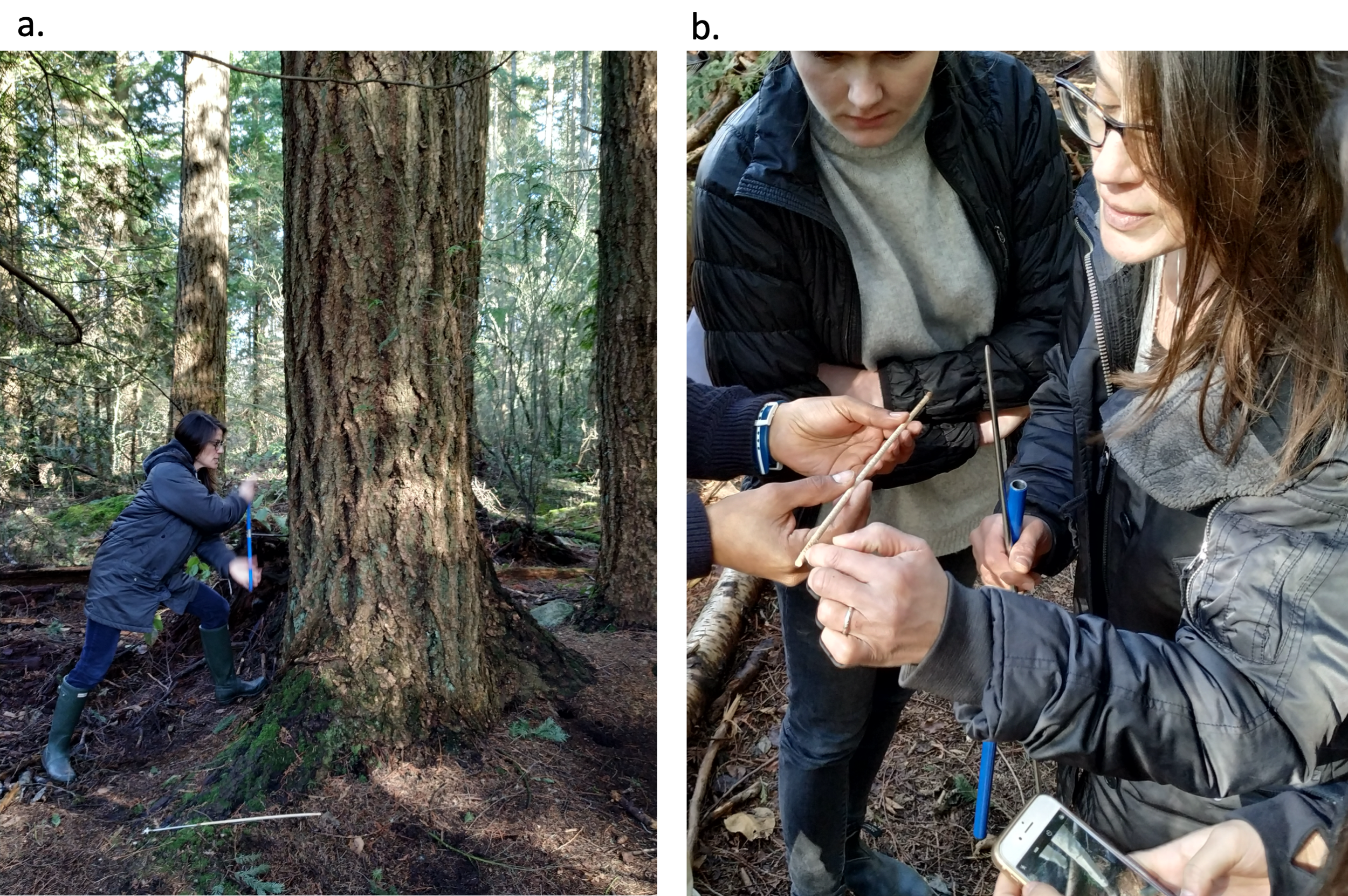
Step 7: Now watch Video 12.4 in which biogeographer Nina Hewitt demonstrates how to date disturbance. In the video, a ring series known as a tree-ring core is extracted from one of the largest, and oldest, stems at Stop 1. The ring counts and age of this tree tell how long ago it established, indicating the approximate timing of the disturbance event that led to stand initiation at the site. This is species x – the one you were asked to identify first.
Video 12.4. How to Date Disturbance. Transcript available: [Word] [ODT] [PDF]
With this information and your Key to Common Trees in Pacific Spirit Park in hand, you should be ready to answer the first few questions in EX3.
Next, proceed to the boardwalk site….
Boardwalk Site
Step 8: Watch Video 12.5.
Video 12.5. Spanish Trail Boardwalk. Transcript available: [Word] [ODT] [PDF]
Step 9: Click and drag within 360 Photo 12.4 to explore the Boardwalk site.
360 Photo 12.4. Spanish Trail Boardwalk.
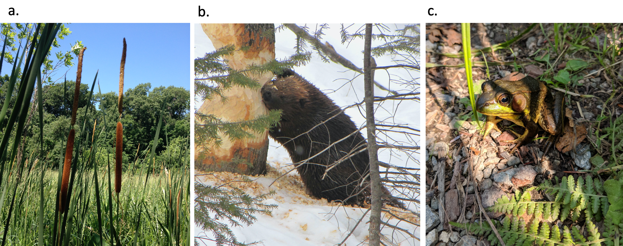
Based on the information you learned, can you identify the sort of disturbance that occurred here at the boardwalk? How/Why? Hint: What do you know about Canada’s national animal (seen on Figure 12.4b)? Can you work out what the effect of this disturbance was on the ecosystem and what sorts of species it facilitated (allowed to live here in its aftermath)?
Entering the Needleleaf Forest and a Look at Some Recently Introduced Species
Step 10: A few steps along from the Boardwalk Site, we arrive at the boundary of the needleleaf forest. Some of the herbaceous vegetation found here is worth examining. Watch Video 12.6 for details and to meet our first example of an invasive species.
Video 12.6. Entering the Needleleaf Forest. Transcript available: [Word] [ODT] [PDF]
In Video 12.6, a shrub species native to this forest, salal [VIDEO], was highlighted. Find out more about this and other native understory species, including Red huckleberry [VIDEO], Sword fern [VIDEO] and Dull Oregon grape [VIDEO] at Coastal Plants of BC, filmed here in Pacific Spirit Park!
Invasive species: Another species highlighted in Video 12.6 is non-native. As you may infer from Figure 12.5, this European invader has been very successful at colonizing the broadleaf forest, with several individuals visible in the photo. Can you think of some adaptations that have made it so successful in this ecosystem?
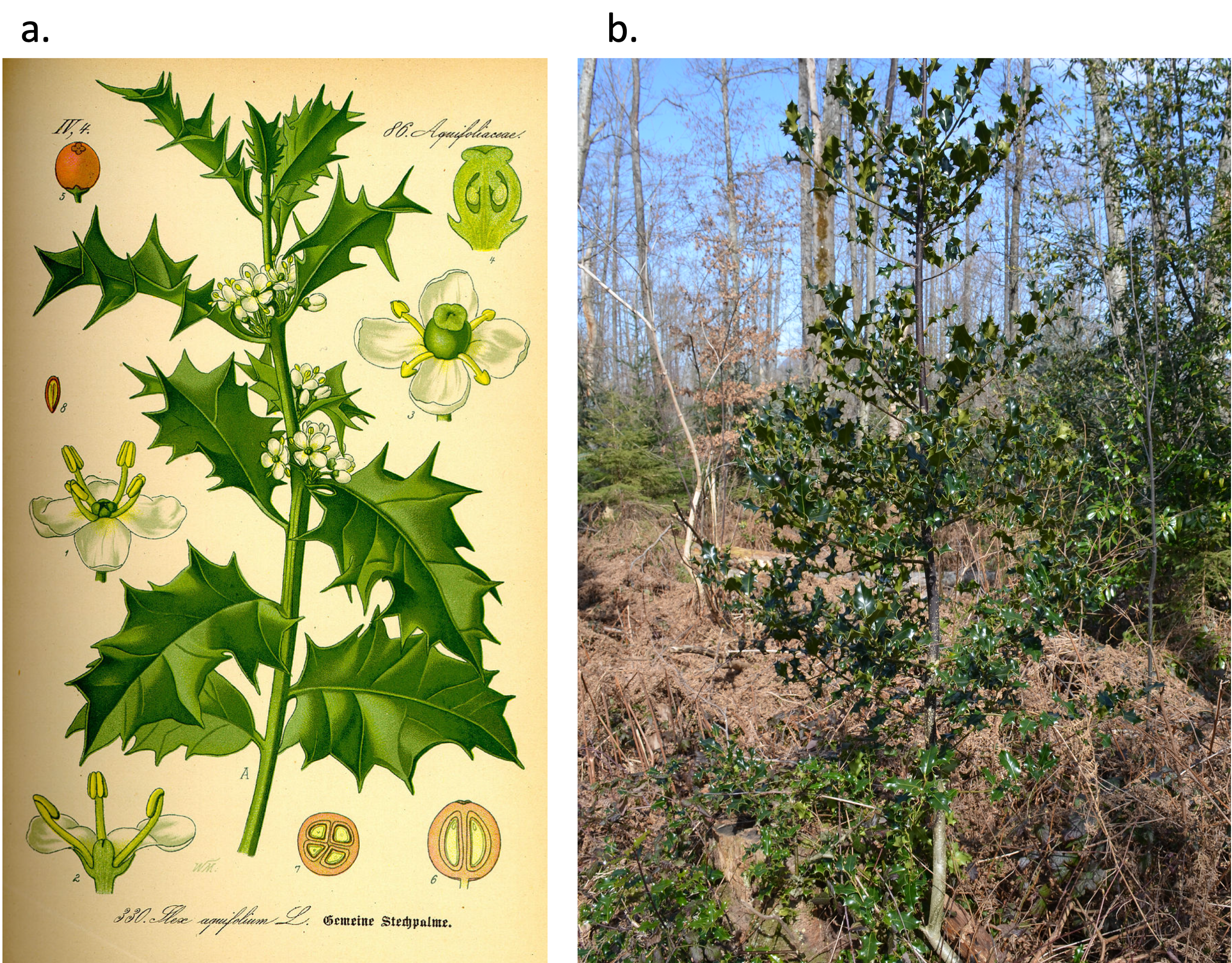
Another introduced invasive species present in the park is European laurel (Prunus amygdala). Note that both of these European invaders are evergreen woody species adapted to environments with mild rainy winters, so they have been introduced in a place with a climate that closely matches their origin. They also produce many berries that animals disperse. If you wish to explore the topic of invasive species, see e-flora BC’s Invasive plant species page.
Stop #2: Needleleaf Forest
Step 11: Watch Video 12.7. This video was filmed in March.
Video 12.7. Needleleaf forest. Transcript available: [Word] [ODT] [PDF]
Step 12: Click and drag within 360 Photo 12.5 to explore the needleleaf forest, Stop 2.
360 Photo 12.5. Needleleaf forest.
Step 13: For further information about the stand here at Stop #2, see the 360 Video 12.8 filmed later in the season (in June). As this is a 360 video, so you may click and drag within the video to explore the area in 360°.
Video 12.8. Needleleaf forest later in the season. Transcript available: [Word] [ODT] [PDF]
You have entered a remnant of a native coastal forest of the kind you identified using BC’s BEC System in EX1. Notice the larger (and older) canopy trees relative to those in the broadleaf forest, indicating the longer time since major disturbance. This stand established following logging and burning in the 1920s, regenerating naturally thereafter. Planting or seeding later became common practice in clearcut sites in BC.
Consider the kinds of site conditions present here: cool and shady or hot and sunny – which? How do they affect the sorts of species growing here (and visa versa)? Identify the three conifer (needleleaf) species discussed in the video based on their leaves and bark, using your Key to Common Trees in Pacific Spirit Park. You will come back to this in EX3.
Other native species in this forest include the small understory Acer (maple) species mentioned in Video 12.7. There is also a canopy species of maple with very large leaves (see your key!). The latter large-leaved maple is sort of a co-dominant species in this forest. It is shade-tolerant and reaches the canopy alongside the three conifers in late-successional stands. Find both in your Key to Common Trees in Pacific Spirit Park. For precise botanical information on the understory maple species, watch this vine maple video. Now, you may wish to try this tree species ID knowledge test.
In 360 Photo 12.5, notice the large pile of earth with young hemlock trees (saplings) growing on it along the east side of the trail (opposite from the dog). This is a tree-fall or tip-up mound, an important micro-habitat and safe site for many forest species, including Red huckleberry and Western hemlock. Safe sites refer to areas protected from hazards, such as burial from leaf-litter, that provide suitable conditions (fresh, exposed soil) for species’ seed to germinate and establish. These sorts of micro-habitats become more available in complex environments such as this, where forest trees have had time to live out their life cycles, decay, and create a decomposed stump or branch litter, for example.
More about Pacific Spirit Forest, Past and Present
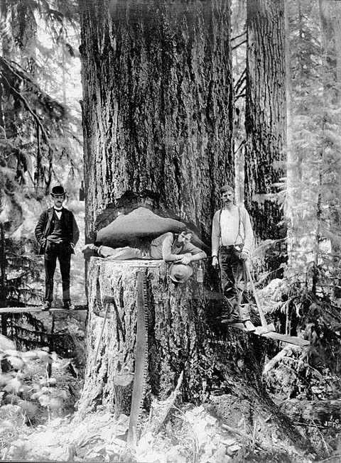
Like the area at Stop 1, this area experienced large-scale human disturbance, but less recently. In this case the large-scale disturbance was extensive logging/tree-cutting. See a photo of what the site must have looked like soon after the disturbance at Clearing the Point Grey Campus (1914, UBC Archives). One may assume that the forest today is approaching a size (age) structure and species composition of a late successional stand, perhaps one that more closely resembles the historical forest, common throughout the region prior to colonization. Successional changes have thus proceeded for longer than at Stop 1, and this greater time since disturbance helps to explain the difference in species composition and structure between the two sites. That said, it probably lacks the complexity and very large, old (greater than 500 years age) stems that might have occurred otherwise on sites that escaped periodic fires. Figure 12.6 demonstrates the use of an increment borer, which is one tool used to determine the age of trees, and hence date the time of disturbances.
There are other sorts of disturbance here including some more regular, small-scale disturbances. When we take students through this site, we pass some burned out stumps.
Think about the forest before the logging event. It would have supported stems much more massive than those present (Figure 12.7).
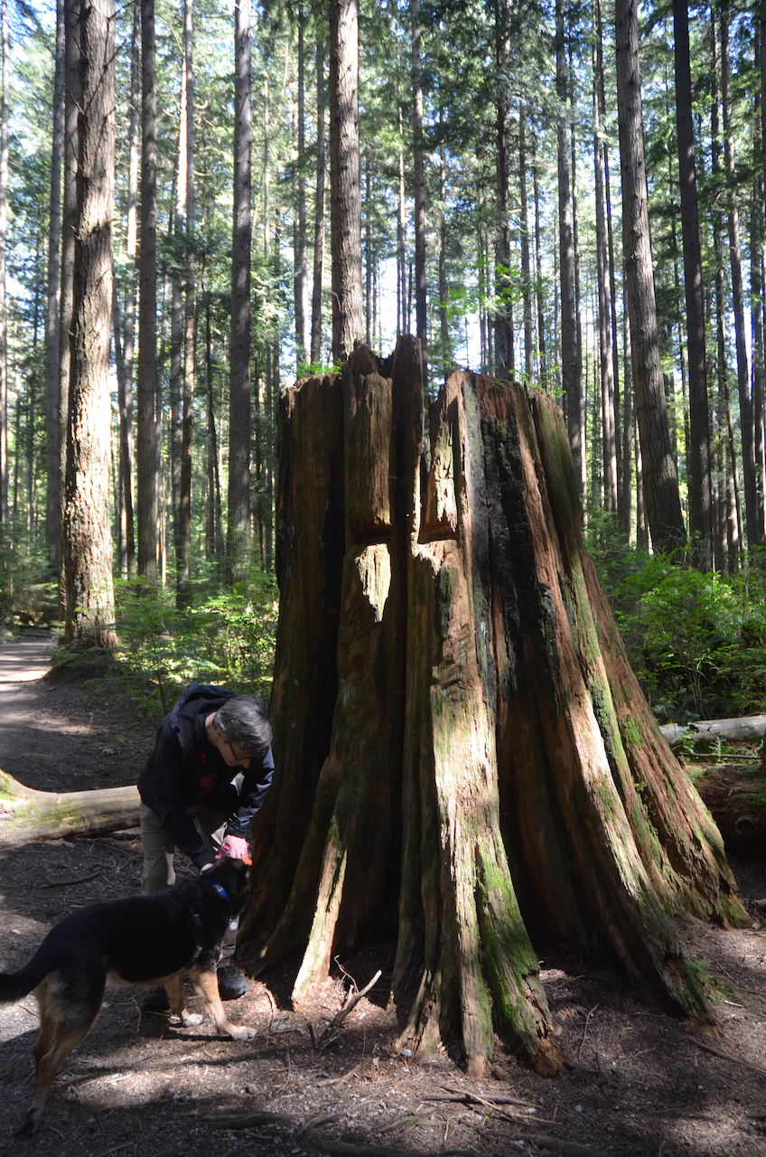
Stumps associated with these wide-scale logging events are found throughout Pacific Spirit Forest (Figure 12.8). How do you think the university’s extractive forestry practices affected the ecosystem? Would there have been long-term impacts on structure and function? Of course, disturbance and change is a normal feature of ecosystems, but perhaps the scale of destruction from logging operations was atypical? In this sense, this little piece of needleleaf forest represents an altered remnant, and may be illustrative of the Anthropocene.
Consider how post-settlement forest practices compare to those of the the xʷməθkʷəy̓əm (Musqueum), the traditional and ancestral people of Point Grey. One Indigenous practice of forest harvesting, cedar bark stripping, was touched on in the video. This practice is non-destructive: trees survive, gradually sealing off wood where bark is stripped via cambial tissue growth (growth from cambial cells located just beneath the bark that produce the tree’s annual rings). Affected trees retain residual scars that identify them years later, and are referred to as culturally modified trees (CMT).
EX3: Interpret What You Have Seen and Learned
Stop #1: Broadleaf Forest
- For the dominant tree species, identify the species and give both its common and scientific name. Note: it is scientific protocol to either underline or italicize scientific names. Genus names are capitalized and the species names are lower case.
- Common name of the dominant tree.
- Scientific name of the dominant tree.
- List two diagnostic features from the Key to Common Trees in Pacific Spirit Park in the Supporting Material that you found most helpful to identify the dominant tree species.
- What was the main disturbance that initiated this broadleaf forest?
- Based on your observations, list two other disturbances (besides the hiking trail) that appear likely to have occurred in this forest. Provide evidence for each one.
- Name the pioneer tree species in this forest and describe at least two specific attributes (adaptations) that help it to be an effective pioneer species.
- Based on your observations, how might the broadleaf forest change in the future, assuming it continues to undergo succession without any further major disturbances? State two possible ways the forest might change or develop.
- The trees in this forest are deciduous and lose their leaves each autumn. Do leaves contribute to organic soil horizons, mineral soil horizons, or both? Briefly explain your answer.
Stop #2: Needleleaf Forest
- Use the Key to Common Trees in Pacific Spirit Park in the Supporting Material to identify three common tree species in the needleleaf forest. Give both their common and scientific names. Explain at least one diagnostic feature you found most useful in identifying each. These could be features mentioned in Video 12.7 or observed on the specimens and seen in the key.
- Name the two maple species discussed at Stop 2 and mentioned in the Key to Common Trees in Pacific Spirit Park, and in Video 12.7. Identify which is a small understory species and which is emergent, in the canopy.
- Name the dominant species (one or potentially more) in the needleleaf forest. Briefly explain what information you based this assertion on. That is, what did you observe in Video 12.7 and/or 360 Photo 12.5 to suggest that this was the case?
- Based on your observations, list two disturbances that have occurred in this forest and explain why you listed these. What information did you notice/draw on?
Important: Were we to continue down the trail a few metres, we would arrive at the site of a charred tree stump. Other sorts of small- and large- scale forest ecosystem disturbance types are discussed in your course readings and in NRCan – How does disturbance shape Canada’s forests? (in particular, the literature cited list).
- In the needleleaf forest stand we touched on a few characteristics, or ecosystem properties, that occur in these less-recently disturbed sites, and are important from a biodiversity standpoint. Describe one characteristic/property and explain why it matters from an ecosystem or biodiversity standpoint.
- If disturbance occurs and creates large canopy openings, which tree species do you predict will colonize the openings? Justify your choice. Hint: There are two possibilities. One of them is growing in the canopy at this site, and acts as a sort of pioneer species in large openings in this otherwise mature forest.
Questions 1-8, 10, and 11 are adapted from UBC Geography (2019).
EX4: Self-Guided Plant Identification in Your Location
Safety note: do NOT complete this exercise until receiving a safety briefing and filing the proper paperwork (if applicable). Your first responsibility when arriving at a site is to ascertain whether or not the terrain is safe to traverse. If not, find a new location.
Get to know some of the species of trees growing near you by identifying two species in your immediate landscape. You may find the trees in a garden, along your street, in a park or nature preserve or in an outdoor recreational area you visit.
Tips for finding species information:
- The Key to Common Trees in Pacific Spirit Park (or Pictorial Key to Common Trees in Pacific Spirit Park, both in the Supporting Material) will assist you in distinguishing needleleaf and broadleaf species, but if you are not in BC, the taxa will differ at the species and possibly genus level.
- If you are unable to determine species’ identity with reference to online guides, take a photo with your phone and use one of several apps, including iNaturalist (download from: Google Playstore; App store) to identify it.
- To find whether native or non-native to your region, there are many online sites such as e-flora (here for E-Flora BC; or search for other parts of the world using scientific or common names). Wikipedia is often reliable (though no guarantees with crowd-sourced information!). If you have trouble finding information, ask your instructor for assistance.
Step 1: Find species.
Criteria to look for:
- Tree species (not shrubs/herbs/ferns).
- At least one should be a coniferous/needleleaf species. See your Key to Common Trees in Pacific Spirit Park to ensure you find one.
- At least one should be a broadleaf/hardwood tree. See dichotomous key for indicators. Note that a common street tree in North America, and native to Asia, Ginkgo biloba, is not a broadleaf/ hardwood (angiosperm)—it is taxonomically related to needleleaf/ conifer (gymnosperm) species, but its appearance is deceiving!
Step 2: Identify and document your species.
List the names, both scientific and common, for each of your species and take a photo of the leaves and bark/ any cones or flowers/seeds to include in your submission.
Step 3: Indicate the species’ origin.
State whether each species is native to your location or non-native and if the latter, where it originates.
Step 4: Estimate its commonness/abundance in the local landscape.
State whether it is one you have noticed frequently in which case it may be labelled abundant/common in your location, whether it is not common, or you don’t know (since this information is often complicated by human land management and cultivation practices and may not be easily determined).
Step 5: Note other relevant details.
Some details that might apply include:
- Is the individual you saw cultivated (planted) or wild (recruited naturally)?
- If the species are native to your area, can you specify its niche or role in the local ecosystem?
- If non-native, how do you think it got there—intentionally (brought in to be planted/cultivated) or unintentionally? Provide brief notes to explain your reasoning.
Step 6: Species Summary
Combine the information you gathered in Steps 1-5 into one short paragraph per species. Insert photos photos of each species, making sure that you give each photo a descriptive caption.
Reflection Questions
- How did the species you identified in the needleleaf forest compare to those you noted from the ecosystem classification for this BEC zone in EX1? How did the species composition differ? Indicate any species in the BEC zone description that were present and ones were absent or in addition to what you had expected. What might account for these differences? Consider ecosystem controls, and factors that determine plant populations. Note that randomness is a factor influencing plant populations and patterns of species distribution!
- One of the woody species we glimpsed in both forest types is an introduced species (see Video 12.6, filmed as we enter the needleleaf forest). It is known for its evergreen leaves with pointed edges and for its red fruits. Use the key to identify this species. Name the species and state which world region it originated from. You also learned of at least one other introduced species on the tour. What impact do these sorts of invasive species have on native species in the forest? What actions do you think could be taken to manage invasive species and the threat they pose to biodiversity? (one paragraph with the species information and your thoughts)
Supporting Material
Keys to Common Trees in Pacific Spirit Park
Text version – recommended
- Key to Common Trees in Pacific Spirit Park [WORD]
- Key to Common Trees in Pacific Spirit Park [ODT]
- Key to Common Trees in Pacific Spirit Park [PDF]
Pictorial version
References
Hewitt, N. (2018). Chapter 10: Plant geography. In A. F. Arbogast, L. Ford, & D. Dagesse, Discovering physical geography, First Canadian edition. John Wiley & Sons.
Johnson, E.A., & K. Miyanishi. (2008). Testing the assumptions of chronosequences in succession. Ecology Letters, 11, 419-431.
Klinkenberg, B. (2020). Invasive Plant Species. In: B. Klinkenberg, Brian (Ed.), E-Flora BC: Electronic atlas of the flora of British Columbia. Lab for Advanced Spatial Analysis, Department of Geography, University of British Columbia. https://ibis.geog.ubc.ca/biodiversity/eflora/
Leishman, M. (2001). Does the seed size/number trade-off model determine plant community structure? An assessment of the model mechanisms and their generality. Oikos, 93(2) 294-302. https://www.jstor.org/stable/3547307
Straley, G.B., & R.P. Harrison. (1987). An illustrated flora of the university endowment lands. Botanical Garden Technical Bulletin, 12. University of British Columbia.
UBC Geography. (2019). Lab 4 handout: Soils, tree species composition and disturbance history in pacific spirit park. In GEOB 102, Our Changing Environment: Climate and Ecosystems Dept. of Geog., University of British Columbia.
Media Attributions
- 1 Introduction to Pacific Spirit Forest Tour along Spanish Trail by Hewitt Lab is licensed under a CC BY licence.
- 2. Video in Hardwood forest, Pacific Spirit_Stop 1 by Hewitt Lab is licensed under a CC BY licence.
- UBC GEOB 102 TA Interprets the Forest Structure and Signs of Change by Hewitt Lab is licensed under a Standard YouTube License.
- Dendrochronology: A tool to date past disturbance events by Hewitt Lab is licensed under a CC BY licence.
- 3. Video on the Boardwalk of Spanish Trail by Hewitt Lab is licensed under a CC BY licence.
- 4. Video Entering the Neede-leaf (Conifer) Forest by Hewitt Lab is licensed under a CC BY licence.
- Video in the Needle-leaf Forest, Stop 2 by Hewitt Lab is licensed under a CC BY licence.
- Needleleaf Forest, Pacific Spirit, June 2020 by Hewitt Lab is licensed under a CC BY licence.
Image Descriptions
Figure 12.1. Diagram of the structure of a forest and its layers
A schematic diagram of the structure of an eastern deciduous forest and its layers.
- Ground layer: at the bottom is the ground layer consisting of soil, rock, and material found within and associated with the soil.
- Herb layer: moving upwards, the next layer is the herb layer, which consists of vegetation that lies low to the ground.
- Shrub layer: the third layer is the shrub layer which consists plants with structures that allow them to grow taller than the plants that grow immediately on the surface.
- Tree layer: the fourth and final layer is the tree layer, which is the top of this schematic. Trees are vegetation with strong woody structures that allow them to grow taller than the low-lying vegetation. The tress that are shown in the diagram from left to right are: a sugar maple (with a vine growing on it), an eastern hemlock, a flowering dogwood, a trembling aspen, and an American beech.

![US Bureau of Land Management [JPG],](https://commons.wikimedia.org/wiki/File:Red_alder_leaves.jpg)
![W. Siegmund (2006) [JPG]](https://commons.wikimedia.org/wiki/File:Alnus_rubra_9819.JPG)
![Amiyashrivatstava (2012) [JPG]](https://commons.wikimedia.org/wiki/File:Seeds_and_Fluff_of_Cottonwood.jpg)
![Fritzflohrreynolds (2012) [JPG]](https://commons.wikimedia.org/wiki/File:Typha_angustifolia_-_Narrowleaf_Cattail.jpg)
![D. Robertson (2010) [JPG]](https://commons.wikimedia.org/wiki/File:American_Beaver,_tree_cutting.jpg)
![O. Wilhelm Thomé (1885) [JPG]](https://commons.wikimedia.org/wiki/File:Illustration_Ilex_aquifolium0.jpg)
![J.F. Ford [JPG]](https://commons.wikimedia.org/wiki/File:Logging_oregon.jpg)