Marine protected areas
The primary reason to develop Ecospace was to open up for evaluating the effects of MPAs on protected species and their ecosystems, along with the consequences of reallocation of fishing effort[1] [2] [3]. Several local and regional applications followed, covering a diversity of ecosystems including temperate and tropical ecosystems[4] [5] [6]. However, Ecospace MPA applications have only recently started applying the habitat foraging capacity model and the capabilities of the Spatial-Temporal Data Framework .
For example, Dahood et al.[7] developed an Ecospace model to analyze the food-web dynamics of an Antarctic marine protected area by simulating scenarios of sea-ice loss and fishing. Results suggested that no-take zones may be particularly important to enhance the resilience of species that have recently experienced population decline and to ensure positive outcomes from establishing a marine protected area in the region.
In Coll et al.[8] a series of local, sub-regional and regional Ecospace models were developed to assess how Mediterranean ecosystems associated with networks of MPAs (i.e., MPAs sensu lato) can sustain present conditions and future change of fisheries exploitation rates and patterns in a sustainable way. Potential configurations of MPA network(s) were investigated considering current protected areas (including Natura 2000 sites), already formally proposed areas (such as the Ecologically or Biologically Significant Areas or EBSAs), and other proposed areas not being formally recognized, such as the Areas Under Consensus or the Priority Areas for Conservation of Species at Risk (PACS) following Micheli et al.[9] and Coll et al.[10]. Different proposals were also tested to partially or totally close hake spawning and nursery areas to bottom trawling, and to extend the bottom trawling prohibition of coastal areas to 100 and 150 meters. In addition, the prohibition of bottom trawling below 1000 meters in the Mediterranean Sea was investigated (WWF/IUCN[11]), and other sustainable managed areas such as the Fisheries Restricted Areas (FRAs) as declared by the General Fisheries Commission for the Mediterranean Sea, GFCM were included.
To overcome a main limitation of MPAs in the region, which is their small size compared to the study area, Coll et al.[12] developed a geographically nested ecosystem modeling approach (Fig. 15), in combination with the Biomass Emitter plug-in (Steenbeek, 2018). This plug-in carries over biomass fluctuations obtained from fine-scaled local dynamics to corresponding spatial cells in coarser, more regional models as boosts in biomass to fished species, both landed and discarded (Steenbeek,[13]).
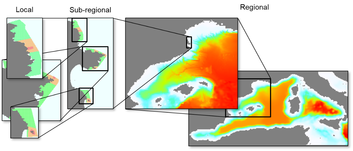
Figure 1. Geographically nested ecosystem modeling approach developed to assess the impacts of MPAs in Western Mediterranean Sea. Local areas include the MPAs of Cerbère-Banyuls, Cap de Creus, and Medes Islands MPAs (red area: no-take, orange area: partially-protected, green area: unprotected surrounding MPA). The sub-regional areas include the three MPAs and their surroundings to model the network of MPAs (reproduced from Coll et al.[14])
The Biomass Emitter can be parameterized with either relative or absolute biomass trends obtained for Marine Protected Areas from finer scaled models, from field data collected for different MPAs, or by applying empirical equations following previous studies. It can apply any number of biomass trends, as obtained from fine-scaled MPA models, to boost the biomasses of the same groups in corresponding spatial areas in coarser scale models. Through the Biomass Emitter, the biomass effect of an MPA as computed in fine-scale models is effectively carried over to coarser-scaled models that otherwise would have been unable to mathematically represent the impact of these MPAs (Steenbeek[15]).
Attribution
This chapter is based on de Mutsert K, Marta Coll, Jeroen Steenbeek, Cameron Ainsworth, Joe Buszowski, David Chagaris, Villy Christensen, Sheila J.J. Heymans, Kristy A. Lewis, Simone Libralato, Greig Oldford, Chiara Piroddi, Giovanni Romagnoni, Natalia Serpetti, Michael Spence, Carl Walters. 2023. Advances in spatial-temporal coastal and marine ecosystem modeling using Ecopath with Ecosim and Ecospace. Treatise on Estuarine and Coastal Science, 2nd Edition. Elsevier. https://doi.org/10.1016/B978-0-323-90798-9.00035-4, adapted with permission, License Number 5651431253138.
Rather than citing this chapter, please cite the source.
- Walters, C., Pauly, D., Christensen, V., 1999. Ecospace: Prediction of Mesoscale Spatial Patterns in Trophic Relationships of Exploited Ecosystems, with Emphasis on the Impacts of Marine Protected Areas. Ecosystems 2, 539–554. https://doi.org/10.1007/s100219900101 ↵
- Walters, C., 2000. Impacts of dispersal, ecological interactions, and fishing effort dynamics on efficacy of marine protected areas: how large should protected areas be? Bulletin of Marine Science 66, 745–757. ↵
- Walters, C., Christensen, V., Walters, W., Rose, K., 2010. Representation of multistanza life histories in Ecospace models for spatial organization of ecosystem trophic interaction patterns. Bulletin of Marine Science 86, 439–459. ↵
- Salomon, A.K., Waller, N.P., McIlhagga, C., Yung, R.L., Walters, C., 2002. Modeling the trophic effects of marine protected area zoning policies: A case study. Aquatic Ecology 36, 85–95. https://doi.org/10.1023/A:1013346622536 ↵
- Fouzai, N., Coll, M., Palomera, I., Santojanni, A., Arneri, E., Christensen, V., 2012. Fishing management scenarios to rebuild exploited resources and ecosystems of the Northern-Central Adriatic (Mediterranean Sea). Journal of Marine Systems 102–104, 39–51. https://doi.org/10.1016/j.jmarsys.2012.05.003 ↵
- Abdou, K., Halouani, G., Hattab, T., Romdhane, M.S., Lasram, F.B.R., Loc’h, F.L., 2016. Exploring the potential effects of marine protected areas on the ecosystem structure of the Gulf of Gabes using the Ecospace model. Aquat. Living Resour. 29, 202. https://doi.org/10.1051/alr/2016014 ↵
- Dahood, A., de Mutsert, K., Watters, G.M., 2020. Evaluating Antarctic marine protected area scenarios using a dynamic food web model. Biological Conservation 251, 108766. https://doi.org/10.1016/j.biocon.2020.108766 ↵
- Coll, M., Steenbeek, J., Pennino, M.G., Buszowski, J., Kaschner, K., Lotze, H.K., Rousseau, Y., Tittensor, D.P., Walters, C., Watson, R.A., Christensen, V., 2020. Advancing Global Ecological Modeling Capabilities to Simulate Future Trajectories of Change in Marine Ecosystems. Frontiers in Marine Science 7. https://doi.org/10.3389/fmars.2020.567877 ↵
- Micheli, F., Levin, N., Giakoumi, S., Katsanevakis, S., Abdulla, A., Coll, M., Fraschetti, S., Kark, S., Koutsoubas, D., Mackelworth, P., Maiorano, L., Possingham, H.P., 2013. Setting Priorities for Regional Conservation Planning in the Mediterranean Sea. PLOS ONE 8, e59038. https://doi.org/10.1371/journal.pone.0059038 ↵
- Coll, M., Akoglu, E., Arreguín-Sánchez, F., Fulton, E.A., Gascuel, D., Heymans, J.J., Libralato, S., Mackinson, S., Palomera, I., Piroddi, C., Shannon, L.J., Steenbeek, J., Villasante, S., Christensen, V., 2015. Modelling dynamic ecosystems: venturing beyond boundaries with the Ecopath approach. Rev Fish Biol Fisheries 25, 413–424. https://doi.org/10.1007/s11160-015-9386-x ↵
- WWF/IUCN, 2004. The Mediterranean deep-sea ecosystems An overview of their diversity, structure, functioning and anthropogenic impacts, with a proposal for their conservation. https://portals.iucn.org/library/sites/library/files/documents/2004-052.pdf. ↵
- Coll et al. 2020, op. cit. ↵
- Steenbeek, J., 2018. Biomass emitter plug-in - Quick Reference Guide ↵
- Coll et al. 2020, op. cit. ↵
- Steenbeek, J., 2018. Biomass emitter plug-in - Quick Reference Guide ↵
